
The largest online Iowa weather network. Bringing you the best weather coverage devoted only to online viewers. #iawx
Joined April 2010
- Tweets 11,285
- Following 2,677
- Followers 24,718
- Likes 5,835
6,878 Photos and videos


IowaWeather.com retweeted

Still have skmewhat of one south of St Mary’s IA

1
7
841
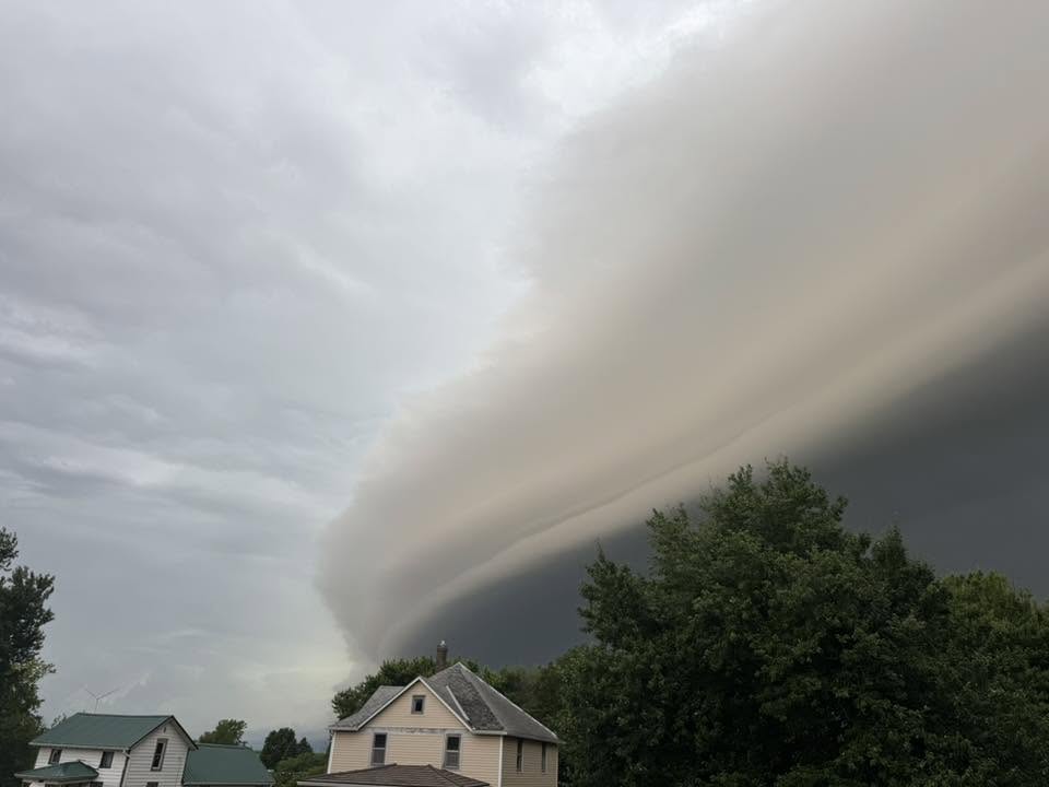
Here is another great view of the shelf cloud rolling into Walnut, Iowa. Thanks to Kelly Lumpkin for sharing this phot with us. #iawx #iowaweather
1
4
49
2,323
A severe thunderstorm capable of producing damaging wind gusts and large hail is currently moving east at around 50 mph across western Iowa.
As this storm continues its trek eastward, residents in its path should be prepared for rapidly changing weather conditions.
This impressive shelf cloud was captured near Oakland, Iowa by Elias Perez as the storm approached.
#iawx #iowaweather #weatherupdate #weather
1
6
42
3,710
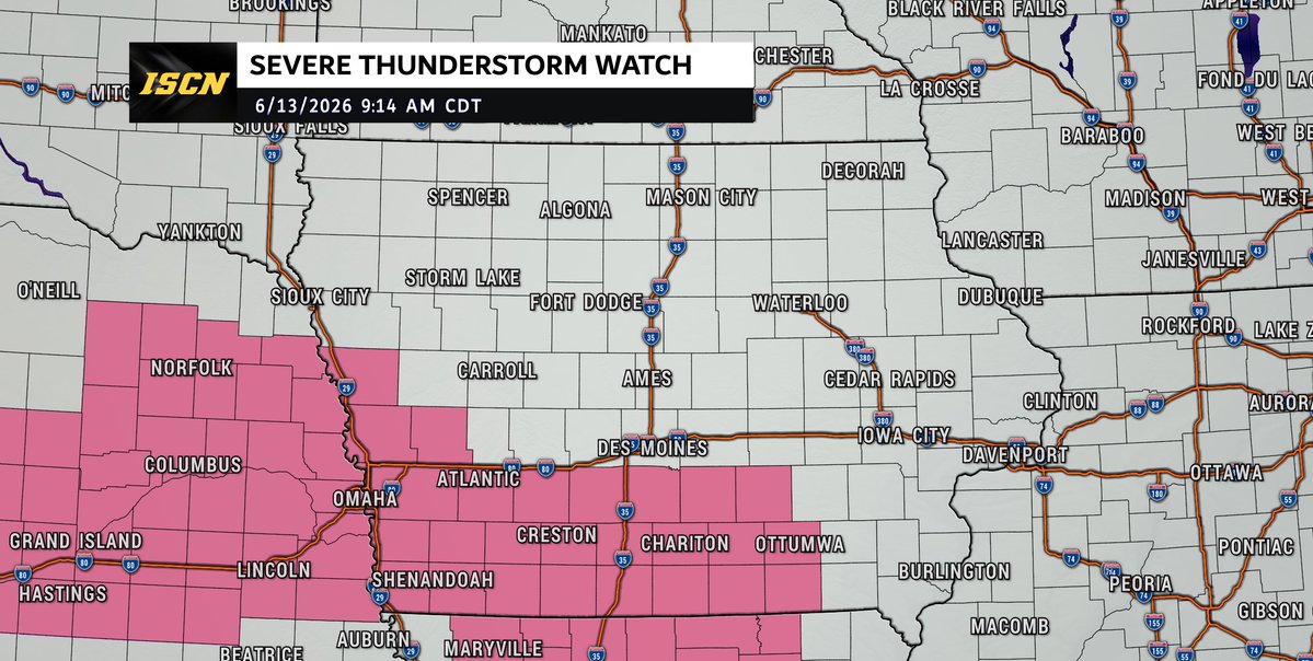
A Severe Thunderstorm Watch is in effect until 3 PM for portions of south-central Iowa.
A line of strong to severe thunderstorms moving through the region this morning is expected to continue east-southeast through the afternoon, bringing the potential for damaging wind gusts up to 70 mph and hail up to 1.5 inches in diameter.
The primary threat will be damaging straight-line winds, though isolated large hail is also possible. Stay weather aware, have multiple ways to receive warnings, and keep the ISCN Weather app handy for the latest updates. #IAwx
3
15
1,419

Jun 12
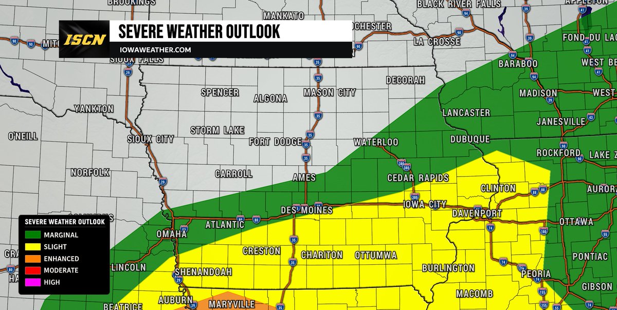
The Storm Prediction Center has placed much of southern Iowa under a Slight Risk (Level 2 of 5) for severe weather on Saturday afternoon and evening. While not everyone will see severe storms, some thunderstorms could become strong enough to produce damaging weather.
A cold front will move across Iowa throughout the day Saturday and will provide the focus for thunderstorm development. Forecast confidence is increasing that storms will develop during the mid-afternoon (after 2-3PM) and continue into the early evening (before 10PM), especially across southern portions of the state. However, there is still some uncertainty regarding exactly where the strongest storms will form and how widespread they become. The main threats with any severe storms will be large hail and damaging wind gusts.
We will continue to monitor the latest forecast trends and provide updates as confidence increases. Be sure to have the ISCN Weather app installed and check back throughout the day Saturday for the latest forecast updates and any watches or warnings that may be issued.
#iawx #iowaweather #severeweather
1
1
20
1,748
Jun 11
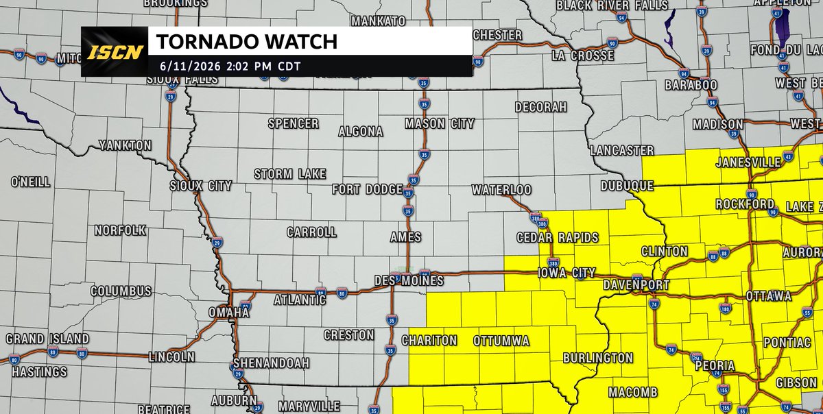
A tornado watch has been issued for parts of Illinois, Indiana, Iowa, Missouri and Wisconsin until 9 PM CDT. Issued at 2PM Thursday 6/11.
1
15
1,576
Jun 11
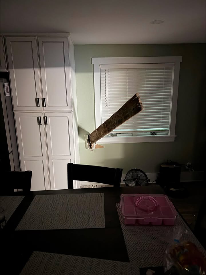
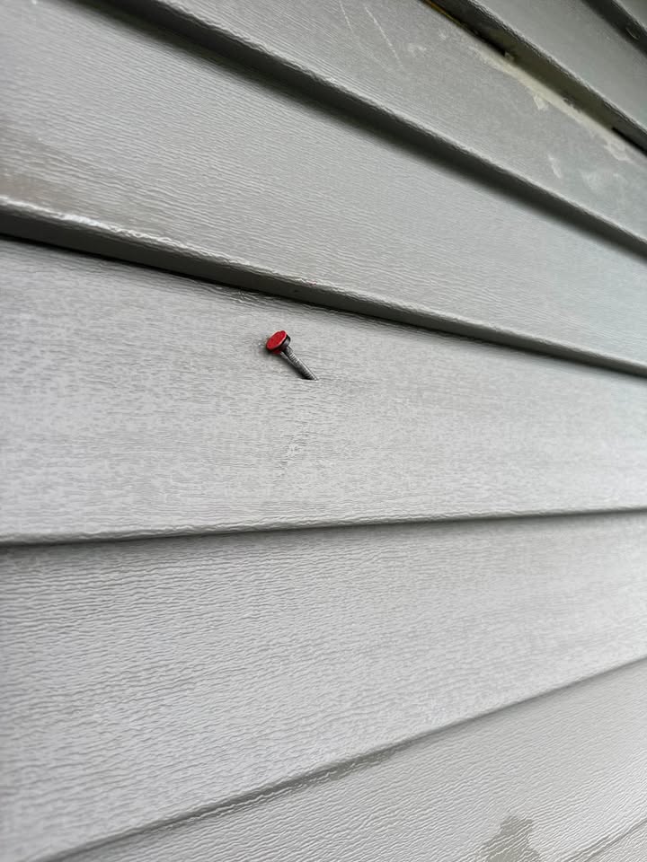
Check This Out!
John Hanson shared these incredible photos of the storm damage on his property between Villisca and Essex following this morning's severe weather.
One of the most remarkable examples of the power of the storm is a wooden board from his barn—located roughly 100 yards away—that was driven completely through the exterior wall of his home. He also found a nail from that same barn embedded in the siding of his house.
A 90 mph wind gust was reported in Essex, and a tornado warning was in effect for the area around 6:00 AM. While it is not yet known exactly what caused the damage at his property, these photos show the incredible forces that were at work during the storm.
@NWSOmaha
13
84
10,271

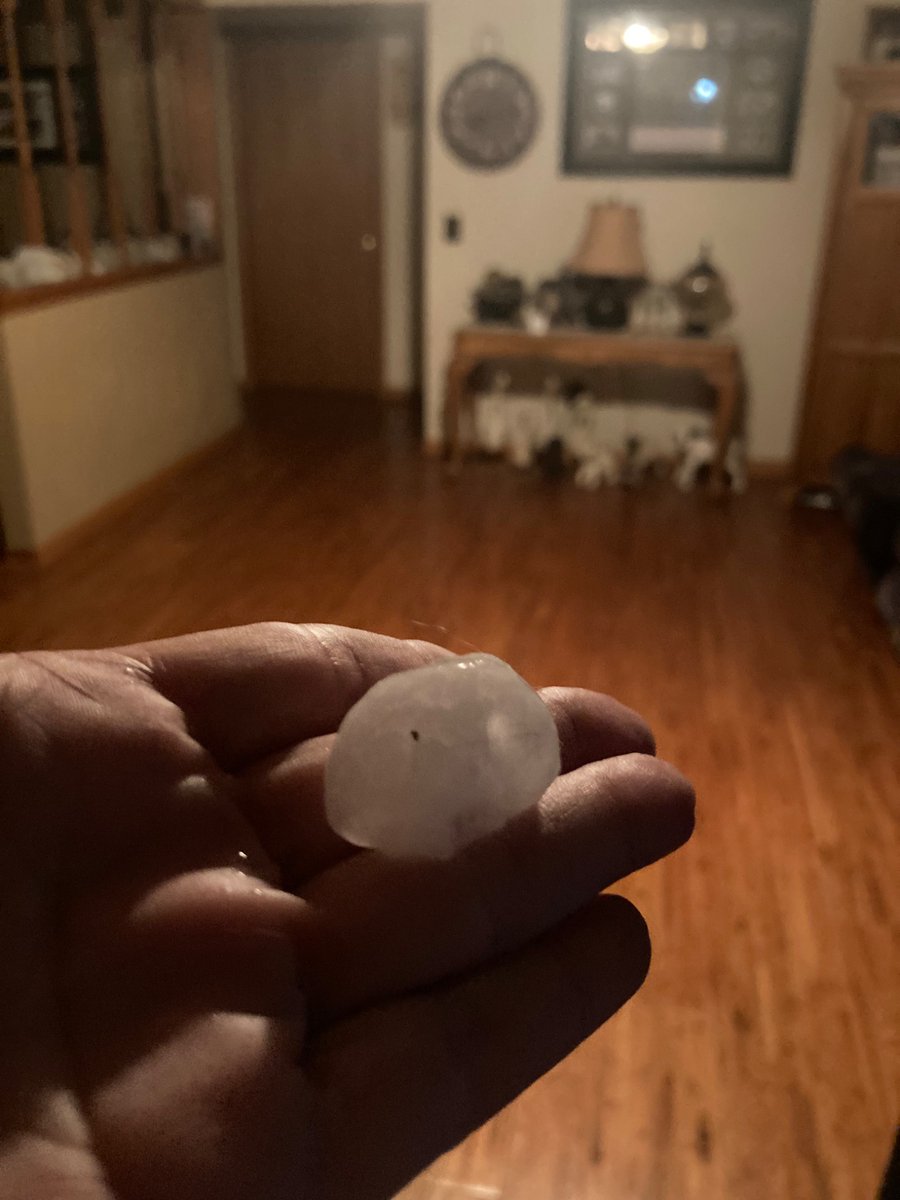
Quarter to golf ball size hail, in Oskaloosa this morning.
Video credit: Diana Crook, hail photo credit, Tina Crook.
#weather
#iawx
@NWSDesMoines
@WHOWeather
@JeriannWX
@dsmwx
@proughwx
@IAStormChasing
6
2
13
2,328
IowaWeather.com retweeted

Jun 11
Very strong bow echo racing eastward just to my north. Looking north of Centerville, Iowa. #IAwx @IAStormChasing @NWSDesMoines
1
7
56
2,398
Jun 11
Goodness this is breathtaking!

4
6
83
6,535
IowaWeather.com retweeted

Jun 11

2
31
1,672
Jun 10
A tornado watch has been issued for portions of southern Iowa until 9PM Wednesday evening.
1
11
1,728
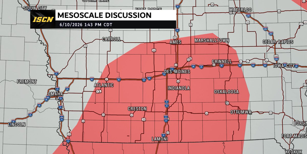
Jun 10
The Storm Prediction Center indicates a Tornado Watch is likely to be issued later this afternoon across portions of Iowa, with a 95% probability of watch issuance. Confidence continues to increase that severe thunderstorms will develop across western and central Iowa between 3 PM and 4 PM before spreading across southern and eastern Iowa through the evening hours.
The atmosphere is rapidly becoming favorable for severe weather, with increasing instability, abundant moisture, and strong wind shear in place. These ingredients will support the development of supercell thunderstorms capable of producing all modes of severe weather. If storms can remain isolated during the early stages of development, the risk for tornadoes will be higher.
The primary threats with storms this afternoon and evening include tornadoes, large hail larger than 2 inches in diameter, damaging wind gusts, and locally heavy rainfall. A few tornadoes could be strong, especially with any discrete supercells that develop before storms begin to merge into larger clusters later this evening.
3
42
4,825
Jun 10
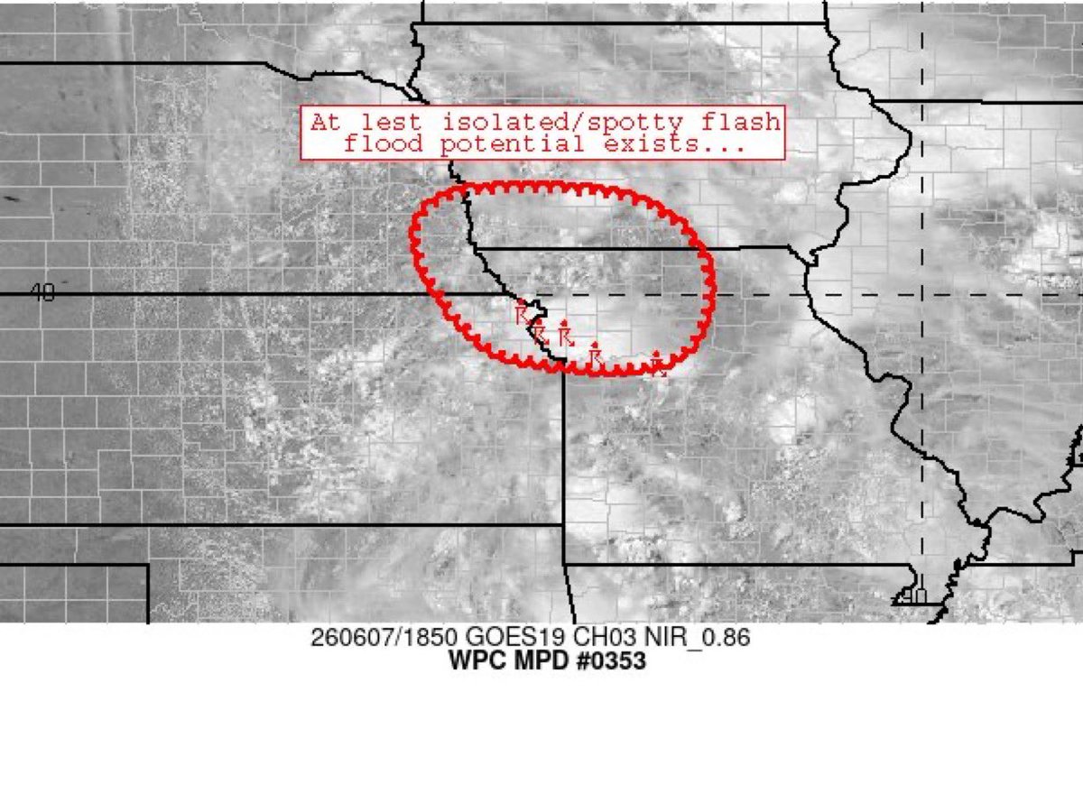
The National Weather Service has issued a Flood Watch for much of central, southern, and eastern Iowa as multiple rounds of thunderstorms are expected to move across the state today, tonight, and into Thursday morning.
Heavy rainfall may lead to localized flash flooding, especially in areas that see repeated rounds of storms. Low-lying roads, creeks, streams, and other flood-prone locations could quickly become flooded if heavier rain develops over the same areas.
Some locations could receive several inches of rain by Thursday morning, with the greatest flood threat occurring where storms repeatedly track over the same area.
In addition to the flooding threat, severe thunderstorms capable of damaging winds, large hail, and tornadoes remain possible today and tonight.
3
12
1,648
Jun 10
A few rounds of thunderstorms are expected across parts of Iowa today and tonight, and some of these storms could become severe. We are closely monitoring ongoing thunderstorm development this morning across Nebraska, Kansas, Missouri, and western Iowa, as these storms may play an important role in how the severe weather threat evolves later today.
Thunderstorms are already developing across portions of western Iowa this morning and may continue to expand and move east-northeast through the day. Some of these storms could produce severe weather, including large hail and damaging wind gusts. In addition, any lingering clouds or outflow boundaries from these storms may help determine where stronger storms develop later this afternoon and evening.
Additional thunderstorms are expected to develop later this afternoon (after 3-4PM) along an advancing cold front as the atmosphere becomes increasingly favorable for severe weather. Any storms that form initially and remain isolated will have the greatest potential to produce large to very large hail and a few tornadoes, some of which could become strong.
As the evening progresses (7-11PM timeframe), storms are expected to grow and merge into larger clusters or a line, causing the threat to shift toward damaging wind gusts. Even as storms organize into a line, an embedded tornado threat may continue, especially where favorable wind shear and storm interactions persist.
1
1
31
2,043
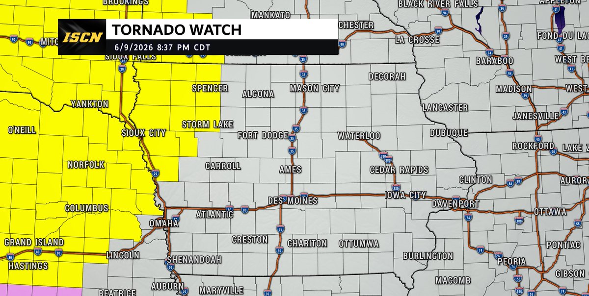
Jun 10
A Tornado Watch has been issued for northwest Iowa until 3:00 AM Wednesday as severe thunderstorms move into the area tonight.
Storms will be capable of producing large hail up to 2 inches in diameter, damaging wind gusts up to 75 mph, and a few tornadoes, including the potential for a strong tornado.
If you are in the watch area, make sure you have multiple ways to receive warnings overnight and keep the ISCN Weather app handy for the latest updates.
2
14
2,193
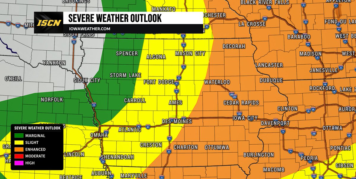
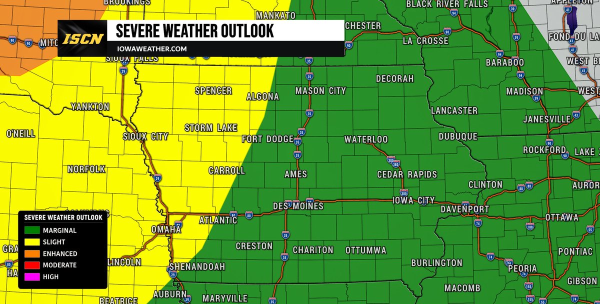
⚠️ Severe weather is possible across Iowa on Wednesday as a strong storm system moves through the region. Multiple rounds of thunderstorms may develop from the afternoon through the overnight hours, with conditions favorable for severe storms.
All hazards will be possible, including tornadoes, large to very large hail, and damaging wind gusts that could exceed 75 mph. Some tornadoes could be strong if discrete supercells develop ahead of any storm lines.
Forecast details will continue to be refined, so stay weather aware, have multiple ways to receive warnings, and check back for updates throughout the day.
#IAwx #IowaWeather #severeweather
8
43
3,917
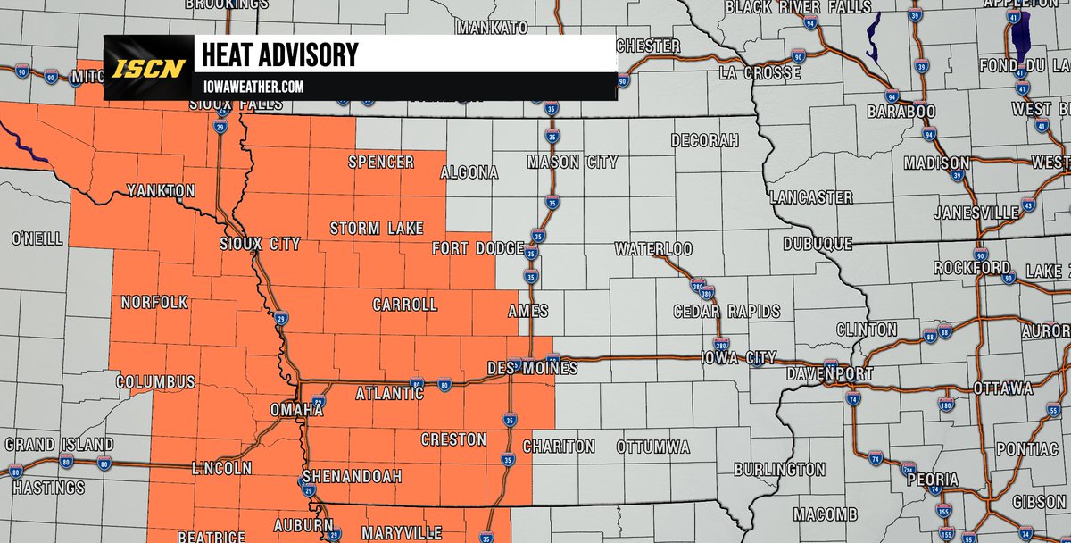
The first significant heat event of the season is expected across Iowa on Tuesday, and a Heat Advisory has been issued for much of central, western, and southwest Iowa from 1 PM to 9 PM.
Afternoon temperatures will climb into the lower to middle 90s, but high humidity will make it feel even hotter. Heat index values between 100° and 105° are expected across many areas, with a few locations potentially reaching 107°.
2
17
1,786
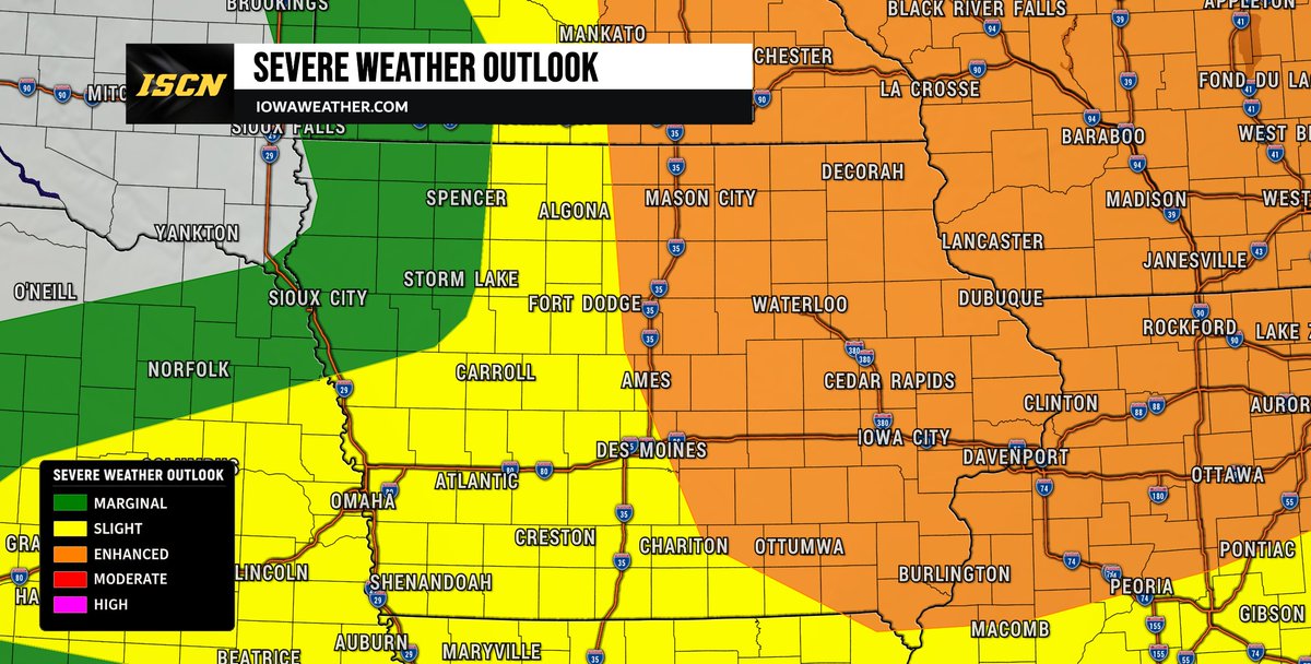
TUESDAY SEVERE THREAT: The Storm Prediction Center has expanded the Slight Risk (Level 2 of 5) farther east into portions of west-central and northwest Iowa in their latest update issued Monday afternoon.
The reason for the expansion is increasing confidence that thunderstorms developing across Nebraska, South Dakota, and North Dakota Tuesday afternoon and evening could organize into a larger complex of storms and track into parts of northwest Iowa Tuesday night.
While the greatest severe weather threat is expected to remain well north of Iowa across the Dakotas and Minnesota, storms moving into northwest Iowa could still produce damaging wind gusts and some hail. The primary concern appears to be a strengthening cluster of storms that develops farther west and tracks southeast during the overnight hours.
We'll continue to monitor forecast trends and provide updates as new information becomes available. Be sure to check back throughout Tuesday as we get closer to the afternoon and evening hours for the latest forecast updates and any changes to the severe weather threat.
#iawx #iowaweather #severeweather #weatherupdate
2
27
2,722