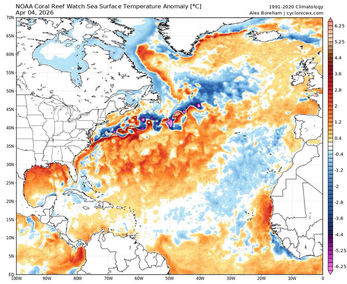
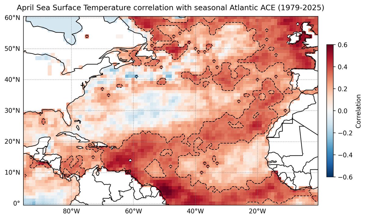
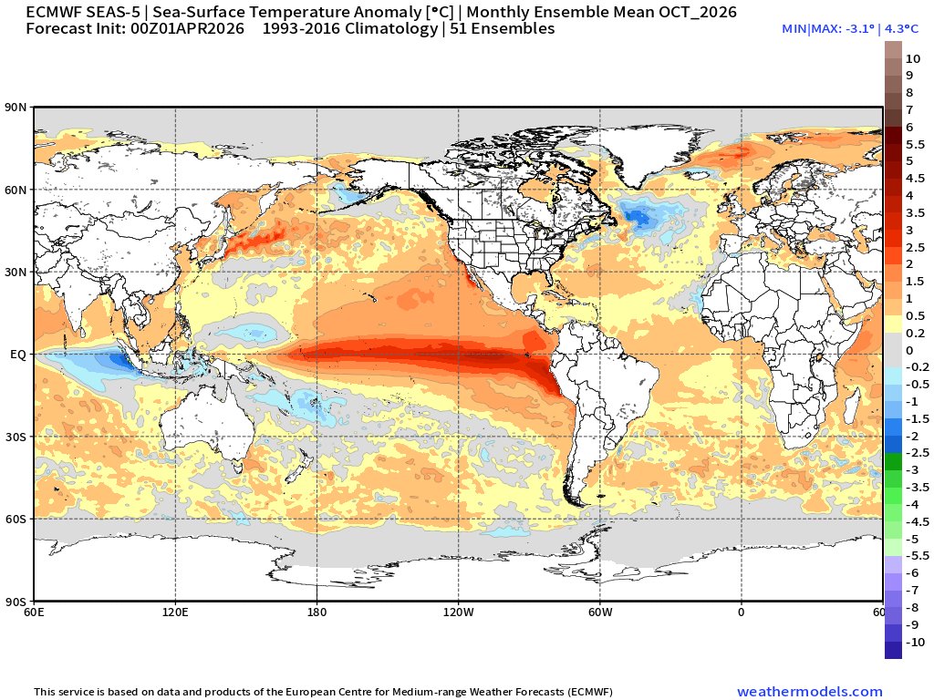
The Japan Meteorological Agency warns of an increased risk of a magnitude 8.0 earthquake within the next week and is urging people to evacuate now. #tsunami
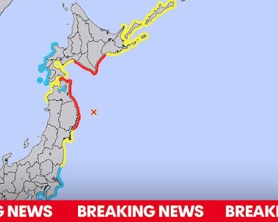
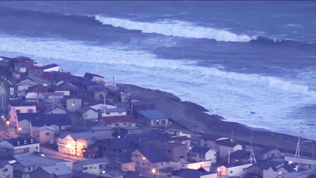
ALT TSUNAMI ADVISORY
A strong earthquake struck northern Japan, triggering tsunami warnings and evacuation orders. Although the tsunami waves were small and caused little damage, experts say there is a slightly increased risk of another, larger earthquake in the coming days.
A magnitude 7.7 earthquake hit northern Japan, prompting tsunami warnings and temporary evacuations along coastal areas. While the immediate impact was limited, authorities have warned of a slightly elevated risk of a magnitude 8.0 or greater earthquake within the next week and advised residents to remain prepared.
The Japan Meteorological Agency (JMA) says there is a slightly increased risk of a “megaquake” (magnitude 8.0 ) in the next week. The probability is still very low (about 1%), but higher than normal. Experts also warn that aftershocks or another earthquake may occur in the coming days. This is a precaution, not a prediction of a definite second quake.
A #tsunami warning has been issued for Iwate and Hokkaido downgrade following a powerful earthquake off the northeastern coast of Japan, triggered off the east coast of Honshu.
Super #Typhoon#Sinlaku slams Saipan with destructive winds and blinding rain.
Conditions are rapidly deteriorating as this powerful storm batters the Northern Mariana Islands.
#Typhoon#Sinlaku is beginning to lose some of its punch, weakening to a Category 4 storm as it moves past the Northern Mariana Islands. Satellite imagery shows a fading eye and warming cloud tops—but it remains a large and dangerous typhoon.
ALT Typhoon Sinlaku (04W) has rapidly weakened into a Category 4 equivalent system, with maximum sustained winds around 130 mph (210 km/h), as it passed just north-northwest of the Northern Mariana Islands.
Infrared satellite imagery shows that while Sinlaku remains a powerful and well-organized typhoon, its structure has begun to degrade. The once well-defined eye has become less distinct and partially cloud-filled, and cloud tops near the core have shown slight warming, indicating a reduction in convective intensity.
Despite this weakening trend, deep convection continues to wrap around the center, and the system still maintains a large, symmetric circulation with strong bands extending outward. The observed changes suggest that Sinlaku may be undergoing an eyewall replacement cycle or encountering less favorable environmental conditions, such as increasing wind shear or cooler sea surface temperatures.
#Typhoon#Sinlaku is tracking generally west-northwest toward the Northern Mariana Islands at landfall, where significant impacts are expected, including destructive winds, heavy rainfall, storm surge, and dangerous seas with 145mph and a central pressure of 930 mb.
ALT Sinlaku is tracking generally west-northwest toward the Northern Mariana Islands at landfall, where significant impacts are expected, including destructive winds, heavy rainfall, storm surge, and dangerous seas . The storm’s structure and intensity highlight an environment of near “ideal” conditions for tropical cyclone development, with a well-defined eye and strong outflow aloft.
The infrared presentation shows a compact but powerful eyewall, with cloud-top temperatures reaching extremely low values, a sign of vigorous updrafts. Spiral rainbands extend outward, feeding the core and covering a broad area, while typhoon-force winds extend tens of miles from the center.
Overall, Sinlaku is a textbook example of a high-end super typhoon, exhibiting exceptional organization, explosive intensification, and a classic satellite appearance associated with the most intense tropical cyclones on Earth.
#TyphoonSinlaku is currently located east-southeast of Guam and is moving generally northwest toward the Mariana Islands. It has reached super typhoon strength, featuring a well-defined eye surrounded by intense deep convection and a tightly organized CDO structure.
ALT The latest satellite analysis, the system has reached super typhoon strength, featuring a well-defined eye surrounded by intense deep convection and a tightly organized central dense overcast structure.
The cyclone is currently located east-southeast of Guam and is moving generally northwest toward the Mariana Islands. Environmental conditions remain highly favorable for a strong system, including very warm sea surface temperatures, low vertical wind shear, and efficient upper-level outflow, which have supported rapid intensification.
The storm poses a significant threat to the Northern Mariana Islands, including Saipan and Tinian, with hazards including destructive winds, torrential rainfall, storm surge, coastal flooding, and dangerous sea conditions. Forecast guidance suggests gradual weakening after peak intensity as the system tracks northwest and encounters less favorable atmospheric conditions.
#SuperTyphoonSinlaku rapidly intensified into a powerful Category 5-equivalent system, with sustained winds of around of 150 knots (175mph) and a central pressure of approximately 902mb.
ALT Super Typhoon Sinlaku (04W) formed in the warm waters of the western Pacific Ocean near Micronesia. It developed under favourable conditions, including high sea surface temperatures, low wind shear, and a moist atmosphere, which allowed the storm to strengthen very quickly.
Sinlaku rapidly intensified into a powerful Category 5-equivalent system, with sustained winds of around 150 knots and a central pressure of approximately 902mb. This rapid strengthening is an explosive of rapid intensification, where a tropical cyclone’s wind speeds increase dramatically over a short period of time.
On satellite imagery, Sinlaku shows a highly organised structure with a clear, well-defined eye at its centre. Surrounding the eye is the eyewall, where the strongest winds and heaviest rainfall occur. Spiral rainbands extend outward, bringing intense rain and gusty winds to surrounding areas.
🌬 China acaba de registrar la ráfaga de viento más fuerte del año. Una supercélula arrasó el condado de Daishan, en la provincia de Zhejiang. Los vientos máximos alcanzaron la asombrosa cifra de 54,8 m/s (122 mph).
📹 @yangyubin1998
The Caribbean is slightly warmer than normal, while the eastern and central tropical Atlantic are slightly cooler than normal. This pattern of Atlantic sea surface temperatures provides mixed signals regarding the potential for an above- or below-normal Atlantic #hurricane season
#CycloneMaila is a compact but very intense Category 4 tropical cyclone located over the Solomon Sea, showing a highly organized structure.
ALT Infrared satellite imagery displays a large central dense overcast with extremely cold cloud tops, which indicates very strong thunderstorms surrounding the center. Despite its strength, Maila is being affected by moderate easterly wind shear.
This is causing the storm to tilt slightly and prevents the eye from becoming perfectly symmetrical. As a result, the cyclone appears somewhat uneven on satellite imagery.
The environment around the storm is otherwise favorable, with warm ocean waters and good outflow, helping to maintain its intensity. However, because the system is moving slowly, it may begin to churn up cooler water beneath it (a process called upwelling), which could gradually weaken the storm if it continues.
Maila’s movement is slow and somewhat erratic due to weak steering winds. This increases the risk of prolonged impacts, including damaging winds, heavy rainfall, and dangerous sea conditions for nearby islands.
New maps causing meteorologists to lose their minds in disbelief at massive heat build-up in the Equatorial Pacific
The oceans will not literally be boiling red 🔴 in the early autumn, but the Super El Niño will drive unprecedented global extreme weather events.
Post-#StormDave Final Advisory 9
Winds: 60mph
EWSIS: ex-WS
MSLP: 981mb
#Dave is currently located near or over the coast of Rexvågen, affecting southern Sweden, and has become a post-windstorm tonight. This is the last advisory. More details on image description...
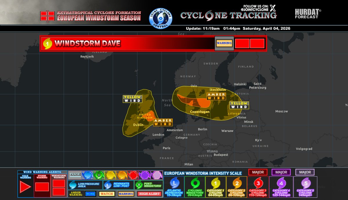
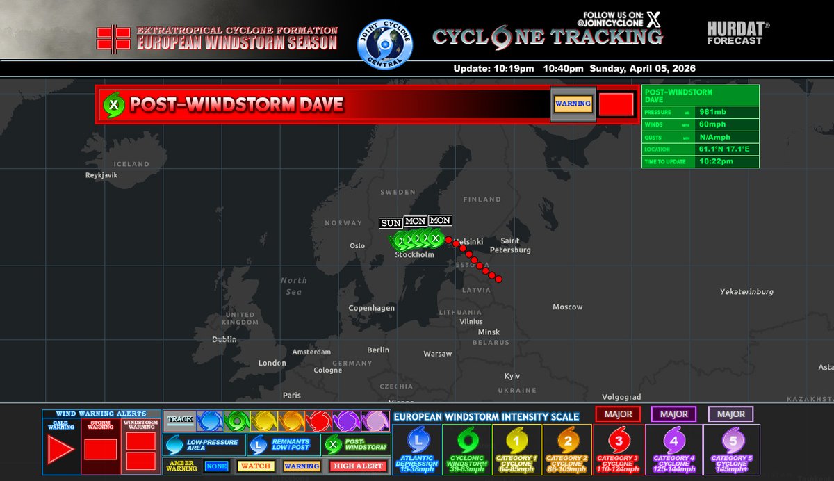
ALT The storm maintains a pressure of 981 mb and maximum wind gusts of 60 mph. While gust data is unavailable, the system continues to bring significant wind impacts to the region.
The storm's path shows that it has moved northeast from the Baltic states toward southern Finland. Meteorologists have issued a warning for the affected areas, highlighting potential hazards such as strong winds and localized damage. Residents in the storm's trajectory should exercise caution and follow local safety advisories.
Post-Windstorm Dave is classified as a post-storm system, having transitioned from a more intense phase earlier in its course.
#StormDave Advisory 8
Winds: 80mph
EWSIS: C1
MSLP: 980mb
#Dave is currently moving towards Dalarna County, Sweden, with strong winds affecting central and southern regions. More details on image description...
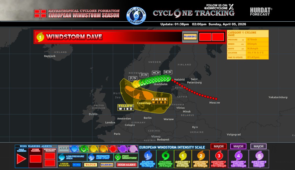
ALT Areas around Gothenburg are expected to experience significant gusts before the storm transitions into a post-windstorm phase in the next few hours.
Warnings:
Amber Wind Warning: Copenhagen region
Yellow Wind Warning: Southern Sweden
Track: The storm has been moving northeast from the Baltic Sea, with decreasing intensity projected as it moves inland.
Forecast:
Sunday: Strong winds continue along the coast and inland areas.
Monday: Transition to post-windstorm conditions, with decreasing wind speeds across central Sweden.
Impact:
Residents should prepare for potential travel disruptions, downed trees, and power outages in affected areas.
Note: This storm is part of the European Windstorm Season and is monitored closely for any changes in track or intensity.
#StormDave Advisory 7
Winds: 80mph
EWSIS: C1
MSLP: 979mb
Dave is currently affecting the region, with the storm system expected to gradually weaken as it moves northeastward across Rudssætra, Norway...
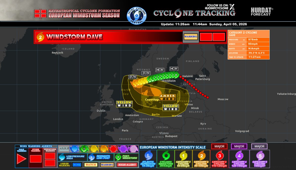
ALT Dave is currently moving through the region toward Rudssætra, Norway. While it is expected to bring strong winds and affect northern Denmark and southern Sweden, the storm's intensity is expected to gradually diminish as it progresses northeastward.
As the storm moves northeastward, it is expected to gradually weaken over the next 6 hours. By later tonight, the storm will transition into a post-windstorm phase as its intensity diminishes.
#StormDave Advisory 6
Winds: 85mph
EWSIS: C1
MSLP: 979mb
#Dave is currently classified as a Category 1 cyclone, is making its way across Europe and is headed towards Buskerud and Innlandet in Norway...
ALT Dave is currently a Category 1 cyclone with significant winds and pressure, it is expected to gradually weaken as it moves further inland. Cyclones typically lose strength once they make landfall or move away from cold waters, which are a primary energy source for their strength.
As Dave progresses through Buskerud and Innlandet, it will likely start to lose intensity. The storm could downgrade to a low-pressure system or even a remnant low in the coming days, meaning the winds will decrease in force and the overall threat will reduce. However, it may still bring strong gusts and heavy rainfall to the affected areas, particularly along the path.
It's important to keep an eye on updates as the weakening storm could still bring impacts such as localized flooding or disrupted travel. By Monday, the storm will likely be a much weaker system, but the wind warnings could persist in some areas until it fully dissipates.
#StormDave Advisory 5
Winds: 90mph
EWSIS: C2
MSLP: 978mb
#Dave is currently moving toward Norway, bringing damaging gusts, heavy rain, snow, and coastal flooding to areas in southern Norway and northern Denmark today, with the storm expected to gradually weaken later...
#StormDave Advisory 4
Winds: 100mph
EWSIS: C2
MSLP: 972mb
#Dave is currently tracking toward the northeastern coast of Europe. The storm is moving toward the North Sea and is likely to affect the coastal regions of northern Germany, Denmark, and possibly the Netherlands...
#StormDave Advisory 3
Winds: 90mph
EWSIS: C2
MSLP: 974mb
#Dave is expected to track across North Sea, strengthening as it moves toward Scandinavia. Increasing winds & coastal impacts are likely from late Sunday into Monday, particularly across southern Norway, Denmark, and Sweden
#StormDave Advisory 2
Winds: 85mph
EWSIS: C1
MSLP: 978mb
#Dave is expected to move northeast across Northern Scotland tonight, bringing moderate to strong winds, especially across the UK and parts of northern mainland Europe from Easter Sunday into Monday...
#StormDave is impacting parts of northern and western Europe, bringing widespread strong winds and hazardous conditions from Saturday night into Easter Sunday.
Overall, this windstorm represents a moderate to high-impact event, with conditions gradually improving as the system tracks further into northeastern Europe.