
20,304 Photos and videos


Update: The tornado threat for today has increased, especially near the IL border where a few strong tornadoes, EF-2 strength or higher, are possible. The flooding threat has decreased with the storms expected to move quickly. Brief urban flooding is still possible.
1
4
689
9:45 AM Radar: Quiet in SE WI now. A tornado watch (yellow) is in effect for parts of IA & IL until 3PM. Lots of severe thunderstorm warnings along that line. If it holds together it would impact some of our southern counties near the IL border shortly after noon.
1
2
351
UPDATE: The Storm Prediction Center has now placed all of northern IL, parts of eastern IA and some southern WI counties near the IL border In a Level 4 Moderate Risk. The strong tornado (EF2 ) and damaging wind threat in these areas has increased.
1
1
194
Hunter & Hercules are our featured pets today! Highs hover around 80 this afternoon with lots of humidity. Get the long dog walks in this morning before showers and storms start around midday. Severe storms arrive after 3 PM.
5
118
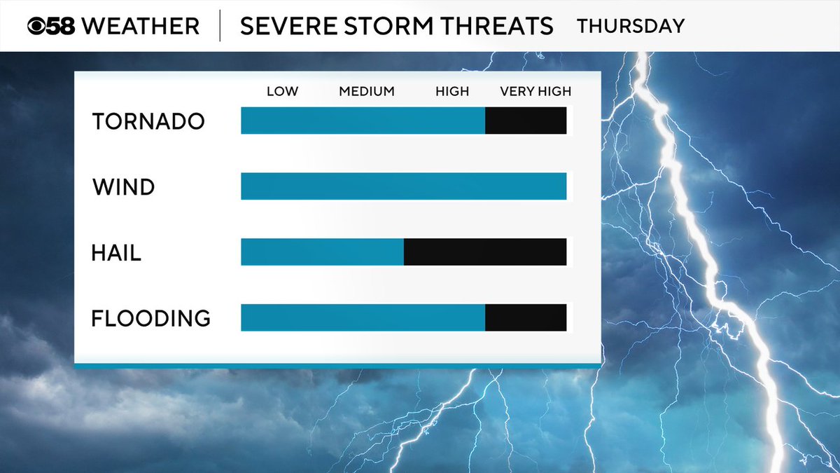
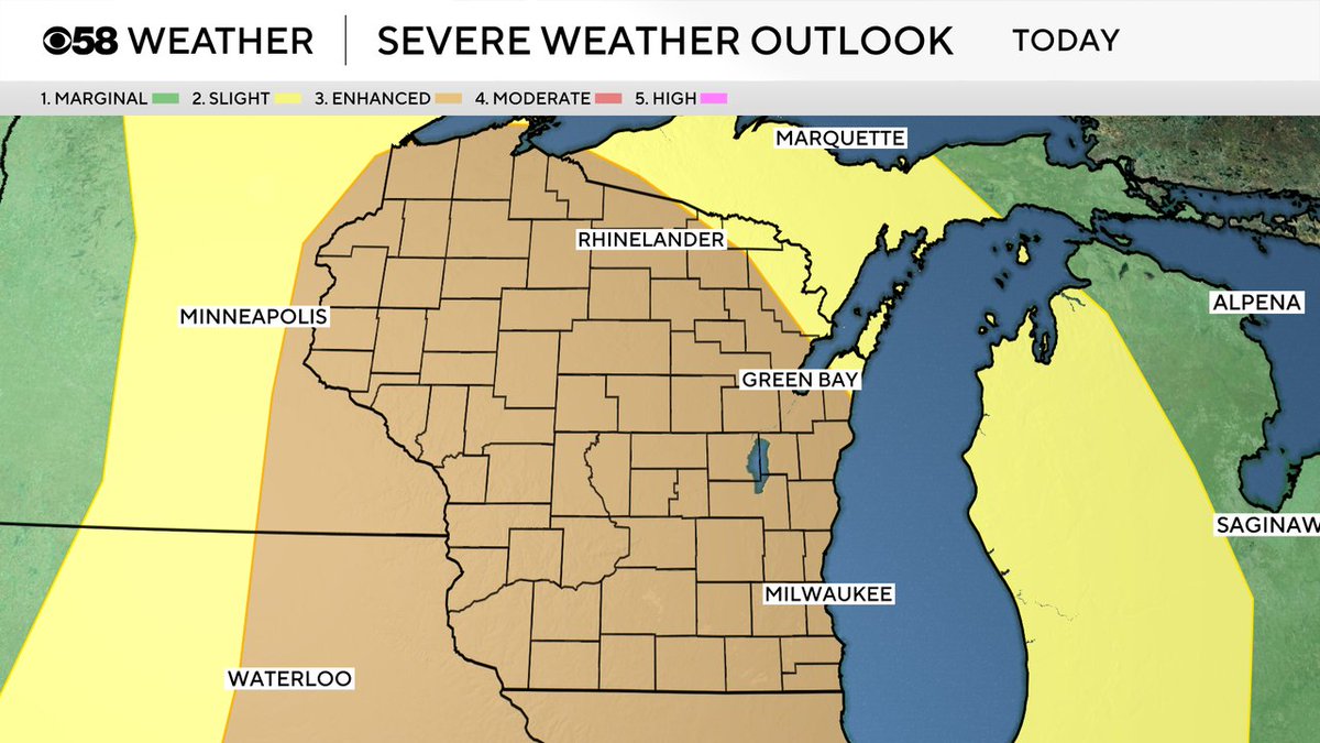
All of southeast Wisconsin is now under the Level 3 Enhanced Risk for severe weather. The best timing for severe storms will be from 3-9 PM. The tornado threat is higher than yesterday. Damaging wind and flash flooding are also possible along with some hail.
1
156
There were over 500 severe storm reports across the Midwest yesterday and dozens in our local area. Here we are highlighting some of the strongest wind reports. 94 mph in Oshkosh! 85 mph in Rockdale! 75 mph in Fort Atkinson! 73 mph in Beaver Dam!
2
267
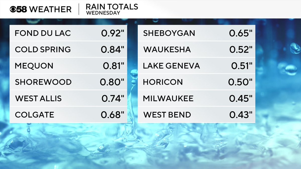
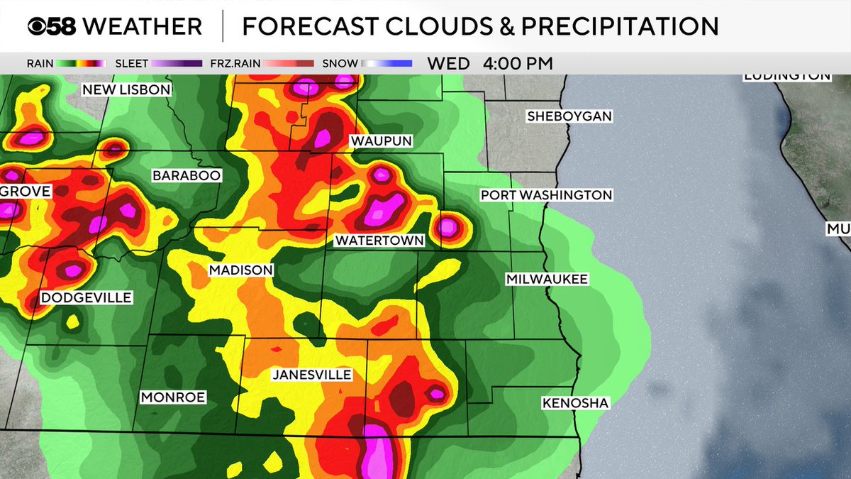
The severe storms Wednesday moved through pretty quickly so rain totals stayed manageable with 0.25-1" of rain possible. Heavier rain is possible with the storms today.
1
133
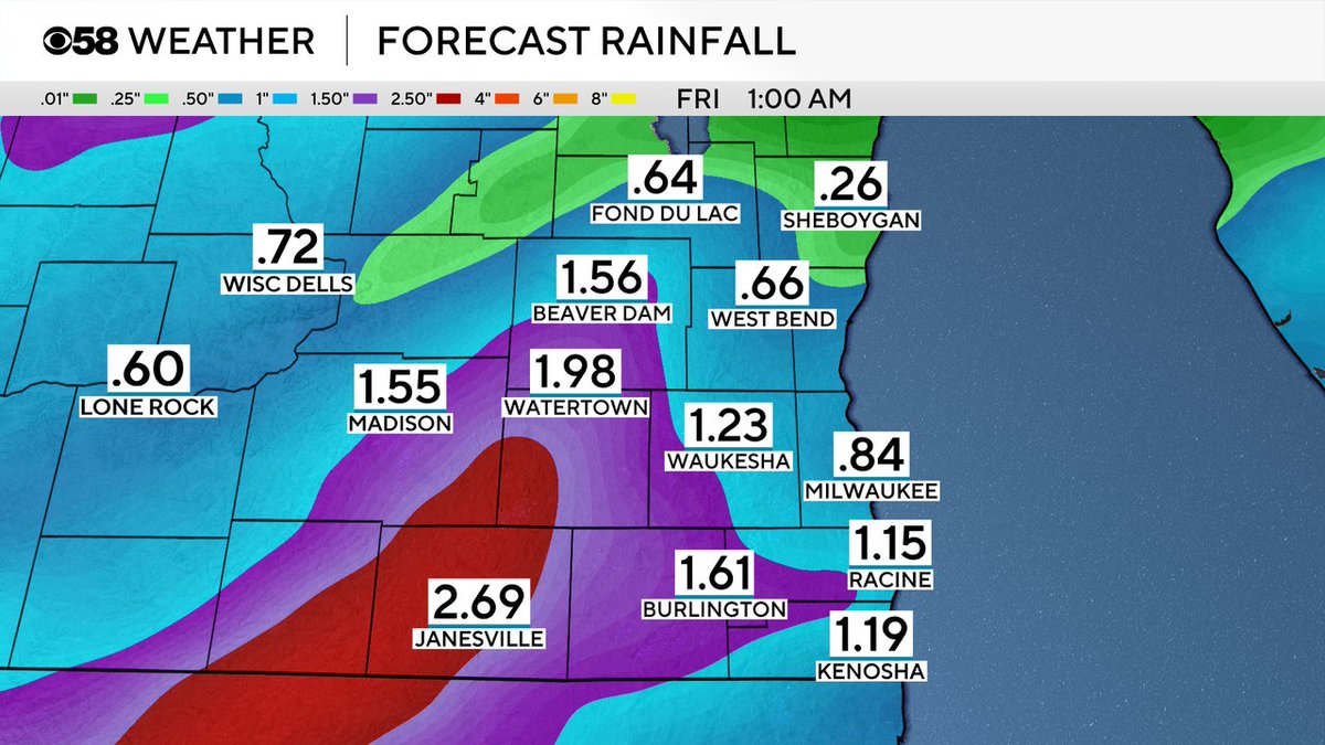
Storms today could bring more heavy rain than yesterday, but will heavily depend on where the strongest storms set up. Up to 2" of rain will be possible in the strongest storms while others get only a quarter or half inch of rain that see just rain or a few light storms.
2
259
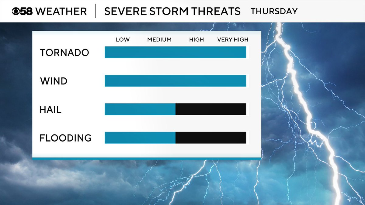
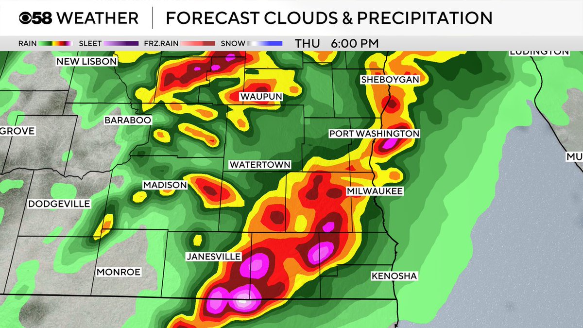
All severe threats are on the table again for storms Thursday afternoon/evening. The tornado and flooding threat is a bit higher than Wednesday but damaging wind remains the primary threat. Some hail is also possible.
2
161
We start dry today then a few showers and storms are possible around lunch time. Widespread severe weather is not expected during that first round but more storms after 3 PM are possible through 10 PM when the severe window is greatest (shown here).
1
124


Justin Thompson-Gee retweeted

Jun 10
2
2
10
401
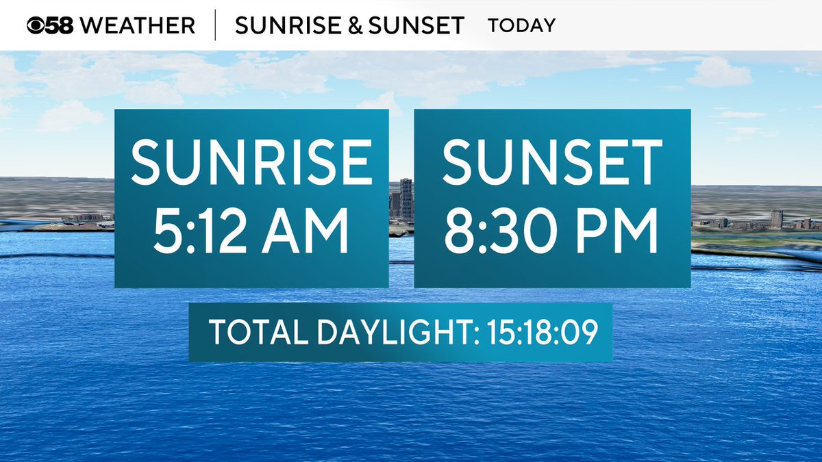
Interrupting your storm posts to announce that the sunset tonight is at 8:30 PM. It only stays later than 8:30 PM for a few weeks until sunset starts to get earlier and earlier after the solstice on June 21st.
1
2
6
312
The strong to severe storms today and tomorrow will be very efficient rain makers. A soaking 0.50-1.50" of rain is possible with storms Wednesday. Thursday's storms could bring even heavier rain pushing rainfall totals between 2-4" for southeast Wisconsin by the time storms end.
1
1
147
Saint is our featured pet today! After some morning fog we are pretty dry for the morning dog walks and even lunch dog walks but severe storms are likely later this afternoon/evening so get the long walks in early. Warm and very humid with feels like temps in the 90s.
5
120
All of southeast Wisconsin, and almost all of the state of Wisconsin, remains under a Level 3 Enhanced Risk for severe storms today. Any storms that form will likely be strong to severe.
1
4
205
High temperatures and peak feels like temps will all depend on when afternoon storms arrive. Most of us see highs in the upper 80s with dew points in the low 70s pushing feels like temps into the upper 90s in some areas.
1
3
224
Damaging wind will be the biggest threat with any severe storms today but a few tornadoes are possible. Flash flooding and wet basements are a decent threat but might be worse Thursday. Some hail is also possible.
1
3
151
We should stay mostly dry this morning with a cluster of storms staying to our north. The better chance for storms starts after 2 PM and lasts through the late evening. Strong to severe storms are likely.
1
2
126
Th rain from Monday into Tuesday saw the heaviest downpours in western counties where some saw over an inch. Much less in lakeside communities where totals were generally under a quarter inch and some only saw a few hundredths.

3
262