
Joined April 2017
- Tweets 2,290
- Following 77
- Followers 255
- Likes 38
281 Photos and videos


KY Climate Center retweeted

Jun 12
🌬️All-time maximum wind gust: 61 mph (4/4/2021) Monthly climate summaries for all 87 sites can be found on this link: kymesonet.org/data/summary/F… #kywx
2
2
439
KY Climate Center retweeted
Jun 12
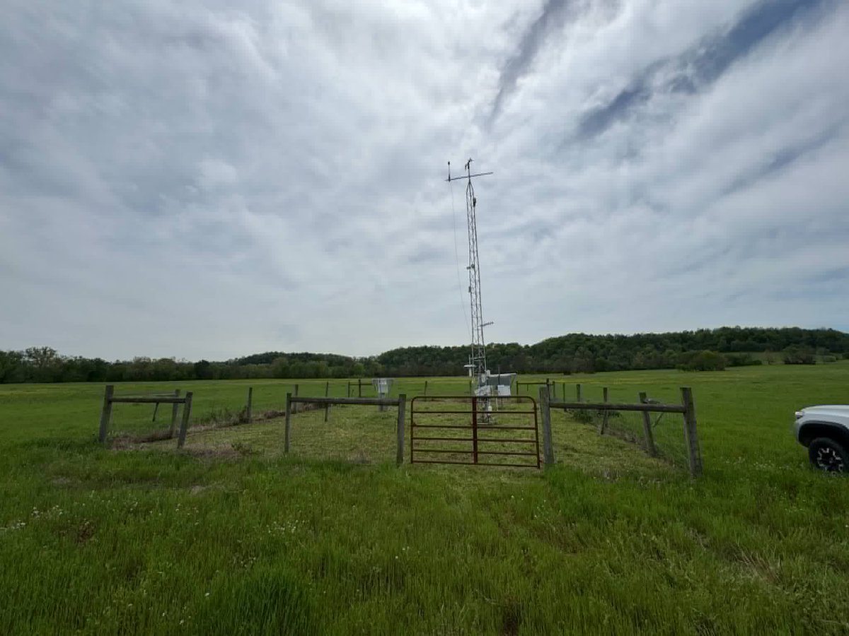
🧵Site of the Week: Cumberland County (3 mi W of Burkesville)
✅First online: 6/11/2009
🔴All-time maximum temp: 105F (6/29/2012)
🔵All-time minimum temp: -21F (2/19/2015)
🟢All-time maximum dew point: 83.2F (7/25/2021)
⛈ All-time maximum 24-hour precipitation: 5.66" (8/18/2010)
1
2
3
354
KY Climate Center retweeted
Jun 11
As the old saying goes, "it's not the heat, it's the humidity"! Dew points, which measure the amount of moisture in the air, are running mainly in the 70s this afternoon. Combine these temperatures with air temperatures and heat indices are > 100F at many locations. #kywx

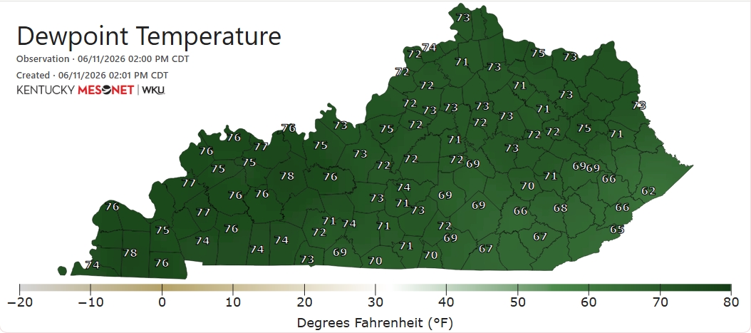

1
4
8
566
Additional rain is expected across the region as a cold moves through. Rivers in the western basin are rising in several locations with some expected to reach flood stage. Any rises in the east will be flashy and short lived.
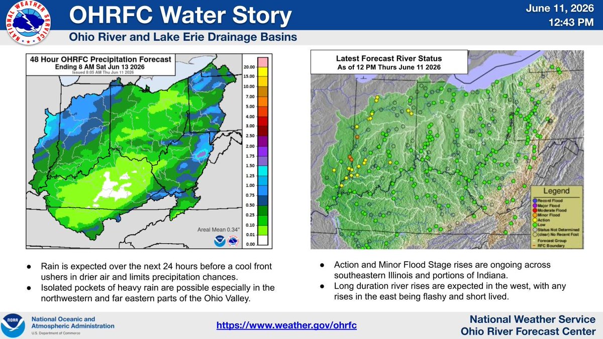
ALT Left image shows the 48 hour rainfall forecast from OHRFC. Right image shows the resulting river forecasts from the noted rain forecast.
2
1
121
KY Climate Center retweeted
Jun 11
However, many sites in the east show water fraction by volume < 20%.
This week's update does not take into account any rain that has fallen since 8am ET/7am CT Tuesday, the cutoff time for data to be ingested and tabulated for the Drought Monitor. #kywx
1
1
170
KY Climate Center retweeted
Jun 11
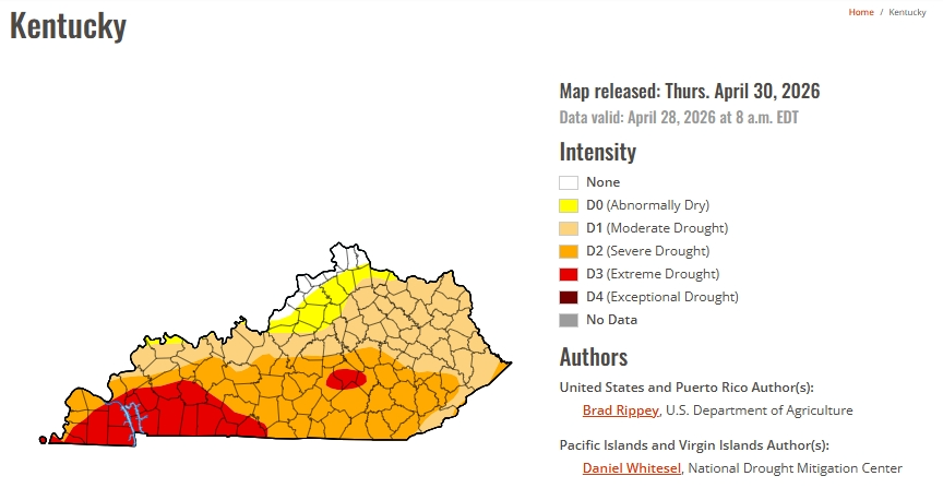
There are still pockets of D2 ('Severe Drought') and a couple of areas of D3 ('Extreme Drought') in portions of south-central and eastern KY.
A check of average soil moisture at a 4" depth since Monday reveals that more adequate moisture has returned to the topsoil for many.
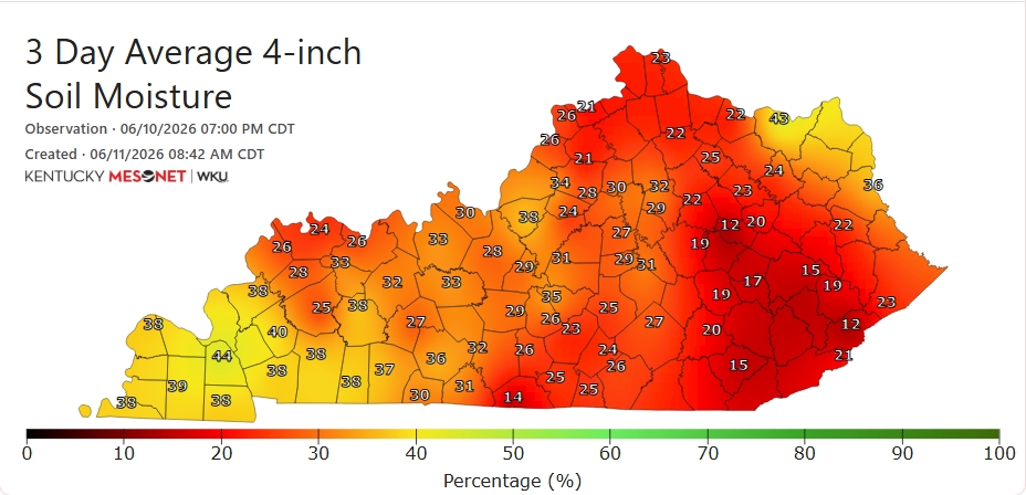
1
1
3
184
KY Climate Center retweeted
Jun 11
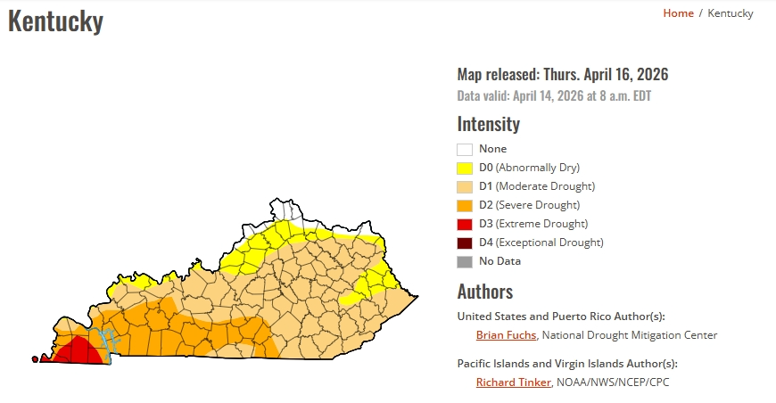
🧵This morning's U.S. #DroughtMonitor from National Integrated Drought Information System (NIDIS) has been released. It shows a bit more improvement with the percentage of the Commonwealth officially in drought at 56%, down roughly 13% from a week ago.

1
3
6
434
KY Climate Center retweeted
Jun 10
🥵It's that time of year again! The combination of higher temperatures and humidity levels is resulting in triple-digit heat indices in parts of the state today, especially in the western region. Stay hydrated! #kywx

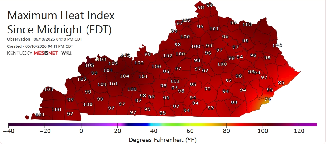
1
6
337
Additional rain is forecast for parts of our area over the next two days. Highest totals are expected in our northwest and eastern areas (1-2"), and heavier amounts (up to 3-4") are still possible. Some rivers in IL, IN, and KY are forecast to reach action stage or higher.

ALT Left image: Shades of green, blue, and purple illustrate the two-day OHRFC precipitation forecast across the OHRFC area of responsibility. Right image: green, yellow, and orange dots highlight river forecast points and their latest forecast river status across the OHRFC area of responsibility.
3
1
114
KY Climate Center retweeted
Jun 10
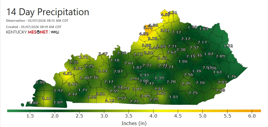
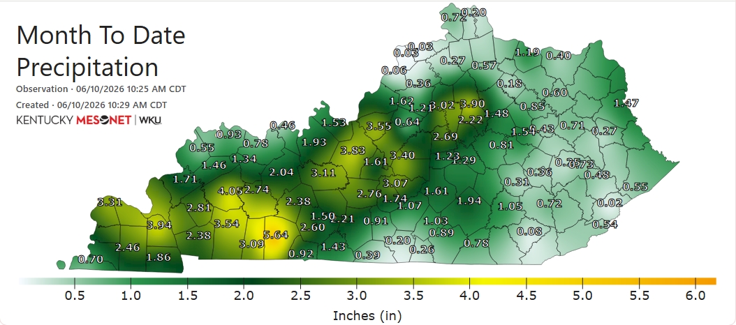
The southern Pennyrile region also picked up some heavy rainfall. Logan County near Russellville leads the way with > 5" of rain since June 1.
Maps for precipitation along with several other weather parameters can be found here: kymesonet.org/.../ufHqh_pQ/A… #kywx
2
1
427
KY Climate Center retweeted
Jun 10
🧵🌧️Here's a check of rainfall amounts from the past two days, three days, and the month of June so far. Generally speaking, the most significant totals from the early week rains fell from the Jackson Purchase region eastward to near Lexington.

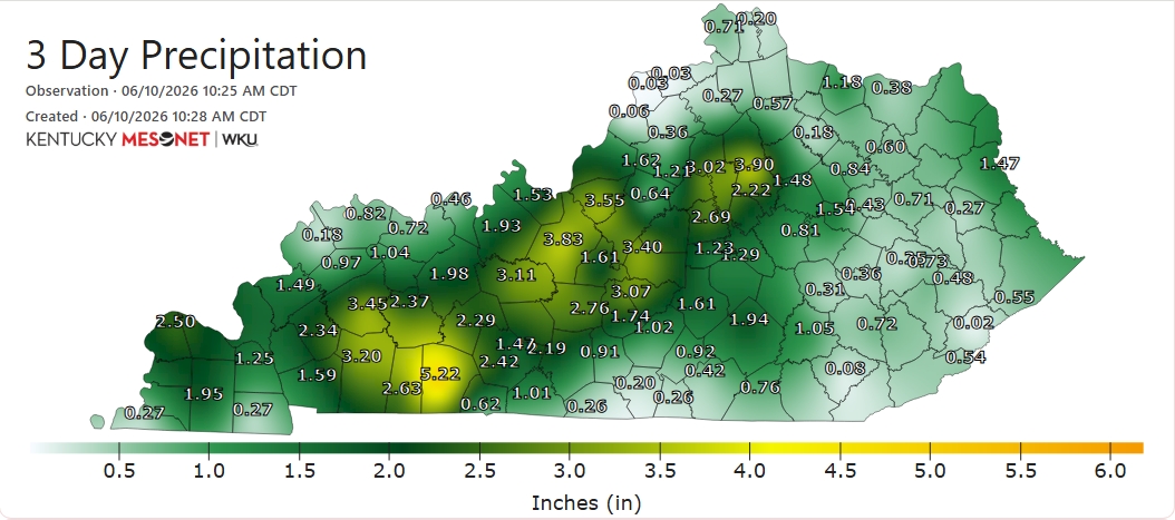
1
3
4
450
KY Climate Center retweeted
Slow-moving storms are drenching portions of north-central KY eastward into the Blue Grass region at midday Tuesday. Upwards of 3" of rain has fallen at our N Fayette Co. station at the UK Spindletop Farm just within the past three hours! #kywx

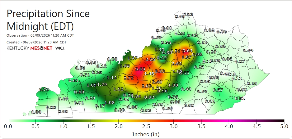
2
6
429
KY Climate Center retweeted

Jun 8
Tis the season of the heat index 🌡️
Our heat index probability curves now include the latest data through 2023! All the more reason to understand how to read our probability curves at different thresholds.
Check your location here ➡️mrcc.purdue.edu/clim/heatInd…

1
1
213
KY Climate Center retweeted
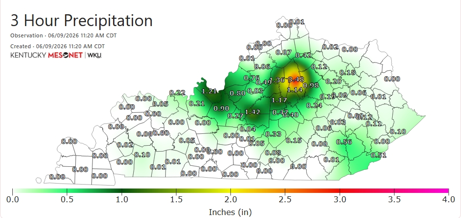
👀🌧️The U.S. 68/80 corridor from roughly Hopkinsville east to Bowling Green has been the big winner in the rain department thus far today! #kywx

1
2
203
Rain is forecast over the next 7 days, with heavier amounts expected in the western portion of the basin. Rain forecast for the next 10 days is expected to extend current elevated river levels and could cause additional action stage or minor flooding in the west.

ALT The left image shows the 7 day precipitation forecast with colors of blue through red showing forecast precipitation levels. The right image shows the potential river levels across the Ohio Valley in dots and squares ranging in colors from green to orange, representing flood levels.
1
1
116
KY Climate Center retweeted
After a 1st week of June that was dry for many, significant, widespread rainfall has returned. The heaviest rains today will occur in the west & central, where a Flood Watch is in effect. Already up to 2" of rain has accumulated at our site in Christian Co. since midnight! #kywx
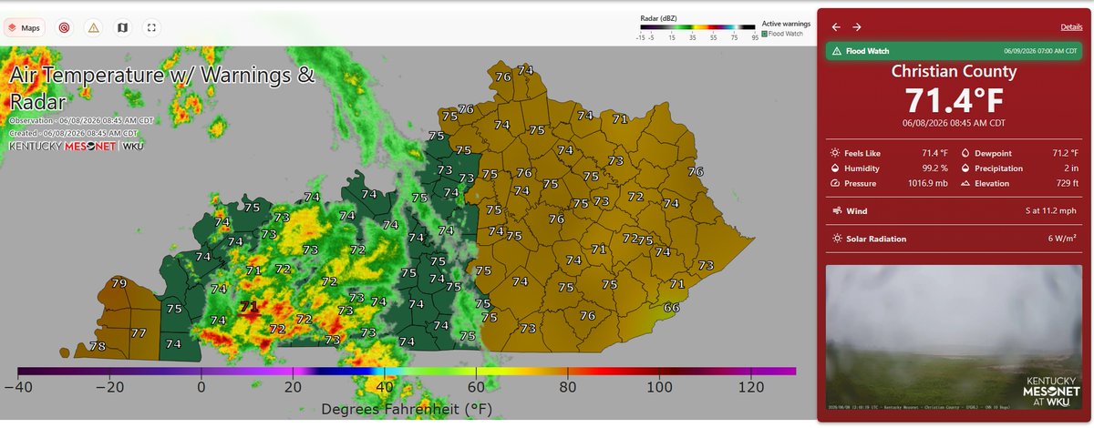
2
3
311
KY Climate Center retweeted
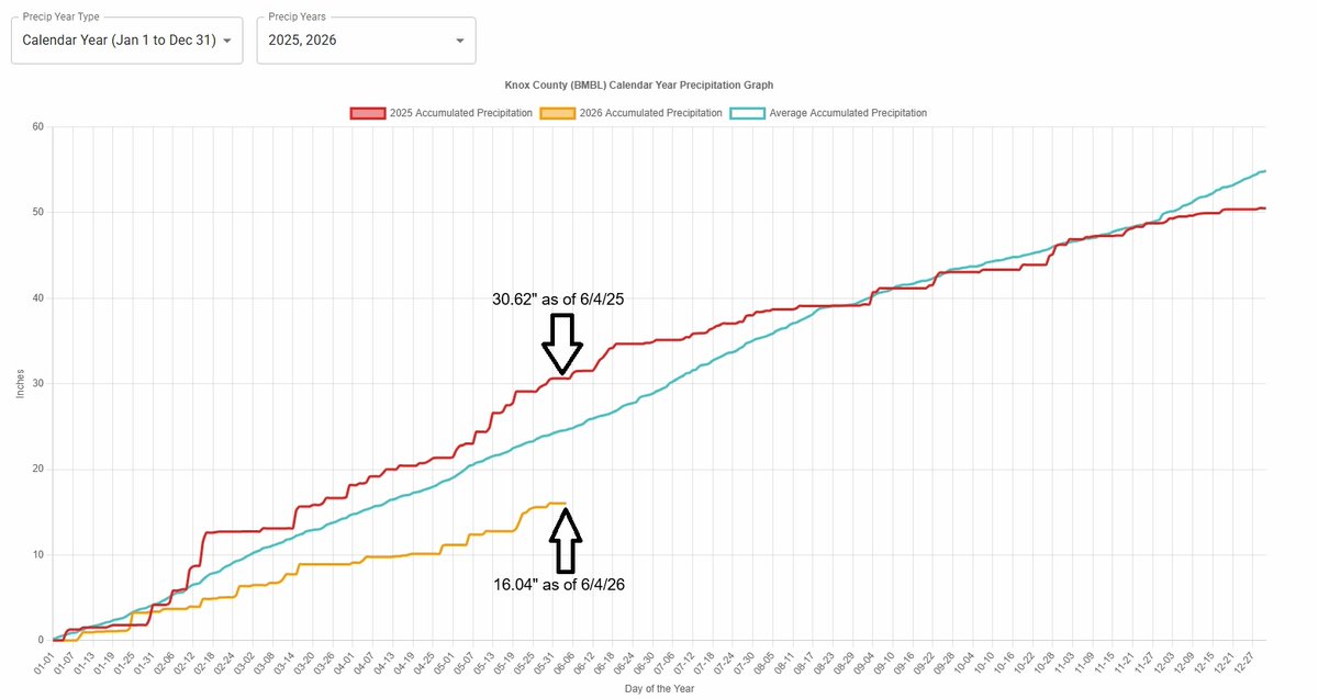
Note the average rainfall (cyan color) shows that normal yearly rainfall-to-date for both sites to date is ~ 25".
Customize your precipitation graphs for multiple years at various stations under the 'Mesonet Climate' tab on the Kentucky Climate Center website! #kywx
1
1
166
KY Climate Center retweeted
So far in 2026, our Fulton Co. site near Hickman has picked up less than half of the precip it had received by this point in 2025. In Knox County near Barbourville, just over 16" of precipitation has accumulated so far this year, more than 14" shy of last year's total to date.
1
1
1
175
KY Climate Center retweeted
🧵Compare & Contrast: Total precip for 2026 continues to lag well behind what many across the state had received by this same date a year ago.
These two graphs pulled from our @kyclimate webpage for Fulton Co. in the west and Knox Co. in the east illustrate the difference well.

1
1
6
248

Happy Thursday everyone,
This is a friendly reminder of our monthly climate webinar TODAY at 2pm ET / 1pm CT. Details below.
Zoom link: wku.zoom.us/j/94568216001...
YouTube Channel: youtube.com/channel/UCDg3h8l…
Hope you can join us! #kywx
1
34