
No Service like the Fire Service
Joined September 2012
- Tweets 2,529
- Following 367
- Followers 346
- Likes 11,722
505 Photos and videos


Mike Loos retweeted

Mar 21
ADVISORY: OPP is requesting the public shelter in place in the area of Rankin Bridge Road in the Sauble Falls area. Officers are responding to an active incident in the area. Please remain indoors with doors and windows locked and stay away from the area until further notice. Further information will be provided when available. ^pia
#GreyBruceOPP

5
26
45
16,506
Mike Loos retweeted

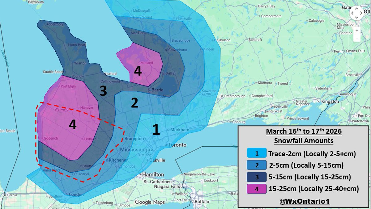
Mar 16
Another Lake Effect Snow Event is on the way to parts of the Southern #Ontario Snowbelts ❄️😮💨
- Strong squalls are expected to develop this evening and continue into Tuesday PM
- Hardest hit area will likely be #Bruce/ #Huron and #Perth Counties where heavy snow and Blizzard Conditions (Red Dashed) are possible tonight into tomorrow (Zone 4)
- Some uncertainty remains for Zone 4 SE of #GeorgianBay where lower amounts are possible (5-15cm) as there is still quite a bit of ice cover which may limit the full LES potential
- A general 5-15cm is expected across Zone 3 with locally higher amounts possible if a band "locks in"
- Closer to the #GTA, Trace to 2cm with as much as 5cm is possible, locally
- Strong wind gusts will be the greatest concern with gusts in the 60-80 km/hr range from around midnight to near noon
- Visibility will be near to completely zero at times due to blowing/ drifting snow across rural areas
- Road closures are possible/ likely
Hopefully this is the last Lake Effect Snow Forecast of the season...
#OnWX #ONStorm
2
5
40
5,636
Mike Loos retweeted

Brockton has announced the retirement of Deputy Fire Chief Glen Wilhelm.
cknxnewstoday.ca/midwestern/…
1
1
461
Mike Loos retweeted
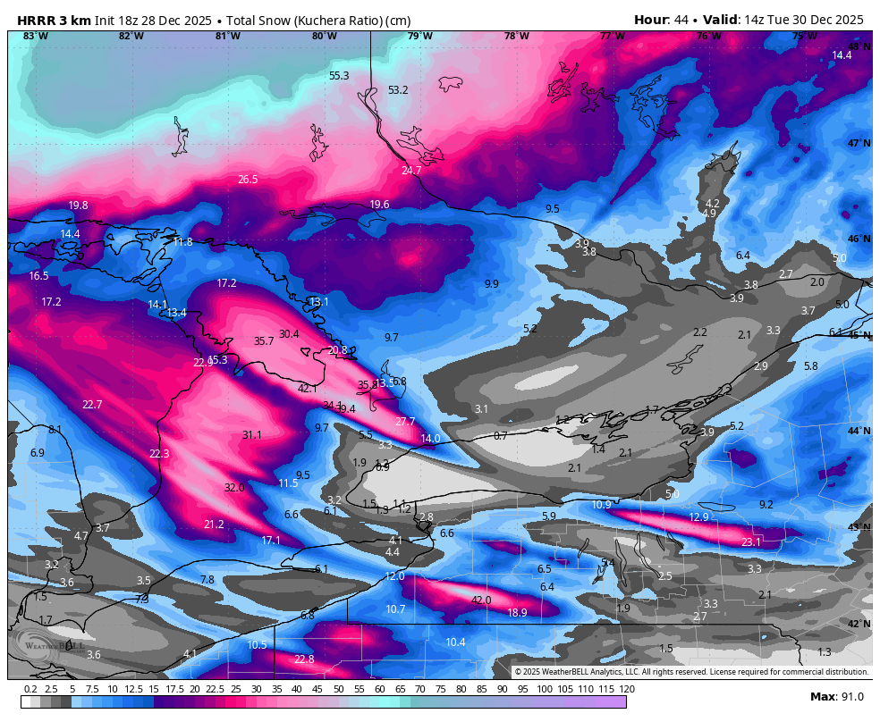
28 Dec 2025
BLIZZARD CONDITIONS are all but certain across #Huron/ #Perth/ #Grey/ #Bruce and Northern #Middlesex Counties tomorrow
Conditions will deteriorate through the morning
Many roads in the afternoon/ evening may become impassable as plows won't be able to keep up
Good day to stay home if you can and avoid non-essential travel
Heavy snow with strong winds will lead to significant blowing/ drifting snow
Road closures are likely
#OnWX #ONStorm
6
11
43
8,286
Mike Loos retweeted

19 Dec 2025
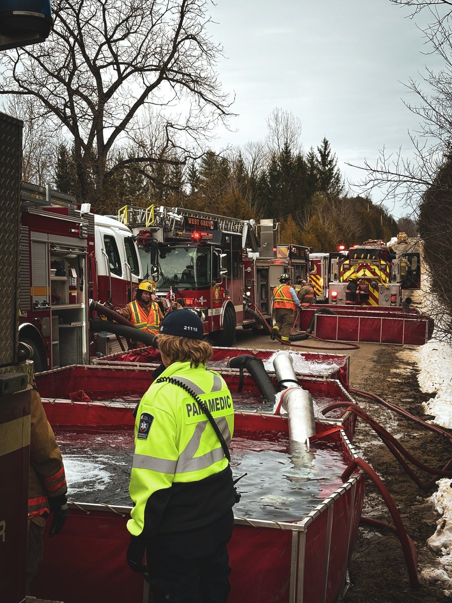
Hanover Fire responded to a barn fire on Concession 2 SDR in West Grey on Dec 19 at 10:19 a.m. Crews worked with mutual aid partners to control the fire and prevent extension. One individual was assessed on scene for minor injuries. Structure is a total loss. See full text below.
1
2
1
126
Mike Loos retweeted

12 Nov 2025
Portion Of Highway 9 Closed Following Collision bayshorebroadcasting.ca/2025…
3
1
705
Mike Loos retweeted

12 Nov 2025
Collision on #HWY9 Both Directions between County Road 20 / County Road 4, Riversdale and County Road 1 / Silver Lake Road,#Kinloss. All lanes closed. #Closure #ONHwys 511on.ca/map#SubIncidentClos…
1
937
Well, I'm sure the leafs season will continue on the with the disappointments of this loss. #usedtoit
#BlueJays #mapleleafs
4
109
Mike Loos retweeted

10 Jul 2025
We’re excited to support the Walkerton Firefighters Association with the acquisition of a new UTV fire and medical skid unit.
.
💡The next ROOTS Community Fund application deadline is August 28th, 2025. Apply now to make a difference in your community!
trilliummutual.com/roots-com…
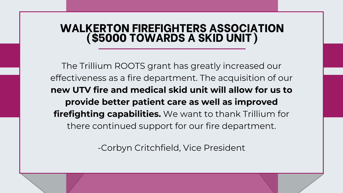
ALT Roots Community Fund Donation to the Walkerton Firefighters Association.
2
4
73
Owen Riegling made a surprise appearance at the WDCS year end memorial today. What a great gesture to close out what has been a difficult end to the school year for many. #wdcs #riverhawks #brucecounty
6
84
Thanks to @TrilliumMutual ROOTS and the Cargill District Community Fund for the donations towards the WFD UTV pump skid. Also thanks to JC Welding for donating the stainless steel support frame facebook.com/share/p/19HJCjX…
5
43

Legacy projects form as communities remember Walkerton teacher and students owensoundsuntimes.com/news/l…
3
67
A tragic day for the Brockton area yesterday with two unrelated fatal incidents. Tough times ahead for many in the community. #walkertonstrong
24 May 2025

Crash claims 5 lives in Middlesex County, including 4 teens ctvnews.ca/london/article/cr…
5
227
Mike Loos retweeted
23 May 2025
South #Bruce OPP Say There Has Been A Fatal Workplace Incident In Greenock: lnkr.fm/Ao5zP
1
2
1
1,048