
Insightful and data driven New Zealand weather and disaster tracking to bring you accurate information for decision making, risk awareness and travel.
Joined October 2025
- Tweets 844
- Following 24
- Followers 99
- Likes 41
413 Photos and videos


Jun 13
🟡 MetService Watch Updates
🌧️ Heavy Rain Watch
The ranges of Westland
From 2pm Sun 14 Jun to 8am Mon 15 Jun
Periods of heavy rain may approach warning criteria. Moderate chance of upgrade.
💨 Strong Wind Watch
Canterbury High Country and Plains near the foothills
From midday Sun 14 Jun to 6am Mon 15 Jun
Northwest winds may approach severe gale in exposed places. Moderate chance of upgrade.
🌧️ Heavy Rain Watch
Fiordland north of Doubtful Sound
From 11am to 10pm Sun 14 Jun
A period of heavy rain may approach warning criteria. Low chance of upgrade.
🔗 MetService warnings: metservice.com/warnings/home
1
23
Jun 13
🟡 Severe Weather Watches issued for the South Island
🌧️ Heavy Rain Watch
📍 Fiordland north of Doubtful Sound
🕚 11am–10pm Sun 14 Jun
Heavy rain may approach warning criteria.
🌧️ Heavy Rain Watch
📍 Ranges of Westland
🕑 2pm Sun 14 Jun – 7am Mon 15 Jun
Periods of heavy rain may approach warning criteria.
💨 Strong Wind Watch
📍 Canterbury High Country & Plains near the foothills
🕛 Midday Sun 14 Jun – 6am Mon 15 Jun
NW winds may approach severe gale in exposed places.
⚠️ Upgrade chance: Moderate
📲 Monitor MetService for updates:
metservice.com/warnings/home
1
19
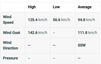
Jun 9
Some decent winds recorded in Palliser Bay
🌬️ Wind speed:
High 125.4 km/h
Average 94.8 km/h
⚠️ Gusts:
High 142.6 km/h
Average 111.8 km/h


3
30

MetIntel NZ retweeted

A state of emergency has been declared for Wellington’s Southern and Eastern Wards to support the response to the heavy swell warning for Wellington’s South Coast. For local updates go to wremo.nz/
2
14
29
5,039
Jun 8
🌊 Heavy Swell Warnings — Wellington & Wairarapa
🟠 Wairarapa: Turakirae Head to Mataikona🕛 Midnight Mon 8 Jun – 9am Wed 10 Jun🌊 Combined waves rising to 9.5–10.5m late Tue morning⚠️ Biggest impacts likely Turakirae Head to Te Kakau Point
🟠 Wellington: Cape Terawhiti to Turakirae Head🕒 3am Tue 9 Jun – 9am Wed 10 Jun🌊 Combined waves rising to 8–9m Tue afternoon⚠️ Possible refracted swell into Wellington Harbour, affecting Ngauranga to Eastbourne with 2–3m swell
🕰️ Highest risk is around high tide:• Cape Palliser: 11:29am Tue, 11:52pm Tue• Castlepoint: 11:43am Tue, 12:09am Wed• Cape Terawhiti: 12:26pm Tue, 12:49am Wed• Wellington: 11:19am Tue, 11:42pm Tue
Avoid exposed coasts, beaches, rocks and low-lying coastal roads. Conditions may be dangerous even if the weather looks calm.
Issued 11:41am Mon 8 JunNext update 2pm Tue 9 Jun
Source: MetService
metservice.com/warnings
1
148
MetIntel NZ retweeted

Jun 8
Hazardous swells set to impact eastern New Zealand early this week.
A powerful southerly swell is expected to affect eastern coastlines from Otago to Gisborne through to midweek, bringing large waves and dangerous coastal conditions.
These long-period swells carry significant energy, allowing waves to surge further up beaches, over coastal roads, and into low-lying coastal areas than usual.
Potential impacts include:
⚠️ Dangerous conditions near the coast
⚠️ Coastal inundation and wave overtopping
⚠️ Ferry disruptions and transport delays
⚠️ Local Road closures in vulnerable areas
If you're heading to the coast, stay well back from the water's edge and keep up to date with advice from local authorities and the latest Heavy Swell Warnings at metservice.com/warnings.
1
11
29
4,359
Jun 8
🟡💨 Strong Wind Watch — Coastal Wairarapa & Tararua District
🕘 Valid: Tue 9 Jun, 7:00am–2:00pm
Southwest winds may approach severe gale in exposed places.
Upgrade risk: Moderate chance of becoming a Warning.
Monitor updates:
metservice.com/warnings
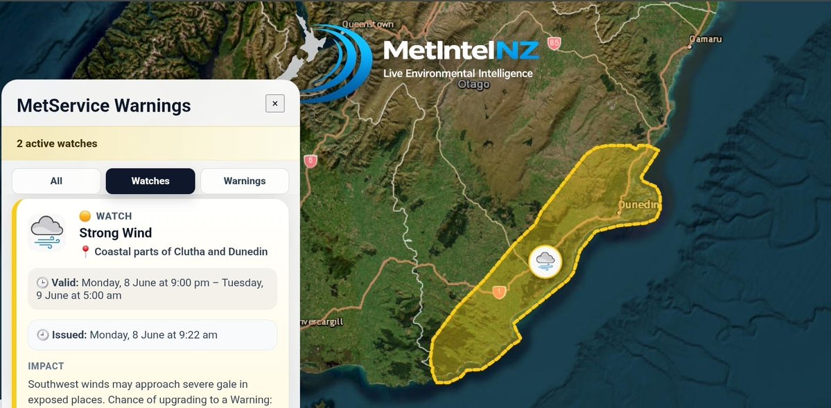
🟡💨 Strong Wind Watch — Coastal Clutha & Dunedin
🕘 Valid: Mon 8 Jun, 9:00pm–Tue 9 Jun, 5:00am
Southwest winds may approach severe gale in exposed places.
Upgrade risk: Moderate chance of becoming a Warning.
Monitor updates:
metservice.com/warnings
1
23
MetIntel NZ retweeted
We are assessing whether the M8.2 Philippines earthquake has created a tsunami that could affect New Zealand. Go to civildefence.govt.nz for more information.
2
18
31
6,214
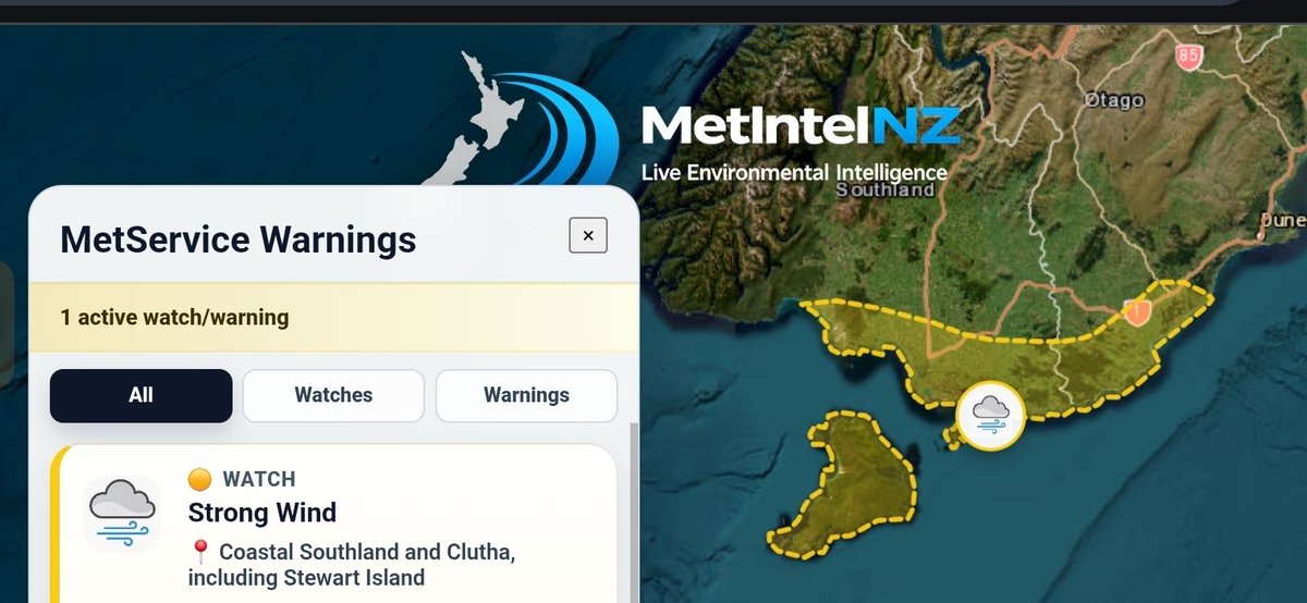
Jun 6
🟡 💨 Strong Wind Watch — Coastal Southland & Clutha, including Stewart Island
🕙 Valid: 10:00pm Sun 7 Jun – 5:00am Mon 8 Jun
Westerly winds may approach severe gale in exposed places.
Chance of upgrade to Warning: Moderate
Monitor updates: metservice.com/warnings
3
33
Jun 5
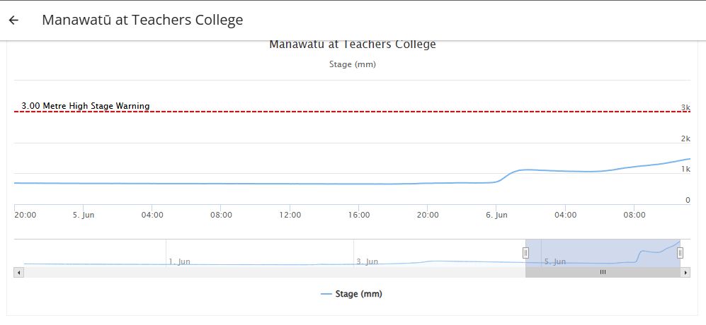
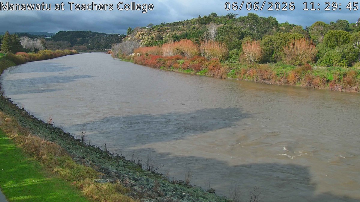
Heavy rain persists over parts of the Tararua ranges north of Lake Wairarapa to just south of Palmerston North mostly affecting catchments of the Ruamahanga and Manawatu rivers.
Only a moderate rise at Teachers College at Palmerston North but people around the river should be wary of rising levels pushing through from the Tararua side of the catchment, even if it has been barely raining on the PN side.

1
34
Jun 5
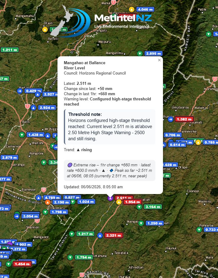
Mangahao at Ballance
River Level
Council: Horizons Regional Council
Latest: 2.511 m
Change since last: 50 mm
Change in last 1hr: 660 mm
Warning level: Configured high-stage threshold reached
Threshold note:
Horizons configured high-stage threshold reached: Current level 2.511 m is at/above 2.50 Metre High Stage Warning - 2500 and still rising.
Trend: ▲ rising
🟣 Extreme rise – 1hr change 660 mm · latest rate 600.0 mm/h · ▲ · 🔹 Peak so far ~2.511 m at 06/06, 08:05 (currently 2.511 m, near peak)
Updated: 06/06/2026, 8:05:00 am
1
33
Jun 5
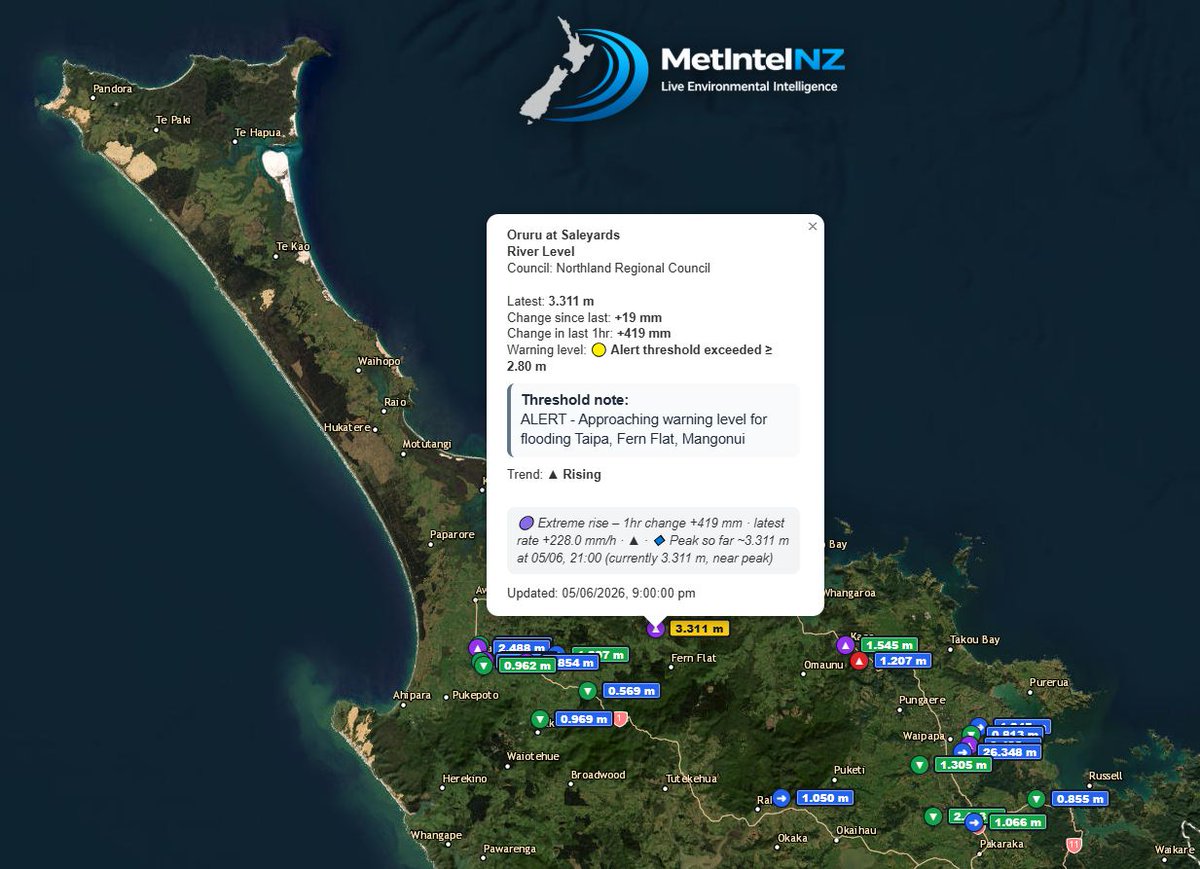
Oruru at Saleyards
River Level
Council: Northland Regional Council
Latest: 3.311 m
Change since last: 19 mm
Change in last 1hr: 419 mm
Warning level: 🟡 Alert threshold exceeded ≥ 2.80 m
Threshold note:
ALERT - Approaching warning level for flooding Taipa, Fern Flat, Mangonui
Trend: ▲ Rising
🟣 Extreme rise – 1hr change 419 mm · latest rate 228.0 mm/h · ▲ · 🔹 Peak so far ~3.311 m at 05/06, 21:00 (currently 3.311 m, near peak)
Updated: 05/06/2026, 9:00:00 pm
1
36
Jun 5
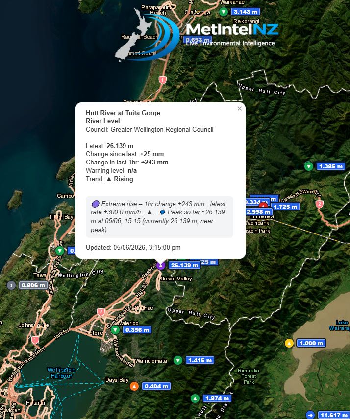
Hutt River at Taita Gorge
River Level
Council: Greater Wellington Regional Council
Latest: 26.139 m
Change since last: 25 mm
Change in last 1hr: 243 mm
Warning level: n/a
Trend: ▲ Rising
🟣 Extreme rise – 1hr change 243 mm · latest rate 300.0 mm/h · ▲ · 🔹 Peak so far ~26.139 m at 05/06, 15:15 (currently 26.139 m, near peak)
Updated: 05/06/2026, 3:15:00 pm
1
34
Jun 5
Levin
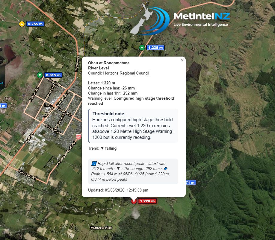
Ohau at Rongomatane
River Level
Council: Horizons Regional Council
Latest: 1.220 m
Change since last: -26 mm
Change in last 1hr: -292 mm
Warning level: Configured high-stage threshold reached
Threshold note:
Horizons configured high-stage threshold reached: Current level 1.220 m remains at/above 1.20 Metre High Stage Warning - 1200 but is currently receding.
Trend: ▼ falling
↘️ Rapid fall after recent peak – latest rate -312.0 mm/h · ▼ · 1hr change -292 mm · 🔹 Peak ~1.564 m at 05/06, 11:25 (now 1.220 m, 0.344 m below peak)
Updated: 05/06/2026, 12:45:00 pm
2
29
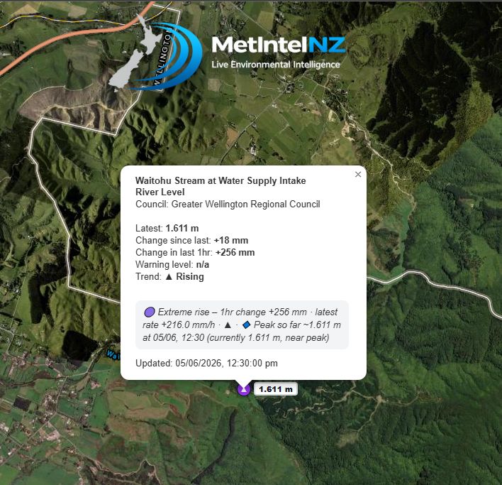
Jun 5
Otaki
Waitohu Stream at Water Supply Intake
River Level
Council: Greater Wellington Regional Council
Latest: 1.611 m
Change since last: 18 mm
Change in last 1hr: 256 mm
Warning level: n/a
Trend: ▲ Rising
🟣 Extreme rise – 1hr change 256 mm · latest rate 216.0 mm/h · ▲ · 🔹 Peak so far ~1.611 m at 05/06, 12:30 (currently 1.611 m, near peak)
Updated: 05/06/2026, 12:30:00 pm
2
20
Jun 5
South of Levin
Ohau at Haines Ford
River Level
Council: Horizons Regional Council
Latest: 4.215 m
Change since last: 20 mm
Change in last 1hr: 1402 mm
Warning level: n/a
Trend: ▲ rising
🟣 Extreme rise – 1hr change 1402 mm · latest rate 240.0 mm/h · ▲ · 🔹 Peak so far ~4.215 m at 05/06, 12:15 (currently 4.215 m, near peak)
Updated: 05/06/2026, 12:15:00 pm
1
2
35
Jun 5
NZ: Thunderstorms & downpours as cold front moves through youtu.be/RytXHMGshHM?si=zW0o… via @YouTube
1
26
Jun 4
🌧️🟡 Heavy Rain Watches
⏰ Today Fri 5 Jun into Sat 6 Jun
Bay of Plenty from Whakatāne westwards & Taupō
Valid: 3pm Fri–midnight
Periods of heavy rain may approach warning criteria. Squally thunderstorms and localised downpours possible this evening.
Waitomo, Taumarunui & Tongariro National Park, including the headwaters of the Whanganui River
Valid: 1pm–11pm Fri
Heavy rain may approach warning criteria. Squally thunderstorms possible.
⏰ Onset delayed until this afternoon.
Horowhenua, Kāpiti Coast & Wellington
Valid: 9am Fri–2am Sat
Periods of heavy rain with possible thunderstorms. Amounts may approach warning criteria.
⚠️ Tararua Range upgraded to Orange Warning.
Buller & the Tasman Ranges
Valid: 9am Fri–midnight
Periods of heavy rain and possible thunderstorms. Amounts may approach warning criteria.
Marlborough north of the Wairau River
Valid: 9am–9pm Fri
Periods of heavy rain, with thunderstorms possible. Rainfall may approach warning criteria.
💨🟡 Strong Wind Watch
Taranaki, inland Whanganui & Taihape
Valid: 11am–6pm Fri
Northerly winds may approach severe gale in exposed places.
Chance of upgrade to Warning: Moderate for all listed watches.
Monitor for updates.
Official info: metservice.com/warnings
2
26
Jun 4
🌧️🟠 Heavy Rain Warning — Orange
⏰ Today Fri 5 Jun into Sat 6 Jun
Bay of Plenty east of Whakatāne
Valid: 5pm Fri–3am Sat
Expect 70–90mm of rain. Peak rates 15–25mm/h from evening, possibly 25–40mm/h in localised downpours. Squally thunderstorms possible.
Tararua Range
Valid: 9am Fri–3am Sat
Expect 100–130mm of rain. Peak rates 15–25mm/h, especially in thunderstorms.
⚠️ Watch upgraded to Orange Warning.
Taranaki north of Eltham
Valid: 9am–9pm Fri
On top of what has already fallen, expect 70–90mm, but 120–150mm about Taranaki Maunga. Peak rates 15–25mm/h, possibly 25–40mm/h in localised downpours this afternoon/evening. Heavy showers likely after the warning period.
Main risks:
🌊 Streams and rivers may rise rapidly
🚗 Surface flooding, slips & difficult driving possible
⛈️ Thunderstorms/downpours possible
🔴 Chance of upgrade to Red: Minimal
Clear drains/gutters, avoid low-lying areas, and drive cautiously.
Official info: metservice.com/warnings
2
37