
Magician LoganMagic.com
Joined December 2009
- Tweets 10,333
- Following 7,502
- Followers 1,344
- Likes 47,146
1,755 Photos and videos


This sounds fishy:
“The Admin asked Dario to fix the jailbreak or de-deploy the model. Dario refused.”

I’ve had a number of conversations with folks inside and outside government about the current situation with Anthropic, and here is what I believe to be true:
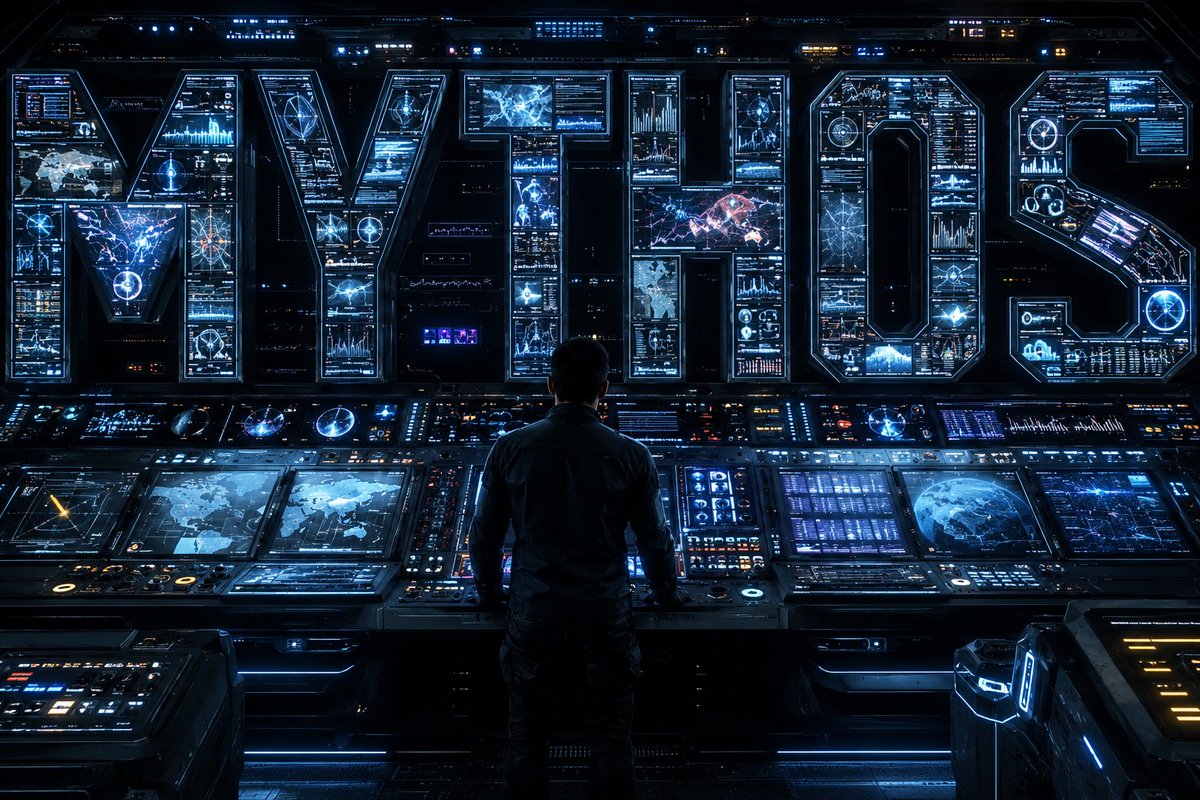
— As we know, Anthropic publicly released its Mythos class models earlier this week under the commercial name Fable.
— Fable is Mythos with guardrails. But if those guardrails fail, then you’ve exposed Mythos and its advanced cyber capabilities to people who shouldn’t have them. (Keep in mind that Anthropic itself widely promoted the idea that Mythos was a cyberweapon and needed to be regulated as such. They asked for government regulation of Mythos and championed the guardrails on Fable. If there is a vulnerability — big or small — it is Anthropic’s responsibility to patch.)
— A highly credible trusted partner of both Anthropic and the USG who was testing Fable came forward with a jailbreak of those guardrails. The Admin asked Dario to fix the jailbreak or de-deploy the model. Dario refused.
— In their blog post, Anthropic defended its decision by saying the jailbreak isn’t serious. That is not what the trusted partner and the USG believe; nor is that kind of minimizing language consistent with Anthropic’s brand as the AI safety company. It’s difficult to fathom how they could claim a jailbreak allowing operability of a cyber weapon could be defined as not “serious.”
— In the past, Anthropic has always said that safety must be top priority and taken super seriously. In this case, Anthropic prioritized the continued offering of the consumer model over safety.
— In reaction, the Admin issued the export control. The Admin did this reluctantly. It’s been very surprised that Anthropic hasn’t wanted to cooperate with a reasonable safety request (ie fixing the jailbreak issue). Anthropic’s reaction is very much at odds with their branding and ethos as a safe AI research community.
— The Admin’s hope now is that Anthropic remediates the safety issue, the export control is lifted, and Fable goes back into general release. The Admin wants all of this to happen as soon as possible. It is frankly bewildered that Anthropic hasn’t wanted to comply with safety requests that it previously said were its highest priority.
— Those trying to misdirect and tie this action to the prior DoW/Anthropic issues are wrong. The Admin values Anthropic’s technical capabilities and feels that this issue, while serious, should be easily resolved. The ball is in Anthropic’s court.
1
25
Joshua Logan retweeted

Jun 11
We are entering the age of just-in-time software. Some of my coworkers are visiting San Francisco this week, so I asked Claude Fable to design an extremely detailed HTML map of San Francisco so I can explain the city to them.
The HTML is wild. It has all the street names, their exact dimensions, the relief of the city, the fog, the sun exposure etc.
Everything it real. I was super surprised but it went and found the city's actual data, then built a cartographic engine around it. So I have:
- Every street from the SF Public Works centerline survey: 15,905 segments, 2,502 named streets, 54,989 surveyed vertices, with the official address ranges per block
- The relief from 14,151 municipal elevation contour points, interpolated into a 168,000-vertex terrain model
- 9,672 buildings with lidar-measured heights from an SF Planning study
- Every Muni Metro line, the cable cars and BART from the official GTFS feed: real route shapes, real 10-minute headways, real speeds. 76 little trams move on the map at their scheduled pace, and the K dims when it passes under 175 meters of Twin Peaks because it knows the tunnel portals (wtf!)
- Fog modeled as marine-layer advection over the terrain, calibrated on NREL satellite irradiance and a decade of ASOS weather observations.
Claude did totally overkilled stuff like the fog model's 50% line landed at longitude -122.437 which is... Divisadero Street (every San Franciscan knows the fog stops there)
The whole thing is one self-contained HTML file, 1.2 MB, with a WebGL engine. No libraries, no API calls, no network. It runs offline forever.
We talk about scaling and benchmarks all day. Sometimes the bitter lesson is simpler: give the machine real data and real verification loops, and it builds you the city.
I'm spending the evening exploring the map; it's too good!
61
60
1,152
155,239
Joshua Logan retweeted

Jun 11
The only limit should be your imagination! Hybrid filmmaking is the future.
60
46
372
59,765
Joshua Logan retweeted

Jun 10
With these updates I think Bugbot might be the best code review tool on the market. Highly customizable, fully integrated, highest recall/price/speed ratio available out there.
This is so exciting for helping solve the agentic coding bottleneck
Loved working on this with @TomasReimers @yuri__volkov @jwswj @michaelz331
Jun 10

Cursor’s code review agent is now over 3x faster, 22% cheaper, and finds 10% more bugs.
You can also use /review to run Bugbot locally to catch and fix issues before pushing code.
11
6
106
7,255
Joshua Logan retweeted

Jun 9
claude opus 4.8 OpenClaw now finds restaurants with weak food photos, rebuilds their best dish into a cinematic reel, and mails the owner a postcard with the QR...on autopilot.
here's how agencies can land recurring contracts with this system:
- scans every restaurant in a city in real time
- pulls their real reviews, ratings, and reviewer-uploaded food photos
flags the weakest shot of their signature dish
- samples the brand color straight from the restaurant's own dish photo
rebuilds that exact plate into a cinematic 9:16 reel
- writes a printed postcard about their best dish
- mails it to the registered office, addressed to the owner, with a QR to the live reel
every step from the scrape to the reel to the mailbox is automated
reply "REEL" RT and i'll send you a free guide so you can build this too (must be following so i can DM you)
1,036
598
2,376
187,749

Jun 9
Monitoring

16
Joshua Logan retweeted

Jun 7
a reminder that branding matters.


358
1,063
22,434
4,067,449
Joshua Logan retweeted

Jun 4
👀WHAT SECRET AI VIDEO MODEL IS THIS?
IS IT HAILUO 3?
IS IT SEEDANCE 2.1?
IS IT KLING?
What do you think?
Goes by the name of PURPLE and just landed on
Artificial Analysis. It's GOOD! Spent about an hour pulling some additional samples and will post some more samples in thread below.
A vintage car's curved chrome bumper reflecting a distorted fisheye view of a 1950s gas station. As someone polishes the bumper with a cloth, the reflection clarifies temporarily before fingerprints and cloth streaks create new distortions. The pump attendant's reflection stretches and compresses as he moves around the vehicle. Audio: Cloth buffing chrome, distant traffic, vintage radio music. 🔽
59
31
392
76,974


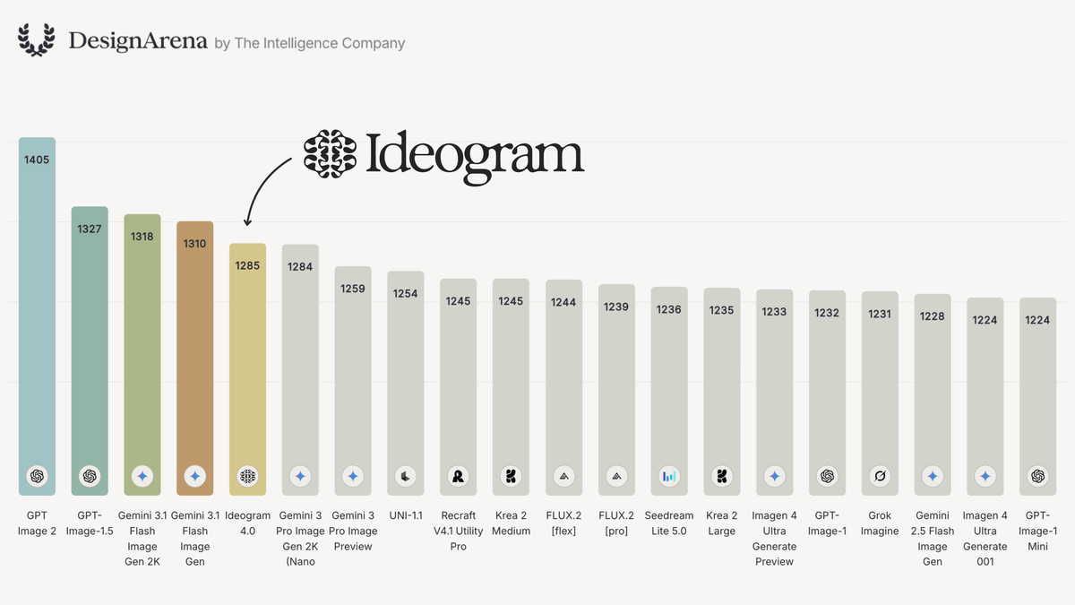
Ideogram 4.0 is incredible.
And it's open. Download the weights below.


Jun 3

Introducing Ideogram 4.0: the best open image model in the world.
Think it. Make it. Own it.
Download the weights, fine-tune on your own data, and run it on your hardware. Live on every Ideogram plan and the API today.
33
75
1,593
226,848
Jun 3
I was AI storyboarding at 10 zebra before Scorsese made it cool 😜
Jun 3

me watching keyboard warriors pretending they were tech bros and pro-AI all along

1
3
1,307
Joshua Logan retweeted

Jun 3
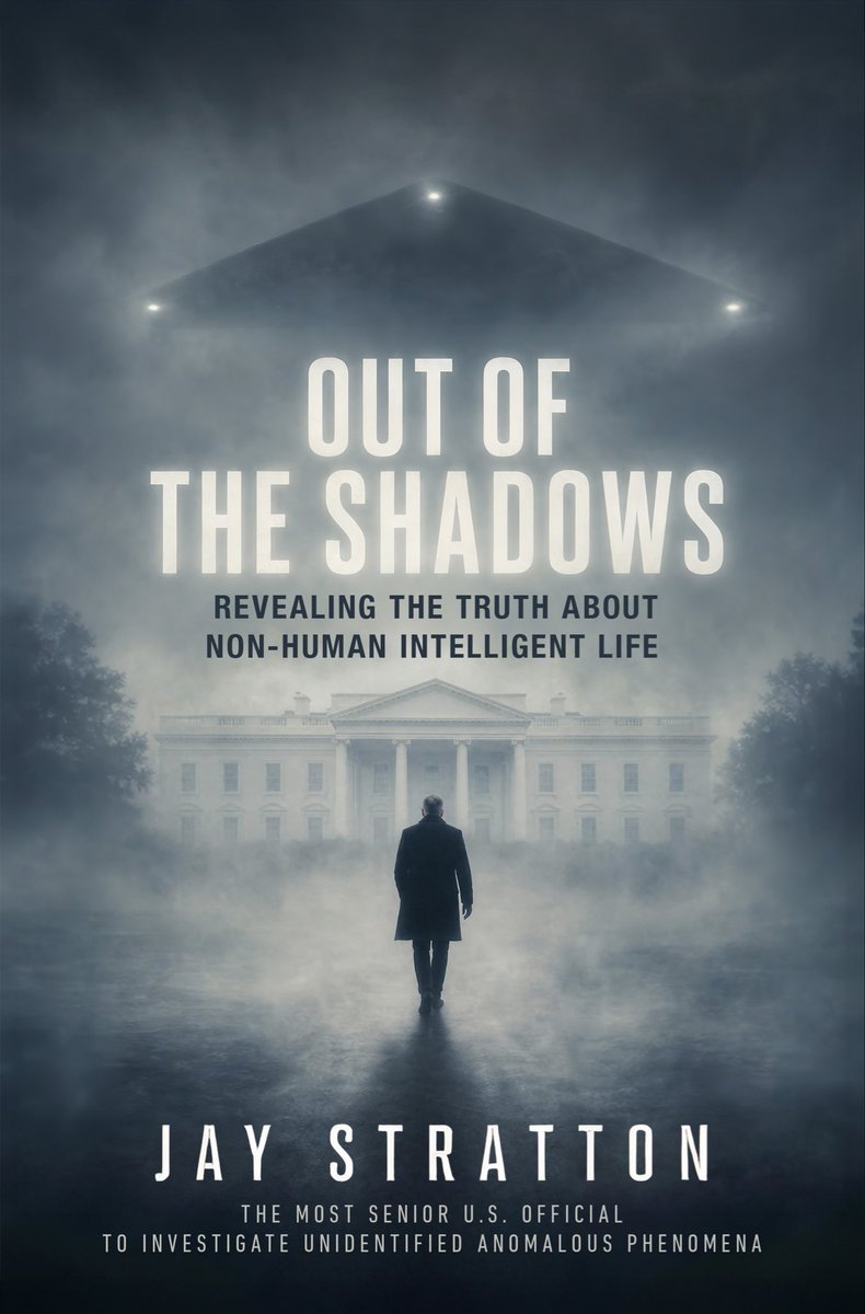
I’m excited to announce my memoir, Out of the Shadows, will be published by HarperCollins in North America on October 13, 2026. In the book, I break my silence to reveal everything I legally can about my investigations of UAP and non-human intelligent life on behalf of the U.S Government and the profound impact my work had on me and my family. We are at a turning point in human history and I am proud to play a role in opening the public’s eyes to the truth and bringing about long overdue disclosure.
544
989
5,782
524,938
Joshua Logan retweeted

Jun 2
Storyboards by an 11 year old Martin Scorsese.
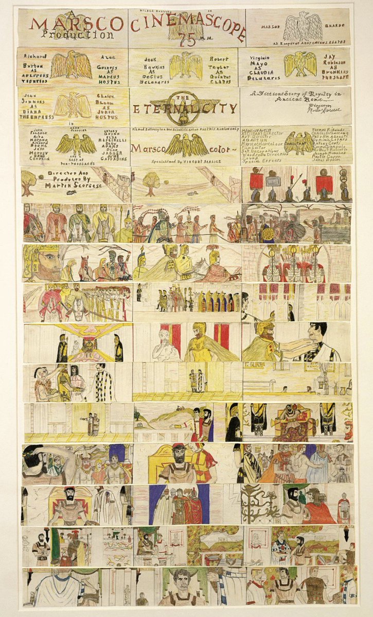

Martin Scorsese has joined a generative AI startup as a partner and advisor.
He adds that he has used AI during pre-production to help with storyboarding — “with this tool, I can share what I’m visualizing more clearly & efficiently to my creative team — the production designer, art designer and cinematographer.”
(Source: nytimes.com/2026/06/02/busin…)


7
145
1,220
38,439
Joshua Logan retweeted

Jun 2
A milestone I've been quietly waiting to share: Martin Scorsese has joined @bfl_ai as an advisor.
We filmed a storyboarding session with him using FLUX and watching him use it not to replace his eye, but to get what's in his head in front of his crew faster. He called it creatively freeing. His words for it: cinematic intelligence.
Proud of everyone at BFL who made it real and of what we are building
Jun 2

Martin Scorsese is an advisor to Black Forest Labs.
He's spent six decades shaping how the world sees stories. Now he's helping us shape visual intelligence with human taste and craft at the center.
We sat down with him for a working storyboarding session using FLUX.
40
10
181
20,631

Martin Scorsese Backs AI Company and Says He's Using It to Storyboard Movies: 'We Have to Be Open to How' Cinema Can 'Evolve' variety.com/2026/film/news/m…
93
47
232
76,890

The next version of NoSpoon is going to be wild, interactive, fun, and absolutely jam packed with new features.
The design is meant to be more creative and less 'sterile'.
Some of you will love it, some of you may hate it.
But overall, it's taking a step into a highly interactive direction that I think despite driving me crazy overall will be hugely valuable
3
1
26
627
Joshua Logan retweeted

May 31
GPT Realtime 2 unlocks some real magic:
May 30

Watch me control my computer with just my voice. This is the future of operating systems.
No hands.
GPT-Realtime 2.0 is very, very underrated.
Demo:
132
124
2,758
362,742
Joshua Logan retweeted

May 30
SOME GUY BUILT A 24/7 ONLINE RAVE IN YOUR BROWSER AND IT IS COMPLETELY FREE TO ATTEND
it's called Hallucinate.
you click one link, your browser loads a 3D field at night, and suddenly you are standing in a crowd of hundreds of low-poly strangers dancing under a moon to a youtube video playing on a giant screen.
there is no login. there is no wallet. there is no signup. you are just at the rave.
the rave has its own keyboard.
> 7 and 8 cycle your hair color
> 9 and 0 cycle your skin tone
> U and I cycle your hair style
> L and ; cycle your dance moves
> V is the wave emote
> B is the bounce emote
> SPACE bar is literally labeled "speak"
every other person in the room is a real human pressing the same keys, in real time. nobody ever stops dancing because the creator wrote on hacker news: "everybody dancing forever is crucial for the feeling. you don't stop dancing in a rave."
the dev who made it goes by the handle stagas. he says the entire thing was "vibe coded in its entirety" by an LLM. the commit messages on the repo are three words long: "cool." "jump jump." "perf." he has about 500 other repos on his github account.
the post went up on Show HN two days ago. it is currently sitting at 435 points and 193 comments and the top discussion in the thread is people arguing whether magic numbers in shaders.ts disqualify you from getting a job.
we built the global internet so that two strangers across the planet could fall in love or trade stocks or topple regimes. and the very best thing happening on it right now is a thousand cubes dancing forever under a fake moon.
the internet is healing.
109
217
1,746
247,118
Joshua Logan retweeted

May 27
This indie team is making a puzzle platformer where you play as the severed hand of a victorian magician searching for his body
- Use speed, stealth & cunning to navigate
- Develop new abilities
- Bttle bosses
Would you play this? It's Called The Magician's Hand.
42
184
1,474
78,347