
Data Viz, Maps & GIS. Tech Writer for MapTiler. FOSS4G UK 2019 Co-Chair. Honorary Fellow of the University of Edinburgh GeoSciences. Views are all mine.
Joined September 2011
- Tweets 23,719
- Following 803
- Followers 2,954
- Likes 51,074
983 Photos and videos


Pinned Tweet

4 May 2021
I did a comparison of the different hill shading tools in #QGIS and got some amazing results. Each one was blended with a DTM to give a bit of depth. Have a look at this thread for details on the 7 ways I tried, these are the most interesting. 1/n

6
51
204

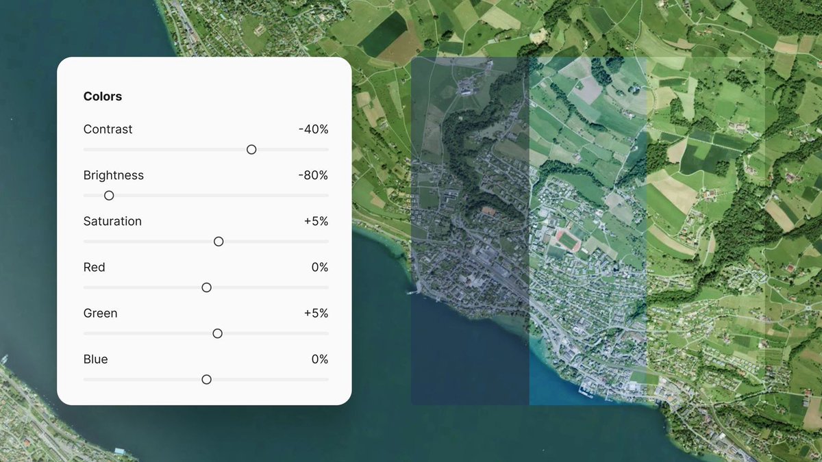
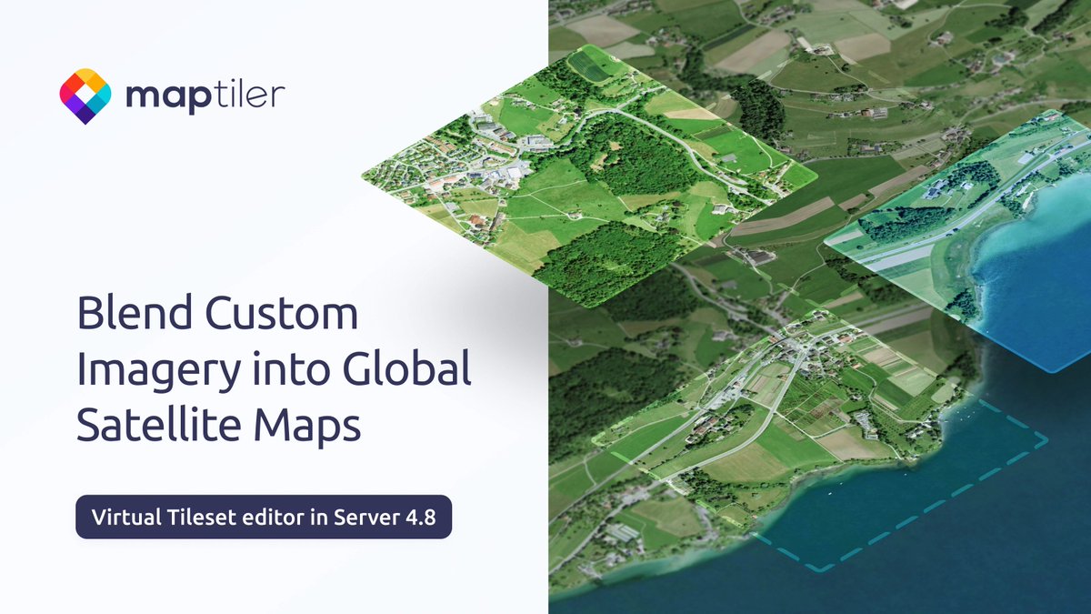
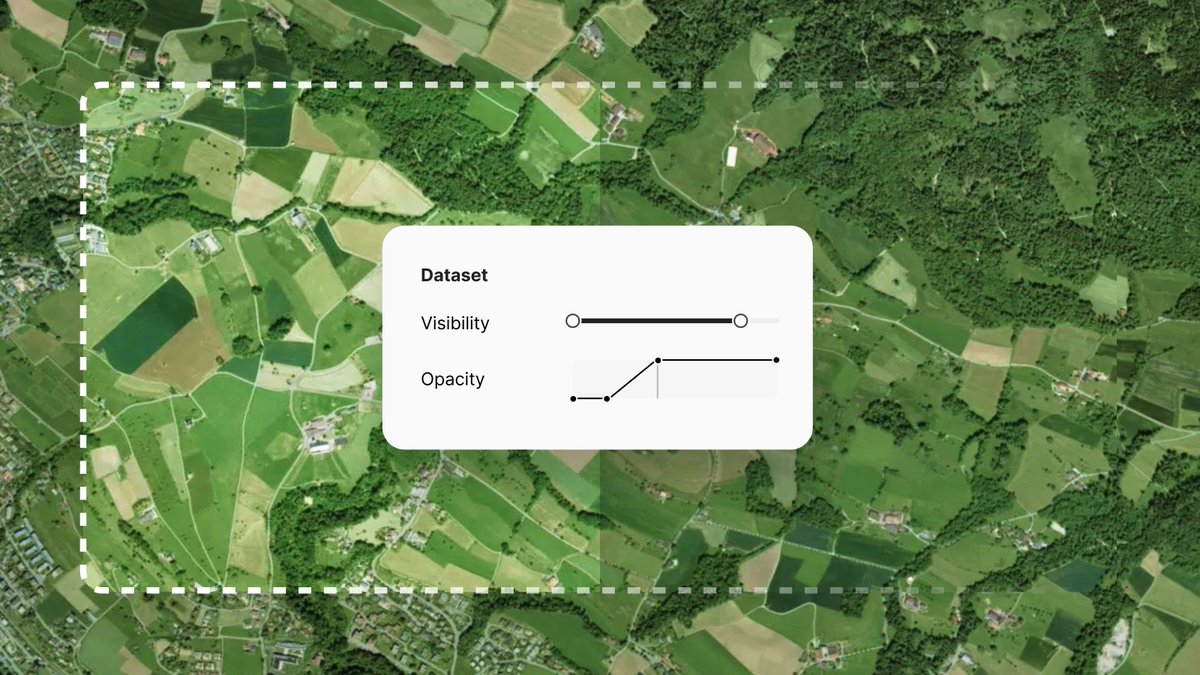
Blend your imagery into global satellite maps on-prem. Match the brightness, contrast, and saturation of your imagery to the existing base map. You can also fine-tune the color by adjusting the Red, Green, and Blue levels. Read more: maptiler.link/4dQjQd7
2
3
261
Tom Armitage retweeted

Jun 3
Maptiler GeoSplats = Photorealistic 3D visualizations on a map maptiler.com/geosplats/
14
84
3,743
Visualize users' journeys with #3D models of their mode of transport, tracing their routes. Show a car traveling along roads or animate a plane flight from one city to another. Find out more: maptiler.link/4wduW34
2
5
720
Tom Armitage retweeted

May 28
🌋 A newly discovered underwater volcano in the Bismarck Sea off Papua New Guinea 🇵🇬 is erupting.
🛰️ Captured by #CopernicusEU Sentinel-2, the image reveals ash, discoloured waters and volcanic plumes linked to the ongoing eruption.
🔗 link.europa.eu/jbV9b3
#ImageOfTheDay

3
32
138
10,131
Tom Armitage retweeted

May 27
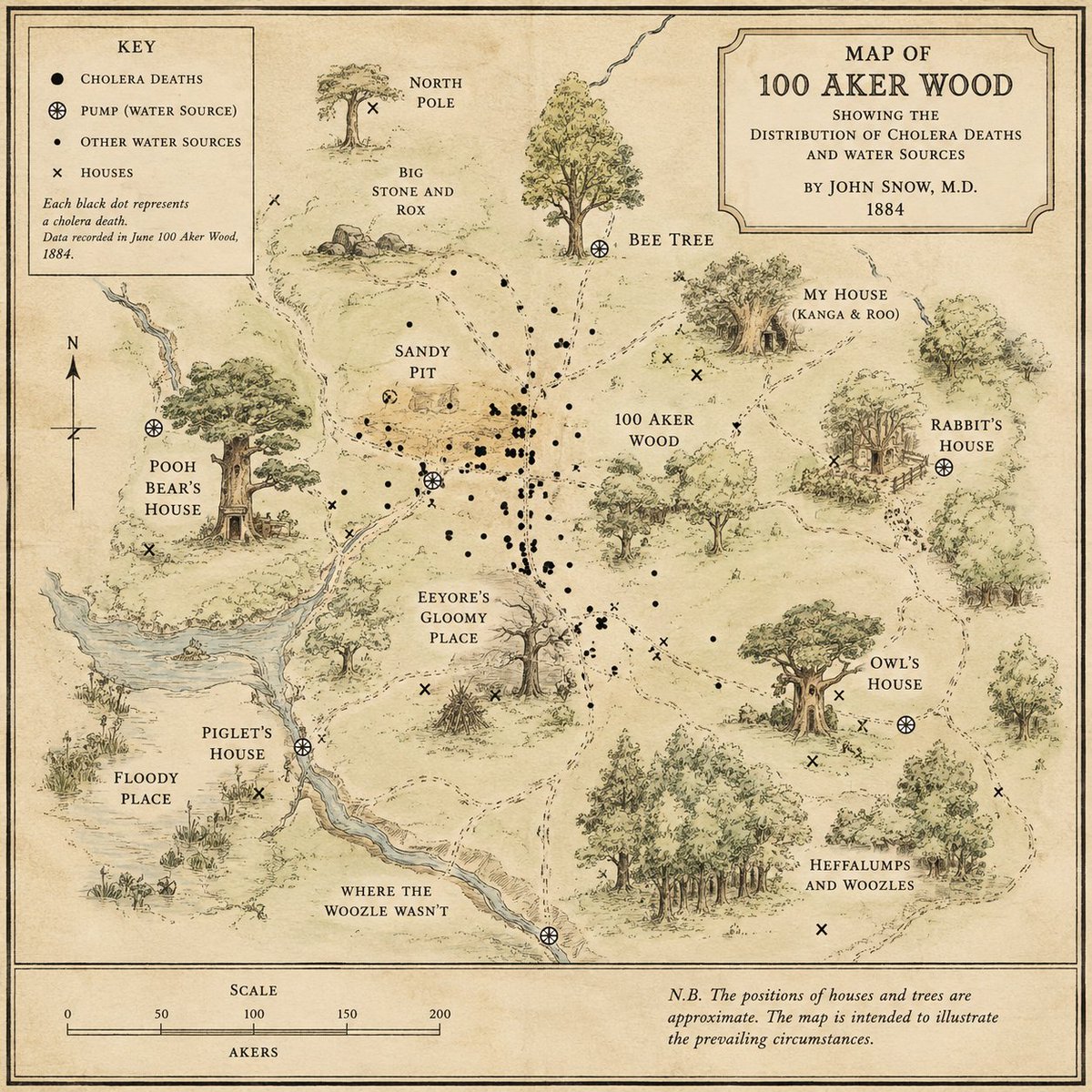
Apropos of nothing I asked AI to create a map of 100 Aker Wood as if that community had suffered a significant outbreak of cholera. The result is bordering on brilliant, and clearly establishes the cause of the outbreak as Pooh in the water source near Piglet's house.
3
4
18
1,819
Tom Armitage retweeted

May 27
Extending my #QGIS color sampling tools series, I’m currently developing a tool that converts RGB values sampled from scanned maps into a #GPL file, allowing them to be easily imported as a color palette directly into the #Colors panel. I’ll make it available online soon!
May 24

Developing a color wheel in #QGIS to plot colors I sampled from a scanned historical map. Plotting all of them by Hue and Saturation instantly reveals patterns, color harmonies, and contrasts. A deep dive into understanding how and why color palettes work in old maps.
1
12
67
4,723
Tom Armitage retweeted

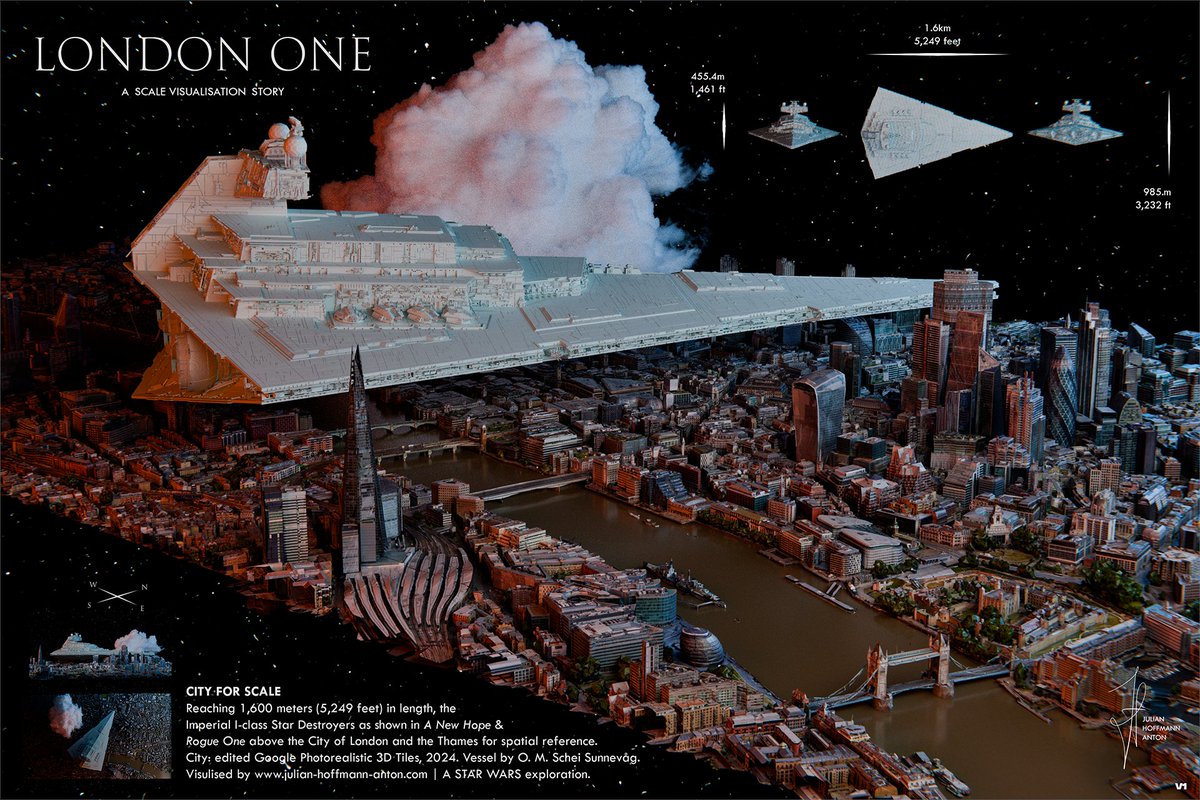
Who needs a scale bar when you can use a city?
I put an Imperial I-class Star Destroyer (1,600m) from Rogue One and A New Hope over the City of London. Made in Blender.
1
4
31
3,255
Tom Armitage retweeted

May 19
146 million US jobs.
Visualized by sector on a fast, filterable interactive map.
Fly from market to market smoothly with @MapTiler's geocoder.
Explore for yourselves: walker-data.com/freestiler/l…
3
13
90
10,008
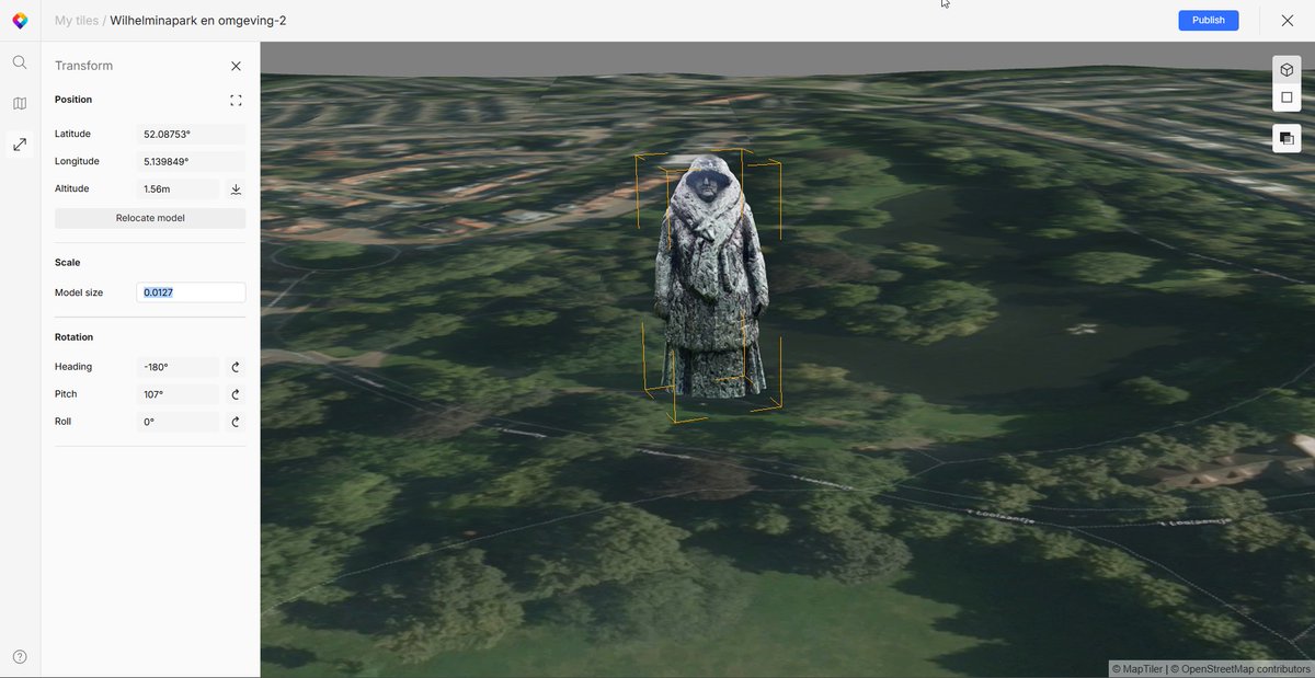
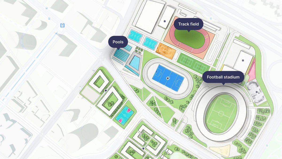
Create interactive buildings for #3D real-estate visualizations. Place, highlight, and interact with detailed models, floor by floor, building by building. Find out more about this and the rest of the latest news from MapTiler here: maptiler.link/49F9uKy
2
6
23
1,324
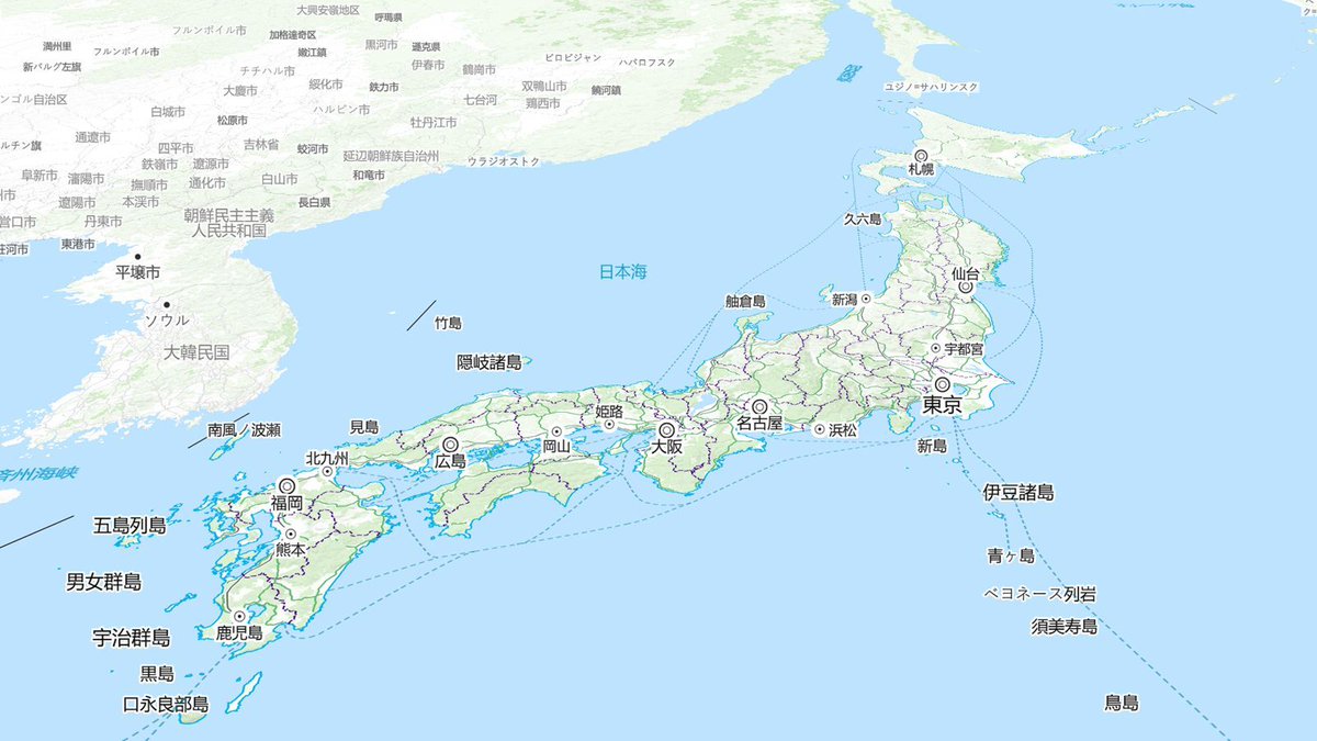
Our lead cartographer @cartogenic drew on his experience living in Osaka to create the perfect map for #Japan. It uses both the official @gsi_cyberjapan data & our own Planet v4 dataset, giving familiar features in a clean, modern map style. Find out more: maptiler.link/4v1q2oE
2
17
1,046
Serve your imagery blended into global satellite maps. Check out our new virtual tileset editor in MapTiler Server 4.8! Find out the details and watch the launch webinar here: maptiler.link/4dhfXOj
#AerialImagery #Satellite #OnPrem #Maps

4
18
1,332
Our new #map for #Japan is designed with symbols, naming conventions, and feature semantics that the locals are familiar with. It’s just one of the latest updates from MapTiler, which you can read about on our blog: maptiler.link/49F9uKy

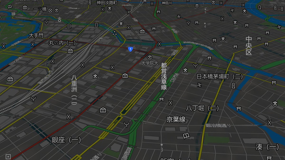
1
3
38
3,181
Tom Armitage retweeted

May 13
New blog post! GISRUK 2026: GIS that makes a difference
I was fortunate to be able to attend GISRUK 2026, at Uni of Birmingham. It’s great to see the latest GIS Research, catch-up with old colleagues &make new connections.
Check out the whole blog at nickbearman.com/blog/2026-05…
2
9
483
MapTiler Server 4.8 released! Don’t forget tomorrow’s webinar about what's new in the latest version. Find out how you can blend your imagery into global datasets and more. It’s your last chance to register here: maptiler.link/496wQsD

2
34
2,114
Our new Georeferencer eliminates the technical friction of manual file conversion for five major formats: PNG, JPEG, PDF, TIFF, and WebP. It allows you to define the location of your geodata effortlessly.
Find out more: maptiler.link/41v8MLM
#MapTiler #Geodata #WebMapping
9
64
3,700
Check out the latest news from MapTiler: Interact with #3D Models on your maps, and a new Japanese map style! Read more: maptiler.link/4np4ob5

2
16
906
Tom Armitage retweeted

May 6
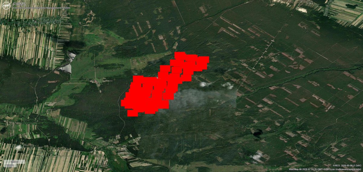
Przygotowałem mapy z zasięgiem pożaru w Nadleśnictwo Józefów
Szacunkowa powierzchnia wg. stanu na 06.05.2026 godz. 7:00 wynosi 480 ha.
Opracowanie bazuje na danych pozyskanych z systemu NASA FIRMS.
firms.modaps.eosdis.nasa.gov…


4
31
131
23,672
Tom Armitage retweeted

Fifteen Maps that Changed How We See the Ocean Floor:
libraryoflostmaps.com/2026/0…
2
3
393
Tom Armitage retweeted

Investigating Polish and Italian Experience in Scotland. Can you help Benjamin Harris, a PhD historian from the University of Strathclyde, with his research? Here is a link to his survey request buff.ly/MOeovfn #polish #Italian #livinginscotland

2
3
314