
Atmospheric scientist, storm chaser, adventurer, teacher, author. Senior meteorologist at @MyRadarWX. Usually found frolicking in giant hail. Harvard/MIT 🌪
Joined June 2014
- Tweets 75,484
- Following 402
- Followers 126,107
- Likes 262,928
25,716 Photos and videos


Pinned Tweet

18 Nov 2019
My mother always said you can smile in any language.

108
273
3,547
StormNet is the most skillful model (AI or NWP) when it comes to early identification of severe weather setups.
Wednesday looks concerning in the Midwest. Only 5 or 6 times a year do we see the model this aggressive this far in advance.
12h

Elevated threat of tornadoes detected for Wednesday, June 17th, 2026.
See attached map for details.
This forecast initialized on Saturday morning. Follow for future forecast updates.

ALT StormNet-v4 tornado probability map with a 69% maximum 12-hour risk from 2026-06-17 18Z to 2026-06-18 06Z. Model initialized 2026-06-13 12Z at forecast hour 114.
9
16
223
19,959
Matthew Cappucci retweeted
Amazing, eerie blues with this powerful supercell north of Blue Rapids, Kansas.
Tornado threat is tempered right now by what appears to be outflow dominance — the storm looks like it’s exhaling more cool air than it’s ingesting warm air.
4
20
166
8,228
Sirens are blaring in Blue Rapids, Kansas as a blue storm rapidly enters town:
6
25
229
17,127
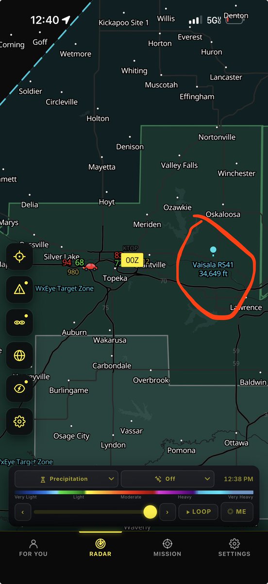
Tracking a tornado-warned supercell north of Blue Rapids, Kansas.
Roadways remain free of sticks, leaves and controversy at present.
7
11
127
6,393
Matthew Cappucci retweeted
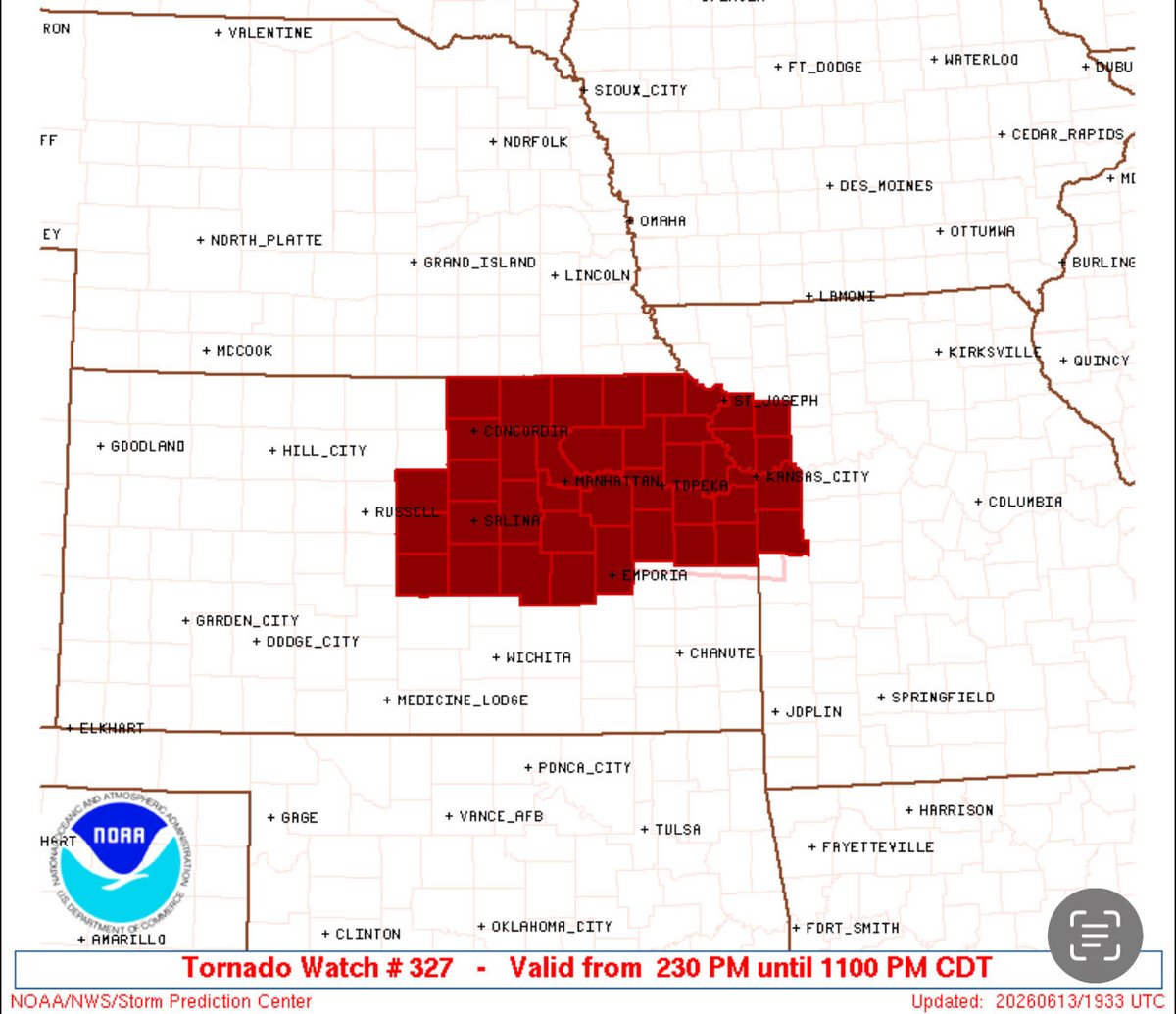
A tornado watch has been issued for the I-70 corridor of central and eastern Kansas and northwestern Missouri until 11 p.m.
This included the Kansas City metro.
1
7
37
4,023
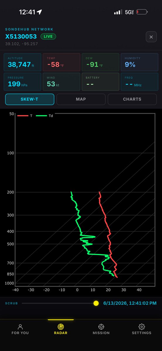
In an era when sparse 12Z weather balloon launches are lacking and degrading modeling and forecasts, Vince’s work is incredibly valuable in helping fill some gaps.
Loving what I’m seeing from Project WeatherEye:

9
13
212
15,697
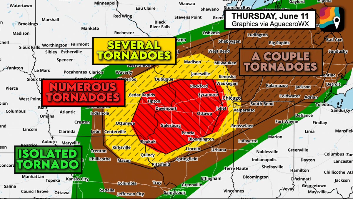
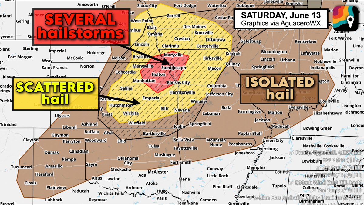
Scattered severe storms, including some supercells, are likely today.
Initial rotating storms form along an outflow boundary near the Kansas-Nebraska border. Hail and tornado risk.
Then they merge into windy lines.
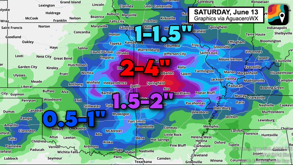
Separate flood risk in southwest MO:
3
4
55
4,339
Minor nitpick: the survey team confirmed EF1 damage. Not an EF1 tornado.
Reminder for the public: the Enhanced Fujita Scale rated damage — not tornadoes.
This was a strong tornado that happened to not hit much. Its winds were upper-echelon.
Jun 12

Our survey team has confirmed an EF-1 tornado in central Livingston County, including near Dwight. The tornado appeared to be largely in open fields limiting the number of structures impacted.
More updates will be coming soon. #ILwx
8
10
217
21,570
Matthew Cappucci retweeted
We expect some initial supercells to form in this zone today with an attendant tornado and hail risk.
Tonight we'll see storms merge into one or more windy lines and clusters as they sag southeast.

7
76
6,751
Matthew Cappucci retweeted
There is a moderate risk of flash flooding and excessive rainfall in southwest Missouri tonight.
Morning storms have left behind a boundary along which additional storms will form and propagate southeast. Storms will train, or move repeatedly over the same areas. Localized 6".

3
25
4,444
Matthew Cappucci retweeted
Level 3 out of 5 Enhanced risk of severe weather today. Initial storms may produce hail/isolated tornadoes as supercells.
Then storms merge into windy lines/clusters tonight as they sag south/southeast.


1
9
47
5,216
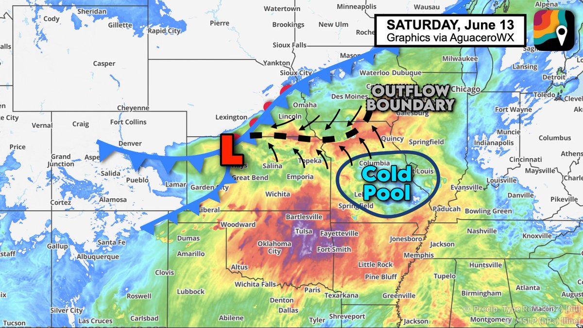
Really eyeing where this outflow boundary from the northern storm complex intersects with an approaching frontal system/low pressure.
Enhanced spin along the boundary could bolster supercell/tornado risk in northern Kansas and northwest Missouri.
6
15
197
18,676
Jun 13
Trying to make fluid dynamics simple for the layman. 🤣
13
1
99
8,192
Jun 13
I can’t believe I didn’t even get to debut the MUMBO hat this season.
15
2
174
7,019
Jun 13
“We have no idea” was a line I used a couple times when doing TV weather. It used to freak producers out.
But my goal is to exude competence — not confidence.
As Andrew shows in his tweet, the most competent thing to do sometimes is explain lack of confidence in a solution.

So you want to be a meteorologist? This storm forming off the higher terrain will have some implications for tomorrow. What those implications are is anyone's guess, as we have no idea how any MCS will evolve tonight. My guess is it'll leave a boundary somewhere in KS.
9
8
300
65,591
Jun 13
I took nap and did not awaken less cranky about yesterday.
Drat.
On the plus side, I had time to get a haircut, so no longer look like a sad pale chia pet.
Back to D.C. next week!
11
3
197
8,185
Jun 12
On the one hand, no free breakfast.
On the other hand, I have room for 249 friends.
31
14
930
27,739
Matthew Cappucci retweeted

Jun 12
A few strong storms will impact the East Coast this afternoon.
Sporadic strong gusts of 50-60 mph are possible. Small hail will accompany the strongest storms too.
@MatthewCappucci has an update.
1
2
25
3,852
Jun 12
Goodness – there were times when the base of the vortex was just 1-2 feet wide.
One of my many hypotheses for these summertime needle tornadoes: rapid latent heat release as water from grasses/damaged crops adds additional buoyancy/stretching at the lowest levels.
Jun 12

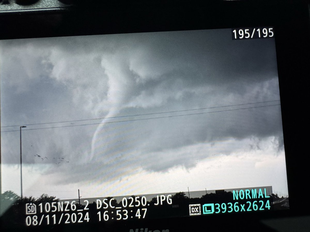
What happens next???? Watch Full video on my YouTube here which includes entire unedited video of the tornado from close range
Crazy Drone Tornado Video and Tornado Damage
youtu.be/Q7Bp1tuqurA
#tornado #ilwx
10
4
140
13,898