
Official Twitter account for the National Weather Service Tulsa, Oklahoma. Details: weather.gov/nws_x
- Tweets 45,029
- Following 254
- Followers 53,791
- Likes 6,774


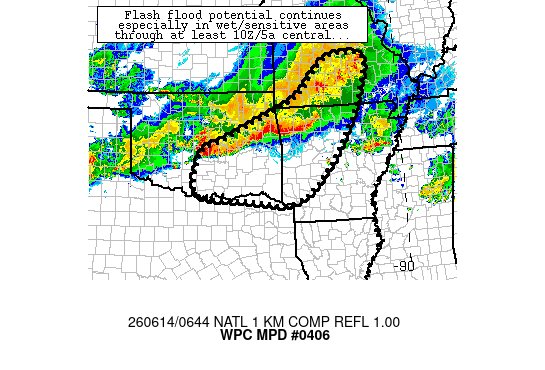
ALT graphic shows a still radar image across E. OK and NW AR this morning. Graphic has description on flooding threat through the remainder of the morning.
ALT graphic shows a still radar image across E. OK and NW AR this morning. Graphic has description on flooding threat through the remainder of the morning.
ALT A line of strong storms continues to push southward across eastern Oklahoma and western Arkansas. Localized areas may be occasionally severe early Sunday morning. Heavy rain and flash flooding will remain possible, too.

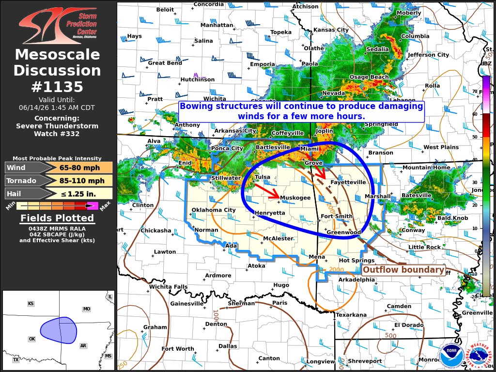
ALT A line of strong to locally severe thunderstorms capable of producing mainly wind gusts to 60 mph continues to move to the southeast early Sunday morning. Heavy rain and flash flooding will also be a concern. A Severe Thunderstorm Watch continues through 5 am.
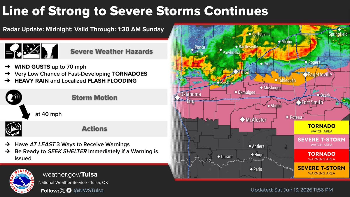
ALT A line of strong to severe thunderstorms continue to surge to the south and southeast across northeast Oklahoma and northwest Arkansas. Damaging winds and flash flooding potential are the greatest concerns, but isolated, fast-developing tornadoes could occur.

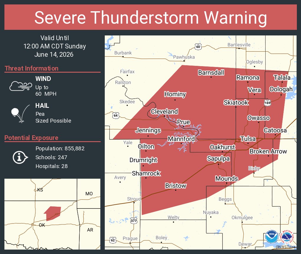
ALT This graphic displays a severe thunderstorm warning plotted on a map. The warning is in effect until 12:00 AM CDT. The warning includes Tulsa OK, Broken Arrow OK and Owasso OK. This warning is for Western Rogers, Southeastern Osage, Creek, Southern Washington, Northwestern Wagoner, Northwestern Okmulgee, Southeastern Pawnee and Tulsa Counties. The threats associated with this warning are wind gusts up to 70 MPH and pea sized hail. There are 850,354 people in the warning along with 243 schools and 28 hospitals.
ALT This graphic displays a severe thunderstorm warning plotted on a map. The warning is in effect until 11:30 PM CDT. The warning includes Miami OK, Commerce OK and Quapaw OK. This warning is for Northern Washington County Is Cancelled. The threats associated with this warning are wind gusts up to 70 MPH and pea sized hail. There are 29,729 people in the warning along with 26 schools and 2 hospitals.
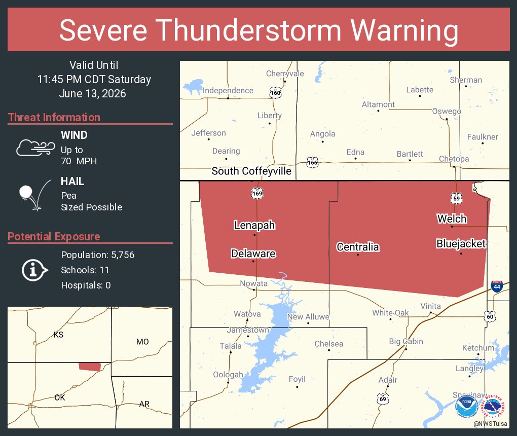
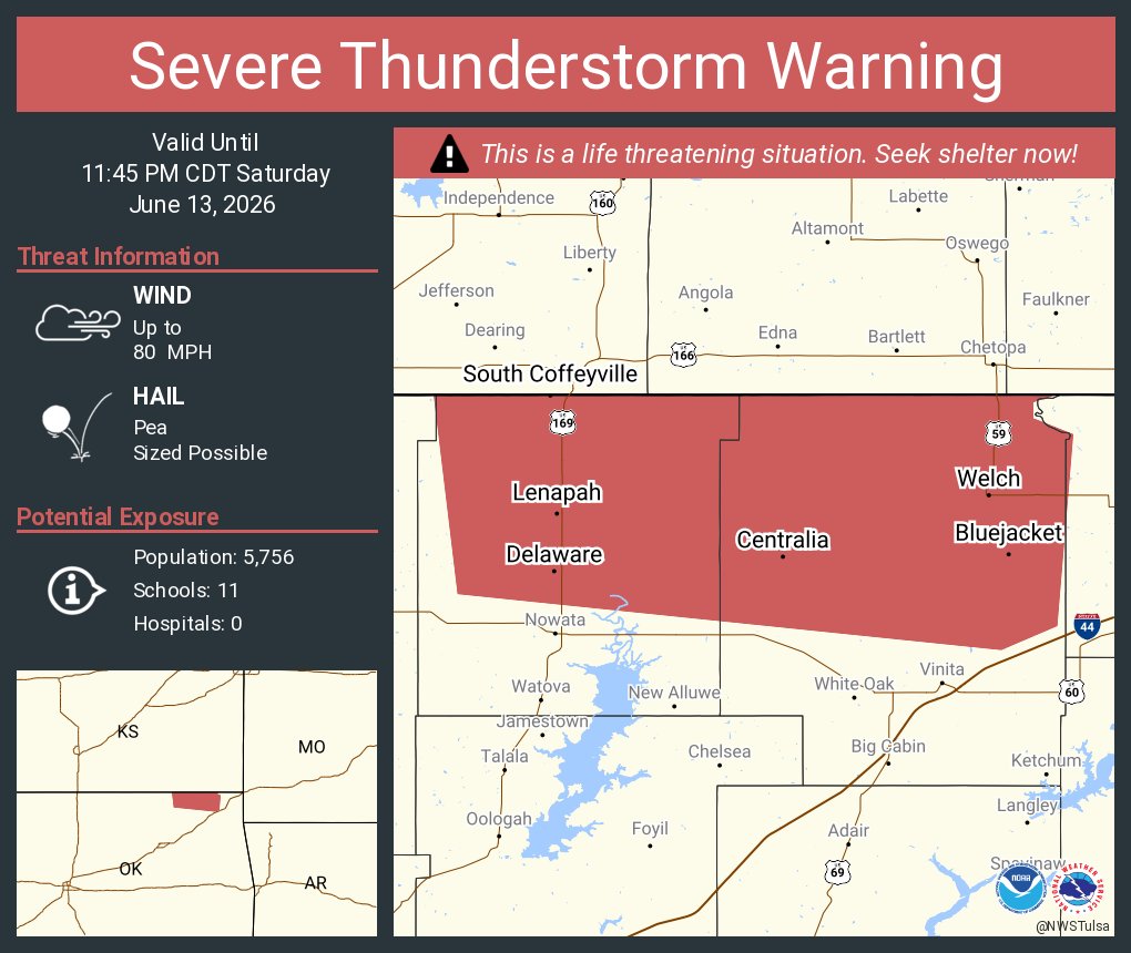
ALT This graphic displays a severe thunderstorm warning plotted on a map. The warning is in effect until 11:45 PM CDT. The warning includes South Coffeyville OK, Welch OK and Delaware OK. This warning is for Craig and Nowata Counties. The threats associated with this warning are wind gusts up to 70 MPH and pea sized hail. There are 5,756 people in the warning along with 11 schools and 0 hospitals.
ALT This graphic displays a severe thunderstorm warning plotted on a map. The warning is in effect until 12:00 AM CDT. The warning includes Claremore OK, Miami OK and Pryor OK. This warning is for Northwestern Benton County in northwestern Arkansas, Craig County in northeastern Oklahoma, Rogers County in northeastern Oklahoma, Delaware County in northeastern Oklahoma, Ottawa County in northeastern Oklahoma, Mayes County in northeastern Oklahoma and Southeastern Nowata County in northeastern Oklahoma. The threats associated with this warning are wind gusts up to 60 MPH and pea sized hail. There are 175,178 people in the warning along with 90 schools and 8 hospitals.
ALT This graphic displays a severe thunderstorm warning plotted on a map. The warning is in effect until 12:00 AM CDT. The warning includes Tulsa OK, Broken Arrow OK and Owasso OK. This warning is for Western Rogers County in northeastern Oklahoma, Southeastern Osage County in northeastern Oklahoma, Creek County in northeastern Oklahoma, Southern Washington County in northeastern Oklahoma, Northwestern Wagoner County in northeastern Oklahoma, Northwestern Okmulgee County in northeastern Oklahoma, Southeastern Pawnee County in northeastern Oklahoma and Tulsa County in northeastern Oklahoma. The threats associated with this warning are wind gusts up to 60 MPH and pea sized hail. There are 855,882 people in the warning along with 247 schools and 28 hospitals.
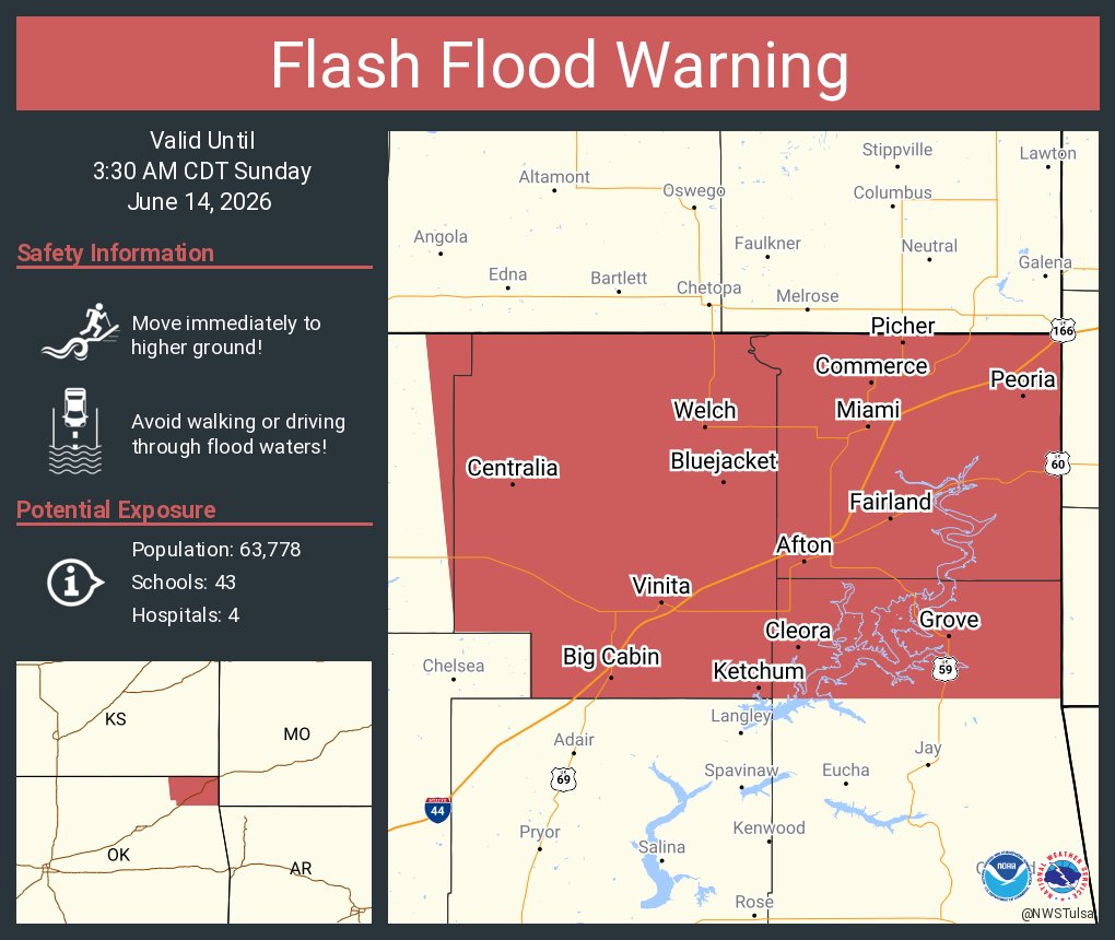
ALT This graphic displays a flash flood warning plotted on a map. The warning is in effect until 3:30 AM CDT. The warning includes Miami OK, Grove OK and Vinita OK. This warning is for Craig County in northeastern Oklahoma, Northern Delaware County in northeastern Oklahoma, Northeastern Nowata County in northeastern Oklahoma and Ottawa County in northeastern Oklahoma. Avoid walking or driving through flood waters! Move immediately to higher ground! There are 63,778 people in the warning along with 43 schools and 4 hospitals.
ALT This graphic displays a severe thunderstorm warning plotted on a map. The warning is in effect until 11:45 PM CDT. The warning includes South Coffeyville OK, Welch OK and Delaware OK. This warning is for Craig County in northeastern Oklahoma and Nowata County in northeastern Oklahoma. The threats associated with this warning are wind gusts up to 80 MPH and pea sized hail. There are 5,756 people in the warning along with 11 schools and 0 hospitals.
ALT This graphic displays a severe thunderstorm warning plotted on a map. The warning is in effect until 11:15 PM CDT. The warning includes Bartlesville OK, Sand Springs OK and Skiatook OK. This warning is for Osage, Northern Creek, Southern Washington, Pawnee and Northwestern Tulsa Counties. The threats associated with this warning are wind gusts up to 70 MPH and pea sized hail. There are 120,162 people in the warning along with 71 schools and 7 hospitals.
ALT This graphic displays a severe thunderstorm warning plotted on a map. The warning is in effect until 11:30 PM CDT. The warning includes Miami OK, Commerce OK and Quapaw OK. This warning is for Craig County in northeastern Oklahoma, Ottawa County in northeastern Oklahoma, Northern Washington County in northeastern Oklahoma and Nowata County in northeastern Oklahoma. The threats associated with this warning are wind gusts up to 70 MPH and pea sized hail. There are 31,402 people in the warning along with 28 schools and 2 hospitals.

ALT This graphic displays a severe thunderstorm warning plotted on a map. The warning is in effect until 11:15 PM CDT. The warning includes Bartlesville OK, Sand Springs OK and Skiatook OK. This warning is for Osage County in northeastern Oklahoma, Northern Creek County in northeastern Oklahoma, Southern Washington County in northeastern Oklahoma, Pawnee County in northeastern Oklahoma and Northwestern Tulsa County in northeastern Oklahoma. The threats associated with this warning are wind gusts up to 70 MPH and penny sized hail. There are 120,525 people in the warning along with 71 schools and 7 hospitals.

ALT This graphic displays a severe thunderstorm warning plotted on a map. The warning is in effect until 10:45 PM CDT. The warning includes Pawnee OK, Fairfax OK and Ralston OK. This warning is for West Central Osage and Western Pawnee Counties. The threats associated with this warning are wind gusts up to 70 MPH and penny sized hail. There are 5,052 people in the warning along with 6 schools and 2 hospitals.