
Mostly aviation safety, with an appearance on Mayday - ACI: deviations include auto racing, true crime, and whatever I feel like.
Joined March 2019
- Tweets 262,400
- Following 1,990
- Followers 70,819
- Likes 185,534
56,529 Photos and videos


Pinned Tweet

Apr 9
New Zealand Air Force Bell UH-1 engine start. (Can any chopper expert explain why he is holding one of the rotors before he "cranks" it?)
📹helicopters_action
1,072
475
10,297
6,466,974
Francisco Cunha retweeted

The Law of Conservation of Energy states that energy can neither be created nor destroyed.
It can only change forms.
That 380 has a lot of Kinetic Energy.
1/2 * m * V^2.
m=Mass (at time of RTO)
V=Ground Velocity (at time of RTO)
In bringing that airplane to a halt, that Kinetic Energy gets converted to Heat Energy & stored in the Brake Disks.
x.com/OnDisasters/status/206…
3
2
22
841
The first air loss of the Russian Invasion of Ukraine?
June 14 2014: a Ukraine AF Il-76 [Reg.”76777”] is shotdown in Lugansk (Ukraine). All 49 aboard die. On approach, jet was hit by a missile fired by pro-Russian rebels. Attack occurred during a period of civil unrest in the country, known as the “War on Donbass”, before the 2022 invasion.
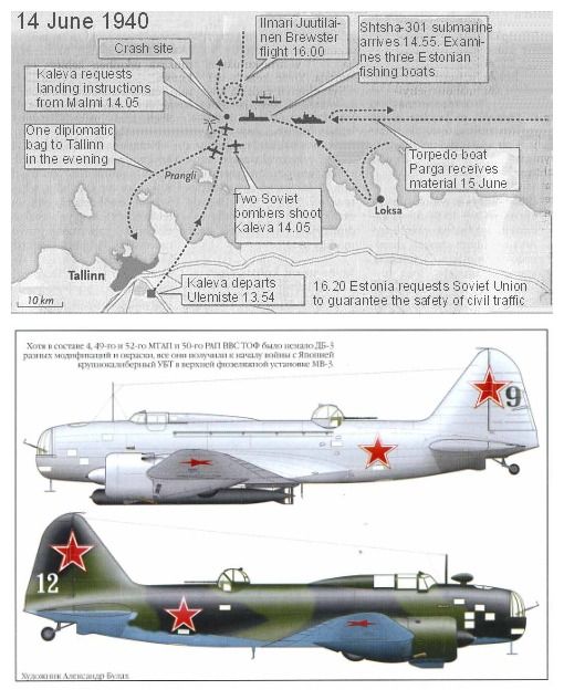
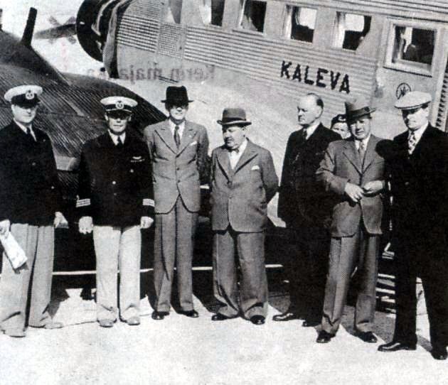
And also on this date.. another Russian shotdown
1940: “Kaleva” shotdown: Aero O/Y Flight 1631, a Ju-52 [OH-ALL, “Kaleva”] is shot down by Russian AF DB-3´s in the Gulf of Finland, all 9 aboard die. Attack was likely fallout of USSR´s preparations for invading Estonia: at the time Russia and Finland were not at war.
More June 14 occurrences below 1/5 🧵 ⬇️

1
3
342
1945: a USAAF C-46 [44-77948] crashes in Mississippi (US). Of 18 aboard, 1 survivor. On approach to Jackson Airport, at 3000 feet, the aircraft was hit by lightning. The captain was unable to maintain control of the airplane, which went down in a wooded area.
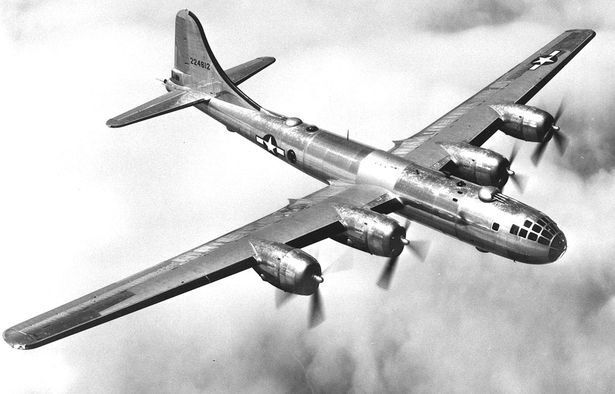
1947: a USAF B-29 [44-62228] crashes in Vermont (US) all 11 aboard die. The aircraft was on a training mission, flying at night. Reportedly, due to bad weather and poor visibility, the crew became lost and impacted Hawks Mountain. It remains the deadliest air crash in Vermont. 🧵 ⬇️ 4/5

1
205
1981: Aeroflot Flight 498, an Il-14, crashes in Buryatia (Russia). All 48 aboard die. On descent in bad weather, plane impacted a mountain 18 mi from airport. Cause: crew breach of SOP during maneuver, causing the aircraft to deviate from the route.
1917: German Navy Zeppelin LZ 92 [Registration “L43”] is shotdown off Vlieland (Friesland, Netherlands). Airship was on a patrol over the North sea when it was spotted by a British (RNAS) Curtiss H.12 flying boat, whose gunner shot it down with machine gun fire.
#OTD in 1934: prototype bomber Curtiss XSBC-1 [9225], intended for the US Navy, crashes in New York (US). Plane had wing failure during flight testing. Project will carry on and after a redesign, it will enter service as SBC "Helldiver" in 1938. (Anyone knows if pilot survived?) 🧵 ⬇️ 5/5


188
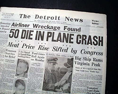
The controversial JAL crash in India – Flight 471 accident was 54 years ago
June 14, 1972- Japan Air Lines Flight 471, a DC-8, crashes in Delhi (India). 82 of 87 aboard and 4 on the ground die.
On approach to New Delhi airport, at night, the aircraft impacted the ground on a CFIT – Controlled Flight into Terrain – in an urban area 13 miles from the runway.
Indian investigators blamed the pilots, pointing to “total disregard of laid-down procedures by the crew and abandoning all instrument indications without properly ensuring sighting of the runway.”
On the other hand, Japanese staff assessing the enquiry stated “a false glide path signal to be responsible for the premature descent into terrain”.
The video seen here is an extract from a Japanese Documentary on the accident, showing a reconstruction of the accident using the CVR recording – you can find the full video as “CVR Audio | Last cockpit voice recording of Japan Airlines Flight 471” user - おみず
I should also warn that there is aftermath footage of the occurrence, but I warn that it also features graphic footage
5
18
2,533
Francisco Cunha retweeted

It’s 2,136 nautical miles from PHNL to KSFO, almost all of it over water.
What happens if we have an emergency?
The simple answer is that we’ll either turn back to HNL or continue to SFO, whichever is closest. To decide, we take into account the winds, assuming we have to descend to 10,000’ & drop a point where it’s an equal amount of time to either. If past the point, continue to SFO. Otherwise, turn around.
This is called our “CP” or “Critical Point”. It’s also sometimes called an “Equal Time Point”. It shifts from day to day, based on the winds, but out of the islands it’s usually at around 140° West. That’s about halfway in terms of mileage; the Coast Guard used to put a ship there in the early days, known as “Ocean Station November”. It served as a weather ship, had a beacon for navigation & was on standby for rescues at 30° North, 140° West.
(PanAm 6 did ditch near the Cutter once in 1956, with all aboard surviving)
Today, the Cutter is no longer there. Also, our CP is a little West of the mid point in terms of miles, because the winds are a light tailwind. If the winds were stronger, it would be even further West, because turning around means we have to battle a headwind now, slowing us down.
LAX is actually further from HNL at 2,217 nm, where SFO is 2,081 nm because it’s further West than LAX, so SFO is our best bet.
Hope that helps!


44
17
470
19,810
Francisco Cunha retweeted

A US Navy F/A-18 crashed near Rimrock Lake, pilot ejected and walked out with medics according to reports. This is along the famous VR-1355 low level route in Washington State.
🎥509Media
45
93
752
143,828
Francisco Cunha retweeted
This was one of the first videos I saw on the Internet back in 2003 or so.
The description from Syd Watkins - the F1 resident Doctor - is a hard read - likely more than this footage (which, believe it or not, aired regularly on mainstream TV, I later found it on VHS tape about F1).
To make it even worse, it was Paletti´s "debut" (he had started a race before, but with a depleted grid) and his mother was on the pit lane and saw everything unfold.

Remembering the tragic death of Riccardo Paletti, who died #OnThisDay 13 June 1982. A death that overshadowed Brabham driver Nelson Piquet‘s victory at the 1982 Canadian Grand Prix.
The race began with Didier Pironi‘s Ferrari stalling on the front row, prompting him to signal the approaching drivers. Although many drivers swerved to avoid Pironi, Paletti, in the Osella, starting from the back in only his second Grand Prix start, collided with Pironi’s stationary car at high speed. The impact caused Pironi’s car to shift left, while Paletti’s car stopped where it crashed, crushing the nose of his car. Rescuers, including Pironi and FIA doctor Sid Watkins, rushed to help, but Paletti’s car caught fire. It took nearly a minute to extinguish the flames and another 25 minutes to extract him. Paletti succumbed to severe chest and abdominal injuries. This was Formula 1’s last fatality until the tragic weekend at Imola in 1994.
Piquet’s teammate Riccardo Patrese finished second, with John Watson third in a McLaren.
#f1 #formula1


19
73
1,054
476,564
Francisco Cunha retweeted

OTD in 1952 we shot down a Swedish Air Force DC-3 in international airspace. Later in the day we shot down a search & rescue plane looking for it
We denied it until 1991.
19
397
2,435
66,343

Pode colocar #EXCLUSIVO de novo!
Com diversidade na linha de montagem, veja quais aviões KC-390 da Embraer serão entregues em breve
aeroin.net/com-diversidade-n…
1
7
113
3,347
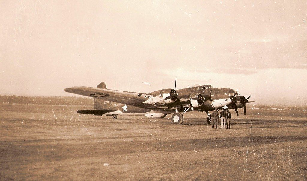
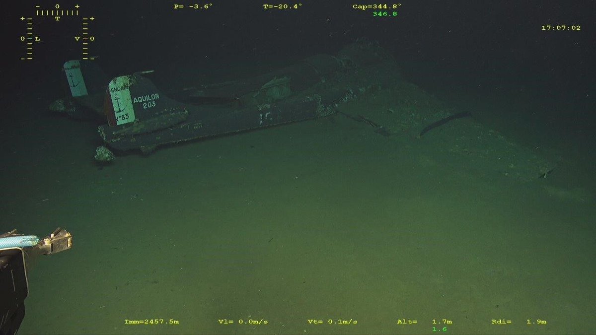
55 years today – The vanishing EC-135
13 June 1971 - a USAF C-135B with 24 aboard disappears somewhere off Hawaii (US). Only light wreckage was found floating in the ocean. Officially, the cause of the accident was never revealed.
Some sources state the likely cause was a structural failure due to modifications in the airframe – seen in the black sections on the front of the fuselage. These conversions had been implemented for the jet´s mission that day, which was to observe French nuclear tests in Moruroa, specifically to "detect and analyze nuclear explosions and their related electromagnetic pulses" (via Code 7700).
The aircraft [Registration 61-0331] was assigned to the 4950th Test Wing, Space and Missile Systems Organization (SAMSO), Wright-Patterson AFB, and was en route from Pago Pago, American Samoa, to Hickam AFB in Hawaii after monitoring the French atmospheric nuclear test Encelade. It is estimated that it vanished some 70 miles south of Hawaii, near Palmyra Island. Of the 24 aboard, 12 were civilians and the others civilian technicians.
1
7
63
3,463
Francisco Cunha retweeted
Jun 13
The Spitfire-powered helicopter (sort of)
June 13 1950: 1st prototype of the Cierva W.11 “Air Horse”, a 3-rotor heavy helicopter [G-ALCV] crashes in Hampshire (England). All 3 aboard die, cause traced to a mechanical issue. The W.11 was, at the time, the world´s largest helicopter. The project was later cancelled.
Footage seen here from the 1949 Farnborough Air Show, where the W.11 performed a flying display
The Air Horse was unusual for using three rotors mounted on outriggers and driven by a single engine mounted inside the fuselage. And for those wondering about the Spitfire reference, that´s because it used the same engine: the famous RR Merlin.
More info here, from D. Donald's book - The Complete Encyclopedia of World Aircraft",
“The Cierva W.11 Air Horse first flew on December 7, 1948, as the world’s largest helicopter. Powered by a fuselage-mounted 1208 kW Rolls-Royce Merlin 24 engine, it featured a unique three-rotor configuration on external outriggers and carried a three-person crew. Initially designed for 24 passengers, the aircraft was modified for agricultural spraying, air ambulance, and heavy-lift roles.
Following a 1945 consultation with Pest Control Ltd, the design was adapted to carry a 3048 kg insecticide payload. This resulted in a Ministry of Supply contract for two prototypes, built by Cunliffe-Owen Aircraft under Cierva's technical control. The program attracted financial backing from both the Ministry of Supply and the Colonial Office, which viewed the helicopter as a promising tool for overseas crop spraying.
The development ended tragically when the first prototype crashed on June 13, 1950, killing all three crew members. Consequently, the second prototype was grounded and eventually scrapped in 1960. Planned variants—including the twin-engine W.11T and the Dart turboprop-powered W.12 freighter—were abandoned as Cierva shifted focus to the smaller W.14 Skeeter, later produced by Saunders-Roe.”
1
14
67
5,923
Francisco Cunha retweeted
Jun 13
True crime 🔍🔫🪓
What a time to be alive: Filmrise put up full seasons of the series “Forensic Files” on YouTube, just a click away from proper true crime documentaries (no AI slop or narration here)
Here´s a part of the very first episode, and one with a tiny aviation angle — the disappearance of Helle Craft. Not to give too many spoilers, but if you don´t know the story, it inspired a very famous scene in the movie "Fargo".
1
1
4
1,627
Francisco Cunha retweeted
Jun 12
Warming up For Le Mans 😍 Volume up (love seeing that Porsche exhausts spitting flames when it up shifts)
1
22
1,876
Francisco Cunha retweeted
Jun 12
Besides all the other accidents mentioned today (the Air India B-787, the Windsor incident, and the SU-30 crash in 99 Paris Air show), this date of June 12 is marred by a series of other occurrences, some of which are listed on this thread here 1/5🧵 ⬇️
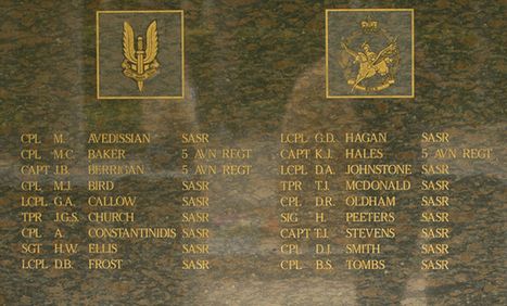
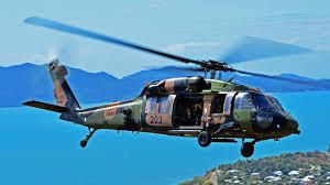
1996: two Australian Army S-70s collide in Queensland (Australia), 18 of 28 aboard both choppers die. On a nighttime training operation involving 6 helicopters, the first S-70s in the formation collided. Exercise involved the Army Aviation Corps and SAS Regiment.

2
7
39
3,536
Francisco Cunha retweeted
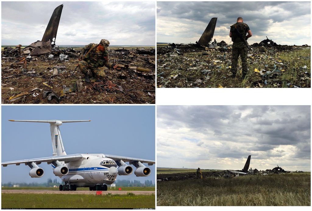
Today - Indian Air Force An-32 crashed at Assam (India). Only 1 survivor of 6 aboard. Accident occurred attempting to land at Jorhat Air Force Base. Plane registration is "KA2678". 📹Abbas Ranganathan
1
2
23
2,612
Francisco Cunha retweeted

Jun 13
This is a lie. Chappie James is indeed a revered hero in Air Force history but his portrait was NOT taken down. It was relocated to another wall in the Pentagon in a more prominent display.
Jun 12

Hegseth removed Chappie James's portrait from the Air Force Art Gallery and left the wall empty.
James flew 179 combat missions across two wars. First Black four-star general in US military history.
Curry passed that portrait every day for a decade. When it came down, he retired.
The wall is still empty.

101
1,525
5,259
46,498
Francisco Cunha retweeted
Jun 13
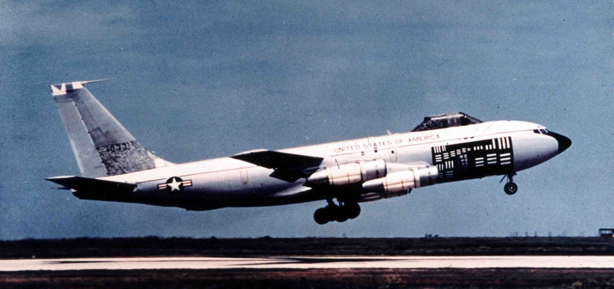
Whale throwing the anchors - A380 Maximum Energy Rejected Takeoff Test, in Istres (France) in 2007
(...) “For the unique max energy RTO test, performed at MTOW, the aircraft demonstrates the capacity to absorb the certified max energy into the brakes. Regulatory conditions require that tyres must all be in 90% plus worn condition and, for a successful test, no intervention by the fire crews is allowed for a period of 5 minutes post RTO” (...) From the Airbus Site – video is from Safety First Magazine
5
15
94
13,028