Our mission is to develop and share cutting-edge earthquake system science to enhance California’s resilience and to educate and inspire future scientists.
California nonprofits, schools, agencies, tribes & community groups can improve safety with a 2026 @Cal_OES "Secure Your Space" Project. Selected applicants receive up to $500 in earthquake fasteners, installation guidance from @ECA! Apply by June 18: EarthquakeCountry.org/syspro…
2026 @Cal_OES "Secure Your Space" Projects, coordinated by @ECA, help California nonprofits, schools, and other groups secure items that might fall during earthquakes. Projects receive fasteners worth $500, plus installation support! Apply by June 18 at earthquakecountry.org/syspro…
Between May 25 (12:00 AM PST) and May 31 (11:59 PM) there were 61 earthquakes in California of magnitude 2.0 or larger.
🔸56 quakes between M2.0 - 2.9
🔸5 quakes between M3.0 - 3.9
The largest earthquake was a magnitude 3.9 W of Petrolia, CA.
cadoc.maps.arcgis.com/apps/d…
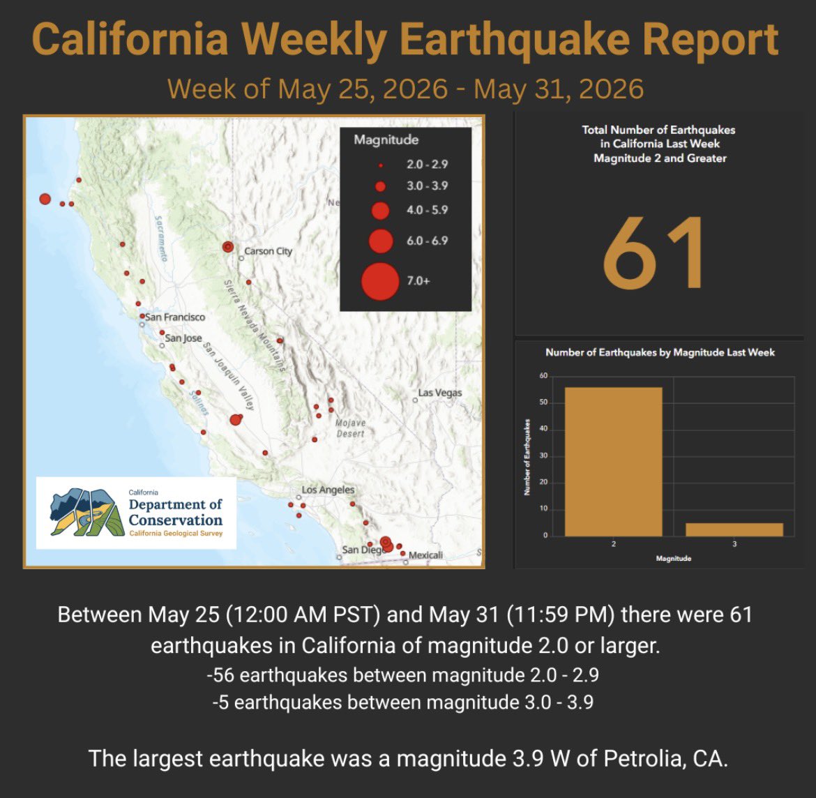
ALT Infographic showing a map of California with earthquakes on the left and a bar graph with the number of each magnitude of earthquake on the right.
Between May 4 (12:00 AM PST) and May 10 (11:59 PM) there were 183 earthquakes in California of magnitude 2.0 or larger.
🔸153 earthquakes of M2.0 - 2.9
🔸25 earthquakes of M3.0 - 3.9
🔸5 earthquakes of M4.0 - 4.9
The largest quake was a M4.9 WSW of Crescent City, CA
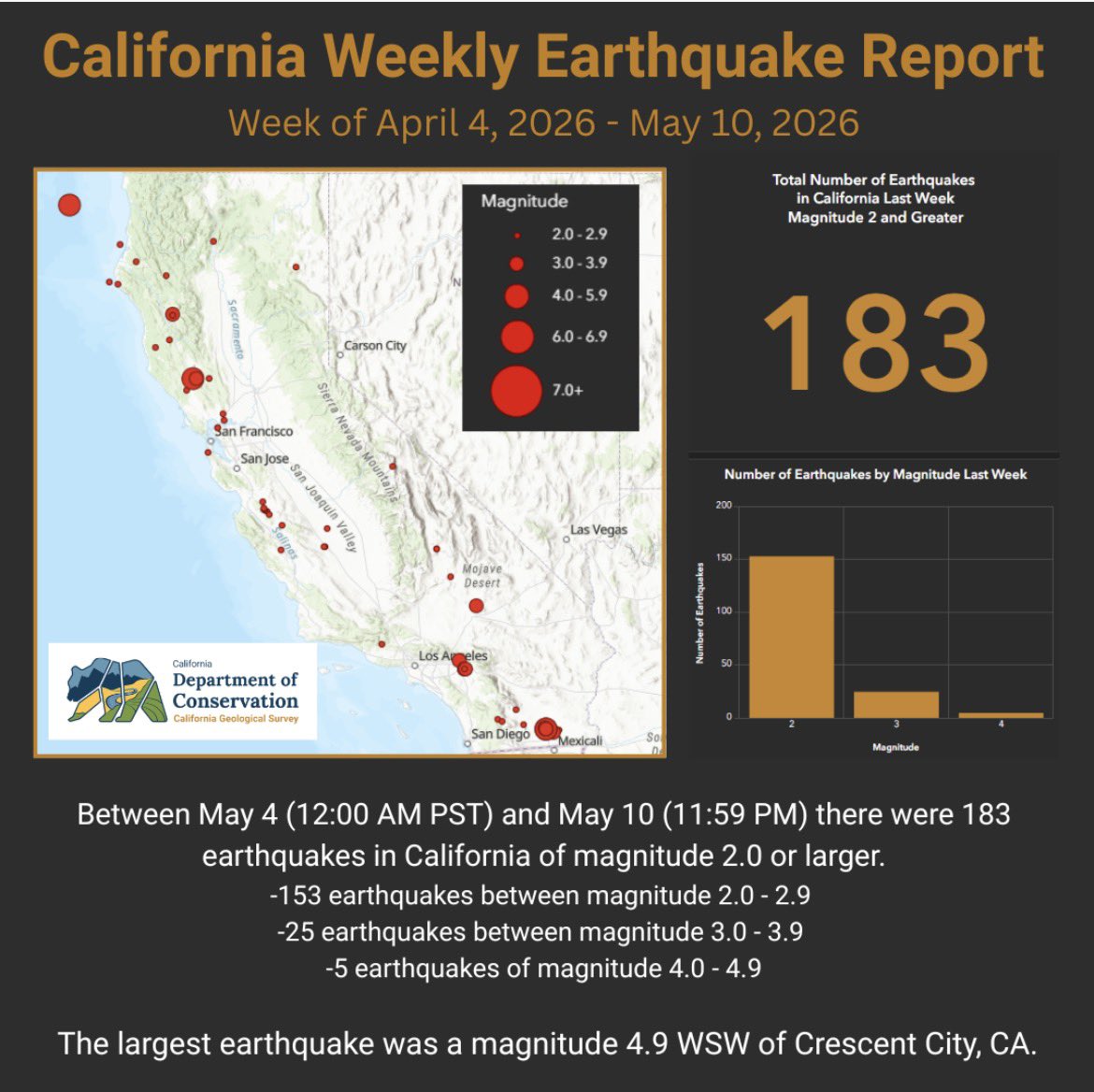
ALT Infographic showing a map of California. Dots show the location of earthquakes and the size of the dot indicates the earthquake magnitude. On the right is a bar graph showing the number of earthquakes of each size.
🫸 Drop! Cover! Hold on!
If the ground starts shaking & you're indoors, this reflex can protect you.
Run a Drop, Cover, Hold On drill – & make it a habit. The reflex it builds can last a lifetime.
➡️ ow.ly/8L5150YQsu2#BuildingResilience#EarthquakeDay#DropCoverHoldOn
"Earthquakes are one of nature's deadliest hazards. In seconds, they can turn homes into ruins, undo decades of progress & claim thousands of lives." - Guterres
Most earthquake deaths result from collapsing buildings ➡️ ow.ly/W1ZM50YR6Jj#EarthquakeDay#BuildingResilience
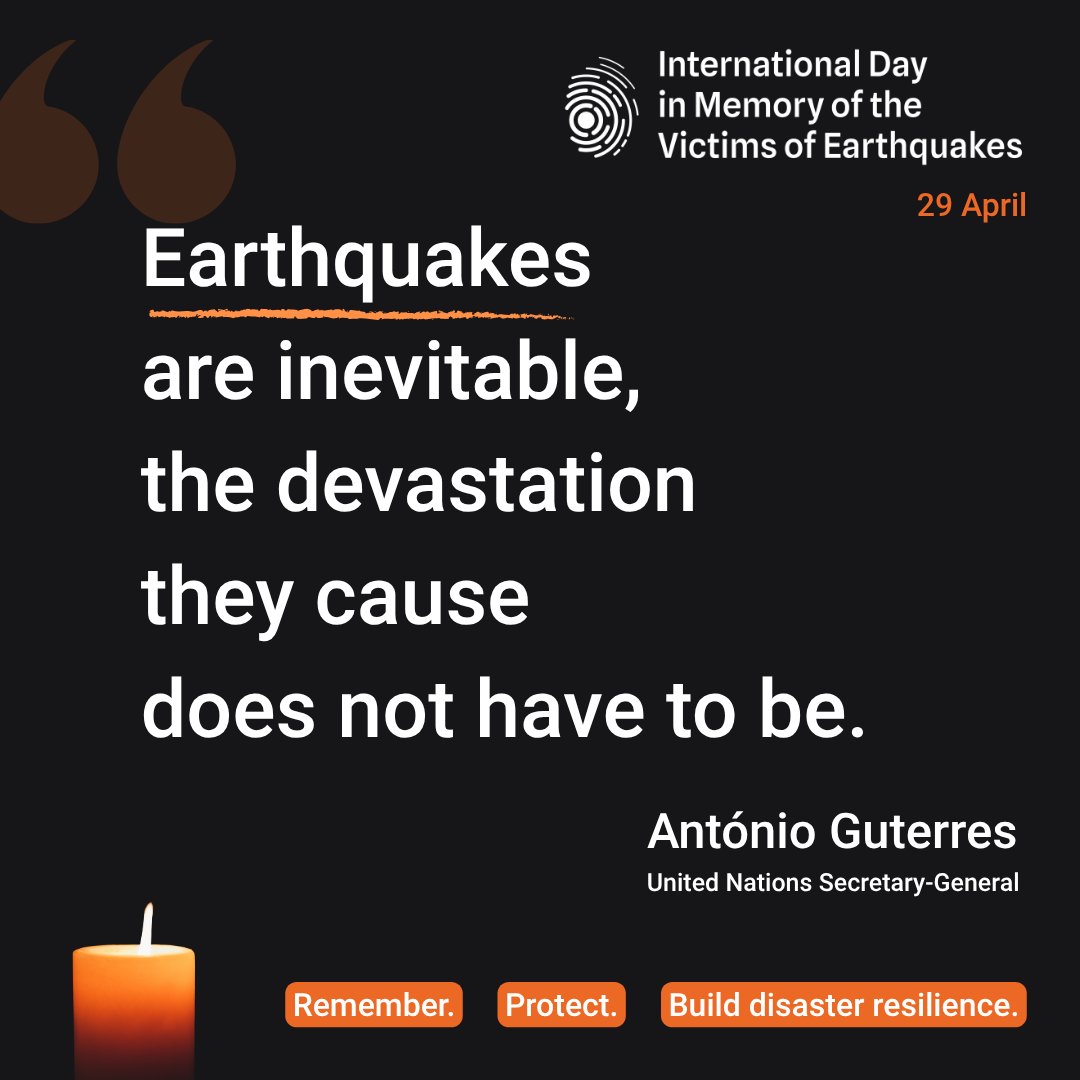
ALT Quote by António Guterres on earthquakes emphasizing inevitability but preventable devastation for International Day in Memory of Earthquake Victims.
As the global home for Great @ShakeOut Earthquake Drill coordination, @SCEC encourages support and awareness of this important new annual day to Remember, Protect, and Build Disaster Resilience.
We are proud of the new partnership between @UNDRR and @ShakeOut to observe this new #EarthquakeDay and to encourage everyone, everywhere to learn and practice earthquake safety actions such as #DropCoverHoldOn during annual earthquake drills. Learn more: ow.ly/8L5150YQsu2
📢 Smart public policies can prevent earthquake disasters.
Most earthquake deaths result from damage to buildings & infrastructure – we can protect people from this.
🕯️ Remember. Protect. Build disaster resilience.
➡️ ow.ly/Ie8o50YQwTC#BuildingResilience#EarthquakeDay
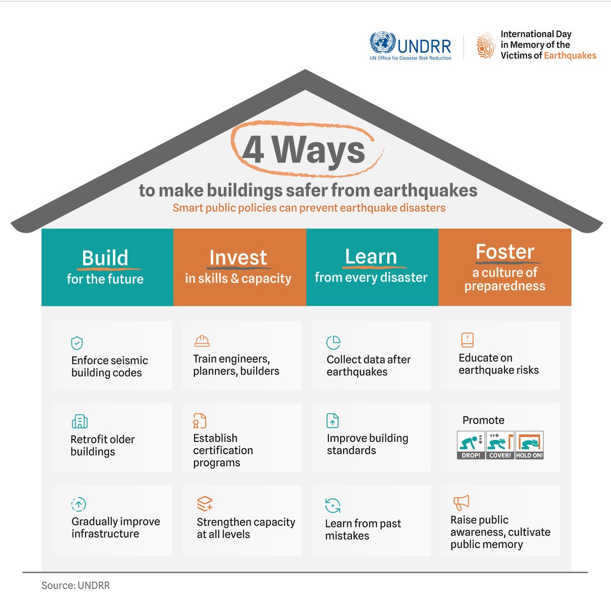
ALT Infographic showing 4 ways to make buildings safer from earthquakes: Build, Invest, Learn, and Foster preparedness with specific actions under each category.
Between April 13 (12:00 AM PST) and April 19 (11:59 PM) there were 28 earthquakes in California of magnitude 2.0 or larger.
🔸26 earthquakes between magnitude 2.0 - 2.9
🔸2 earthquakes between magnitude 3.0 - 3.9
The largest earthquake was a magnitude 3.5 near Ludlow, CA.
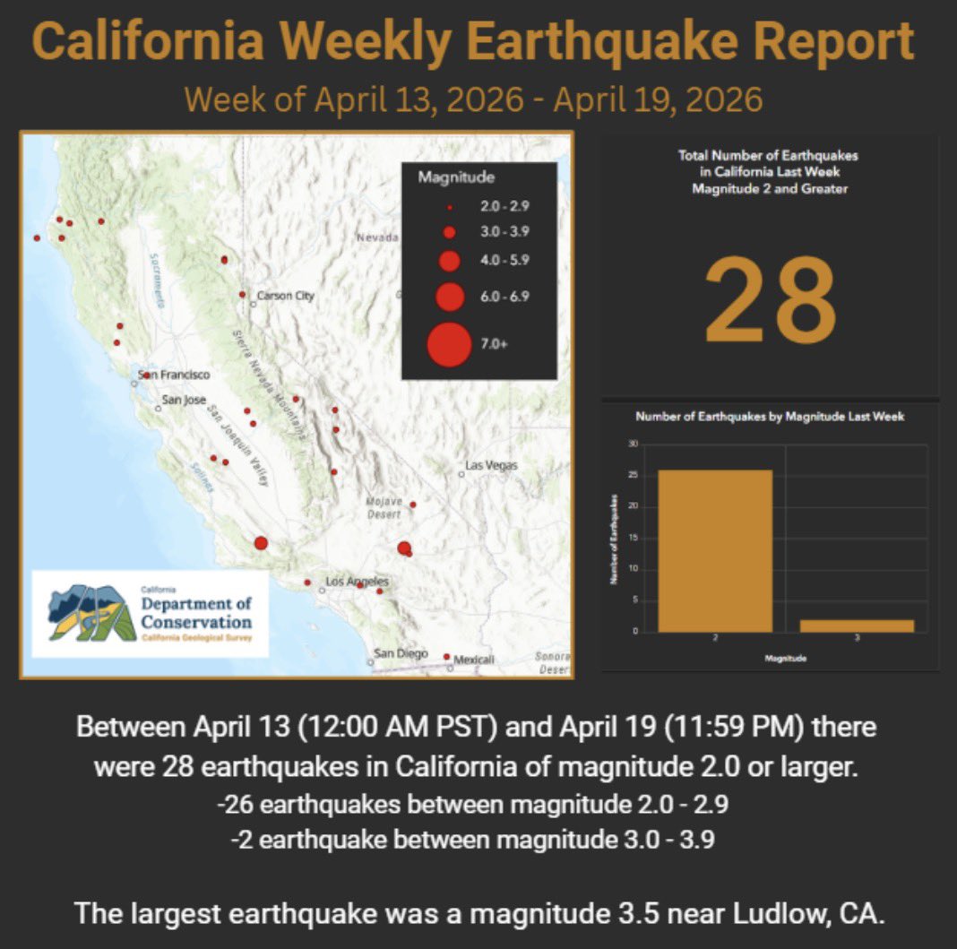
ALT Infographic showing a map of California. Earthquakes are indicated by red circles of various sizes. On the right side is a bar graph showing the number of earthquakes of different magnitudes
Between April 6 (12:00 AM PST) and April 12 (11:59 PM) there were 39 earthquakes in California of magnitude 2.0 or larger.
🔸38 earthquakes between magnitude 2.0 - 2.9
🔸1 earthquake between magnitude 3.0 - 3.9
The largest earthquake was a magnitude 3.2 near Trinidad, CA.
ALT Infographic with a map of California showing the location of earthquakes, marked by red dots. The size of the dot gives the relative size of the earthquake. There is also a bar graph showing the number of quakes in each magnitude range.
Reminder: ECA’s free Statewide Webinar is tomorrow, March 18, from 10am-12pm PT. Join us for updates from ECA and partners, plus information on California tsunami hazards and how to get ready ahead of Tsunami Preparedness Week. Register: EarthquakeCountry.org/event/…
Join us for the free ECA Statewide Webinar on March 18, 10am-12pm PT. Get updates from ECA and partners, plus an overview of California tsunami hazards and safety steps ahead of Tsunami Preparedness Week. Register: EarthquakeCountry.org/event/…
California had damage from this tsunami, especially along the north coast. Everyone can take actions to be prepared (& practice what to do if along the shore) by participating in California's Tsunami Preparedness Week (March 21-29)- visit tsunamizone.org/california to learn more.
On March 11, 2011, Japan faced a catastrophic M9.1 earthquake which triggered a devastating tsunami along Japan’s coastline. Fifteen years later, we remember the victims and the importance of being prepared. Learn more about the science and safety here: oceantoday.noaa.gov/tsunamis…
Today marks the 32nd anniversary of the 1994 Northridge earthquake. The M6.7 quake beneath the San Fernando Valley became the costliest U.S. natural disaster until Hurricane Katrina (2005). Learn more: EarthquakeCountry.org/northr…
Want to keep up to date with SCEC news, events, and jobs? Then sign up for our newsletter by going to the bottom of the new SCEC website to stay in the loop!
@NSF@USGS@USC@USCDornsife
Missed a recent SCEC workshop or annual meeting session? Many presentations and recordings are now listed on our Events pages. Catch up and share with colleagues at SCEC.org/events.
SCEC bridges the gap between cutting-edge science and preparedness for a more resilient California, through education, research, and more realistic earthquake simulations. Learn more at: SCEC.org/prepare.
SCEC engages stakeholders across geoscience and related fields through workshops, drills, and collaborations to advance earthquake science, education, and preparedness. Find out more at: SCEC.org/community.
The SCEC community comes together to amass data that can facilitate the research of the San Andreas Fault System. View our Community Earth Models and learn more at SCEC.org/earthquake-system-s….