#Sentinel3 satellite #altimetry data show the result of #Kakhovka dam destruction: between June 6 and 8, the water level dropped by >4 meters. Current satellite-based water levels of reservoir & #Dnieper are freely available in @DgfiTum's DAHITI database (dahiti.dgfi.tum.de/)
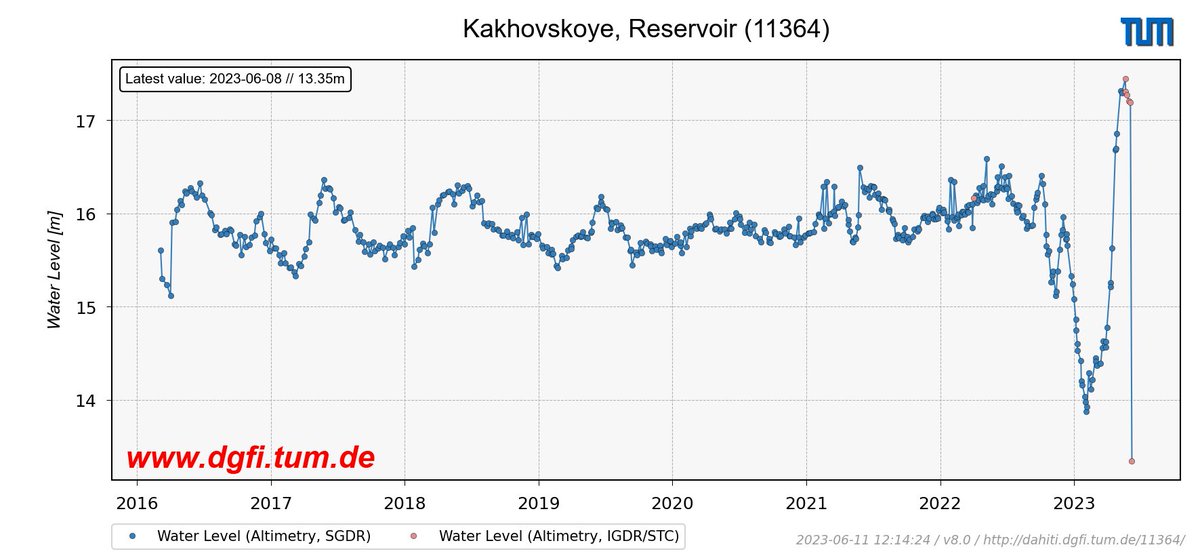
ALT https://dahiti.dgfi.tum.de/en/11364/water-level-altimetry/
Fully focused SAR processing of #Sentinel6#altimetry data was shown to improve the accuracy of coastal Significant Wave Height (SWH) estimates in the #NorthSea. From the measurements, a 26.4% decay in SWH can be inferred between 30 km and 1 km offshore: doi.org/10.1016/j.rse.2023.1…
Data-driven interpolation of sparse along-track #altimetry data with Random Forest Regression leads to improved characterization of #SeaLevel variability. This is shown by a case study for the #NorthSea in comparison to conventional optimal interpolation: doi.org/10.1007/s10236-023-0…
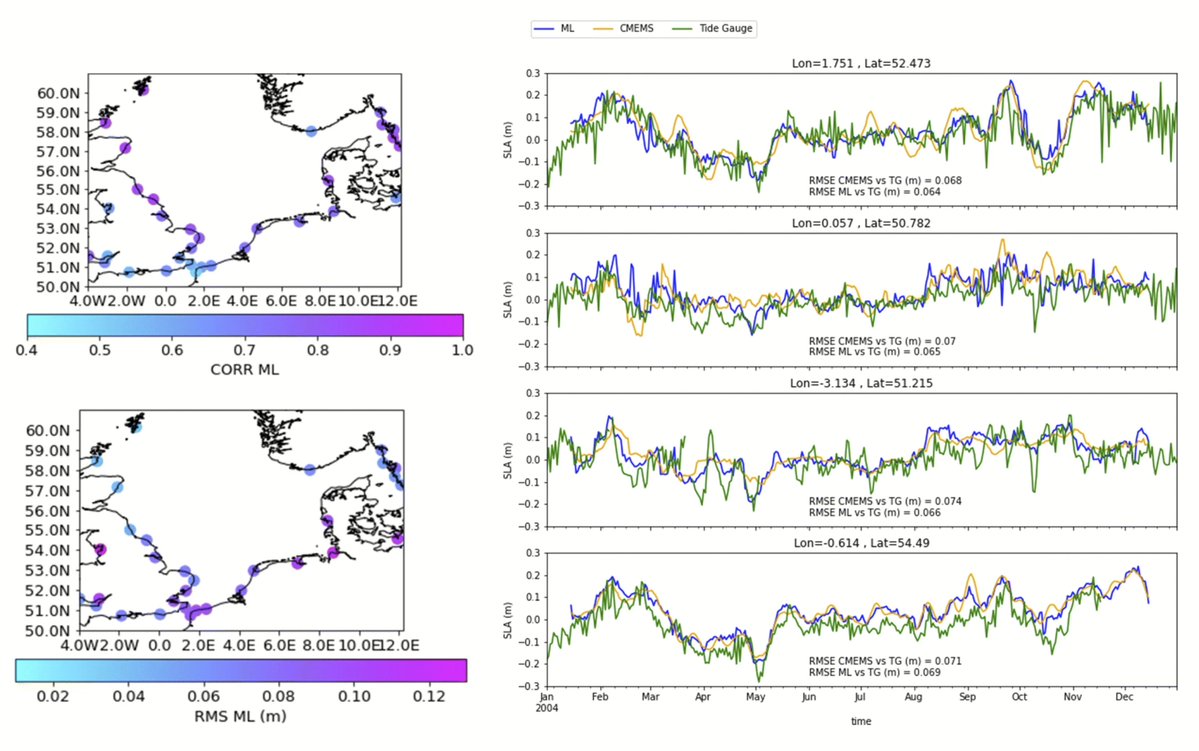
ALT Left: Correlation coefficients and root mean square differences between sea level anomalies (SLA) from the study, using the machine learning (ML) technique of Random Forest Regression for altimetry data gridding. Right: SLA time series from satellite altimetry using data-driven interpolation (blue, ML) in comparison with CMEMS data (orange, using conventional optimal interpolation) at the closest point to four tide gauges (green), whose coordinates are shown at the top of each panel. Recognizably, high-frequent sea level variability is better reproduced by the ML-based time series.
Thin sea ice plays an important role in sea ice production, ventilation & heat exchange between polar ocean and atmosphere. A study highlights how #CryoSat2 SAR #altimetry can reliably monitor thin ice and open water at high spatial & temporal resolution: doi.org/10.5194/tc-17-809-20…
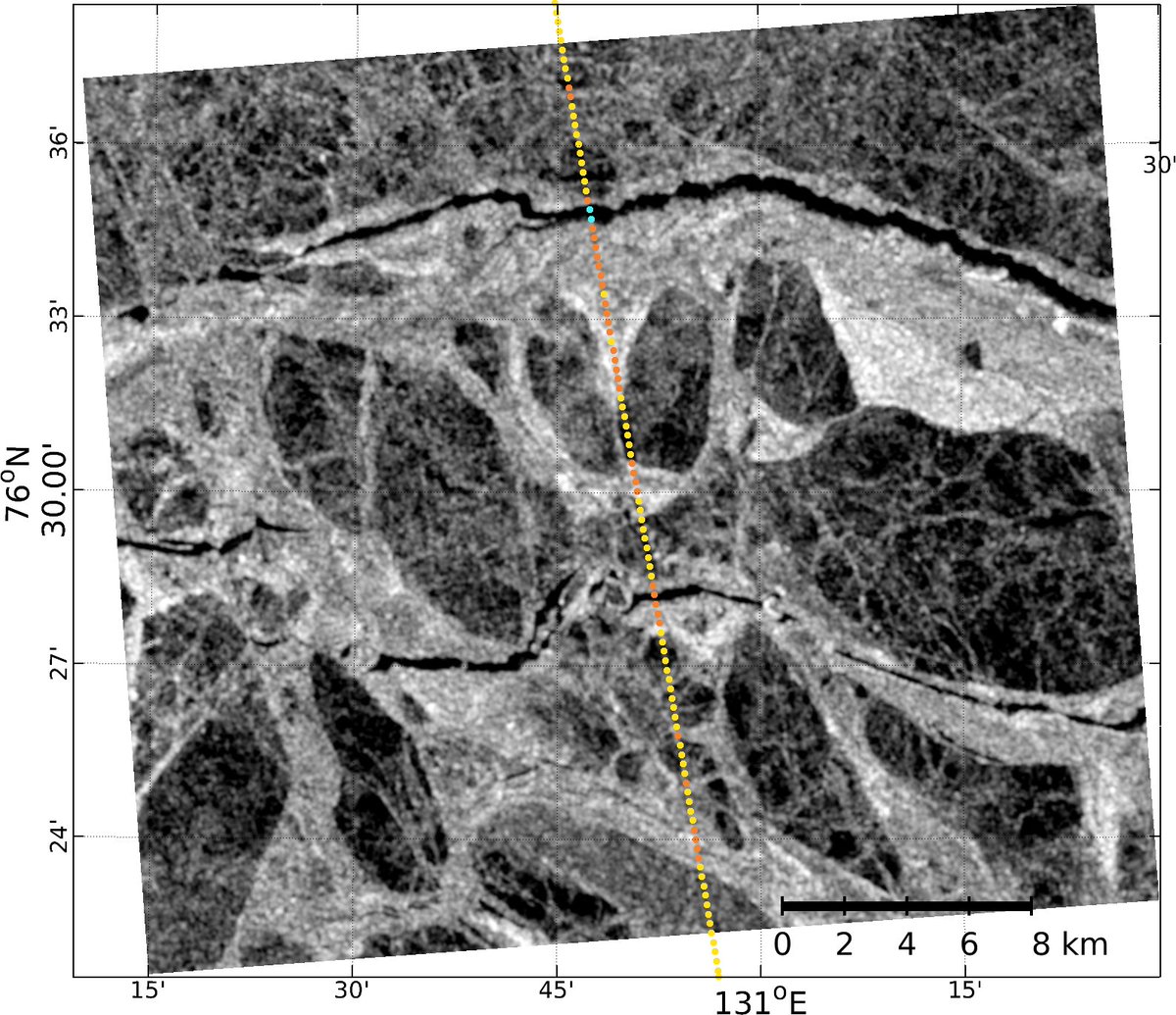
ALT Classified CryoSat-2 observations versus HH-polarized Sentinel-1A image (Laptev Sea, February 2018): Detection of thin-ice (orange), sea ice (yellow) and leads (cyan).
Systematic errors in #SeaLevel trends can occur if measurements of #altimetry satellites are not properly corrected for the plasmaspheric electron content. A new study shows how simply scaled GNSS-based #ionosphere maps can significantly reduce this error: doi.org/10.1186/s40623-023-0…
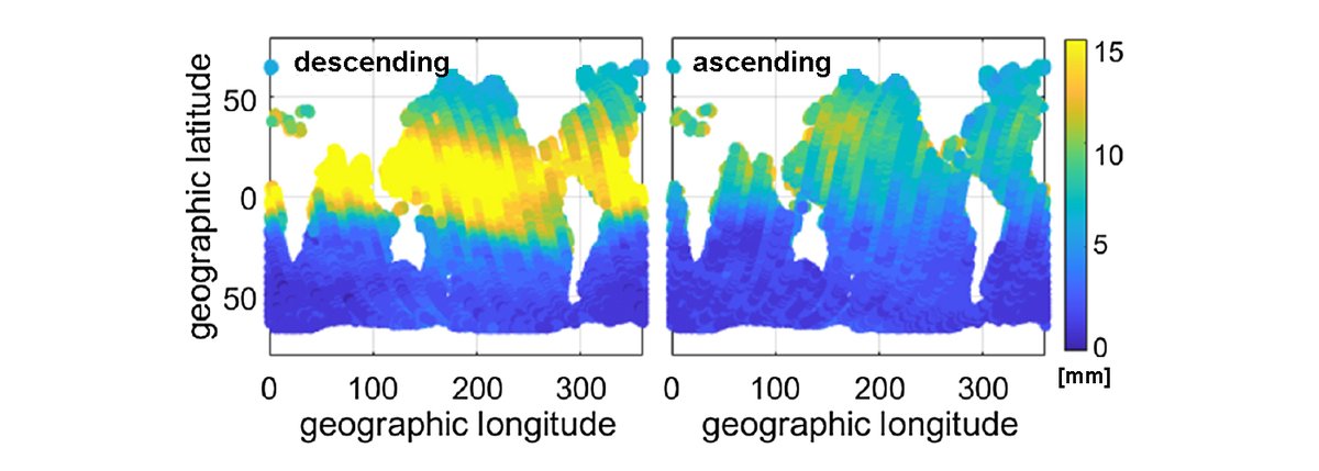
ALT Plasmaspheric range correction (in mm) computed from GNSS-based ionosphere maps by a constant scaling for the Jason-1 mission. Left: descending passes; right: ascending passes
A milestone is reached! For meanwhile 10,000 targets worldwide our DAHITI Database for Hydrological Time Series of Inland Waters provides free hydrological information like water level, surface area & volume change from satellite data. Explore it at dahiti.dgfi.tum.de#Lakes
River slopes observed by #ICESat2: New algorithm enables the use of lidar data for continuous monitoring of water surface slopes (WSS) on reach-scale. WSS is essential for estimating flow velocity & discharge, and relevant as an altimetry range correction: doi.org/10.1029/2022WR032842
In a study related to GlobalCDA, project members from DGFI-TUM recently estimated Long-Term Discharge for the Lower Mississippi River Using Satellite Altimetry and Remote Sensing Images. Read more on doi.org/10.3390/rs12172693
Project members from DGFI-TUM recently published a paper related to the GlobalCDA project estimating
Volume Variations of Small Inland Water Bodies from a Combination of Satellite Altimetry and Optical Imagery.
Take a look at mdpi.com/2072-4292/12/10/160…
American fury at news of a German submarine firing torpedo on US Navy ship Greer in mid-Atlantic. USA's debate over joining the war is heating up. Cartoonist Dr. Seuss's view:
Wenn ich mit #tex meinen simplen code in kompliziert aussehenden Formeln ausdrücke fühle ich mich immer so intelligent. Jetzt verstehe ich die #Mathematiker.