
Jun 10
🛰️📡🇺🇸 NASA’s Sentinel-6 just dropped high-res sea surface height data showing powerful Kelvin waves slamming into South America’s coast — classic precursor signature. Equatorial Pacific is lighting up.
As a retired USAF Imagery Intel Analyst (Predator vet), this screams developing El Niño, with models pointing toward a potential Super event by late 2026.
Warmer waters = disrupted Walker Circulation, flipped rainfall patterns, and amplified extremes on top of our warming baseline.
South America flooding risks, Southeast Asia drought/fire season, U.S. Southwest wetter winters, suppressed Atlantic hurricanes. Global ag and supply chains on notice.
Watch the Niño 3.4 index and stay frosty — early warning from space is intel we can actually use.
What impacts are you tracking in your AO?
#ElNiño #Sentinel6 #ClimateIntelligence #ImageryAnalysis @NASA @NOAA

ALT El Niño
125

May 29
ପ୍ରଶାନ୍ତ ମହାସାଗରରେ ଚିହ୍ନଟ ହେଲା ଏଲ ନିନୋର ପ୍ରାରମ୍ଭିକ ସଙ୍କେତ। ୧୦୦୦ କିଲୋମିଟର ଚଉଡ଼ା ଉଷ୍ଣ ଜଳ ତରଙ୍ଗ ବା କେଲଭିନ ୱେଭ ଚିହ୍ନଟ କଲା ନାସାର ସାଟେଲାଇଟ। ଆଗାମୀ ଦିନରେ ବିଶ୍ୱର ପାଣିପାଗରେ ଆସିପାରେ ବଡ଼ ପରିବର୍ତ୍ତନ।#ElNino #KelvinWave #NASA #Sentinel6 #ClimateChange #
3
27
1,741

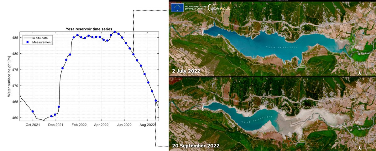
Roseires and Lake Tana: When Satellite Water Level Products Disagree, the Problem May Be the Data Processing Systems, Not the Water
Something important is happening right now in Blue Nile monitoring, especially around Roseires Reservoir and Lake Tana.
There is currently a discrepancy between major satellite altimetry products. One global database is not showing early April updates for some stations, while another operational system is already updating through early April 2026. That is not a trivial detail. It is an operational data issue.
The first system is DAHITI, the Database for Hydrological Time Series of Inland Waters. It is a long established multi mission altimetry product for lakes, rivers, and wetlands, producing water level time series from retracked altimeter waveforms using outlier filtering and Kalman filter based processing.
The second is Theia Hydroweb’s operational lake product, HYDROWEB_LAKES_OPE. It is designed for near operational monitoring and provides water level, extent, and in some cases volume, using the HySOPE processing chain with quality controls based on backscatter, or sigma0, behavior and reported standard deviations. Its coverage currently extends into early April 2026.
This matters because these systems do not always update on the same timeline. DAHITI can lag when the newest passes have not yet met retracking or acceptance thresholds. So for Roseires related monitoring or Lake Tana tracking, you may see no fresh DAHITI retracked points for early April while Hydroweb is already publishing new operational values.
That kind of mismatch can easily be misread. Someone may think the reservoir or lake is showing a new hydrological signal, when the real issue is processing delay, retracker behavior, or ingestion timing.
That is why this must be handled with disciplined quality control. In an operational workflow, any cross provider water level difference of more than a few centimeters over a short period should be examined carefully. Passes from Sentinel 3 and Sentinel 6 should only be ingested when per track quality metrics are acceptable, especially backscatter or sigma0 validity, standard deviation, and retracker compatibility. And when DAHITI has no new retracked pass for that period, that absence should be flagged as a data gap, not misread as proof that nothing changed. Missing data can bias comparison, trend interpretation, and even assimilation workflows.
So for anyone watching the Blue Nile through Roseires Reservoir and Lake Tana, think this: when respected altimetry products disagree in timing, do not force the data into a false story. First ask which system is delayed, which one is near operational, what quality filters were triggered, and whether you are seeing real hydrology or simply processing latency dressed up as hydrology.
#BlueNile #Roseires #LakeTana #SatelliteAltimetry #Hydrology #DAHITI #Hydroweb #HySOPE #Sentinel3 #Sentinel6 #RemoteSensing #WaterLevel #EarthObservation #DataQuality

1
2
9
573

heres a transcript, press ctrl f and save yourself some time
Dark Souls 2 released recently and being a big fan of the series I couldn't help but jump in straight away rather than
wait for the PC release I've been playing for a while now and hoping that the game would grow on me more than it did initially but unfortunately I found0:05
it to be a pretty disappointing experience before I go any further though I want to explain where I'm0:12
coming from I've been playing the Souls game since not long after the launch of demon souls from there I grew to love0:17
the game and love Dark Souls even more once it came out the important thing is I played all three games the same way0:23
the first time true I always played a night never summoned for any Co-op and never looked up a guide for anything0:28
until I completed my first playthrough after my first playthrough I would then go back in and explore the games further0:34
with different characters in other words I'm judging all three games from the same Baseline experience I also want to0:40
say before I start talking at length about why I found Dark Souls 2 disappointing that it's still a pretty good game I'm being totally genuine when0:45
I say I would much rather play Dark Souls 2 than most games that have released in the past few years but I also can't seem to overcome this feeling0:53
of disappointment M with all that said let's start at the beginning the first major problem with Dark Souls 2 happens0:59
less than a minute into the introduction rather than being booted directly into the character creation screen like the1:05
previous games this one Waits until after an opening sequence before asking you to make your character this means1:11
the character's identity has to be hidden by their clothing until that point but they do a really poor job of this since the character's build1:16
obviously looks male once you arrive at things betwix you can even take your clothes off and confirm it not only that1:22
but there's an utterly pointless as flashback sequence which also indicates the character is a guy as well you could1:28
maybe pass this off by saying it's not a flashback of the player character but in that case it has no reason to exist it1:34
feels tonally out of place in the soul series which has always left the player character's history up to players1:40
themselves and completely conflicts with any female characters normally I'd be the first person to argue that a game1:45
can benefit greatly from giving the main character a defined gender even if only because of the amount of hassle that can1:51
be saved from not having to implement interchangeable pronouns or voice dialogue story driven games usually1:56
benefit much more by focusing on other details so it's unreasonable to expect every game to cater to both sexes in2:02
this way but the souls games had been doing fine at this up until now in any game where I can choose a gender I2:08
always play as a guy but even so this introduction was so pointlessly botched that I couldn't help but think how2:14
alienated I'd feel if I wanted to play as a girl this whole thing feels like they went to the trouble of creating an2:19
FMV trailer and then had to find some way to retrofit it onto the game itself after choosing a character the old2:25
ladies then say you lose your souls all of them over and over2:31
again you can practically hear the developers laughing at your expense as she says this they're basically saying2:42
we made this game really hard that's what you wanted right now it's no secret that Mia Zaki the director of the2:48
previous two Souls games wasn't brought back as the director for Dark Souls 2 but his insight into the previous games2:54
can can still say a lot about this game in practically every interview he's ever taken since the release of demon souls2:59
Miyazaki has asked to comment on the difficulty of the souls games and the answer that he gives over and over again3:05
is that difficulty was never the point the games weren't designed to be challenging just for the sake of it it3:11
was a way to pull you into the world and the Peaks and dips and difficulty can be used to effectively set up a climactic3:16
moment like the fight with orstein and SM it feels to me like difficulty was a big focus in Dark Souls 2 which is a3:22
crucial misunder standing on the part of the new directors of this game probably helped along with some pushing from Namco who have enjoyed playing the3:29
difficulty card for marketing purposes since before the release of Dark Souls as soon as you get to Mula there's even3:35
a counter tracking the number of deaths you can also go online and see a full breakdown of the ways people have died3:41
the most obvious way this has been misunderstood however is with the boss fights in Dark Souls 2 I got the3:47
impression the developers were asking themselves how can we make this fight difficult whereas the question they should have asked is how can we make3:52
this fight interesting a good comparison is the Royal Rat Authority and CF the fight with the Royal Rat Authority is3:59
much more difficult but CIF is far more memorable difficulty doesn't necessarily equate to a good experience even in a4:05
Souls game one of the first images that pops into my mind when I think of Dark Souls is a giant proud looking wolf4:11
wielding an enormous sword while protecting the grave of his master the Royal Rat Authority on the other hand is4:17
a retread of the Sith fight with four random enemies which inflict toxin slapped in front of it to make it harder4:23
if you manage to kill the four Rats the fight is practically over but unless you're a pyromancer it's a crapshoot4:29
about whether you'll manage to get them all before the giant one mauls you to death similar problems extend to other4:34
boss fights which seem to follow the Mantra if you can't make it good make it difficult by adding more stuff in Demon4:39
Souls the maneaters were arguably the ultimate spike in difficulty you got partway through the boss fight and suddenly there was two of them it was a4:46
moment designed to induced panic in most players since they knew their odds of making it out alive just dropped significantly in total there was four4:52
bosses in Demon Souls which included multiple enemies the others being very mild in comparison to the maneaters in4:59
Dark Souls 1 there was six bosses with multiple enemies seven if we include the sanctuary Guardians in the DLC in Dark5:05
Souls 2 the number of bosses with multiple enemies jumps to 11 12 if we include dark lurker most of which feel5:11
as lazily designed as the Capper demon encounter rather than make the frey a fight Difficult by giving her a5:17
challenging move set the designers just Dro some random spiders into the battle instead the epitome of this lazy mindset5:23
is the belfrey gargoyles a copy pasted setup except this time there can be more of them active at once this all might5:29
have been fine except it doesn't play to the series strengths whatsoever the mechanics of the souls games are built5:35
for one-on-one engagements thanks to its slow attack animations which are uninterruptible once they start and a5:41
lock on camera which focuses heavily on a single foe take the prowling megas fight for example if you want to kill5:47
one of the crawling Undead littering this fight your eyes need to be taken off the casters at the back in order to5:53
lock on from there you'll have three enemies shooting you at once and since most actions aren't interruptable once5:58
they start it's extremely difficult to know when a safe time is to start an attack animation without having vision6:04
of the enemy the Twin Dragon Riders are another example of this you want to avoid attacks from both of them while6:09
periodically damaging one of them but in order to do so you need to lock onto one and position yourself in such a way so6:15
you can see the other this could have been mitigated by better audio cues on the bow as it's loaded and fired but6:20
this is seriously overshadowed by the music I found myself having to repetitively run up and down the arena6:26
so I could keep both of them on screen feeling like I was fighting the controls more than the bosses themselves even6:31
during engagements where the camera works well such as the trone Watcher Looking Glass Knight and Ruin Sentinel6:37
fights the gameplay suffers heavily from the multi- boss setup you need an extreme amount of patience to get6:42
through any of these bosses in a safe manner the only strategy here is to wait for both enemies to exhaust their entire6:48
combo at the same time before doing a single attack on one of them and then going back into defensive if you dare to6:53
attack any of these bosses with more than a single hit at a time or while one of them is still active then you'll usually be punished immediately the main6:59
challenge in most of these fights is not losing your cool and doing something risky before the end so really the7:06
reason half of these fights are any difficult at all is because they're so boring you want them to end slightly quicker by seeing if you can maybe get a7:11
second attack off before rolling away again the variety in bosses is severely lacking with far too many being7:18
oversized humanoid figures with giant weapons they even often have similar move sets with a slow overhead attack a7:25
gap closer and a two or three hit swiping combo attacks also lock on to an unnecessary degree far more than in7:31
previous installments where enemies usually had move sets with their own weaknesses and strengths when a boss7:37
goes to do an overhead attack it will usually track the player up until the very last moment before impact even if7:43
this means the boss has to spin around like they're standing on top of a record player I can only speak for myself but I7:48
was hoping to see less of this kind of stuff not more bosses should have move sets which don't rely on tracking the7:53
player in such a cheap simplistic way and it's notable that big bosses in Demon Souls and Dark Souls 1 usually7:59
lack this kind of lock on or only used it during part of the windup in order to compensate for their powerful moves this8:05
was one of the things that set the previous Souls games apart from other titles and gave the combat a better sense of fairness it was also less8:12
problematic in those games since the Boss Designs were more varied after my sixth fight with a giant armored enemy8:19
with a giant weapon and the same basic move set I was getting pretty bored regular enemy attacks due to successive8:24
amount of tracking as well even when it's completely unnecessary take the turtle armored enemies for instance8:30
despite their massive suit of armor they'll follow the player 360° on any of their attacks the sad thing is these8:36
enemies have a built-in counter measure for any player who Gets behind them so there's no excuse for them to be constantly facing the player the8:42
challenge here should have been to try staying to the side of the enemy without getting too close to the front of the back instead they just require the same8:48
tactics as every other enemy in the game it's not just bosses that suffer from the mentality that more enemies somehow8:55
makes the game play better the regular enemy placements fall into this trap as well there's far more groups in Dark9:01
Souls 2 which automatically aggro together in clumps forcing the player to fight against two or three difficult9:07
enemies at a time Dark Souls 1 had a lot of mobs as well but they were balanced around this idea mob enemies would have9:12
low Health lack a shield or do comparatively little damage sometimes all three large or heavily armored9:19
enemies in Dark Souls 1 were usually placed in positions where the player could fight them one-on-one even right9:25
up until the very last area because that's what meshed best with the core mechanics Dark Souls 2 just haphazardly9:30
places massive enemies all over the place dealing with multiple strong enemies like this comes across as a9:37
hassle rather than an interesting fight which encourages players to use cheap tactics instead of playing fair in most9:42
cases the AI is still easily abusable by backing off into a corridor and firing at range this occurs so much I'm left9:48
wondering whether the designers thought this made for a good gameplay scenario somehow as a Malle character you can pull back9:55
until the enemies start walking back to their starting point leaving only one of them to deal with and as a ranged10:01
character you can stand back and abuse the ai's inability to move into certain areas this gets taken to ridiculous10:06
Heights later in the game if you ask me King Vendrick should have just defended his kingdom by building more10:12
doorways in the previous Souls Games part of the challenge sometimes was getting back to a boss after failing to10:18
kill them if the level didn't open a shortcut or there wasn't a nearby bonfire you had to Traverse the level10:24
again and then make it to the boss in good enough condition to kill it this was one of the things that Drew people10:29
to the series in the first place because it was challenging but still very fair now look at this path to valal in Dark10:34
Souls 2 it's a single Corridor littered with no less than seven heavily armored enemies there's no sense of progress10:40
slowly making your way down a corridor by fighting the same enemy seven times so you're far more likely to just run10:46
through it the same goes for the hallway leading up to the Looking Glass Knight there's no point putting a bonfire next10:52
to a single Hall way with enemies most players are simply going to run past they might as well have just placed the10:58
fog door there and saved everyone to hassle there's similar setups for the Lost Sinner the ancient dragon and part11:03
of the run for The Executioner's Chariot this isn't level design it's tedious lazy and11:09
frustrating despite having a much more heavy-handed and long- winded introductory sequence the plot of Dark11:15
Souls 2 plays itself out far more poorly than in the first game I want to quickly make a distinction though there's a11:21
difference between plot and lore lore is the backstory of the world and all that kind of stuff but the plot is what's11:27
happening right now what the main character is doing why they're doing it and so on first I'm going to summarize11:32
the plot in Dark Souls last chance to turn back if you want to avoid spoilers the intro video to Dark Souls 111:37
establishes all the major players which will become important later on giving us an idea of what makes them special and11:44
what their role was in shaping the world the way it is when we start the game proper we're told about the curse of the11:50
undead and our character has been imprisoned for carrying the curse then after some indeterminate amount of11:55
time Oscar breaks the player out of their cell shortly after we find Oscar mortally wounded and he asks us to12:01
fulfill the prophecy of the undead by ringing the two bells of Awakening When we arrive in lordran that's our goal12:07
once the two bells are rung we have no idea what to do next but this awakens framp who says we need the Lord vessel12:13
to complete the prophecy after which he explains he's seeking a successor for gwin so we can link the fire linking the12:19
fire seems like a good idea so we probably want to go with that this carries us to the end of the game where we secede gwin there's more to it than12:25
that but that's the gist especially for a first time player the intro video to Dark Souls 2 shows the main character12:32
dropping into some kind of Whirlpool because the old lady tells us we're cursed and the only hope of a cure is to12:39
go to Drang Lake for some reason she actually says we'll have no idea why we're going to do any of the stuff we're12:44
about to do upon arrival we go to a shed and some more old ladies laugh at us then after arriving in medula the maiden12:49
in Green tells us to find the king it's not explained why we might want to do this but I suppose we can just imagine12:56
he has some kind of cure on a hunch that the King has a cure even though the entire kingdom is crawling with Undead13:01
we go and kill four powerful demons to open the Shrine of Winter this allows us to get to drag lightake castle where the13:07
queen tells us to find the king when we find him he's gone Hollow so then after some exploring we go and talk to a13:12
dragon for some reason and the dragon tells us to go into the memory of the Giants for some reason and this annoys the queen for some reason so we kill her13:18
and take the throne for some reason the pacing of Dark Souls 1 wasn't great after after the Lord vessel but it did a13:24
lot more with a lot less when it came to its plot its introductory video set up the world and the major players very13:30
efficiently I also think people underestimate how important Oscar is in Dark Souls he's the one who kicks off13:36
the events of the entire game personally I was never interested in the prophecy but I wanted to honor the dying request13:41
of the guy who freed me so it worked out either way this is all the plot of Souls game needs it seems to me that the new13:47
directors confuse the obtuse nature of the lore in Demon Souls and Dark Souls with the plot the story was never13:53
complex in the previous Souls games whereas the one in Dark Souls 2 was poorly presented and unnecessarily13:59
convoluted which left me without a strong sense of purpose for most of the experience even now replaying the game I14:04
have no idea why my character agrees to start wandering Drang Lake killing everything inside at the start C I wish14:10
I could say it was only the main storyline which was a step backwards but nearly everything involving the NPCs feels like a sharp downgrade from the14:16
first game in Dark Souls 1 players find and rescue more and more NPCs which head14:23
back to the shrine for arrest those NPCs are often useful to the player in some way but the genius of it is they also14:28
often disappear from the shrine at some point to each character in Dark Souls 1 feels like they have some kind of goal14:34
in the world and the fact that they move from the shrine brings them to life it feels like their usefulness as a vendor14:41
to the player is secondary to their own goals you're not the center of the universe and Dark Souls one at all each14:46
character has their own little story they go through as the game progresses this gives them all an air of believability and provides a satis fing14:52
sense of closure even if that closure usually results in them going Hollow in Dark Souls 2 once an NPC arrives at14:59
medula they remain in the exact same location for the entirety of the game and nothing of note happens to any of15:06
them during the entire playr the worst example is the blacksmith's daughter who sits on a rock just yards from her15:11
father and mentions he looks a little like her dad talking to the blacksmith reveals he's happy she's come home and15:17
yet no matter how much time elapses or how much you talk to either of them nothing ever gives you the impression that the daughter has ever bothered to15:23
say one word to the blacksmith working just a little to her right and vice versa the most original thing the game15:29
does with any of its NPCs has turned the story of patches and low Trek on its head by making it more ambiguous and15:35
pitting them against one another instead of the player this had me intrigued to begin with but ultimately ends up15:41
disappointing too since they're busy with each other it's hard to feel involved and neither of them does anything interesting with you until the15:47
end of their story I feel like this could have been great if the other NPCs had been able to compensate for this15:52
lack of interaction which was present in the previous games in fact I'm happy they didn't retread those patches and15:58
low track stories for the third time but the replacement story isn't quite up to the task at least this was quite16:03
original though which is more than I can say for most of the other NPCs especially crestfall and Warrior II I16:09
think from soft earned themselves some leeway since they were forced to switch from the world of demon souls to Dark Souls it seemed natural they might want16:15
to carry a few things over that's why I'm willing to overlook the appearance of patches and the crest Fallen warrior16:22
in Dark Souls 1 as well as the maiden in green and dark souls 2 The Crest Fallen Warrior has already existed in this16:27
universe though so seeing another character fulfill the same role with the same voice actor is really jarring it16:33
really hurt my suspension of disbelief when all I could think about while talking to him was how coincidental it was to have the exact same character16:39
appearing again thousands of years later for no reason the worlds of demon souls and Dark Souls were brilliantly realized16:45
because they felt internally consistent you have to suspend your disbelief about magic and all that but once you do the16:52
world behaves in sensical ways I'd credit this as part of the reason why Demon Souls became a cult hit in the16:58
first place it does an amazing job of pulling you into its world when I played the souls games I walked around17:04
cautiously taking in my surroundings and when presented with a situation where I had to make a choice I would usually try17:09
to make the one that would realistically pay off this wasn't solely because of the punishing difficulty of those games17:15
it was because the world made sense felt fair and was totally engrossing dark souls 2 simply doesn't have the same17:21
attention to detail as the previous games in this regard the world doesn't fit together either logically or17:27
thematically in Harvest Valley you can get a clear view of Earth and Peak and see the surrounding area after beating17:33
the Earth and Peak boss you then get in an elevator and go straight up about 15 more floors arriving at Iron Keep17:39
there's no hint of Iron Keep whatsoever from the outside of Earth and Peak from Harvest Valley the sky is overcast but17:45
an iron keep it has a red glow and the surrounding area is suddenly an enormous Wasteland of lava similar transitions17:51
exist at elsewhere going from the Tower of flame down to No Man's Warf makes no sense as this places the warf somewhere17:58
below sea level going to the boss in Alia's keep reveals the landscape to be far below but in reality the player18:04
should be more or less at the same altitude as Mula here since they've only walked up a few stairs even worse then18:10
transitioning to the dragon area reveals an obviously impossible set of outcrops in the sky which weren't visible just18:16
moments before there's a host of smaller issues as well such as the Tower of flame as seen from Mula which is way out18:22
of position position as a result the feel of Dark Souls 2 suffers heavily compared to the other games which felt18:28
much more consistent in their geography even worse than any of this is the Shrine of Winter which makes sense18:33
physically but not logically the player is expected to kill the four old ones or amass a million Souls before this will18:39
open and all it does is circumvent a pile of rubble a small pile of rubble blocks the way in the forest so rather18:45
and climb over it the character kills four of the most powerful beings in existence I understand why they wanted18:52
Drang Lake Castle gated off until later but this ridiculously poor level design shattered my suspension of disbelief so18:58
hard it never recovered it might have died in Alias keep anyway where a bunch of creatures sit around in cages they're19:04
easily capable of demolishing there were plenty of other weird grating decisions made in other areas too like bonfires19:10
which spawn you in range of enemies especially problematic since the character starts out vulnerable when they're teleported back after dying if19:17
you die to the last Center then decide to take a break when the loading screen comes up you'll be killed by The Archers19:24
at the bonfire over and over again losing all your souls in the process just across the bridge from there they19:29
also made the genius decision to place an important vendor in a room with five exploding enemies there's also the19:35
bonfire at Iron Keep which forces your character to go through belfa because there's a small wall in the way it's19:41
obvious that the level designers didn't have the same priorities when working on Dark Souls 2 I'd imagine the decision to19:47
allow warping right from the start of the game was made very early on in development since every level is essentially a long tunnel leading to a19:53
dead end I've seen some people compare this to the level
2
2
743

17 Nov 2025
El satélite climático Sentinel-6B ya está en órbita
hispaviacion.es/el-satelite-…
@AirbusSpace @ESA_EO @NASAJPL @CopernicusEU @EUMETSAT #SpaceMatters #SeeingTheSeas #Sentinel6
2
88

17 Nov 2025
A second Sentinel-6 ride on Falcon 9 really shows how routine SpaceX has made precision Earth-monitoring missions.
2020 was just the start—this sequel matters even more.
#SpaceX #Falcon9 #Sentinel6
2
109

15 Nov 2025
📢#Sentinel6B is launching soon! Why does it matter for #CopernicusMarine?
#Sentinel6 is the #Copernicus🛰️🇪🇺 mission dedicated to sea surface level monitoring & its observations feed directly into our products🌊
🔽#Dataviz showing sea level trends (1999–2024) from satellite observations

1
2
6
335
14 Nov 2025
#ICYMI
Yesterday's press briefing, hosted by @esa on the upcoming #Sentinel6B 🛰️🇪🇺 launch 🚀 highlighted the key role altimeter observations play in #CopernicusMarine ocean products
#Sentinel6 satellites are essential for measuring sea level rise, supporting climate adaptation efforts
1
1
5
302

23 Sep 2025
🌊🌊 Utilizing the #Sentinel6 Michael Freilich Equivalent Number of Looks for #Sea State #Applications
✍️ Lisa Recchia et al.
🔗 brnw.ch/21wW1bW

3
337

25 Jul 2025
El guardián del océano listo para despegar: el segundo satélite Sentinel-6 de Copernicus se dirige a su base de lanzamiento
Más información en: aeroermo.com/home/el-guardia…
#AeroErmo #AirbusSpace #Sentinel6 #Satelite #Copernicus #SpaceMatters
@AirbusSpace
2
74

24 Jul 2025
Airbus envía el segundo Sentinel-6 para su lanzamiento en noviembre actualidadaeroespacial.com/a…
@Airbus #Sentinel6
1
3
137

23 Jul 2025
🛰️ Le deuxième satellite Copernicus #Sentinel6 est en route pour le site de lancement de Vandenberg en Californie. Il fournira des données ultra-précises sur la topographie de la surface des océans.
Décollage sur Falcon 9 en novembre
📷 Airbus Space


1
12
567

24 Apr 2025
🌊🌊 Uncertainty in #Sea #State Observations from #Satellite #Altimeters and #Buoys during the #Jason3/#Sentinel6 MF Tandem Experiment
✍️ Ben W. Timmermans et al.
🔗 brnw.ch/21wSbXD
3
293
22 Mar 2025
🤚🤚 Optimal Configuration of Omega-Kappa FF- #SAR Processing for Specular and Non-Specular #Targets in #Altimetric Data: The #Sentinel6 Michael Freilich Study Case
✍️ Samira Amraoui et al.
🔗 brnw.ch/21wRvuL
2
398
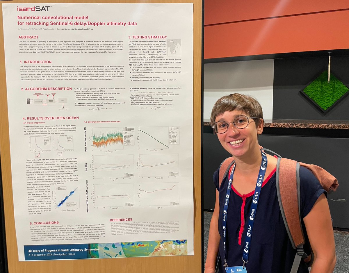
At #30YPRA Symposium, we presented a numerical convolutional model for #Sentinel6 #altimetry data that is able to improve the precision of significant waveheight estimates 🌊 and correct anomalies in global mean #sea level drift🛰️📈
More info 🔗isardsat.cat/project/s6-pose…
5
157
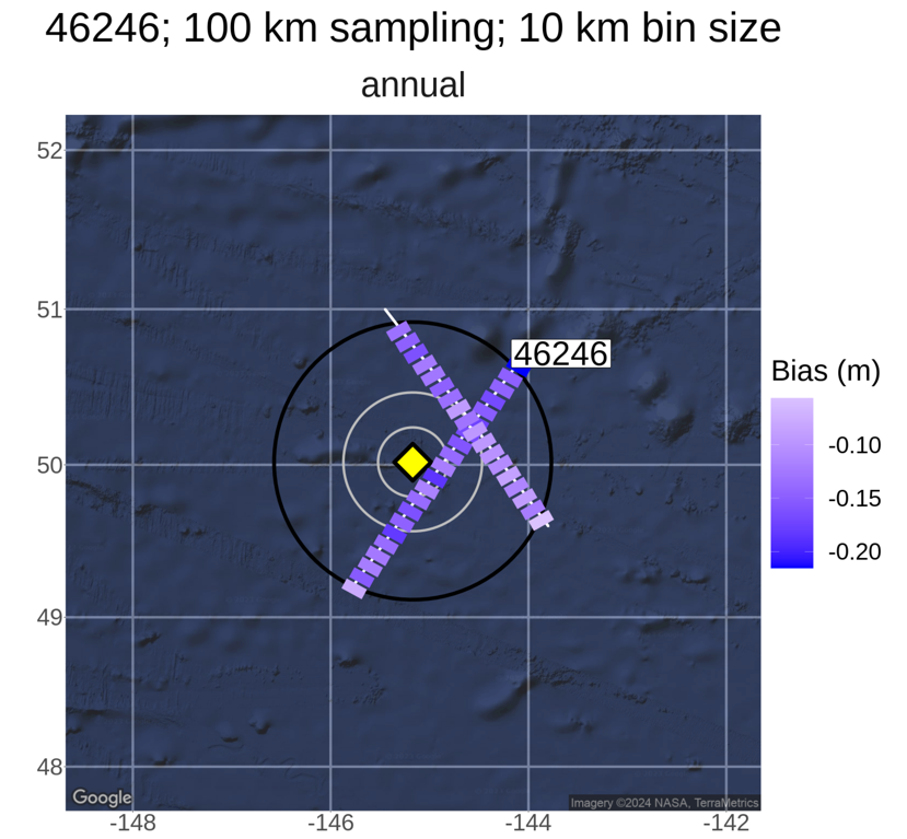
📡From #ERS1 to #Sentinel6, altimeter #satellite missions use ground transponders to calibrate and validate their data.
🌐In the last 30 years, significant advancements have allowed to consolidate a strong calibration and validation network.
We presented them at #30YPRA 👇

1
223
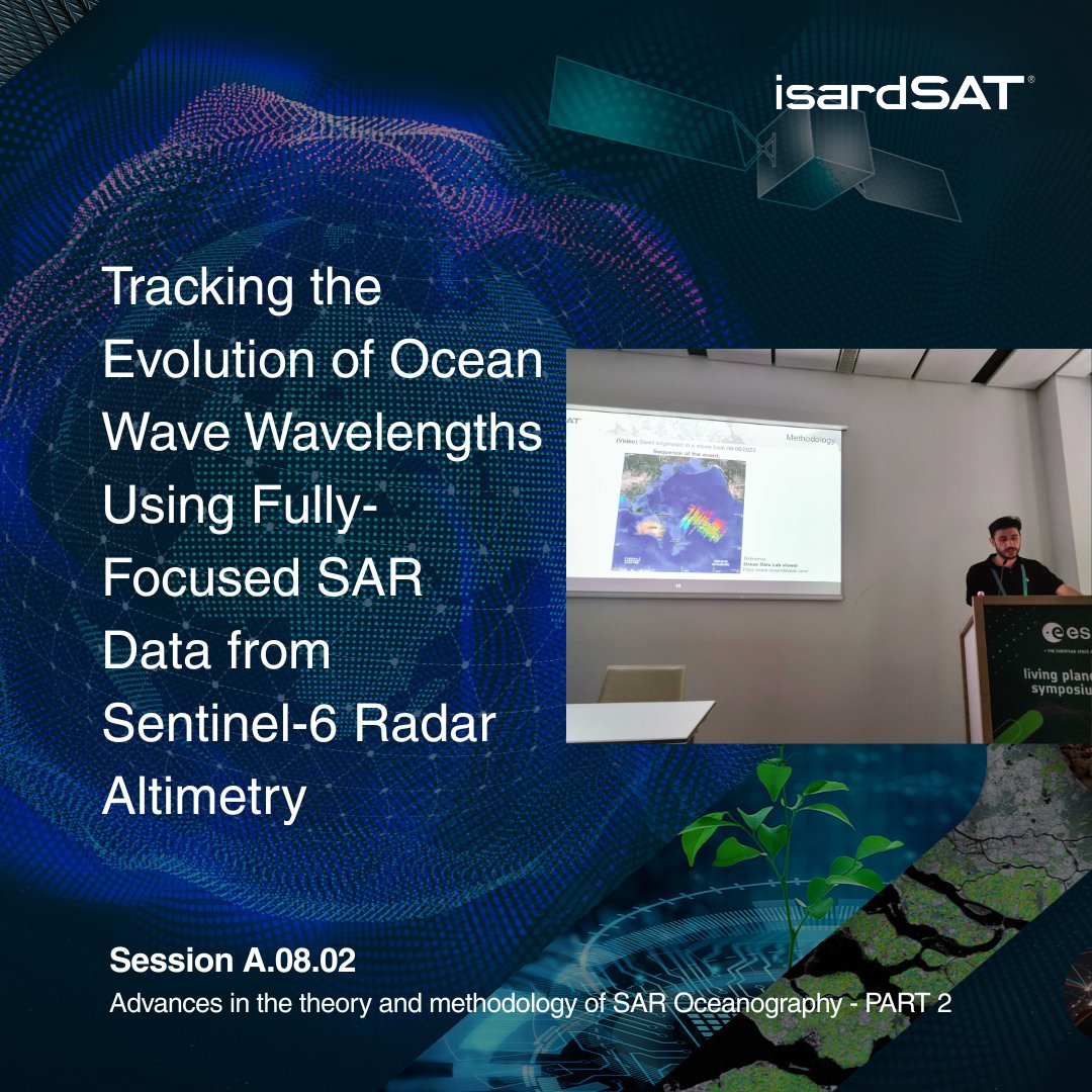
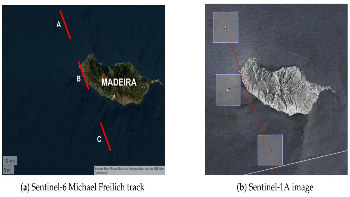
Fully-Focussed SAR #FFSAR altimetry has a great potential to monitor the #water level of small and medium inland water bodies.
At #30YPRA Symposium, we presented a methodology to retrieve water level from #Sentinel6 measurements over three targets in the Ebre river basin.

1
3
338
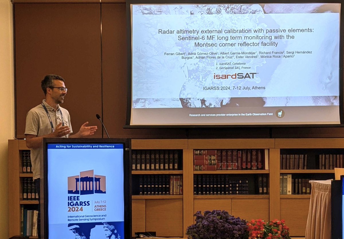
Last week, at #IGARSS2024, we presented how our corner reflector at #Montsec Observatory #OdM can calibrate #Sentinel6's altimeter to ensure its good work in retrieving key climatic variables 🌊
More info isardsat.cat/news/corner2
@IEEC_space @IEEE_GRSS @igarss
2
10
379
📆Next week we will be at #IGARSS2024 congress in #Athens to present our work in the external calibration of #Sentinel6's altimeter, and our #SAR shoreline processor 🛰️
See you there!
@IEEE_GRSS @igarss

3
7
470