
Senior research fellow for China & nat sec @Heritage. Pod host: Nation States with Yates @iheartradio. Former WH deputy national security advisor to the VP.
Joined April 2011
- Tweets 6,570
- Following 4,512
- Followers 35,841
- Likes 86,554
229 Photos and videos


Pinned Tweet

Jun 5
My sincere thanks to @HouseForeignGOP for inviting me to address this topic of great policy and personal importance.

“In October of 2023, our family joined the growing circle of American families devastated by fentanyl.”
Listen to @Heritage’s @SteveYates share his personal story of how the fentanyl crisis, fueled by China, ended up costing his own daughter’s life:
19
33
88
6,580
Steve Yates (葉望輝) retweeted

While KMT chair Cheng Li-wun is touring the US, her deputy is in China, speaking at a united front event about the need to make Taiwan China again

Kuomintang (KMT) Vice Chairman Chang Jung‑kung's (張榮恭) argument at a forum in China that shared heritage be used to boost cross-Taiwan Strait ties has been criticized by the Mainland Affairs Council (MAC) for echoing Beijing's narrative. focustaiwan.tw/politics/2026…
6
23
68
5,565
Steve Yates (葉望輝) retweeted

“Xi knows that a robust Taiwanese defence industry that can produce the drones and other items that it needs at scale would significantly increase the difficulty of an invasion.” @heguisen
Drones hover at centre of Taiwan’s defence debate - @NikkeiAsia
asia.nikkei.com/opinion/dron…
12
20
59
3,573
Steve Yates (葉望輝) retweeted

Jun 13
China officially declared the waters surrounding Taiwan, including the Taiwan Strait, as its "near-shore waters" or "coastal waters" (近海) for the first time on 11 June 2026.
The Chinese Communist Party is setting up the (internally) legal premise for blockading Taiwan.
6
9
24
11,057
Steve Yates (葉望輝) retweeted

We are in a race against China for the best AI technology in the world and we must win. Right now, we have the best semiconductors in the world and China is doing everything it can to buy or steal them. Chairman @RepMoolenaar's SCALE Act would create clear standards for when and how export controls on semiconductor restrictions should apply. ijr.com/article/demystifying…
17
42
123
5,561
Steve Yates (葉望輝) retweeted

Jun 13
This clip of Charles Payne during Obama's second term is really incredible. Well done Charles.
In 2010 Obama put the federal government directly in charge of lending money to students. Eliminating private lending made the loans much easier to get, but they were not less expensive.
Before Obama took office, outstanding student debt was less than $100 billion. By 2015, outstanding student debt was approximately $800 billion and almost a third of the borrowers were in default. Of course the price of college continued to soar the entire time.
This is the best part. Payne predicted that someday the politicians would be promising to forgive student debt as a way to buy votes. He was spot on.
There are people like Ro Khanna on this site right now arguing that Elon Musk should be paying down the student debt when it's a problem that politicians created.
413
9,437
25,165
492,606
Jun 12
Great to join @BuckSexton today on the @clayandbuck show. Covered Iran, the geostrategic game changer that @SpaceX is for the US, and of course Terminator vs The Matrix. Continue the convo at Nation States with Yates! clayandbuck.com/steve-yates-…
1
12
36
11,555
Steve Yates (葉望輝) retweeted

.@SteveYates to @BuckSexton on Iran: "We've sort of had on repeat these cycles of a deal as imminent and then it's not, not surprisingly by the remnants of the regime."
3
5
29
5,153
Steve Yates (葉望輝) retweeted
.@BuckSexton asks @SteveYates to choose between Terminator and The Matrix: "It's not a tough call for me. I'm a Terminator generation person."
1
3
19
2,545
Steve Yates (葉望輝) retweeted

Jun 12
The only reason that China claims the James Shoal - an underwater feature off the coast of Borneo - as the 'southernmost point of Chinese territory' is because of a translation mistake in 1935 and some bad map-making. Let's all laugh at China in sticking with this idiocy...
Jun 11

The Silent Takeover: How China is Quietly Rewriting the Borders Off Sarawak’s Coast
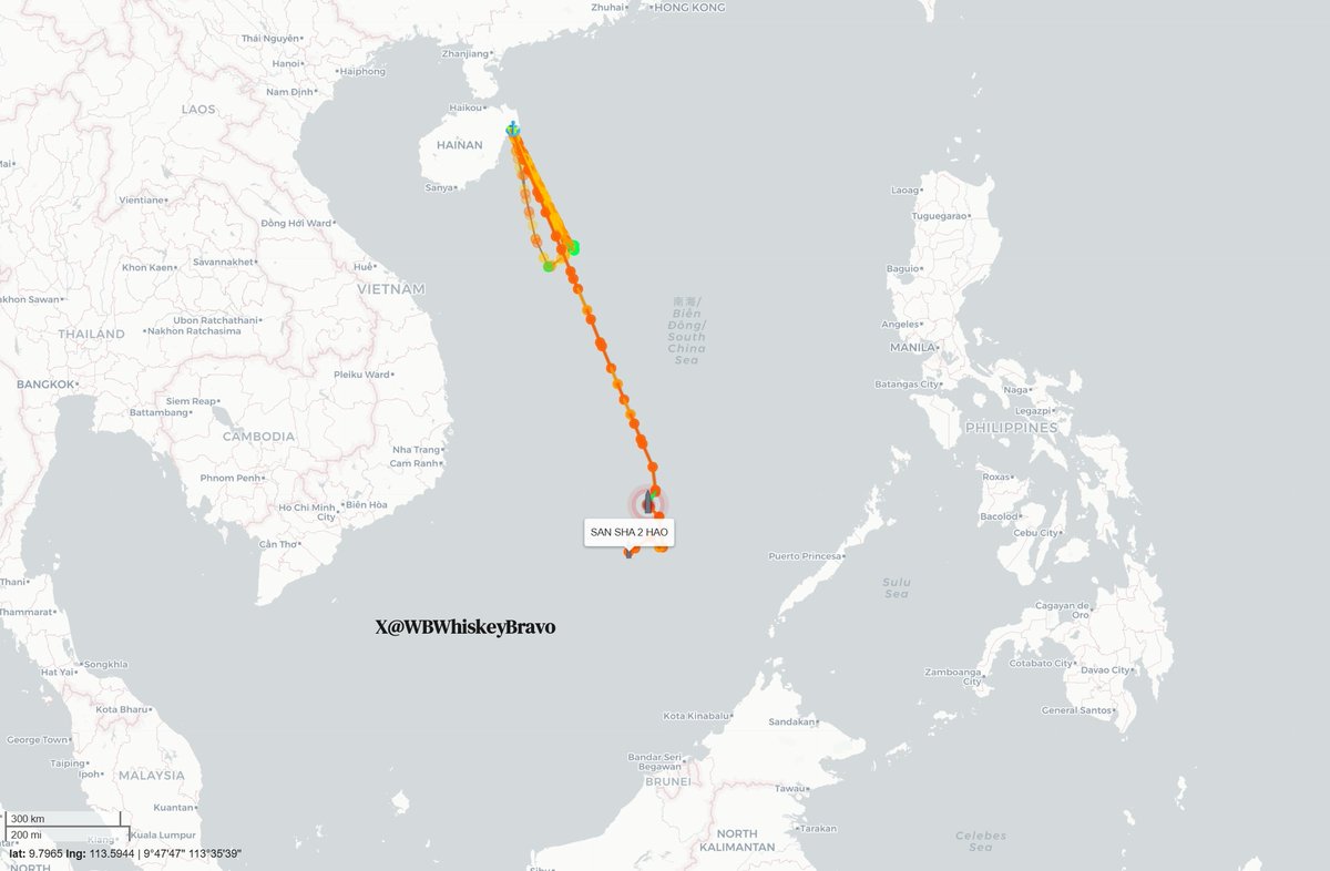
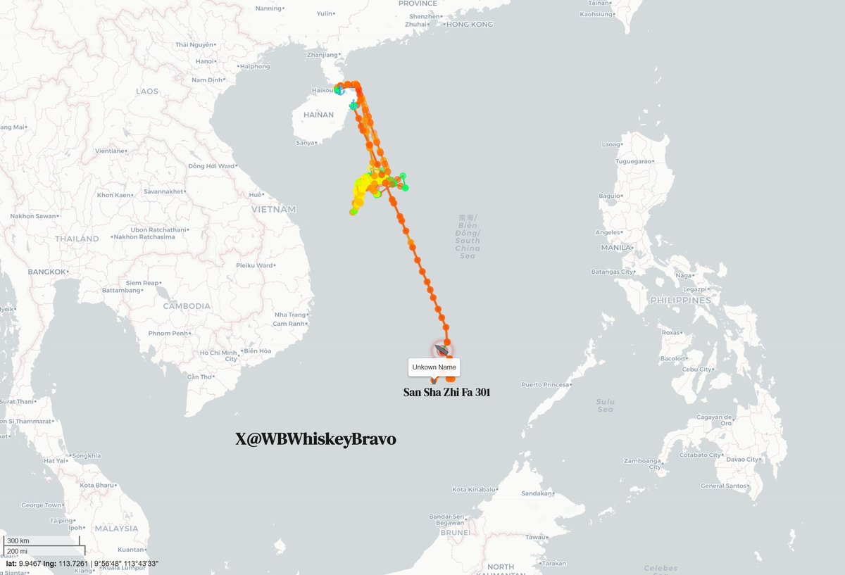
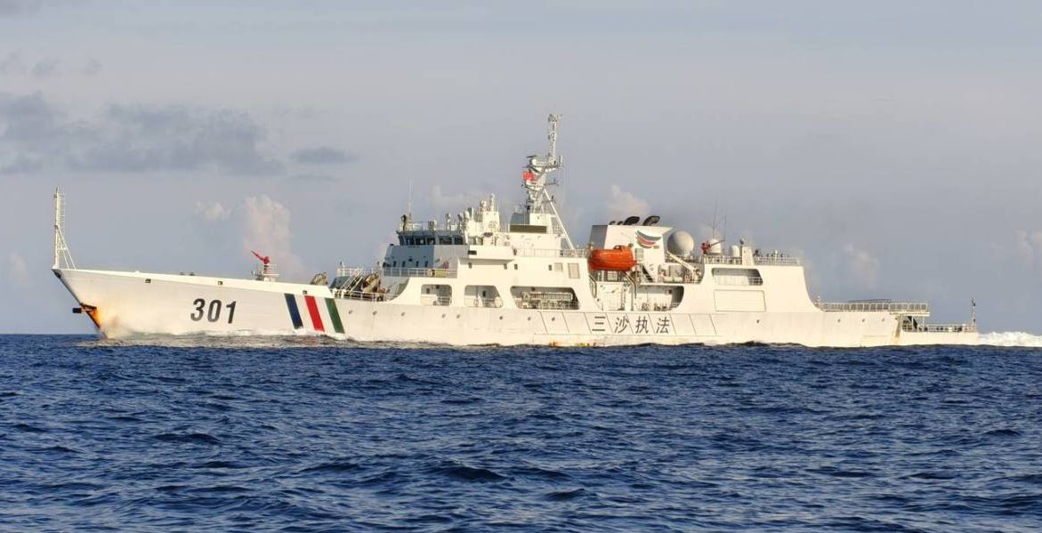
While most of us go about our daily lives, a quiet but deeply troubling game of chess is playing out just off the coast of Sarawak, where fresh ship-tracking data reveals that China’s massive 8,000-ton supply ship, the Sansha 2 Hao, along with its armed escort cutter, the San Sha Zhi Fa 301, has packed up and left Hainan. This fleet is steaming directly south toward Beting Serupai (James Shoal / Seahorse Breakers), a completely submerged reef sitting just 45 nautical miles—about 80 kilometers—northwest of Bintulu, placing it squarely in Sarawak’s backyard. This voyage fits perfectly into Beijing's broader grey-zone tactics, which are designed to aggressively change realities on the water while staying just below the threshold of open military conflict. To enforce its sweeping nine-dash line without triggering an international military outcry, China masterfully relies on "white hull"—coast guard and municipal vessels—instead of navy warships, allowing them to bully local maritime zones under the guise of routine domestic and administrative patrols.
The reason Chinese delegates and municipal fleets execute this voyage on a strict, annual basis comes down to a calculated symbolic ritual designed to manufacture legal and historical "evidence" of ownership. Because Beijing historically and geographically defines Beting Serupai (Zengmu Ansha) as the absolute southernmost point of Chinese national territory, it holds massive nationalistic and political significance. Since the feature is completely submerged about 22 meters underwater, China cannot build an artificial military island on it; instead, they send annual delegations on these white hulls to conduct "sovereignty ceremonies" above the reef. In past rituals, Chinese naval personnel and officials have literally dropped sovereignty steles (stone markers) into the water and stood on the decks to swear collective oaths of allegiance to defend the motherland's outer limits. By sending the Sansha city fleet down every single year, Beijing is attempting to satisfy the international legal criteria of "continuous and effective administration." They are intentionally creating an annual paper trail that falsely claims a local Chinese city has been successfully governing a piece of the seabed just 80 kilometers from Bintulu.
This annual municipal voyage is just the crowning piece of a massive, multi-tiered machinery that builds upon the homework done by older research ships like the Nan Feng and Zhong Shan Da Xue, which originally gathered resource intelligence in the Malaysian Maritime Zone (MMZ). Today, that legacy is carried forward by modern high-tech spies like the XIANG YANG HONG 33, YUE ZHAN YU ZHI 20026, and 20027, which were caught on satellite imagery on June 6 tightly bunched together at Terumbu Laya (Dallas Reef), updating underwater maps under the protective shield of armed white hulls like CCG 5302, 5403, 5309, and 5901. By dropping the Sansha municipal fleet directly alongside this ongoing scientific and military grid, Beijing is essentially using the annual trip to lock down East Malaysia’s richest economic zones, posing a direct threat to Sarawak’s multi-billion dollar offshore oil and gas fields. Yet, while neighbors like the Philippines push back through "assertive transparency" by openly exposing these incursions, Putrajaya has stuck to its strict playbook of "quiet diplomacy," preferring behind-the-scenes talks to avoid public friction. This heavy silence risks being misread by Beijing as "tacit acquiescence," giving them a path of least resistance to slowly turn a fictional map into a permanent reality. Furthermore, because national security is tightly controlled by the federal government, this quiet approach leaves the local Sarawak state leadership dangerously in the dark about a creeping grey-zone threat operating just a stone's throw away from its vital economic lifelines and maritime sovereignty.

9
33
64
9,148
Jun 12
For those interested in a long form discussion of a topic you often hear tossed around in the news, check out this episode of @zerohedge Debates. youtube.com/watch?v=Nh8tzWd2…
2
6
428
Jun 12
Great to join @FoxFriendsFirst early yesterday. As with all things Iran, the pendulum has swung a few times since, but the core elements of the conversation remain in play. foxnews.com/video/6398144018…
7
11
615
Steve Yates (葉望輝) retweeted

Jun 10
A CIA whistleblower recently testified that a willingness to "make excuses for China" is "pervasive" in the intel community, where a neoliberal worldview that favors unfettered free trade and scientific cooperation dominates.
For example, the National Academy of Sciences (which has done clandestine work since the earliest days of the U.S. biological weapons program) works with Chinese scientists without counterintelligence checks.
CIA Director John Ratcliffe says he is righting the ship.
Jun 10

Whistleblowers and declassified documents have revealed a pattern of the CIA and FBI soft-pedaling findings that could rattle China, raising questions about whether President Trump has the best information about America’s chief geopolitical rival at a high-stakes moment for U.S.-China relations.

32
211
666
80,740
Steve Yates (葉望輝) retweeted

Jun 12
JUST IN: Philippine defense chief vows to fight China’s “wickedness” after Beijing sanctions him.
74
94
814
69,648
Jun 12
Great to join Doug Bandow on ZeroHedge Debates. The question: Should the US commit to defend Taiwan against possible China attack?

5
10
22
1,384
Steve Yates (葉望輝) retweeted

The United States reaffirmed its commitment to the defense of Japan, using the full range of U.S. defense capabilities, including nuclear. Japan reaffirmed its support to U.S. forces and operations that maintain peace, and this support contributes to deterrence by denial.
Read more: state.gov/releases/office-of…
75
309
834
130,895


Jun 11
Great back and forth in this morning's @SquawkCNBC conversation about the state of the Iran conflict and necessary next steps. cnbc.com/video/2026/06/11/de…
12
21
2,316
Steve Yates (葉望輝) retweeted
Jun 11
Based on four in-depth case studies from Southeast Asia - Philippines, Malaysia, Thailand and Indonesia - this report finds substantial links between China’s united front system and criminal elements. The Chinese party-state and geocriminality... globalinitiative.net/analysi…
4
50
118
16,491
Steve Yates (葉望輝) retweeted

Jun 10
20 years ago, An Inconvenient Truth put climate change at the center of global debate, shaping politics, influencing leaders, and inspiring a generation of activists.
Two decades later, we can assess not just its impact, but its accuracy. Many of the film’s most alarming predictions did not materialize, while many of the policies it inspired have proven costly and ineffective.
The lesson? Panic is a poor guide for public policy. Focusing on innovation, adaptation, and economic development can do far more to help both people and the climate—at a fraction of the cost.
financialpost.com/opinion/bj…
486
3,161
10,840
328,164