
Meteorologist@ABC
Joined May 2012
- Tweets 1,477
- Following 108
- Followers 1,951
- Likes 973
461 Photos and videos
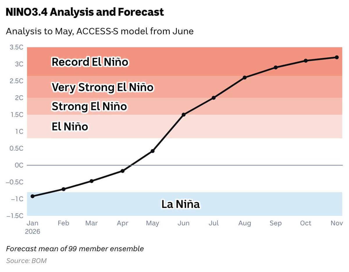


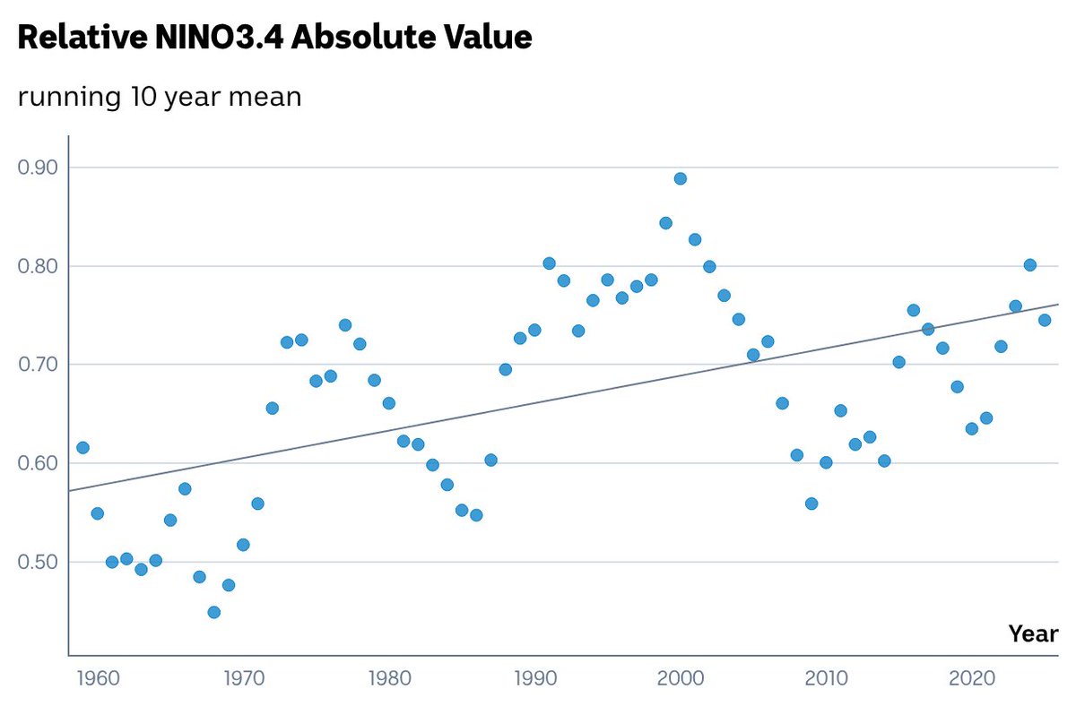

Record #ElNiño predicted by latest update of ACCESS-S model. The ensemble mean of Relative Niño3.4 is forecast to exceed 3C, comfortably above the current record of 2.65C from November 1902 (ERSST v5)
1
1
3
414
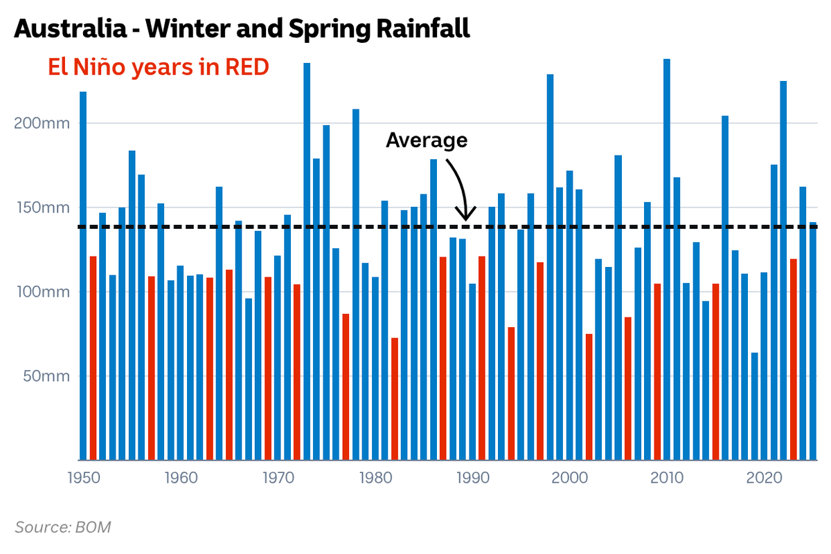
Here's an illuminating way to view #ElNiño's impact on Australia's winter-spring rain. Not one single El Niño since 1950 has been wetter than average on a national scale. Locally though there is a much greater variability.
5
3
16
75,572
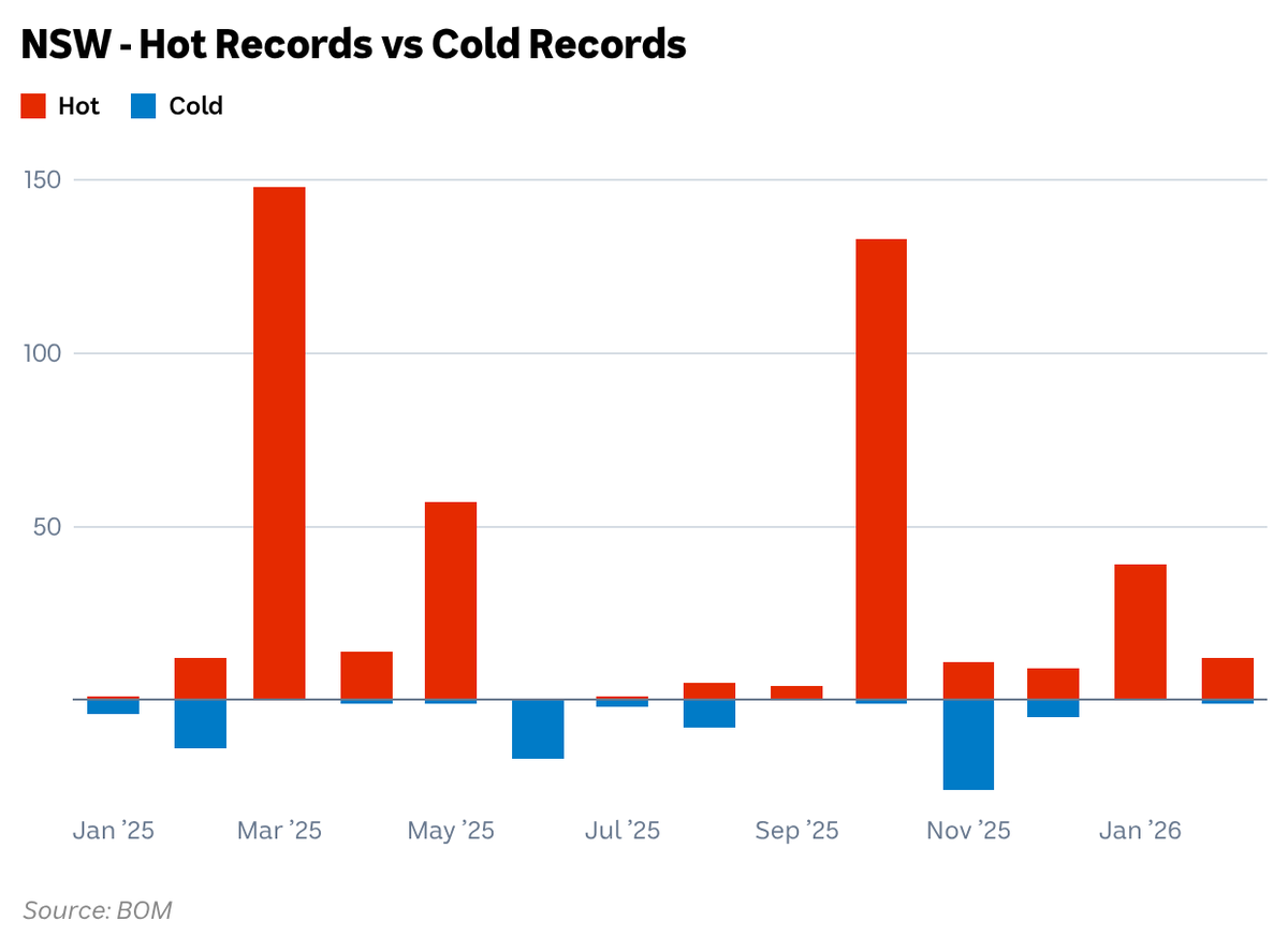
Graph I showed on ABC News last night to put last week's record cold March temperatures in perspective. From January 2025 to February 2026, 446 hot records were set in NSW, compared to 80 cold records.
1
4
12
450
#CycloneNarelle's near 2 week journey is almost over. It will become the first Australian cyclone in 21 years to make landfalls in QLD, the NT and WA. Please excuse the slight error in category over the Top End and Kimberley.
15
117
512
74,952
Mesovortex is visible within the eye of #CycloneNarelle. Only the strongest storms exhibit this feature. Image from the JMA target satellite. #Queensland #Narelle
13
20
1,715
#CycloneNarelle could be the first in 21 years to make 3 separate landfalls. #Narelle #Cyclone
abc.net.au/news/2026-03-18/c…
1
22
59
6,012
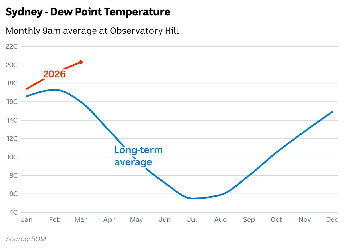
The humidity the past few weeks has been oppressive in #Sydney. And I have the proof ... but using dew point which is a far more direct and accurate measure of atmospheric moisture than RH%.
24
29
263
25,034
If El Niño develops this year as predicted by modelling (which are least accurate in Jan-Feb) lets see if we can finally avoid the misinformation about a dry summer.
abc.net.au/news/2026-02-12/p…
1
1
9
511

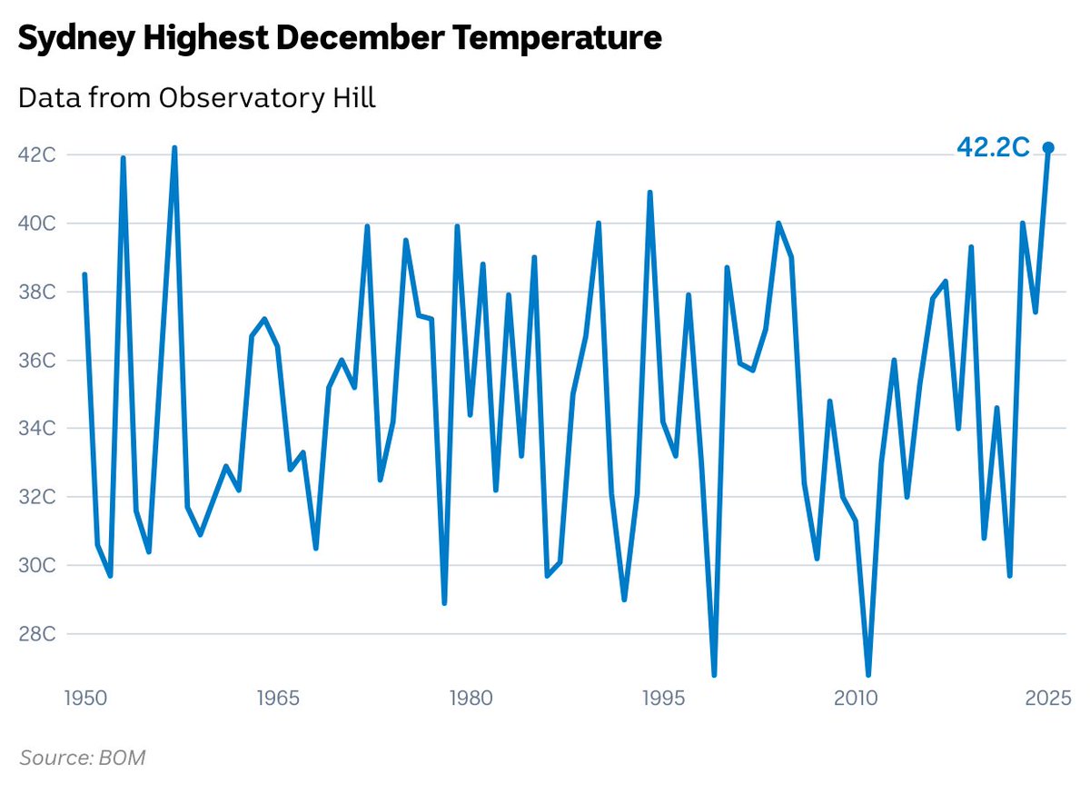
19 Dec 2025
#Sydney has now recorded its equal highest December maximum. Tied with 42.2C from 1957
3
1
10
600
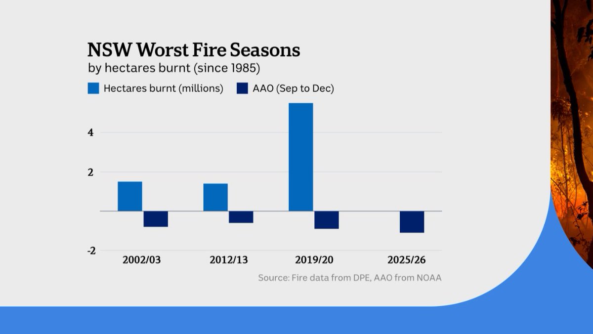
9 Dec 2025
Graph I showed on ABC news last night. The 3 worst fire seasons since 1985 for NSW in terms of hectares burnt all have a negative Antarctic Oscillation from Sep to Dec (proxy from SAM). Some negative SAM years though, like 2000, aren't bad fire seasons - so there is hope.
3
3
9
964
27 Nov 2025
There is a global misconception the Gulf Stream is the main reason western Europe has mild winters. I would argue the key is the presence of any major body of water to the west, regardless of currents. Eg Vancouver is only slightly cooler than London at a similar latitude.
1
4
446
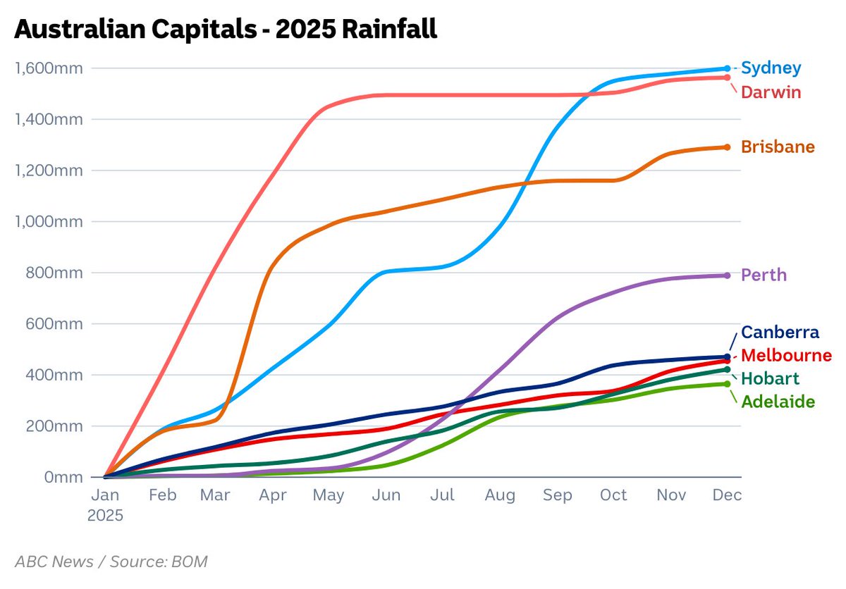
5 Nov 2025
October was dry but #Sydney is still winning the rain race this year - about 4 times Melbourne, Adelaide, Canberra and Hobart.
8
3
19
2,044
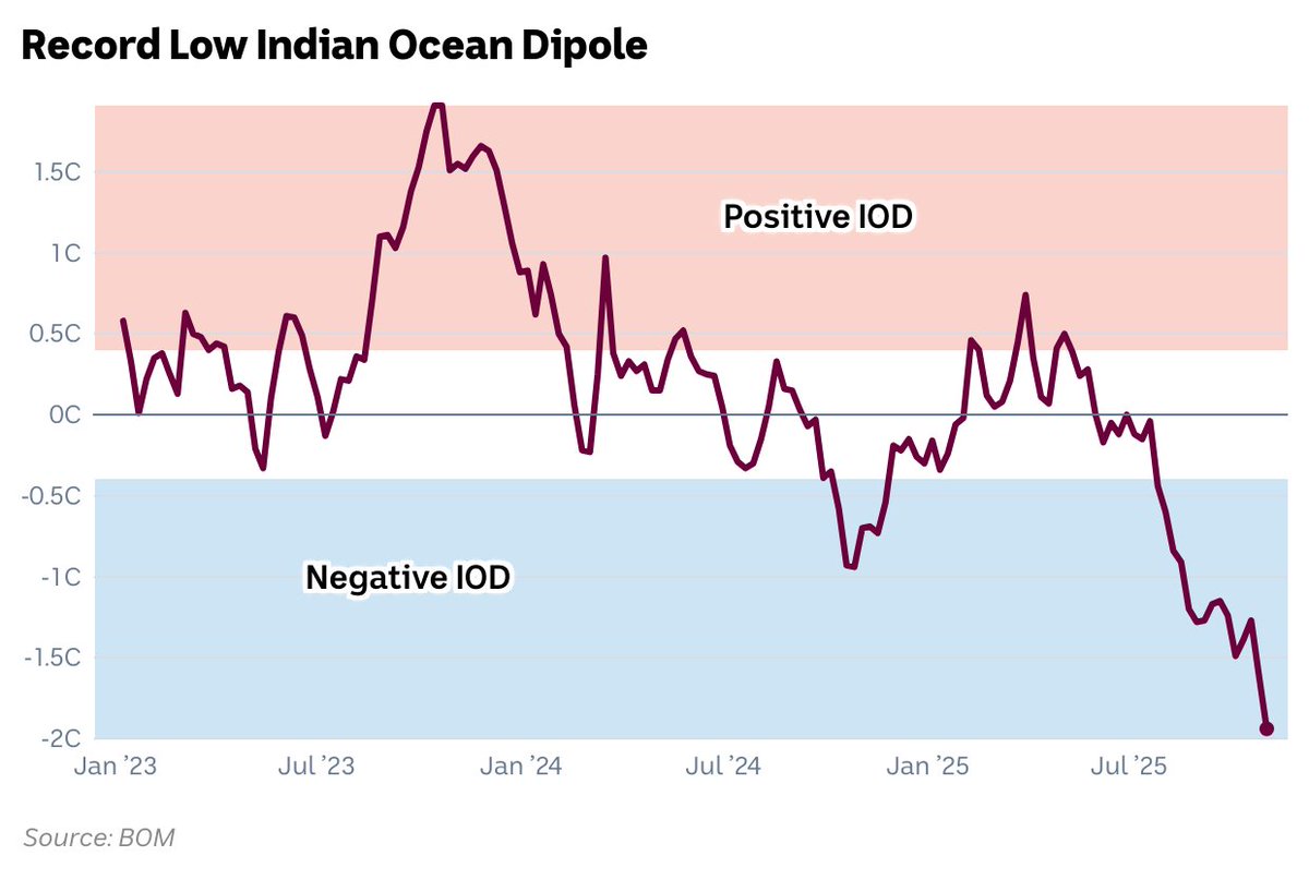
4 Nov 2025
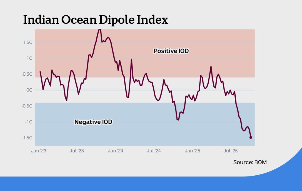
The Indian Ocean Dipole index has dropped to another record. The latest weekly measurement of -1.94 is the lowest in the BOM's database extending back to 2008. Earlier monthly calculations suggest its the lowest since at least 1996.
4
9
52
54,213
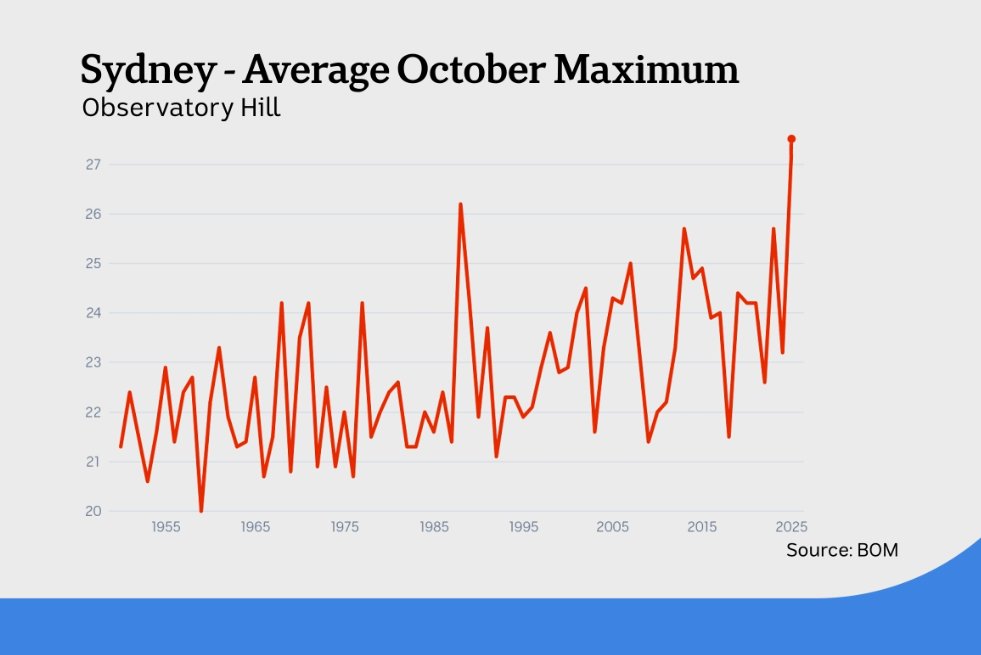
21 Oct 2025
An October daily record of 39C is predicted for #Sydney tomorrow - along with an extreme fire danger, strong winds and a possible severe thunderstorm. The monthly record will also be broken - a mean well above 27C which easily exceeds the current record of 26.2C from 1988.
1
3
14
886
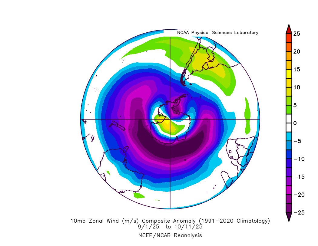
15 Oct 2025
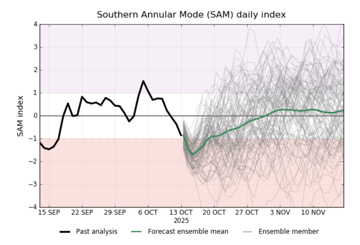
The strength of the polar vortex at 10mb has been 100km/h below average this spring. The ripple effect now seems to be peaking at the surface with SAM diving this week. The result (without a proper attribution study) = possible hottest October on record for #Sydney and #Brisbane.
3
2
18
1,711
8 Oct 2025
The latest IOD index is the lowest in at least 17 years (no weekly data available <2008). Without the recent stratospheric warming there's a chance parts of Australia would be under water.
3
4
27
1,788
23 Sep 2025
A more critical look at the 2025 ski season - one of the worst on record for lower slopes.
abc.net.au/news/2025-09-24/c…
2
2
4
391
25 Aug 2025
Its rare you see an airmass from as far south as the Antarctic coastline reaching mainland Australia. Snow could fall in 4 states plus the ACT.
2
6
625