
TorCAST: Real-time max plausible severe weather potential BEFORE radar confirms. Founder & Chief Engineer • predictive model
Joined December 2009
- Tweets 468
- Following 179
- Followers 96
- Likes 234
284 Photos and videos


Pinned Tweet

May 13
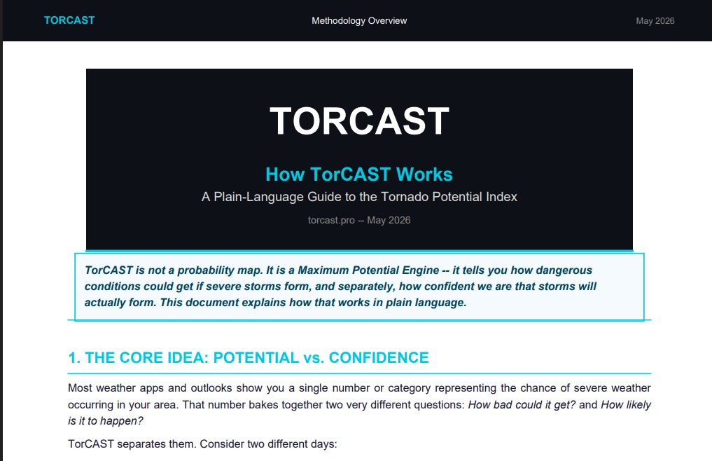
The TorCAST White Paper is now live on our website, detailing the methodology and theoretical basis of the system.
torcast.pro
For a more in-depth white paper, contact support@torcast.pro.
1
2
682
Brandon Walls retweeted

My producer @monsoonchaser is live streaming his storm chase! Give him some love! youtube.com/live/GQNSGh50PAs…
5
11
1,034
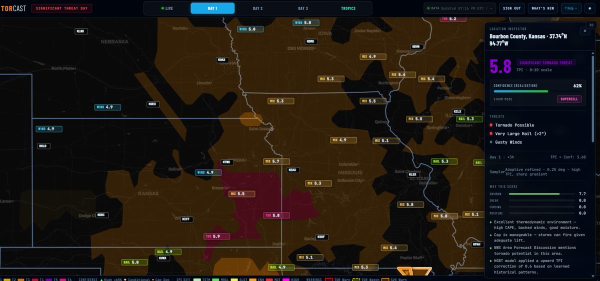
TorCAST flags Significant Tornado Potential (TPI 5.8) in eastern KS this evening ( 6hr forecast).
Bourbon County, KS: 5.8 | 62% conf | Supercell mode
High CAPE, backed winds, manageable cap — TorCAST model added 0.6 correction on historical patterns.
Live at app.torcast.pro
#TorCAST #Tornado #SevereWeather #KSwx #MOwx
1
1
50
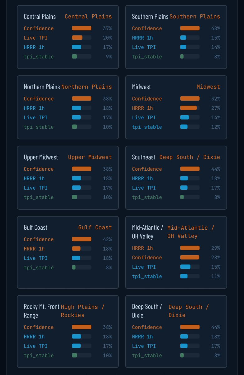
Internal diagnostic view from TorCAST V9 model.
We just pulled regional feature importances across CONUS.
"Confidence of Realization" dominates in nearly every region (often 37–48%).
This is exactly what I designed the system to do:
TorCAST runs a Max Potential engine a realization confidence layer. The model has learned that whether high potential actually verifies is usually the most important signal.
Live TPI such as reports, radar data, and ASOS and recent HRRR guidance consistently rank in the top 3.
Transparency on how the model reasons matters to us.
torcast.pro
#TorCAST #SevereWeather #Tornado #MachineLearning #WeatherML
1
54
Jun 12
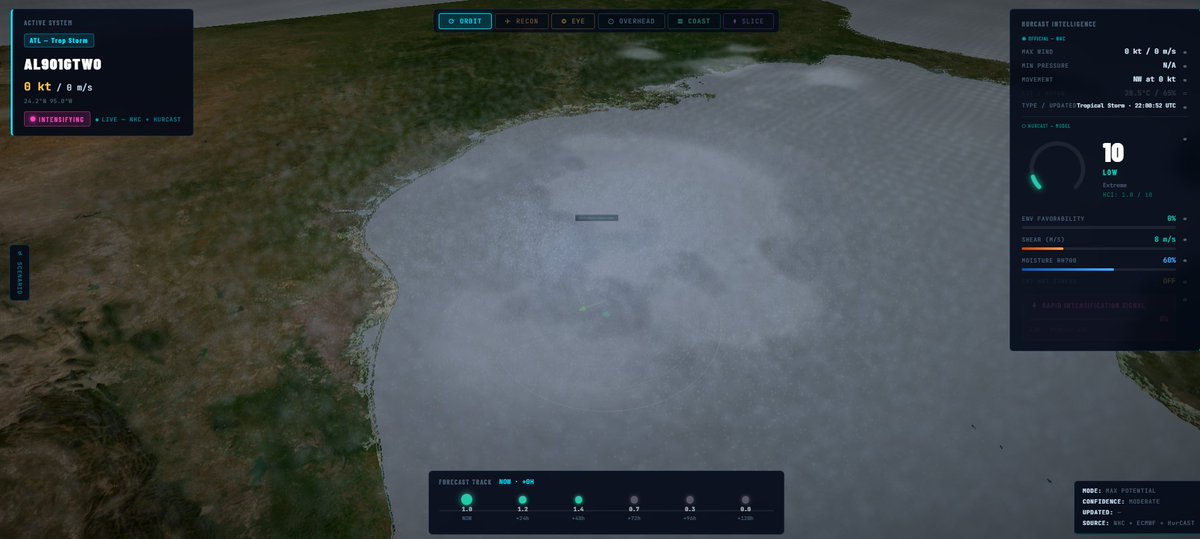
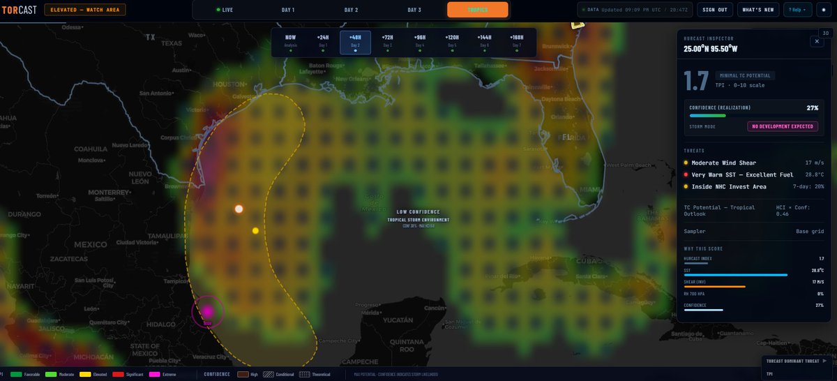
Gulf Invest Update
NHC: 20% chance of development in 7 days
HurCAST:
• TPI: 1.7 (Minimal TC Potential)
• Realization Confidence: 27%
• Storm Mode: NO DEVELOPMENT EXPECTED
Very warm SSTs but moderate shear low-confidence tropical environment overall. Low risk at this time.
Monitoring closely.
#Tropical #GulfOfMexico #HurricaneSeason
54
Jun 12
TorCAST keeping things mostly chill— no stand out tornado potential, some low confidence tornado capable contours.
#TorCAST

24
Jun 12
not my best day! ehhh!
🌪️ StormGuessr Daily #6
The daily weather game
🟩🟧🎯🎯🎯
932 / 1,000 · 🔥4
stormguessr.com/share?s=93.4…
🎯 No assists
1
1
2
74
Jun 12
I’m not complaining. This is just the reality I’m sitting in right now.
Building serious tools in a noisy space is slower and lonelier than I expected.
Some days the validation feels meaningful. Other days it just highlights how far the gap still is between “this works” and “people actually use it.”
Even good inventions have to fight the horse everyone’s already riding.
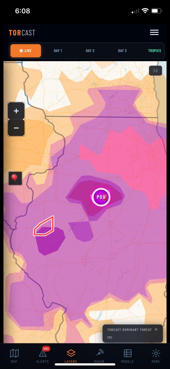
Anyway, numbers from last 24 hour's verification
487 scored events
• Ceiling Hit Rate: 97.1%
• Strict Hit Rate: 73.9% (Bust rate 2.9%)
• Mean TPI Error: ±1.27
• Mean Brier Score: 0.025
TorCAST verification runs on two tracks.
One uses official NWS Tornado and Severe Thunderstorm warnings as a signal (since not every warned storm produces an LSR).
The other scores against actual verified severe reports (LSRs) that meet NWS criteria.
#TorCAST #SevereWeather #WeatherTech #BuildInPublic
1
4
116
Jun 12
This is when a normal human being would drop the phone/camera and run to help.
Jun 12

WATCH: Man rescued from the rubble of a home in Streator, Illinois following the tornado.
1
66
Jun 12
TorCAST early morning cycle, nothing really standing out so far mainly 2.5-3.5 TPI across the SPC slight risk areas. Everything right now showing low-medium confidence. We will see how this evolves through the day.
#TorCAST #SevereWeather
16
Jun 12
TorCAST continues to track the highest potential ahead of the current warnings across northern Illinois and northwest Indiana.
Darker opacity within the contours indicates higher confidence in the signal. Most areas inside the higher TPI contours are currently showing 70% confidence.
#TorCAST #SevereWeather #Tornado #INwx #ILwx
209
Jun 11
Wow at the chaser convergence — looks like Atlanta traffic on Waze.
50
Jun 11
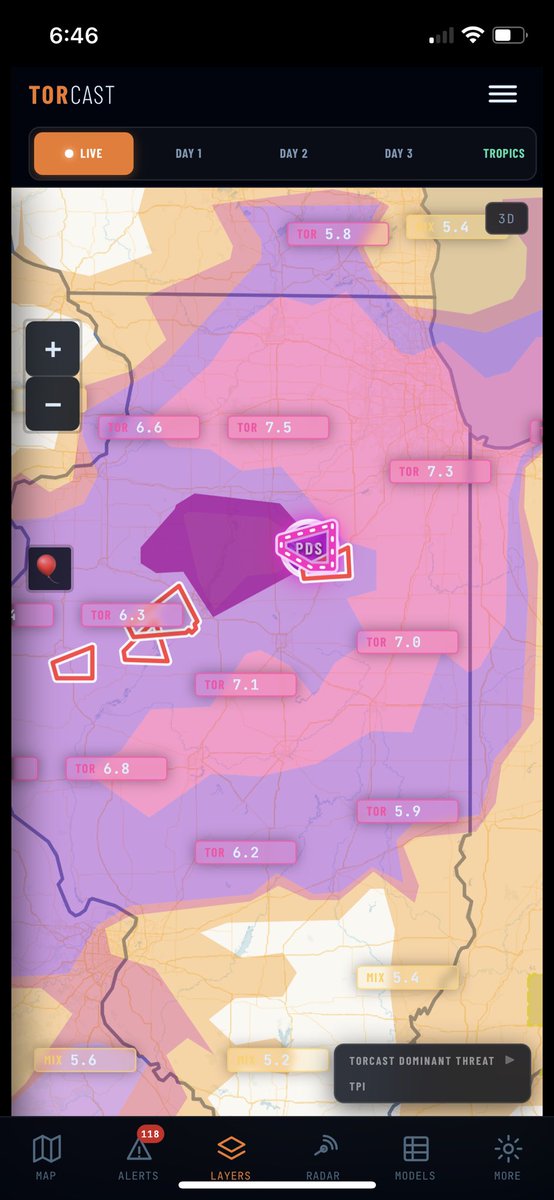
TorCAST Update – 7:29 PM EASTERN
You’ll notice the contours look different across the map.
Here’s the breakdown:
The colored contours and TPI numbers (7.0–7.1 in several spots) reflect TorCAST’s calculated tornado potential based on current environmental conditions.
Tighter, more rounded high-TPI areas often indicate environments that still support discrete supercells, while broader or lower-value shading usually shows areas where earlier storms may have already modified the atmosphere through outflow or a shift in storm mode.
TorCAST is adjusting the potential contours in real time as the environment changes. The remaining higher TPI areas are where the model still sees favorable conditions ahead of or outside the currently warned zones.
Just one more real-time layer.
Stay weather aware.
#TorCAST #ILwx
Jun 11

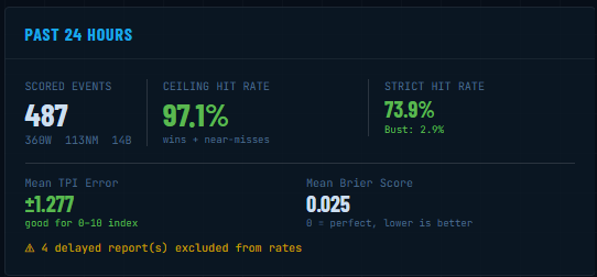
As of 6: 47 PM Eastern:
TorCAST is currently showing TPI 7.0–7.5 positioned ahead of the active PDS Tornado Warning.
The strongest contours (pink) are sitting forward of the current warned areas, including the La Salle/Livingston PDS warning and the cluster of radar-indicated tornado warnings in Fulton, Peoria and surrounding counties
app.torcast.pro
#TorCAST #ILwx #SevereWeather
196
Brandon Walls retweeted
Jun 11
As of 6: 47 PM Eastern:
TorCAST is currently showing TPI 7.0–7.5 positioned ahead of the active PDS Tornado Warning.
The strongest contours (pink) are sitting forward of the current warned areas, including the La Salle/Livingston PDS warning and the cluster of radar-indicated tornado warnings in Fulton, Peoria and surrounding counties
app.torcast.pro
#TorCAST #ILwx #SevereWeather
1
1
678
Jun 11
Had to stop everything and post this…
Tornado Emergency!! Marshall, IL
Seek Shelter Immediately.. Very Dangerous Situation.
If I had shared this the moment the cycle finished, we’d be looking at over 2 hours of lead time — right in the center of the highest TPI contours.
For anyone who hasn’t checked out TorCAST yet, I genuinely welcome you to take a look. We’re not trying to replace the tools you already use. We’re not perfect. We just want to be one more layer of actionable intelligence for you.
No risk. No paid endorsements. No pats on the back needed.
If it helps someone make a better decision and saves a life… that’s the entire goal.
#TorCAST #SevereWeather #Tornado #ILwx
Jun 11
Been traveling today so haven’t had the chance post early morning cycles as usual but currently TorCAST eyeing central IL in the TorCAST Live
Watching as closely as I can
#TorCAST #ILwx
342