
Utah Forecaster @OpenSnow
Joined January 2013
- Tweets 16,195
- Following 179
- Followers 57,263
- Likes 3,596
3,693 Photos and videos


Jun 12
StormNet, a product of OpenSnow, scored 1st 🥇 overall in NOAA spring severe weather test. We have felt for a couple years that we had something special, and it’s really cool to see it confirmed against stiff competition.
Jun 12

Super excited to announce that we have received the preliminary results from SPC's Spring Forecasting Experiment!
StormNet scored 1st place overall, plus:
-1st place at each lead-time.
-1st place each week of the experiment.
Even beating CSU-MLP (GEFS-MLP) and WxNext2!

19
2,963
Jun 5
Hot today and tomorrow, but a system will bring much colder air by middle of next week and the highest elevations of the Wasatch and Uintas will once again have a chance for light snow accumulation.
1
30
2,493
Utah Daily Snow retweeted

Jun 5
Breaking: The June ECMWF update has trended *even stronger* with this year's El Niño.
Almost every scenario now reaches past 3˚C, with a cluster of high-end scenarios in excess of 4˚C.
This outlook now depicts the strongest El Niño on record.

42
254
805
145,078
May 29
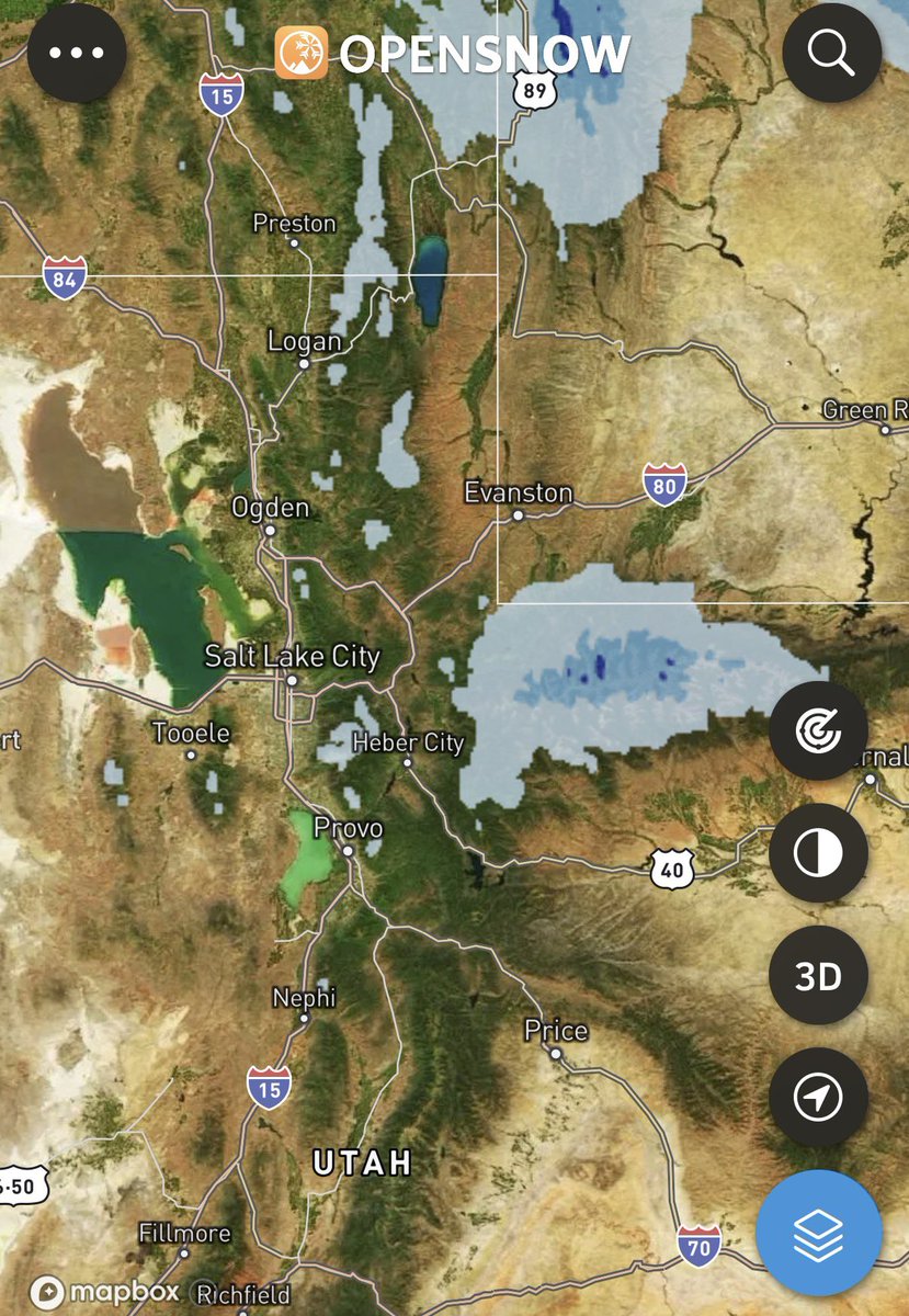
Late tonight into tomorrow we have a cool, closed low that will bring the threat of snow to the highest elevations of the Wasatch and Uintas. Several inches possible! The high Uinta could see pockets of up to a FOOT according to some models. Be aware if you’re venturing outdoors!

2
3
74
7,506

Powder Mountain to retire the Sunrise Poma next summer, ending public lift access to Cobabe Canyon. Homeowners will have access via private lifts and anyone can still hike there. powdermountain.com/blog/2026…
8
2
25
44,561
Utah Daily Snow retweeted

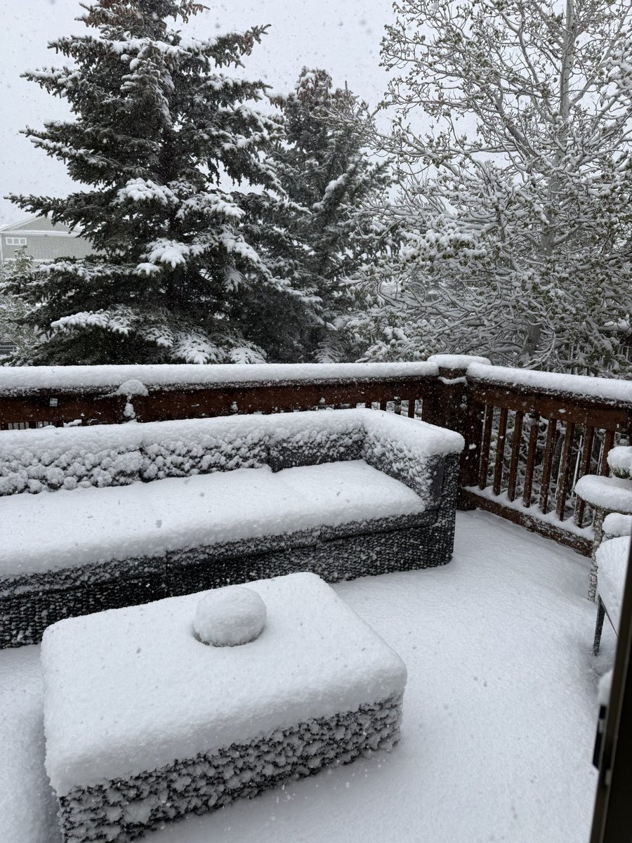
May 18
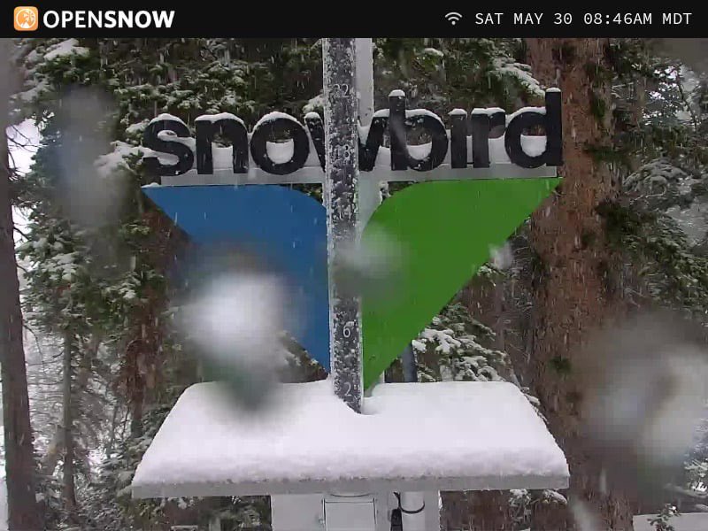
Hello winter. ❄️
Woke up to 5” of snow and it’s still coming down this morning at my house in Park City. Believe it or not, this is now my second biggest snowfall of the season… and it’s May 18.”
12
19
357
13,622
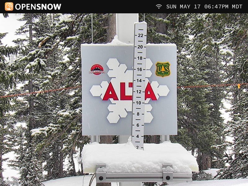
May 18
A number of locations in Uintas showing over an inch of water, likely meaning a foot or more of snow. Alta-Collins showing 6” of snow from about 0.5” of water. PC saw several inches as well.
1
1
112
6,627
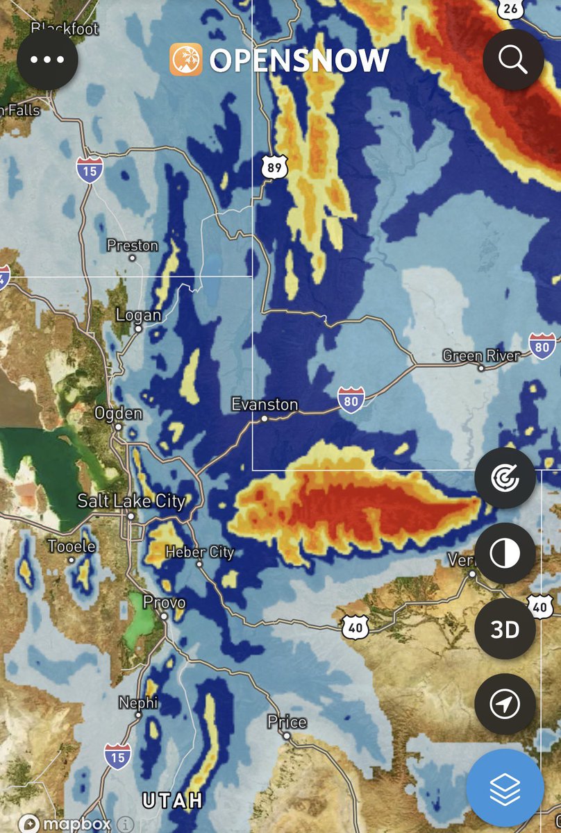
May 18
And here it is… quite a bit more snow possible tonight into tomorrow.
May 15

Very cold air and legit chances for snow in the high elevations late Sunday through Monday
1
6
91
10,537
May 15
Very cold air and legit chances for snow in the high elevations late Sunday through Monday
2
10
102
17,705
May 14
Yes, El Niño looks likely. Yes, it could be a “super” Niño event. No, it doesn’t guarantee any particular outcome for next winter. We are going to hear a lot of noise about this over the next 6 months.

El Niño is likely to emerge soon (82% chance in May-July 2026) and continue through Northern Hemisphere winter 2026-27 (96% chance in December 2026 – February 2027). An #ElNino Watch remains in effect. #ENSO cpc.ncep.noaa.gov/products/a…
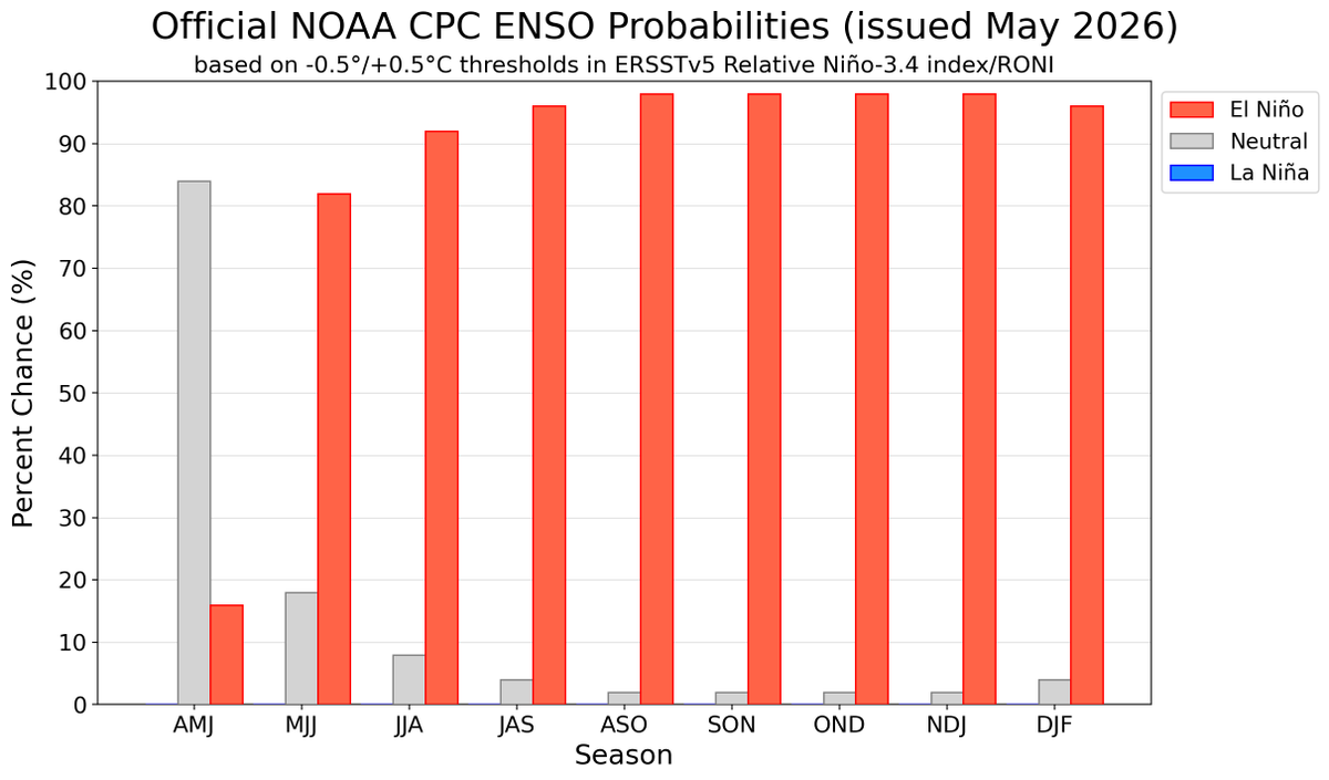
ALT Bar chart reflecting the percentage chances of La Nina, Neutral, and El Nino from April-May-June 2026 through December-January-February 2026-2027. For more information on explicit chances of exceeding relative Nino 3.4 thresholds please see https://www.cpc.ncep.noaa.gov/products/analysis_monitoring/enso_advisory/strengths/index.php
10
4
88
19,534
Utah Daily Snow retweeted

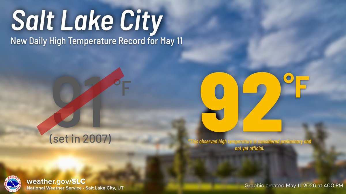
🌡️SLC reached 92°F this afternoon, which sets a new daily high temperature record for May 11th. The previous record was 91°F, set in 2007. #utwx
4
19
4,839
May 7
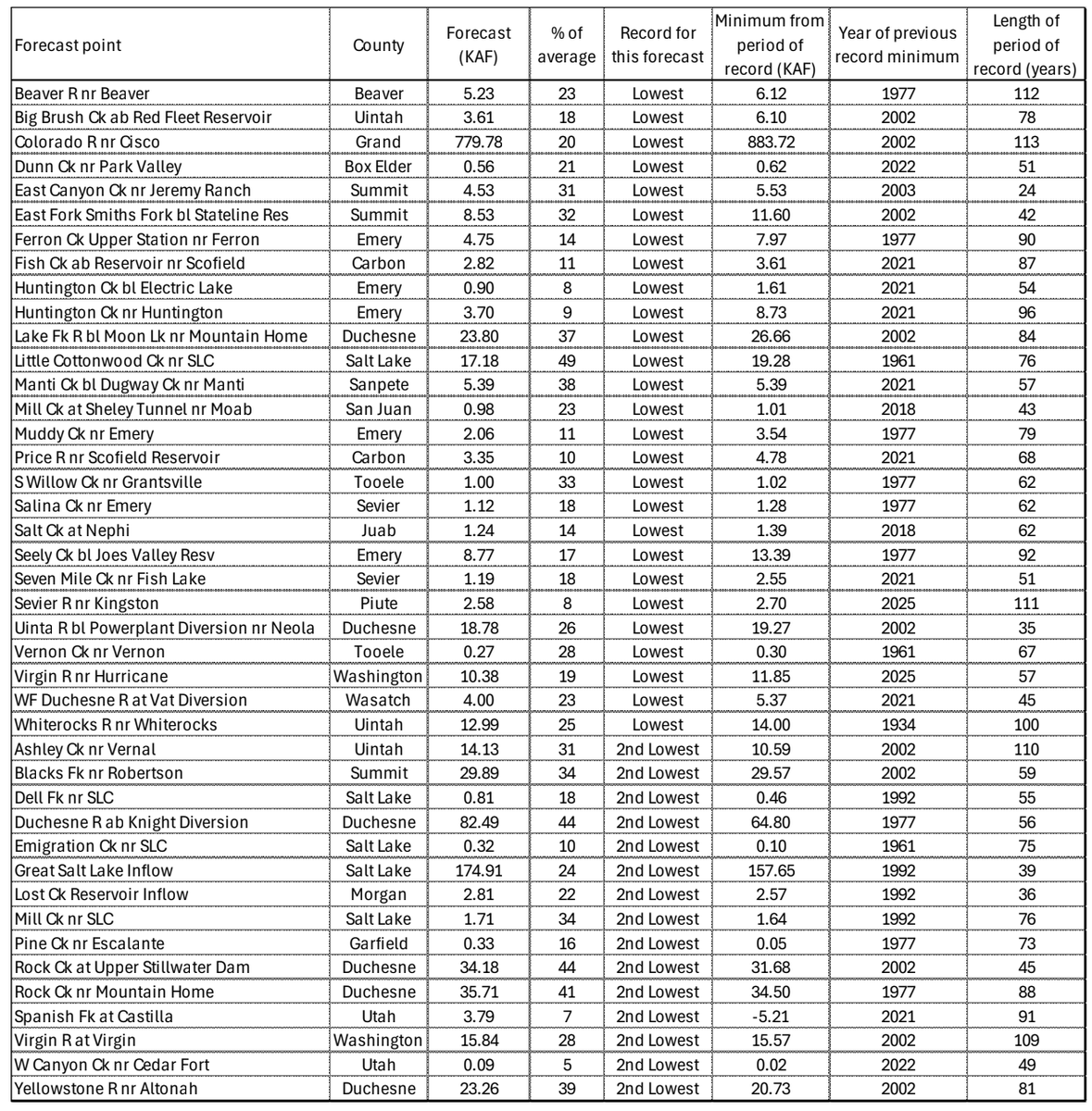
NRCS does great work, but their water outlook is concerning heading into summer. Below are the streamflows expected to have their worst, or second-to-worst, total runoff (Apr-Jul) on record. Total runoff in the GSL is expected to only be 24% of normal. <eek emoji>
5
1
14
4,596
May 7
It is worth noting that we have seen 94% of average total precipitation statewide for the water year (since Oct 1). But so much of that fell as rain and/or melted off prior to the normal runoff window that there's not much snowpack left to melt off.
2
6
950
May 6
Seasonal webcam timelapses
Coming soon to OpenSnow. Really fun to watch daily snapshots compiled over months.
4
16
148
10,714
May 6
Here is Mount Superior’s South face losing snow over the course of the spring.
1
1
23
2,657
May 4
For those wondering, I posted my final post of the season and the full season recap on the Utah Daily Snow today on OpenSnow. It was an interesting season to say the least. We all got through it together! Let's just hope next year is a return to normalcy. opensnow.com/dailysnow/utah/…
3
44
3,612
May 4
This was officially the least snowy season (Oct-Apr) since 1980 at Alta-Collins, with 321". The previous record low was 323.5" in 2014-15. However, there were THIRTEEN seasons in that period with less total water. A wild stat illustrating just how dense the snow was this season.
4
7
109
9,157