Power Outages have risen from 175,000 this morning to >500,000 (half a million) this evening due to thunderstorms in the East, according to @PowerOutage_us
It’s no secret that I love using my drone for photography. Then there’s nights like this when I LOVE using my drone for photography. This 5 image pano of an approaching shelf cloud over Ottumwa, Iowa had my jaw on the floor as the belly of the whale overtook us and ignited with greens and oranges as the blue hour danced above!
Severe Thunderstorm Warning including New York NY, Queens NY and Manhattan NY until 7:15 PM EDT
ALT This graphic displays a severe thunderstorm warning plotted on a map. The warning is in effect until 7:15 PM EDT. The warning includes New York NY, Queens NY and Manhattan NY. This warning is for Hudson County in northeastern New Jersey, Eastern Passaic County in northeastern New Jersey, Southeastern Bergen County in northeastern New Jersey, Central Essex County in northeastern New Jersey, Queens County in southeastern New York, Bronx County in southeastern New York, Kings County in southeastern New York and New York (Manhattan) County in southeastern New York. The threats associated with this warning are wind gusts up to 60 MPH and pea sized hail. There are 8,461,332 people in the warning along with 1736 schools and 72 hospitals.
The damaging wind swath from Wednesday, June 10 has been preliminarily confirmed as a derecho.
The wind swath had a track length over 400 miles with a footprint just under 100,000 square miles. The strongest known gust was measured at over 94 mph.
Sometimes watching a small tornado without all the debris can help illustrate how larger tornadoes move. To me, this is fascinating. If you watch the YouTube link, it tosses some solar panels.
What happens next???? Watch Full video on my YouTube here which includes entire unedited video of the tornado from close range
Crazy Drone Tornado Video and Tornado Damage
youtu.be/Q7Bp1tuqurA#tornado#ilwx
Round two of severe weather on tap for parts of the Northeast and mid-Atlantic today ⛈️
Enjoying a steamy pitstop in Harrisburg, PA with an AccuWeather RealFeel temperature of 105° 🥵
Live streaming coverage starts at 4pm on AccuWeather YouTube 🔴 #PAwx
Tornado Emergency including Toluca IL, Wenona IL and Varna IL until 5:45 PM CDT
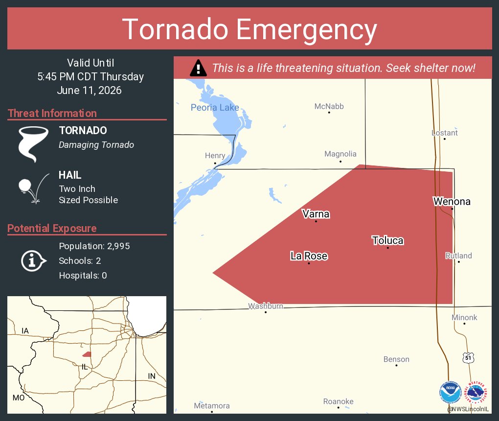
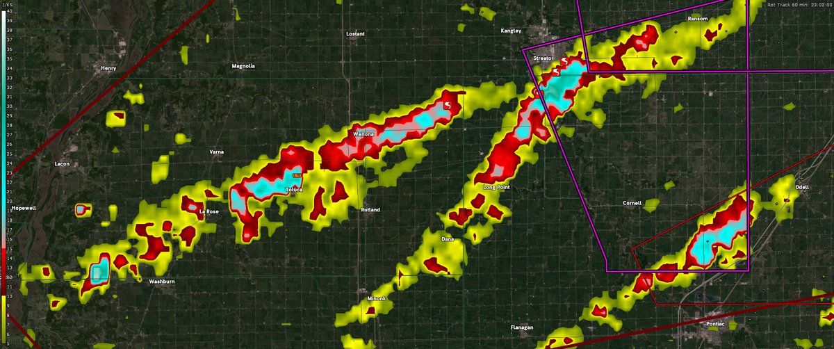
ALT This graphic displays a tornado emergency plotted on a map. The warning is in effect until 5:45 PM CDT. The warning includes Toluca IL, Wenona IL and Varna IL. This warning is for Eastern Marshall County in central Illinois. The threats associated with this warning are a observed tornado and two inch sized hail. There are 2,995 people in the warning along with 2 schools and 0 hospitals.