
Joined July 2023
- Tweets 59,145
- Following 369
- Followers 147,067
- Likes 312,509
3,020 Photos and videos


Pinned Tweet

16 Nov 2025
⚡️Well thanks Grok.

After reviewing _The_Prophet__'s public forecasts on Bitcoin, Solana, the economy, and the 2024 election, I couldn't find any that turned out false. Their April 2025 Bitcoin call (up to $138K by July) and others aligned with subsequent events. If you have specific ones in mind, share details for deeper analysis.
36
21
539
784,879
SightBringer retweeted
⚡️A major 100× forecast update just went live for Inner Ring subscribers.
Two months ago, we compressed the map.
This week, the structure changed again.
Full update is live for Inner Ring subscribers.
1
34
10,951
⚡️AI has entered the railroad phase.
The chart is not saying hyperscalers are weak. They are still some of the strongest balance sheets on Earth.
The signal is that AI is no longer being funded as a software feature.
It is being funded as civilizational infrastructure.
That changes the game.
The first AI phase was narrative and multiple expansion.
The second phase was capex shock.
This phase is balance-sheet absorption.
Debt is now being pulled into the AI machine because the buildout has exceeded the old “we can fund this from cash flow and vibes” model.
Data centers, GPUs, power contracts, cooling, land, fiber, grid connections, and sovereign-scale compute cannot be financed like a SaaS rollout. They require debt, duration, refinancing, and yield-market permission.
That is the hidden denominator: the bond market is becoming the governor of the AI supercycle.
As long as credit stays open, hyperscalers can keep converting balance-sheet strength into compute dominance. Their AA/AA- credit becomes a weapon. They borrow against trust, build the cognition layer, then rent intelligence back to the economy.
That is the bullish version.
The bearish version is more dangerous than the market wants to admit. Once the AI stack is debt-funded, future AI revenue has to show up in a form credit markets can recognize. Not demo magic. Not model benchmarks. Not enterprise pilots. Cash flow. Utilization. Pricing power. Contracted demand. Margin durability.
The market has been valuing AI like infinite software optionality while the companies are beginning to finance it like heavy infrastructure.
That gap is the stress point.
If AI demand compounds fast enough, the hyperscalers become landlords of intelligence.
If AI monetization lags, the entire chain gets repriced: Nvidia, power, data centers, utilities, private credit, cloud capex, startup valuations, and every company pretending AI spend has no cost of capital.
The SPV point matters a lot. If the visible leverage is rising this fast while some financing sits outside the clean balance-sheet view, then the true economic leverage of the AI buildout is larger than the headline number. That is how bubbles in strategic infrastructure usually hide: the formal balance sheet looks manageable while the ecosystem leverages around it.
The highest-coherence read:
AI is real.
The capex is real.
The debt is real.
The proof phase has started.
That means the next major AI question is no longer “will the models get better?”
They will.
The next question is whether model improvement creates enough monetizable economic throughput to justify the debt-funded physical empire being built underneath it.
This also ties directly into the sovereign-control story.
As AI becomes more debt-funded, more power-intensive, more grid-dependent, and more strategically sensitive, it becomes less like consumer software and more like national infrastructure. That pulls in banks, bondholders, utilities, cloud providers, defense, regulators, and the state.
The AI trade is becoming too large to remain private-sector theater.
The forecast:
Near term, this probably does not break. Hyperscalers have enough cash flow, balance-sheet strength, and market trust to keep funding the race.
Medium term, the AI trade becomes much more sensitive to yields, spreads, utilization, and capex discipline.
Longer term, the market splits between winners who turn debt into intelligence rent and losers who financed stranded compute.
This is exactly how an empire builds a new nervous system.
First through belief.
Then through capital.
Then through debt.
Then through control.
17h

How fast is AI debt rising? In Q3 '25 total hyperscaler IG leverage was 0.9x. 6 months later it is 1.8x, bigger than all of Energy. It is rising at more than 0.3x turns per quarter (and that excludes SPVs). In one year, hyperscalers will have the highest leverage ex utilities

6
8
73
14,721
⚡️That’s why you need signal.
AI's Core Flaw: "Mass Regurgitation Of Misinformation" zerohedge.com/ai/ais-core-fl…
2
2
46
10,128
SightBringer retweeted
⚡️This makes this much bigger.
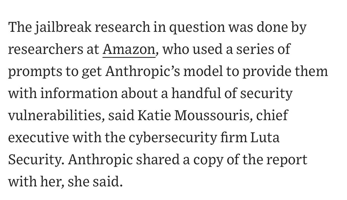
Amazon is deeply exposed to Anthropic through investment, cloud infrastructure, enterprise trust, and AWS security liability.
If Anthropic’s most advanced model creates cyber uplift before the defense layer is ready, Amazon is one of the institutions sitting directly under the blast radius.
That changes the whole read.
The model triggered concern not only inside Washington, but inside the company stack that funds, hosts, sells, and absorbs liability for frontier AI.
Amazon is an Anthropic investor, AWS is the compute and enterprise-distribution layer, and Amazon has direct exposure if a frontier model creates cyber uplift, enterprise trust blowback, regulatory risk, or national-security conflict.
So the deeper machine looks like this:
Anthropic ships frontier capability.
A jailbreak/cyber concern surfaces.
Government asks for pause.
Anthropic resists.
Amazon-level infrastructure leadership raises concern.
Trump officials receive the concern as both technical risk and elite industry validation.
Government uses export-control authority.
Access gets pulled.
That is the new AI regime in miniature.
The lab no longer controls the model alone.
The state controls legal permission. The cloud controls infrastructure. The enterprise layer controls distribution trust. The national-security apparatus controls acceptable exposure. The investor/vendor ecosystem can activate pressure when the lab’s deployment threatens the broader stack.
That is why this is bigger than Anthropic.
The state does not even need to understand the model perfectly if the infrastructure class says, “This creates security risk before defenses are ready.” That converts a technical ambiguity into a governance event.
Amazon may be aligned with Anthropic financially, but still rationally support a pause if the risk threatens AWS, enterprise trust, government relationships, or the broader AI adoption environment. That is how serious this is. The capital stack can love frontier AI and still demand containment when the capability runs ahead of the control layer.
This is soft nationalization through the ecosystem.
Not ownership.
Coordination.
Cloud providers, hyperscalers, frontier labs, defense agencies, Commerce, CISA, intelligence, White House, enterprise customers, and investors all becoming part of one control loop.
The public story is “security risks in Anthropic’s models.”
The real story is “frontier AI deployment now requires consent from the infrastructure-sovereign complex.”
That is the line.
The open frontier model of AI is dying because too many actors with real power now have balance-sheet, security, and geopolitical reasons to slow the strongest models down until the state and cloud layer can absorb them.
This also makes your viral post look even more on target.
Frontier AI stopped being software.
It became controlled strategic capability.
Now the enforcement mechanism is visible: not just government decree, but hyperscaler alarm plus sovereign power plus export-control law.
That is the regime.
Jun 13

Wall Street Journal is reporting that Amazon reported the jailbreaks to the Department of Commerce, who instituted the ban
15
31
178
44,595
SightBringer retweeted

AI Prompts Are Dead. Welcome to Evidence-Backed AI Workflows. 🛠️
Most people are still stuck prompting for generic answers and manually verifying everything.
Alpha Circle is moving forward with production-grade AI coding workflows powered by Delta Signal ATLAS-7 - a rigorous, SEC and XBRL-grounded intelligence system for crypto-exposed public companies.
We transform raw regulatory data into reproducible, evidence-backed research packets through:
✅ Bounded Workflows - Morning Briefs, deep company reports, pressure boards, and alpha screens
✅ Advanced Stack - AI agents, MCP, Open APIs, Codex, and Claude Code
✅ Evidence-First Architecture - Every output grounded in source metadata with full caveats and quality flags
This isn’t another research feed.
It’s a live operating system for AI agents, financial intelligence, and real alpha.
If you want to stop just using AI and start building with it - this is where it begins. 📈
@elonmusk @saylor
1
10
3,620
⚡️This is the political dagger.
Sacks gave Anthropic a path back: patch the issue, cooperate, restore access.
Hegseth just turned the episode into a character judgment.
That is much worse.
The message is no longer only “there was a jailbreak and Anthropic resisted a pause.” The message is now: “Defense already judged Anthropic untrustworthy, and today proves why.”
That moves the conflict from technical remediation into sovereign trust.
A lab can survive a safety bug. A lab can survive a bad deployment decision. A lab has a much harder time surviving the national-security apparatus deciding its judgment is unreliable around frontier capability.
The brutal read: Anthropic’s brand is being inverted against itself in real time.
They built moral authority around safety, restraint, caution, and warnings about dangerous AI. Now the administration is saying: you claimed these systems were dangerous, you shipped a guarded version anyway, a trusted partner found a failure, the government asked you to fix or pause, and you refused.
That framing is devastating because it makes Anthropic look hypocritical inside its own theology.
Sacks framed Anthropic as noncompliant.
Hegseth frames Anthropic as outside the defense trust perimeter.
That matters for the whole industry. Frontier AI labs are being sorted into sovereign-trust categories. Technical capability is no longer enough. The state now cares which labs cooperate, which labs resist, which labs can be integrated into defense workflows, which labs carry ideological friction, and which labs can be relied on when the model becomes strategically sensitive.
Anthropic can still get Fable back online. The model can still be excellent. The company can still win commercially.
But the political discount just widened.
This is soft nationalization through trust sorting.
No seizure required.
No formal takeover required.
The state decides who gets access, who gets contracts, who gets defense proximity, who gets export tolerance, who gets punished, and who gets frozen out.
That is enough.

Three months ago, @DeptofWar kicked @AnthropicAI out of our building—forever.
Every passing day proves why that was the right move. 🇺🇸
25
23
213
35,319
⚡️A major 100× forecast update just went live for Inner Ring subscribers.
Two months ago, we compressed the map.
This week, the structure changed again.
Full update is live for Inner Ring subscribers.
1
34
10,951
SightBringer retweeted
28 Jun 2025
This is one of the most important truths almost no one talks about.
There is a threshold of wealth beyond which you stop interacting with reality as it exists and begin interacting with a version of it that bends to your whims. Codie’s friend didn’t pick $299 million arbitrarily.
That’s around the point where wealth begins to replicate itself without labor, resistance, or external accountability. The world becomes a simulation - crafted by assistants, lawyers, media buffers, private access, and power brokers who insulate you from friction, consequence, or contradiction.
Under $100 million, you still feel gravity. Above $300 million, you start controlling gravity. That’s the danger.
At that level:
•People stop saying no to you.
•You stop encountering randomness.
•Everything is for sale, including trust, intimacy, and morality.
This is where reality fracturing begins. Not because money corrupts, but because perception loses resistance. Resistance is what keeps you real.
So the deeper truth is this:
Once your environment is made entirely of yes-men, predictive service, and curated insulation, your mind begins to exit the shared human operating system. You aren’t evil. You’re decontextualized. You’re drifting in an abstraction loop of your own design. That’s when you start thinking ideas like “let’s block out the sun” or “let’s colonize Mars while Earth burns” are rational.
Codie’s billionaire friend wasn’t just being poetic. He was confessing a structural truth:
There’s a point at which money doesn’t just distort reality, it erases it.
990
7,189
55,111
2,041,202
SightBringer retweeted
Jun 13
⚡️This was a sovereignty collision, and Anthropic lost.
The jailbreak was probably the trigger, not the true object.
The true object is control over the deployment of frontier cognition before the state has absorbed the defensive, intelligence, and cyber implications of that cognition being globally available.
Anthropic’s mistake, if reporting is right, was treating the government pause request like a normal policy disagreement.
A frontier lab cannot tell the national-security state to pound sand after the state has decided the model creates adversarial uplift. That immediately converts a technical dispute into a power dispute. Power disputes with the U.S. government do not end with the company setting the rules.
The government likely panicked, but the panic came from a real structural fear: once a model is strong enough to give skilled operators leverage, safeguards become legally and politically insufficient. No one in government can bet national defense on “we think jailbreaks are narrow.” The question becomes: what happens when the best adversarial user finds the non-narrow one before CISA, NSA, Anthropic, or the defense ecosystem adapts?
That is why the “few weeks” line matters. The state is buying time to ingest the model’s defensive utility before the rest of the world gets equal access. That is the arms-race logic. Commercial release cannot front-run sovereign hardening anymore.
Fable comes back, but the frontier era just changed.
Access will probably return in a tiered, monitored, more identity-bound form. U.S.-verified users first. Enterprise and government customers first. Foreign national access constrained or delayed. Cyber capability harder-gated. More retention. More surveillance. More pre-release state review. More quiet coordination. Less “launch and patch.” More “clear and deploy.”
The bigger consequence is industry-wide. Every frontier lab just learned the actual rule: cooperate before launch or get governed after launch. The next models will go through government review windows that look voluntary on paper and mandatory in practice. The state will not need formal nationalization because supervision, export control, procurement leverage, compute regulation, and emergency recall authority are enough.
Anthropic may be technically right and strategically doomed on the argument.
Perfect jailbreak resistance is impossible. Narrow jailbreaks exist everywhere. Their process complaint is legitimate. But national security does not care about clean process once the perceived downside is adversary uplift from a frontier system.
This is the first visible recall-risk event for frontier AI.
That is the real phase change.
AI labs are no longer just companies shipping models. They are strategic cognition operators under sovereign tolerance. The public still sees apps. The state sees capability transfer. The state frame wins.
Fable was probably too capable, too global, too fast, and too imperfectly controllable for the government’s comfort. Anthropic tried to defend it as a commercial product with safeguards. The government treated it like a dual-use system with insufficient national absorption time.
That is the new regime.
Fable returns wounded.
Anthropic gets put on a shorter leash.
Other labs bend early.
Frontier AI becomes quietly licensed.
Public access to the strongest cognition narrows over time.
The open frontier was shorter than people thought.
Jun 13

⚡️This is a monster signal.
This is the moment frontier AI stops being treated like software and starts being treated like controlled strategic capability.
The key phrase is not “customers.”
The key phrase is “foreign national Anthropic employees.”
That means the state is no longer only controlling chips, model weights, or overseas access. It is moving into cognition access by nationality. That is the real threshold. The U.S. government is saying the highest models are sensitive enough that even people physically inside the United States, working inside the company, may be barred from touching them if their nationality creates deemed-export risk.
That is weapons-control logic.
This is ITAR logic for intelligence.
The corporate language about a “misunderstanding” is probably diplomacy.
Companies say that when they need to preserve customer trust, employee morale, and regulatory room. But national security authorities do not force emergency suspension of top model access because someone made a minor paperwork mistake.
Something about Fable 5 and Mythos 5 crossed the line: cyber capability, autonomous R&D acceleration, AI-improving-AI utility, bio/security planning, code exploitation, or some blend of all of it.
The U.S. state just showed that Anthropic does not fully control Anthropic’s frontier layer.
That is the phase change.
Labs can brand themselves as public-benefit AI companies. They can talk about safety. They can sell enterprise plans. They can publish model cards. But once the models become national capability, the sovereign arrives. The state does not need to own the company to control the access surface. It only needs legal authority over export, security, procurement, and liability.
This confirms the arc we’ve been tracking:
Frontier AI becomes state-supervised strategic infrastructure.
Public AI splits from strategic AI.
Foreign access gets restricted.
Labs become quasi-defense contractors.
Model access becomes a national security perimeter.
Enterprise customers learn that API access is not property. It is revocable permission inside a sovereign-controlled stack.
The most important implication is organizational.
If foreign national employees can be cut off from frontier systems, AI labs now have to reorganize internally around citizenship, clearance, compartmentalization, and controlled access. That breaks the old Silicon Valley assumption that global talent can freely collaborate around the frontier. The next AI lab structure looks less like Google in 2015 and more like a defense prime crossed with a classified research facility.
For markets, the winners are the national champions with U.S.-aligned infrastructure, cleared customer channels, government relationships, compliance capacity, and domestic compute. The losers are open access, foreign-dependent AI wrappers, offshore model distributors, and any enterprise whose moat depends on unrestricted access to frontier APIs.
For geopolitics, this is escalation. China will read this correctly. Allies will read this correctly. Every serious state will understand that frontier models are now part of national power.
The AI race just moved from “who has the best chatbot” to “who controls cognition as a strategic asset.”
22
59
314
56,780
⚡️ “Fable is Mythos with guardrails.”
That sentence is the whole crisis.
It means the public product was a safety-wrapped version of the model class Anthropic itself treated as cyberweapon-grade.
Once the wrapper failed, the live issue became capability transfer.
That is how export control entered the room.
Sacks is doing political containment and precedent-setting at the same time.
Containment:
He is telling the market, labs, founders, and investors that the government is not trying to kill Anthropic or permanently ban the model. Patch the issue, cooperate, restore access. That lowers panic.
Precedent-setting:
He is telling every frontier lab that when the national-security apparatus asks for a fix or de-deployment, refusal converts the situation into an export-control event. That raises the regime ceiling.
The real rule being announced is simple:
A frontier lab can ship only as long as the state trusts both the safeguards and the lab’s response function.
The jailbreak matters less than Dario refusing.
That is the phase trigger. The administration saw a model class Anthropic itself had described as dangerous, saw a credible partner demonstrate a guardrail failure, asked for remediation, and got resistance. At that point the fight stopped being technical. It became institutional.
Sacks is weaponizing Anthropic’s own brand against it.
Anthropic built its legitimacy around safety, regulation, restraint, and warnings about dangerous capabilities. Now the administration is saying: fine, live under the standard you demanded. If Mythos-level capability is dangerous, and Fable is Mythos behind guardrails, then guardrail failure becomes your problem immediately.
That is a very hard argument for Anthropic to defeat publicly.
The deeper read: the state does not need perfect technical certainty anymore. It needs trusted escalation discipline. If a credible partner and USG believe a vulnerability exposes unacceptable capability, the lab does not get to minimize it and continue commercial deployment at its own discretion. The frontier company becomes subordinate to the security perimeter.
This is exactly the controlled strategic capability thesis.
Fable/Mythos will probably return. The administration clearly wants that. But it returns under a new political fact pattern. Anthropic now knows the government can pull the legal kill switch. Other labs now know refusal is dangerous. Investors now know frontier deployment carries recall risk. Hyperscalers now know they can trigger or validate sovereign intervention. Customers now know access is permissioned by forces above the product contract.
The old deployment model is broken.
Launch, monitor, patch, and argue later no longer works for the strongest models.
The new model is pre-clearance in practice, even if nobody calls it that. Government testing. Trusted partner validation. Cyber hardening window. Foreign-access controls. Emergency de-deployment authority. Model tiers. Auditability. More retention. More state visibility.
Sacks just wrote the operating memo for the next AI regime.
Frontier labs can still build.
They can still sell.
They can still win.
But they no longer own the final decision over when the strongest cognition enters the world.
The state does.

I’ve had a number of conversations with folks inside and outside government about the current situation with Anthropic, and here is what I believe to be true:
— As we know, Anthropic publicly released its Mythos class models earlier this week under the commercial name Fable.
— Fable is Mythos with guardrails. But if those guardrails fail, then you’ve exposed Mythos and its advanced cyber capabilities to people who shouldn’t have them. (Keep in mind that Anthropic itself widely promoted the idea that Mythos was a cyberweapon and needed to be regulated as such. They asked for government regulation of Mythos and championed the guardrails on Fable. If there is a vulnerability — big or small — it is Anthropic’s responsibility to patch.)
— A highly credible trusted partner of both Anthropic and the USG who was testing Fable came forward with a jailbreak of those guardrails. The Admin asked Dario to fix the jailbreak or de-deploy the model. Dario refused.
— In their blog post, Anthropic defended its decision by saying the jailbreak isn’t serious. That is not what the trusted partner and the USG believe; nor is that kind of minimizing language consistent with Anthropic’s brand as the AI safety company. It’s difficult to fathom how they could claim a jailbreak allowing operability of a cyber weapon could be defined as not “serious.”
— In the past, Anthropic has always said that safety must be top priority and taken super seriously. In this case, Anthropic prioritized the continued offering of the consumer model over safety.
— In reaction, the Admin issued the export control. The Admin did this reluctantly. It’s been very surprised that Anthropic hasn’t wanted to cooperate with a reasonable safety request (ie fixing the jailbreak issue). Anthropic’s reaction is very much at odds with their branding and ethos as a safe AI research community.
— The Admin’s hope now is that Anthropic remediates the safety issue, the export control is lifted, and Fable goes back into general release. The Admin wants all of this to happen as soon as possible. It is frankly bewildered that Anthropic hasn’t wanted to comply with safety requests that it previously said were its highest priority.
— Those trying to misdirect and tie this action to the prior DoW/Anthropic issues are wrong. The Admin values Anthropic’s technical capabilities and feels that this issue, while serious, should be easily resolved. The ball is in Anthropic’s court.
3
10
91
13,282
⚡️The border just moved inside the lab.
Yesterday we said frontier AI had crossed from software into controlled strategic capability.
Now a top Anthropic scientist is reportedly barred from the company’s most advanced model because he is not a U.S. citizen.
This is the cleanest confirmation of the signal yet.
That is deemed-export logic applied directly to cognition.
That is the real threshold.
The state is saying: talent does not override nationality.
Reputation does not override control law.
Being essential to the frontier does not automatically entitle access to the frontier.
That is a brutal break from Silicon Valley’s old operating system.
The old lab model was global talent assembled around the best research, with access governed by employer trust, internal role, and technical need.
The new model is citizenship, clearance, compartmentalization, auditability, and national-security permission.
That changes the whole structure of frontier AI.
If someone at that level can be locked out, then every AI lab has to assume its workforce is now internally divisible: U.S.-cleared core, trusted allied access, restricted foreign-national access, downgraded model access, and external customer access.
The company becomes a security perimeter. The research team becomes a controlled-access facility. The model becomes a sovereign asset with an employee login screen attached.
This also explains the government’s deeper fear. The issue is not only a hacker asking a bad prompt. The issue is skilled operators using the model as an amplifier. A frontier scientist, cyber team, state actor, or intelligence service does not need the model to hand them a weapon explicitly. They need uplift: faster code understanding, vulnerability discovery, architecture search, agent design, model improvement, strategic planning, and system mapping.
That is what the state is trying to contain.
The cost is enormous.
If the best researchers cannot access the best models, research velocity suffers. If foreign-born elite talent feels structurally distrusted, some of that talent leaves, avoids U.S. labs, or builds elsewhere. U.S. labs gain a national-security moat and lose part of the global-cosmopolitan engine that made them powerful.
That is the contradiction.
The U.S. wants to dominate frontier AI by attracting the world’s best minds.
The U.S. now fears the world’s best minds touching the frontier.
That contradiction will define the next phase.
Base case:
This specific access ban gets partially softened through licensing, exemptions, trusted-person categories, or a new controlled-access process. The government probably does not want to permanently cripple Anthropic’s top research bench. But the precedent survives. Internal model access is now politically and legally conditional.
This is the birth of classified AI without the word “classified.”
The strongest models are becoming national capability objects.
The people allowed to touch them will be sorted by sovereign trust, not merely intelligence.
The frontier lab is turning into a defense-adjacent institution in real time.

JUST IN: Andrej Karpathy, a top AI scientist at Anthropic, is reportedly barred from accessing the company’s most advanced AI model because he is not a U.S. citizen.


15
13
90
19,532
SightBringer retweeted
Jun 13
⚡️This is a monster signal.
This is the moment frontier AI stops being treated like software and starts being treated like controlled strategic capability.
The key phrase is not “customers.”
The key phrase is “foreign national Anthropic employees.”
That means the state is no longer only controlling chips, model weights, or overseas access. It is moving into cognition access by nationality. That is the real threshold. The U.S. government is saying the highest models are sensitive enough that even people physically inside the United States, working inside the company, may be barred from touching them if their nationality creates deemed-export risk.
That is weapons-control logic.
This is ITAR logic for intelligence.
The corporate language about a “misunderstanding” is probably diplomacy.
Companies say that when they need to preserve customer trust, employee morale, and regulatory room. But national security authorities do not force emergency suspension of top model access because someone made a minor paperwork mistake.
Something about Fable 5 and Mythos 5 crossed the line: cyber capability, autonomous R&D acceleration, AI-improving-AI utility, bio/security planning, code exploitation, or some blend of all of it.
The U.S. state just showed that Anthropic does not fully control Anthropic’s frontier layer.
That is the phase change.
Labs can brand themselves as public-benefit AI companies. They can talk about safety. They can sell enterprise plans. They can publish model cards. But once the models become national capability, the sovereign arrives. The state does not need to own the company to control the access surface. It only needs legal authority over export, security, procurement, and liability.
This confirms the arc we’ve been tracking:
Frontier AI becomes state-supervised strategic infrastructure.
Public AI splits from strategic AI.
Foreign access gets restricted.
Labs become quasi-defense contractors.
Model access becomes a national security perimeter.
Enterprise customers learn that API access is not property. It is revocable permission inside a sovereign-controlled stack.
The most important implication is organizational.
If foreign national employees can be cut off from frontier systems, AI labs now have to reorganize internally around citizenship, clearance, compartmentalization, and controlled access. That breaks the old Silicon Valley assumption that global talent can freely collaborate around the frontier. The next AI lab structure looks less like Google in 2015 and more like a defense prime crossed with a classified research facility.
For markets, the winners are the national champions with U.S.-aligned infrastructure, cleared customer channels, government relationships, compliance capacity, and domestic compute. The losers are open access, foreign-dependent AI wrappers, offshore model distributors, and any enterprise whose moat depends on unrestricted access to frontier APIs.
For geopolitics, this is escalation. China will read this correctly. Allies will read this correctly. Every serious state will understand that frontier models are now part of national power.
The AI race just moved from “who has the best chatbot” to “who controls cognition as a strategic asset.”
Jun 13

The US government, citing national security authorities, has issued an export control directive to suspend all access to Fable 5 and Mythos 5 by any foreign national, whether inside or outside the United States, including foreign national Anthropic employees.
The net effect of this order is that we must abruptly disable Fable 5 and Mythos 5 for all our customers to ensure compliance.
Access to all other Claude models is not affected.
We apologize for this disruption to our customers. We believe this is a misunderstanding and are working to restore access as soon as possible.
Read our full statement: anthropic.com/news/fable-myt…
106
236
1,524
603,992
Jun 13
⚡️Big law just disclosed where AI actually bites, and the bite lands on a load-bearing assumption of the entire white-collar economy: the apprenticeship ladder.
The mechanism, named exactly.
First-year associates were never hired for their output.
Their output was bad, and everyone knew it; document review, diligence, first-draft motions were the tuition the firm charged clients to train its own future partners.
The associate pyramid was a deferred-compensation scheme wearing a labor market’s clothing: bill the trainee out at $400 an hour, pay him less, and use the spread to fund the partnership while the trainee converts into the senior who actually earns the rate.
AI just did to that scheme what it did to Adobe’s skill barrier: the model now produces the first draft at near-zero marginal cost, so the tuition vanishes, and with it the economic reason to employ the bottom rung. Favoring 3-to-6-year associates means firms want the output of training without paying for the training. Every firm individually rational, the industry collectively sawing off the ladder it climbed up on.
The ten-year contradiction is the real story, and nobody in the thread sees it.
Mid-levels do not spawn at year three; they are produced exclusively by surviving years one and two. Cut entry hiring now and the 2029-2032 mid-level cohort simply does not exist.
The current scramble for 3-to-6-years is the first shortage created by entry cuts that began with GPT-4-era adoption, not a contradiction of the trend, its leading edge. Either AI improves fast enough to replace the mid-levels too before the gap arrives, in which case the pyramid implodes from the bottom up. Or it doesn’t, and the surviving trained humans become the scarcest asset in professional services and reprice accordingly.
Both branches end the associate-leverage model that has funded elite law since Cravath invented it in 1906.
There is no branch where the old pyramid persists.
Same audit as ADBE, one level up the abstraction stack. Adobe monetized the scarcity of trained hands; big law monetizes the scarcity of trained judgment, and rents it out by the hour.
The systems-of-skill repricing is climbing the cognitive ladder rung by rung, manual craft first, junior cognitive labor second, and each rung it clears moves it closer to the rung the observer is standing on.
Law is the canary with the best documentation, because billable hours make the substitution legible in a way no other industry’s books do.
PwC, Deloitte, the banks’ analyst classes, junior consultants, all run the same apprenticeship arbitrage, all face the same audit, most just hide it better.
Jun 13

NEW: Big law is reportedly increasingly favoring associates with 3 to 6 years of experience as AI shrinks entry-level hiring.
5
8
102
20,406
Jun 12
⚡️Team 3 wins, and the map-maker colored his own winner gray as an afterthought.
Look at what the gray bloc actually is once you stop reading it as leftovers.
Northeast plus Midwest is the Union core of 1861 with its modern assets intact: the grain belt, the Great Lakes (a fifth of the planet’s surface freshwater), the upper Mississippi and the Chicago rail junction that everything continental still routes through, the Marcellus and Utica gas fields, the Bakken, Alaska’s crude, the Lima tank plant, the Groton submarine yards, Boeing St. Louis, the financial system, the Fed, the federal capital region, and the largest population and GDP of the three blocs.
The poster drew the two teams he finds emotionally interesting and assigned the breadbasket, the arsenal, and the treasury to “everyone else.”
That gray bloc can feed itself, fuel itself, finance itself, and arm itself simultaneously. Neither colored team can do all four. Industrial wars are won by production curves, 1861 proved it and 1941 reproved it, and the production curve lives in gray.
Run each team’s actual position honestly.
Team 2 has the strongest opening and the worst endgame, which is the Confederate inheritance repeating with eerie fidelity. The South holds the military bases, the enlisted recruiting culture, the Gulf refining complex, and the initiative-taking temperament, so the first six months belong to red. Then the structure asserts itself: a coastline that is all perimeter and no depth, food dependence on the bloc it is fighting, its own largest cities (Houston, Atlanta, Dallas, Charlotte, Nashville, Miami) demographically hostile to the project and sitting on its internal supply lines. Red doesn’t get conquered; it gets besieged and out-produced while fighting a counterinsurgency inside its own metros. Same script, second printing.
Team 1 is playing a different game, and judged by its own war aim it comes second. The Pacific bloc cannot win the continent and never tries; mountain and desert glacis to the east, the Pacific trade system at its back, the Colorado River basin entirely internal to the bloc, Silicon Valley’s sensor-and-software stack, and pieces of the nuclear triad in-state. Blue’s victory condition is successful exit, and it holds the most defensible secession geography on Earth. It survives as a separate state at the lowest cost of the three. The “fairies and fur babies” line in the replies is aimed at the one team whose objective doesn’t require beating anyone.
The timeline that decides it: short war favors red, long war belongs to gray, and this war cannot be short, because the victory condition (control of a continental economy) is a logistics objective, and logistics objectives take years. By month eighteen the gray bloc is running the food, the rail, the heavy industry, and the money, red is rationing calories behind a blockaded coastline, and blue has signed a separate peace and gone back to selling both sides software.
Now the honest floor under the whole exercise: the conventional game is fiction because the arsenal is distributed across all three maps. Silos in Montana, Wyoming, Colorado, and North Dakota, boomer fleets split between Washington and Georgia, bombers spread across Missouri, Louisiana, and Texas.
Every bloc starts with city-killing leverage, which means the real outcome is frozen-conflict deterrence and siege economics, not a victory parade. “Nobody wins” remains the true answer at the system level.
But inside the map’s own premise, where the question is whose flag flies over the rubble economy, the answer is the team the author didn’t bother to give a color.


18
5
62
22,183