
Remote Sensing, Machine Learning, Coastal, #opensource developer, #CoastSat, Coastal webGIS coastsat.space | alumni @UNSWWRL @EPFL_en
Joined October 2018
- Tweets 651
- Following 178
- Followers 1,022
- Likes 1,132
160 Photos and videos


Pinned Tweet

25 Sep 2024
New #opensource toolbox to map water surface areas from #Landsat and #sentinel2 developed with Shirui Hao, available at github.com/ShiruiH/EOWater. It provides a very efficient raster-based process that can be deployed in @Google Earth Engine for monitoring large areas at low cost.
1
12
76
5,373
8 Jan 2025
🛰️Big update!🌊
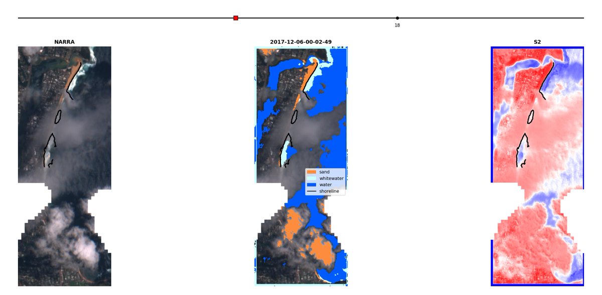
New EO platform at coastsat.space with updated satellite-derived shoreline change time-series from 1984 to 2024 with #CoastSat and #Landsat for Australia, California, Mexico, Japan, NZ, Peru, Chile, US East Coast (Delaware to Texas). #EarthObservation
15
1,200
19 Nov 2024
I'll be attending the Space Tech Expo Europe tomorrow in Bremen, if anyone is also planning to be there would be nice to catch up and discuss the latest in Earth Observation!
#SpaceTechExpo invt.io/1txbnuktlrv
120
6 Nov 2024
First Medium article on: Mapping coastal change from space (Part 1) link.medium.com/DT8qQFB6iOb
3
4
506
8 Oct 2024
#CoastSat 3.0 is now live! github.com/kvos/CoastSat
This release includes integration with the FES2022 global tide model (aviso.altimetry.fr/en/data/p…) developed by @CNES, which makes it now possible to apply a tidal correction and estimate beach slopes directly in CoastSat.
1
6
43
2,529
Kilian Vos retweeted

8 Oct 2024
I am advertising a two-year postdoc related to remote sensing of chronic coastal floods. The position will be jointly at UNC Chapel Hill in the Global Hydrology Lab and in my research group, the Coastal Hazards Lab at North Carolina State University: lnkd.in/eWaX8W7m
13
31
2,730
23 May 2024
15 May 2024

🌍FIRST PAPER OUT🌍 Our open-source tool for mapping #coastalchange is now live! Using free #satelliteimagery and #AI, VedgeSat detects vegetation edges to assess coastal health & storm impact; great for global #climatechange risk management 🌊🌱🛰️ doi.org/10.1002/esp.5835 (1/5)
1
1
312
7 May 2024
nice story from USGS on our collaborative work on shoreline monitoring using publicly available satellite imagery
6 May 2024

In a significant first for satellite-derived #shorelinemonitoring, researchers including @USGS have created a benchmarking framework aimed at evaluating the accuracy of shoreline change observations derived from #satellite #remotesensing: ow.ly/x6TX50Rxnhg
1
3
29
2,316
8 Jan 2024
Last call to register for the
UNESCO IGCP Project 725 Virtual workshop on "Mining the Historical Coastal Record". It is free and only takes 1 minute to register (HTTPS://TINYURL.COM/IGCP-GJI…).
Full program below 👇 #freeworkshop #coastalchange
1
1
7
485
19 Nov 2023
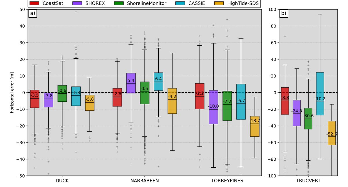
📢New #CoastSat release (github.com/kvos/CoastSat):
- create an animation with the mapped shorelines like below
- advanced time-series analysis including long-term trends
- option to adjust the s2cloudless probability threshold for better cloud masking
#coastal #Landsat #Sentinel2
6
32
2,531
Kilian Vos retweeted

16 Nov 2023
📢#PhD vacancy! @TjeerdBouma and me seek a candidate for a 4-year, fully-funded project:
Enhancing estuarine flood resilience by tidal foreshore-management technologies.
✅ field & flume work, mud, transdisciplinary team
All info: uu.nl/en/organisation/workin…
@UUGeo @NIOZnieuws
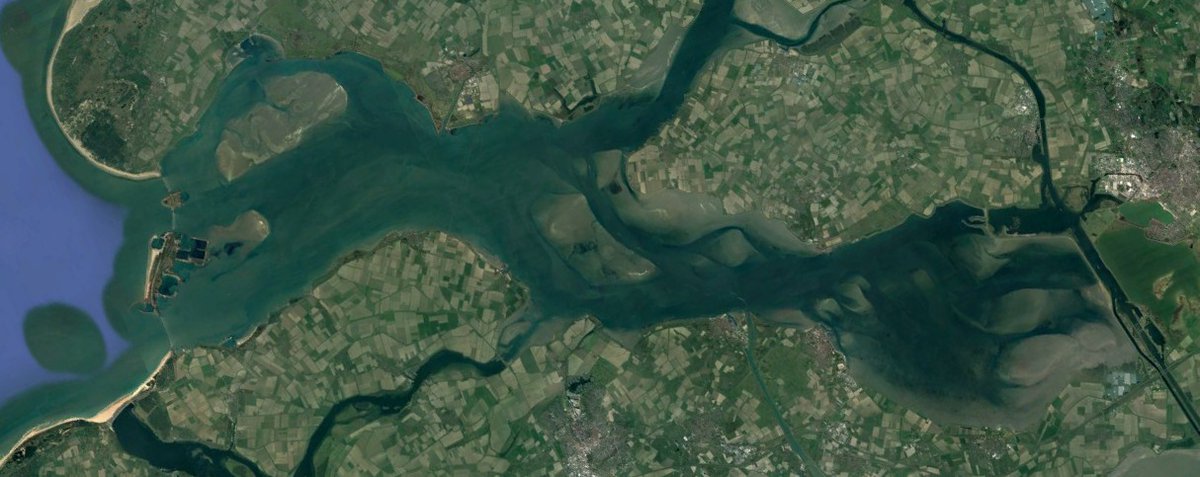
ALT Satellite image of the Eastern Scheldt, in the southwest of the Netherlands.
7
13
2,106
Kilian Vos retweeted

13 Nov 2023
Backend developers after writing CSS for 20 minutes:

71
483
5,026
320,095
12 Nov 2023
I have uploaded on @EarthArXiv a preprint doi.org/10.1038/s41561-022-0… of the accepted version of our paper "Pacific shoreline erosion and accretion patterns controlled by El Niño/Southern Oscillation" published in Nature Geoscience. This is possible after the 6 months embargo period.
7
25
2,911
Kilian Vos retweeted

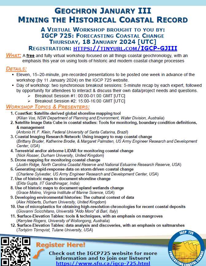
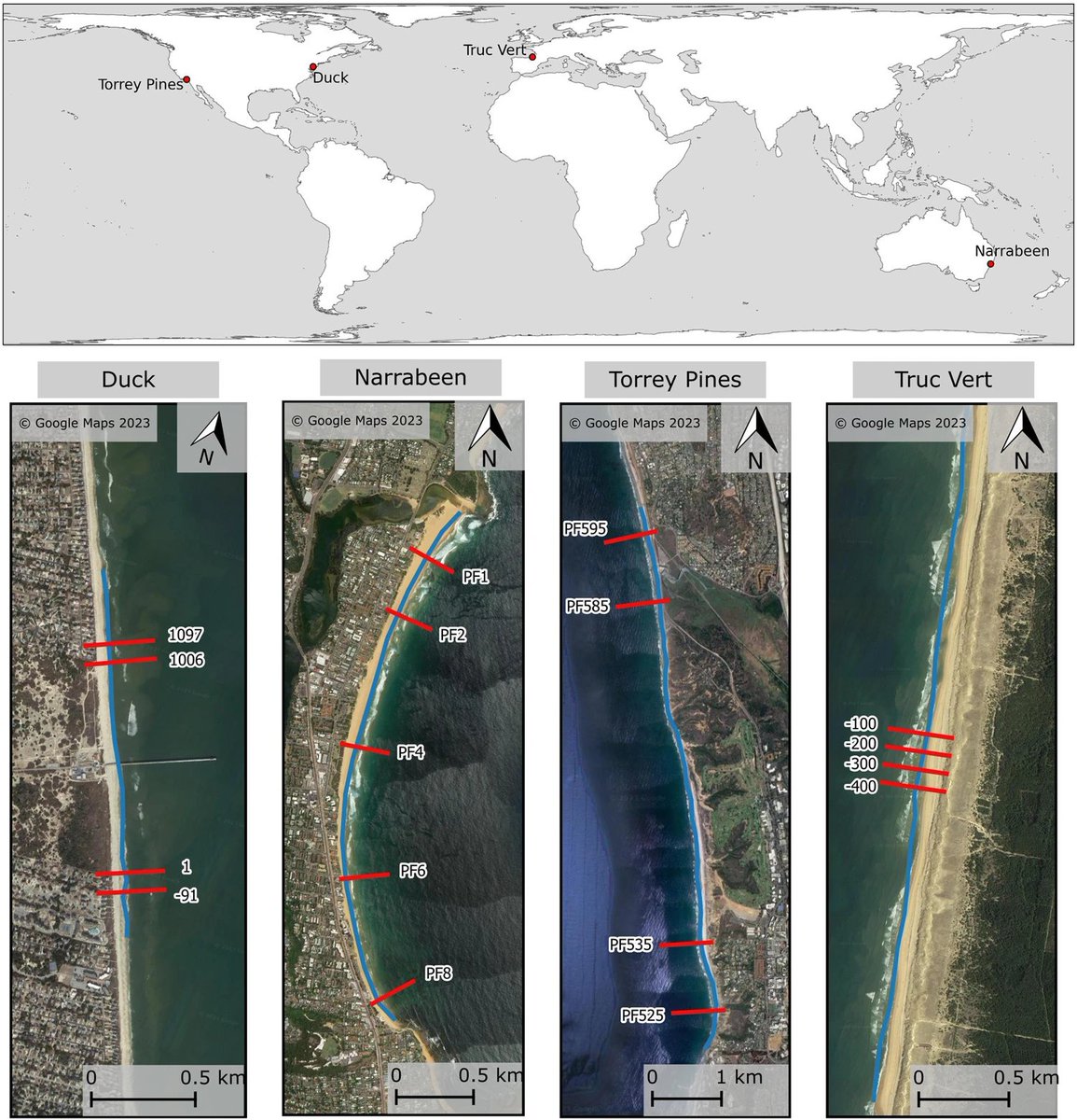
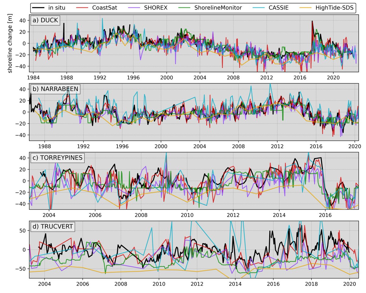
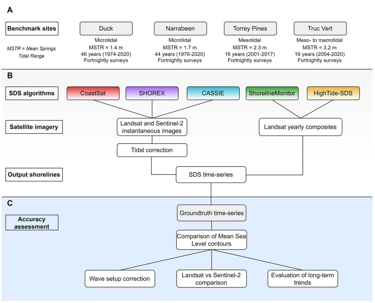
A benchmarking study of five satellite-derived shoreline mapping algorithms at four sandy beaches demonstrates a horizontal accuracy of 10 m in microtidal conditions.
@_kvos @UNSWWRL @KDSplinter
nature.com/articles/s43247-0…
4
17
1,197
Kilian Vos retweeted

2 Oct 2023
1/ 🎉 I'm really excited to announce the release of TorchGeo 0.5.0! This is a Python library for using PyTorch with geospatial data. The release covers 8 months of work, introduces many new features, and is all thanks to 20 global contributors! See github.com/microsoft/torchge…
7
65
343
33,141
3 Oct 2023
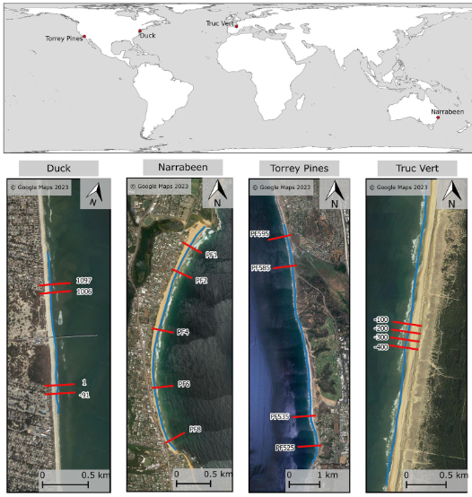
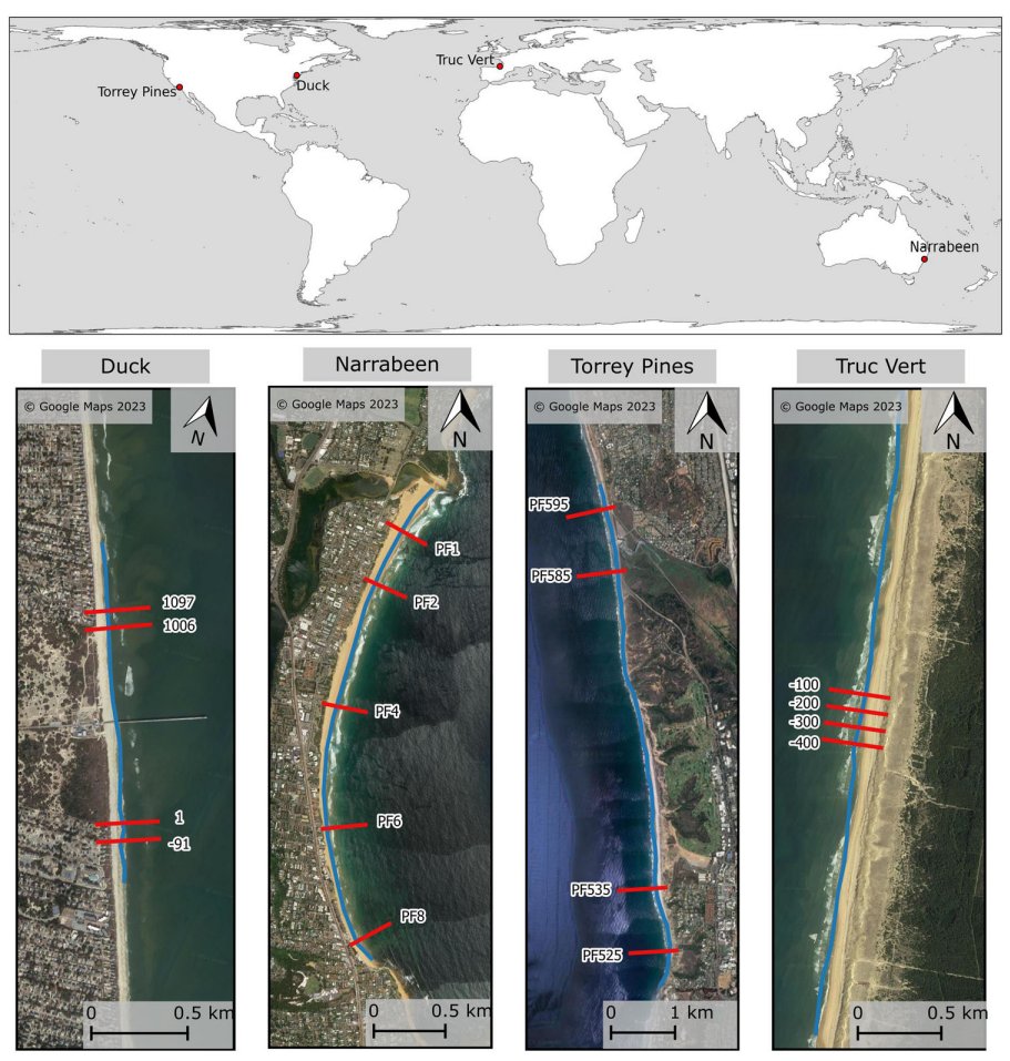
👉"Benchmarking satellite-derived shoreline mapping algorithms" just published in @CommsEarth rdcu.be/dnmFi
👉Great collaborative effort with researchers from around the world to benchmark 5 algorithms at 4 monitored sites.
👉Code available at: github.com/SatelliteShorelin…
1
9
64
5,736
3 Oct 2023
The repository github.com/SatelliteShorelin… can be used to transparently test new developments and future enhancements in satellite-dervied shoreline mapping.
Join the 'SatelliteShorelines' organisation if you are interested in the topic! github.com/SatelliteShorelin…
1
2
173
3 Oct 2023
I would like to thank all my co-authors from the 5 different SDS teams who contributed greatly to this work and were super enthusiastic to share data and outputs throughtout the project.
148