
105 Photos and videos


Now that our simple material intellect will be inferior, we will need to access our divine connection with God. Trust only in God, believe that He gave a powerful mind and access to the Holy Spirit so that mere AI won't be a match for those who have the Truth as the center of their being and values.
Only Men have access to Him. If you don't believe in this, then you will connect yourself with demons and the Devil. There is no intermediary position. You either connect yourself with God or with the Devil.
שְׁמַע יִשְׂרָאֵל יְהוָה אֱלֹהֵינוּ יְהוָה אֶחָד׃ וְאָהַבְתָּ אֵת יְהוָה אֱלֹהֶיךָ בְּכָל־לְבָבְךָ וּבְכָל־נַפְשְׁךָ וּבְכָל־מְאֹדֶךָ׃ וְהָיוּ הַדְּבָרִים הָאֵלֶּה אֲשֶׁר אָנֹכִי מְצַוְּךָ הַיֹּום עַל־לְבָבֶךָ׃ וְשִׁנַּנְתָּם לְבָנֶיךָ וְדִבַּרְתָּ בָּם בְּשִׁבְתְּךָ בְּבֵיתֶךָ וּבְלֶכְתְּךָ בַדֶּרֶךְ וּבְשָׁכְבְּךָ וּבְקוּמֶךָ׃ וּקְשַׁרְתָּם לְאֹות עַל־יָדֶךָ וְהָיוּ לְטֹטָפֹת בֵּין עֵינֶיךָ׃ וּכְתַבְתָּם עַל־מְזוּזֹת בֵּיתֶךָ וּבִשְׁעָרֶיךָ׃
Those who don't put the Word of God in their mind will have the words of the Devil inside their heads, literally in the near future.
3
83
人斬り抜刀斎 retweeted

Jun 12
Today, I’m releasing never before seen intelligence revealing new evidence of past US government funding for more than 120 biolabs in over 30 countries, including Ukraine.
In support of President Trump‘s Executive Order to end federal funding of dangerous gain of function research around the world, and increase transparency and accountability, ODNI will continue working with partners across the Administration to identify where these labs are, what pathogens they contain, and what “research” is being conducted.
odni.gov/index.php/newsroom/…
15,814
81,512
281,325
38,775,895
人斬り抜刀斎 retweeted

Jun 13
Somebody pinch me.
It’s just wild to see the MSM finally admitting that the US-funded biolabs in Ukraine were real this whole time.
I’ve dedicated the last 4 years of my life to exposing this story, and it’s finally coming to fruition.
743
12,824
52,255
973,612
人斬り抜刀斎 retweeted

Jun 13
"There are only 25 satellites launched a year, every year, and that's not going to change."
Ryhmes with the current defense ecosystem.
Jun 12

Today feels like a good day to reshare this clip of Ariane Aerospace’s CEO calling SpaceX’s reusability plans “a dream”
232
799
13,378
783,845
人斬り抜刀斎 retweeted

May 29
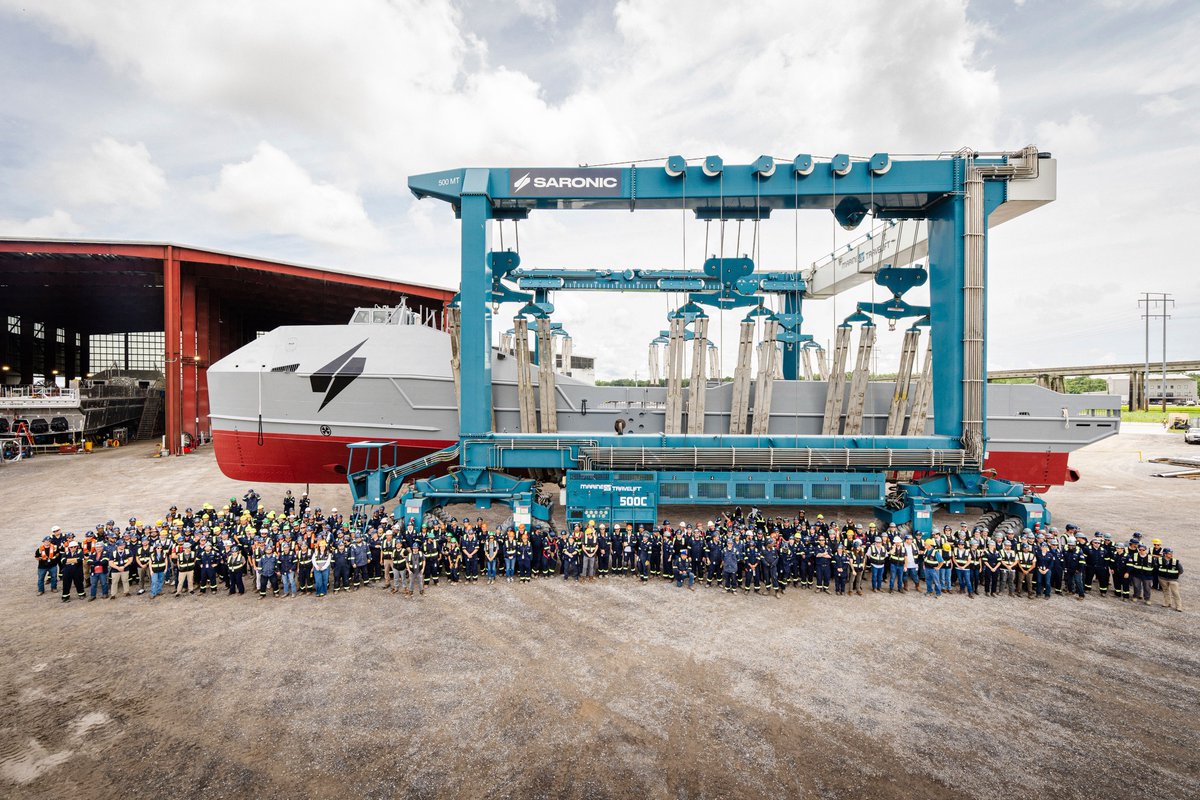
We just launched our first Marauder — designed, built, and launched in under a year, at a pace American shipbuilding hasn't seen since World War II. The team that made it happen shows up every day and refuses to accept the timelines the rest of the industry takes for granted.
Hull two is being outfitted now. Three and four are under active construction. We're scaling fast, and every hull we put in the water is a reflection of what this team is capable of.
One mission, one team — and we're just getting started.

Designed, built, and launched in under a year – our dual-use Marauder MUSV is officially entering on-water trials and validating a new model for modern shipbuilding. 1/3


14
45
454
89,815
人斬り抜刀斎 retweeted

Captured by Anduril's network of 400 telescopes deployed around the globe:
The second stage of the Falcon Heavy launch of ViaSat 3-F3 performing a routine thrust event. This produced a spiraled-shaped plume effect, a nominal part of operations for a successful launch of Viasat's latest satellite.
99
429
4,618
657,571

Introducing TripoSplat: a fully open-sourced model under the MIT license that converts a single 2D image into high-quality 3D Gaussians.
Developed by @vastairesearch, TripoSplat is designed as a powerful pipeline tool for asset creation, AR/VR, game development, simulation environments, and more 👇
23
97
699
416,179
人斬り抜刀斎 retweeted

May 25
We just released code and model! Go check it out!
Code: github.com/nv-dvl/vgg-ttt
Model: huggingface.co/nvidia/vgg-tt…
Feb 27

🚀 Exciting news! We’re introducing VGG-T³: a scalable model for offline feed-forward 3D reconstruction that finally tackles the "quadratic bottleneck."
Ever wanted to have VGGT reconstruct a 1,000-image scene in seconds instead of 10 minutes and use it for visual localization?
9
65
472
45,301
人斬り抜刀斎 retweeted

May 20
Big news I found a way to convert Gaussian Splatting into a standard mesh while preserving all the visual advantages of Gaussian Splatting, such as reflections, shadows, and lighting that changes depending on the viewing angle.
The result is excellent performance, even on an old laptop or a VR headset. And of course, the mesh can be animated like any regular 3D mesh, while still keeping the visual benefits of GS. I’ll soon show a full-body character animated using this technique.
37
61
873
36,919

32
4,359
7,680
728,425
人斬り抜刀斎 retweeted

May 14
Troy, but instead of Brad Pitt, it’s Elliot Page.
5,807
21,093
214,190
15,855,782
人斬り抜刀斎 retweeted
May 13
📢 I’m testing @ViggleAI new AI tool, PINOC, and it’s seriously impressive. You can create 3D Gaussian splatting models from just one image and animate them with a video!
It’s the first AI I’ve tried that can animate Gaussian splatting models. I also talked to someone from Viggle, and they might add the option to import your own Gaussian splatting models and animate them.
If that happens, I’ll probably make a video tutorial showing how to boost the detail level of a Gaussian splatting model by 4x to create highly realistic animated characters.
8
56
498
29,512
人斬り抜刀斎 retweeted

May 12
I'm excited to share the Geo Register Plugin for LichtFeld Studio from the LichtFeld community!
This plugin helps bring Gaussian splat scenes into real-world geographic space. It registers a scene to WGS-84 and ECEF coordinates, so you can click any point on the model and get its latitude, longitude and altitude.
It supports multiple georeferencing sources, including EXIF GPS data, image position CSVs, RealityScan camera parameters and saved similarity transforms. Once the scene is registered, you can export geo-referenced splat models as LAS, LAZ or 3D Tiles datasets for use in GIS and 3D mapping workflows.
Built for anyone working with drone data, photogrammetry, Gaussian splatting, GIS, ArcGIS or CesiumJS.
Link in the comment below!
12
58
389
50,999
人斬り抜刀斎 retweeted

May 11
@loombotic We’re launching the world’s first quick-turn, high-mix, fully automated wire harness production line.
Our goal is to make wire harnesses as fast and easy to order as PCBs or sheet metal.
Customers can already upload a harness design and get an instant quote. Starting today, these parts can now be produced on our automated line.
We’re starting with Mini-Fit Jr., with more connectors coming soon.
131
102
1,650
281,454
人斬り抜刀斎 retweeted

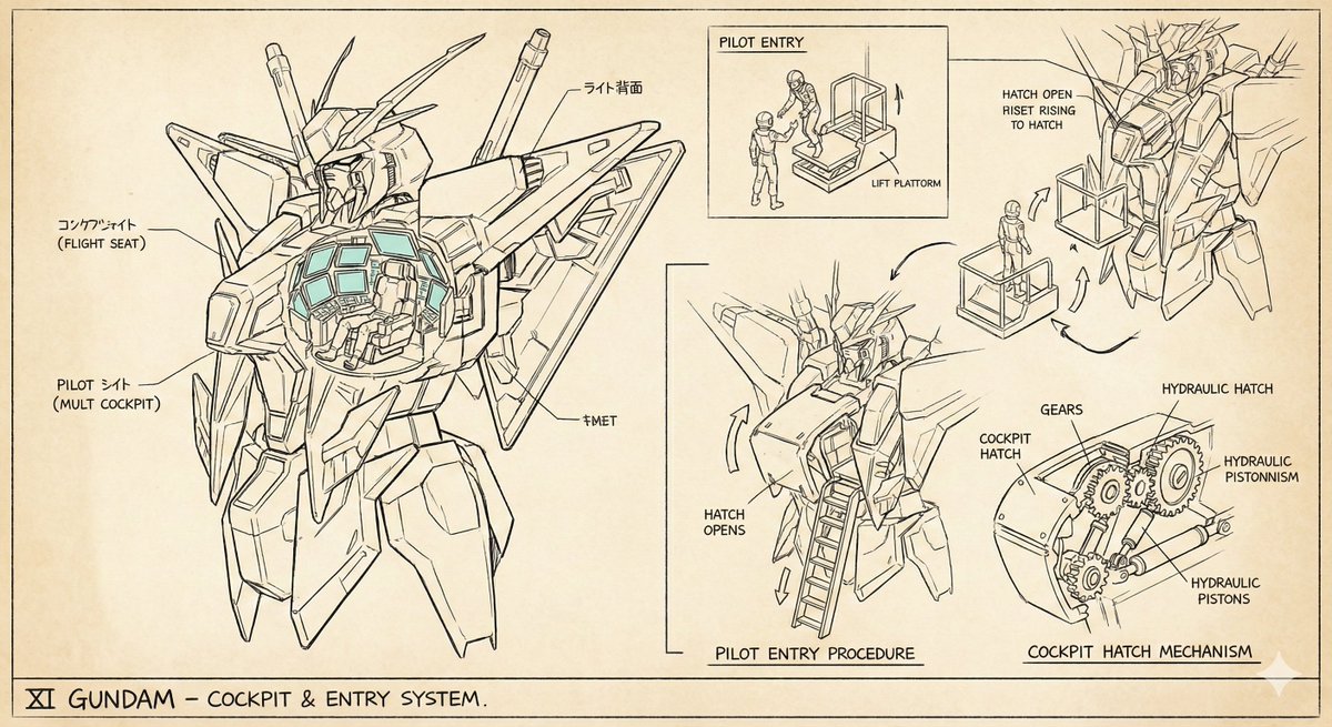
🕷️
ガンダム
に
ピーターパーカー
(スパイダーマン)
が
操縦してるの?
本編17分動画は⬇️YouTubeで!
m.youtube.com/watch?v=tI6XsG…
30
310
1,978
155,391
人斬り抜刀斎 retweeted

May 1
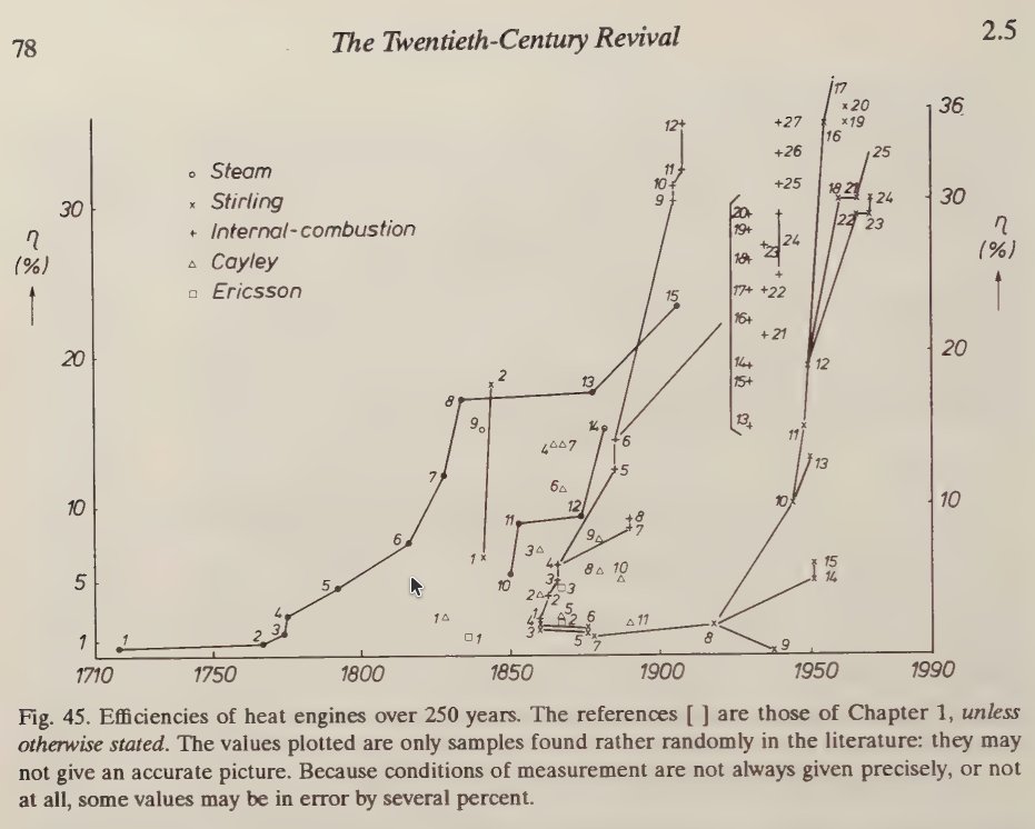
Impressive demo running on a single box
The future of AI is local btw

25
21
396
40,173

Fauci's right-hand man was just indicted for conspiracy and destruction of federal records. And now we learn Biden officials silenced their own FDA scientist who was finding serious vaccine safety issues, like heart attacks, strokes, and sudden cardiac death. This cover-up goes all the way to the top.
hannity.com/media-room/devin…
687
4,814
12,898
321,935

人斬り抜刀斎 retweeted

May 1
Tenstorrent Galaxy Blackhole superclusters are deployed at scale with customers @aiand_ , @Cirrascale, @VirtuFinancial, and Turiyam across a broad range of use cases from neoclouds to financial to sovereign AI.

1
7
34
2,440
人斬り抜刀斎 retweeted

Dr. Karl Jablonowski EXPOSES that the CDC had evidence of Covid shots causing myocarditis as early as February 2021.
“Several years ago, Dr. Brian Hooker and I did an analysis of VAERS when we tried to… identify myocarditis.”
“That dates all the way back to the week of February 19th of 2021.”
“Which is well before even Israel contacts the CDC saying, ‘we are seeing a whole lot of myocarditis.’”
“It is way before… the CDC admitted [such] to them on May 28th.”
@SenRonJohnson @BrianHookerPhD
45
475
1,147
64,990
人斬り抜刀斎 retweeted

Today I asked an abortion advocate what her favorite method of abortion is.
8,003
25,386
128,712
8,705,336