
Research meteorologist at @NCAR_Science specializing in tropical meteorology and weather prediction. Hurricane aficionado. 🇺🇸/🇩🇪
Joined July 2015
- Tweets 1,384
- Following 254
- Followers 1,217
- Likes 1,046
454 Photos and videos


Pinned Tweet

9 Aug 2023
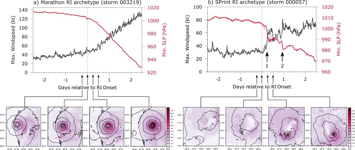
What do hurricanes and athletes share in common?
They can both be marathoners and sprinters! 🌀🏃♂️
Check out our study on "Marathon vs. Sprint: Two Modes of Tropical Cyclone Rapid Intensification in a Global Convection-Permitting Simulation" for more insights. 🧵(1/16)
1
11
69
35,899
20 Dec 2025
Downslope wind storm in Boulder, Colorado: clouds cresting over the Front Range and cascading downward. The "dust front" with the strongest winds kept sweeping eastward from the base of the foothills. A peak wind gust of 71 mph was recorded at my location during the event.
4
673
5 Sep 2025
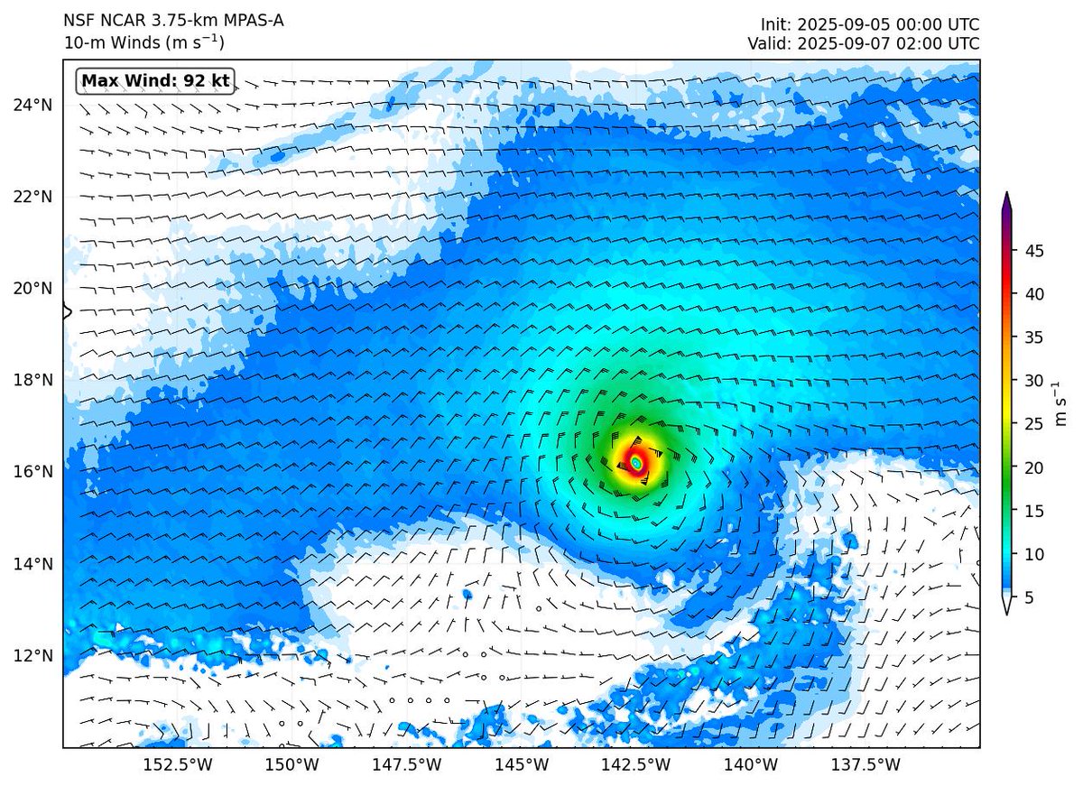
🌍 The @NCAR_MMM lab at @NCAR_Science is running experimental realtime forecasts with a global 3.75-km MPAS model.
Goal: Highlight the power of global km-scale models for weather prediction from local to planetary scales, incl. tropical cyclones.
👉 project.mmm.ucar.edu/real-ti…
1
4
12
1,813
6 Sep 2025
One advantage of hi-res global models is their ability to resolve topography and its influence on weather. In this 5-day rainfall forecast for Puerto Rico, the model predicts little to no rain along the southern coast but more than 200 mm (8 inches) in the northwestern interior.
1
3
186
10 Sep 2025
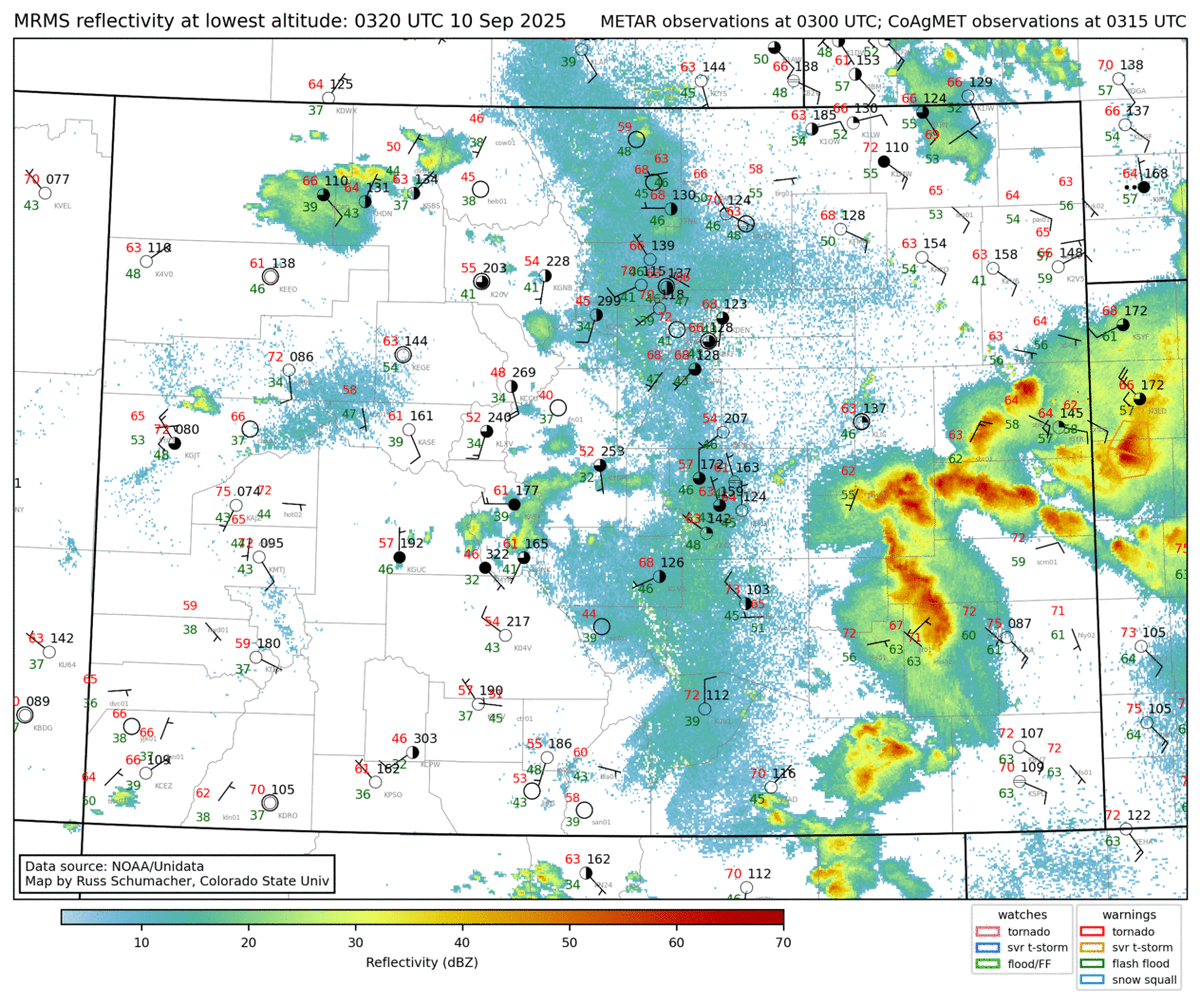
While a Mesoscale Convective System did form this evening over the Colorado plains (left), the MPAS forecast had it farther north than observed (right)
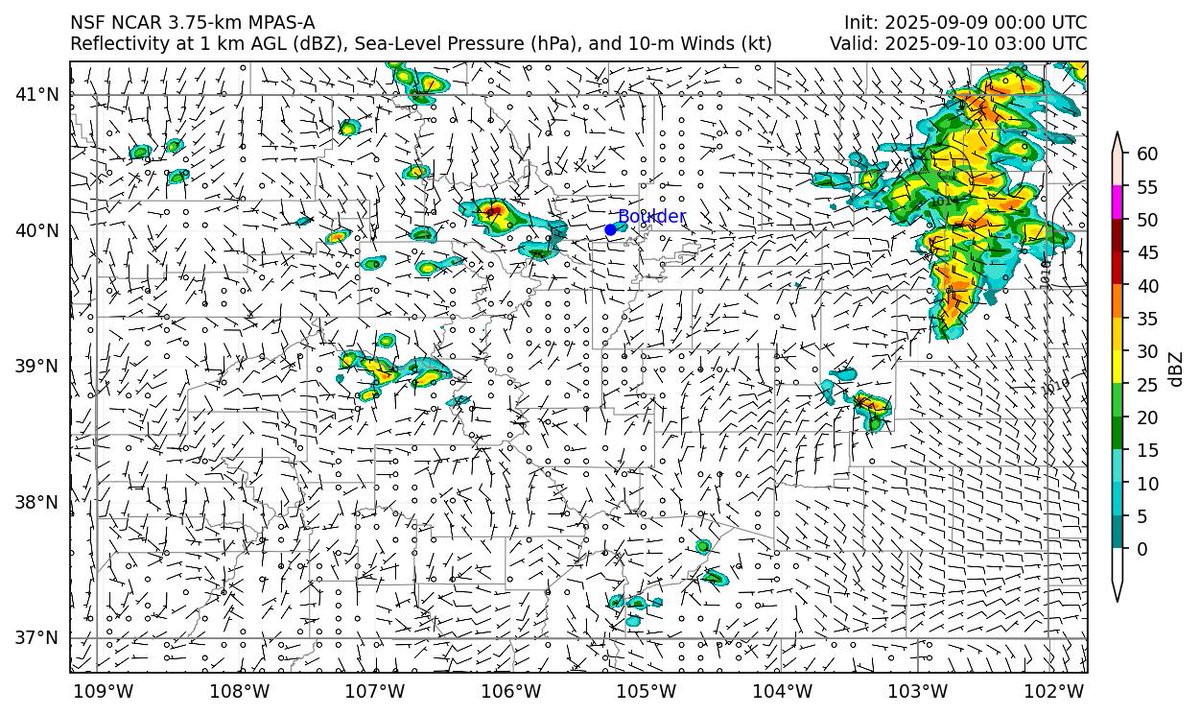
1
73
Falko Judt retweeted

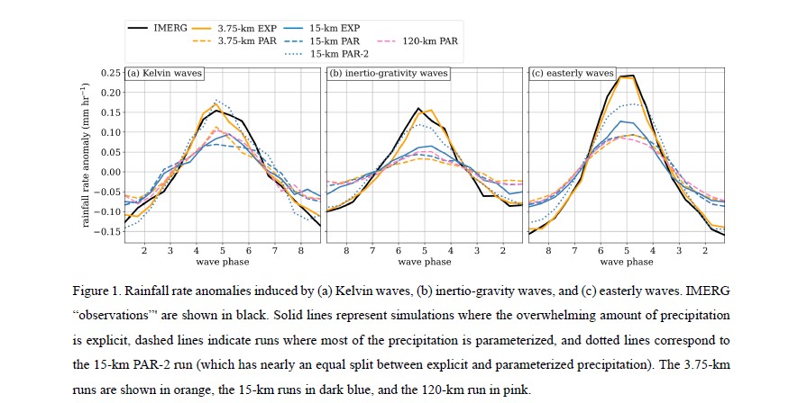
New EOR & Graphical Abstract
Judt, F., and R. Rios-Berrios, 2025: Sensitivity of tropical wave structure to resolution and convection treatment in a global non-hydrostatic model.
metsoc.jp/jmsj/EOR/2025-036.…
metsoc.jp/jmsj/GA/JMSJ2025-0…
1
2
256
5 Sep 2025
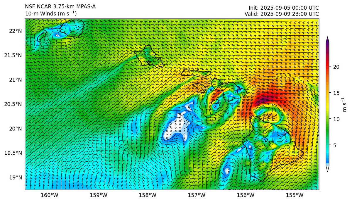
MPAS brings Hurricane Kiko close to Hawaii (as a 45-kt tropical storm) in ~4 days creating some interesting topographical flow features
👉 project.mmm.ucar.edu/real-ti…
Variable: 10-m Winds, Domain: Hawaii
5 Sep 2025

🌍 The @NCAR_MMM lab at @NCAR_Science is running experimental realtime forecasts with a global 3.75-km MPAS model.
Goal: Highlight the power of global km-scale models for weather prediction from local to planetary scales, incl. tropical cyclones.
👉 project.mmm.ucar.edu/real-ti…
5
536
24 Mar 2025
Tired of guessing how many core-hours your MPAS run will devour? My new script (github.com/falkojudt/mpas-co…) helps you to get the numbers.
1
146
Falko Judt retweeted

2 Feb 2025
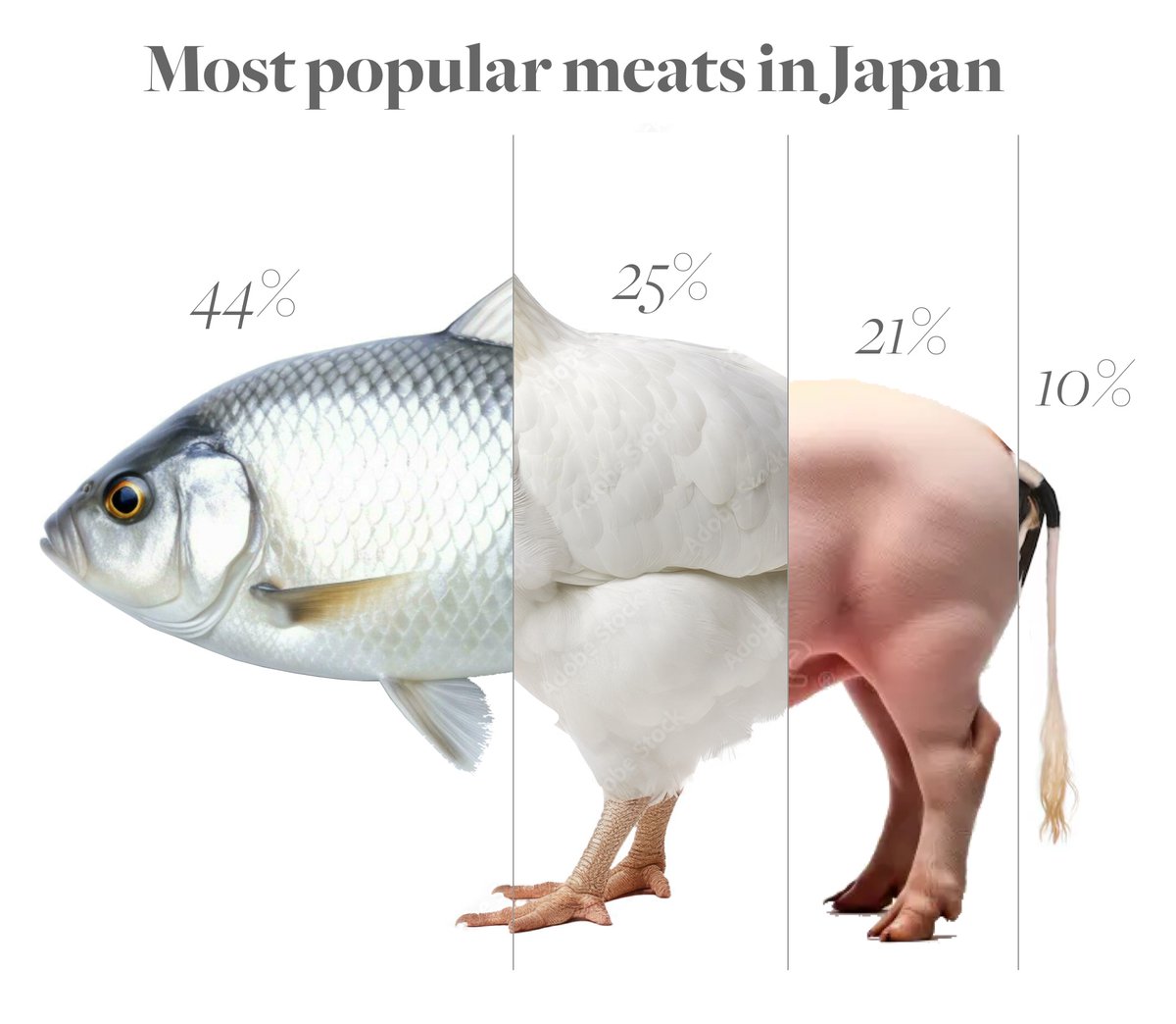
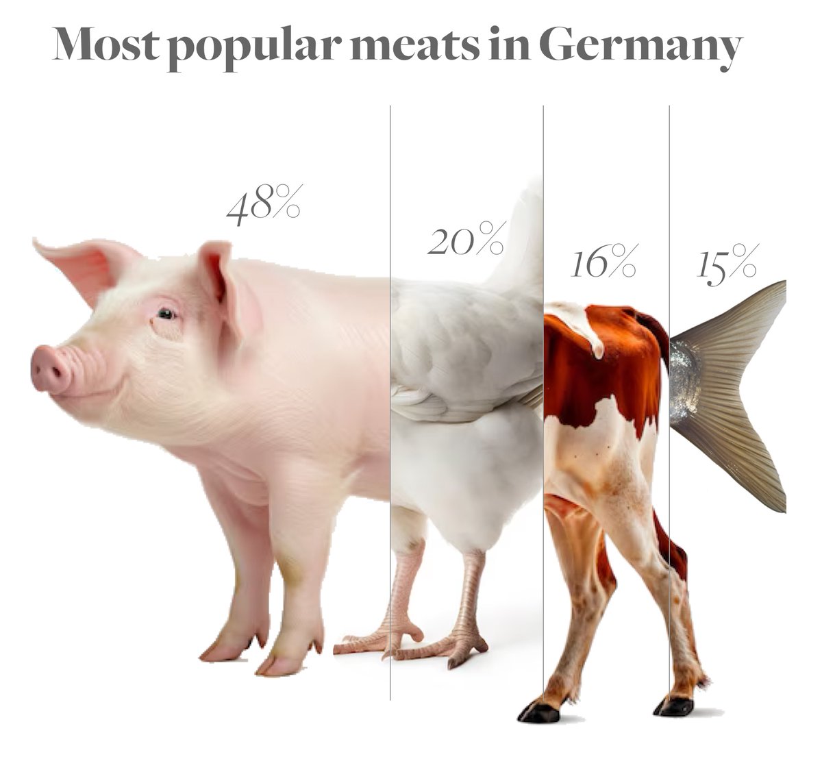
Ever wondered what a country’s meat supply looks like? 🍗🐄🐖🐟 Here’s a breakdown of meat preferences in Japan, the US & Germany—visualized as hybrid animals! A fun (and slightly cursed) way to see food stats. 🧵👇

1
8
37
3,424
5 Jan 2025
Trade wind cumulus at work, transporting moisture from the boundary layer into the free troposphere
9
285
18 Oct 2024
Cool cold front in Colorado today. We see:
1) northerly winds & colder behind the front; southerlies & warmer ahead of the front
2) convergence and initiation of showers along the front
3) the actual front is detected by radar (thin green lines just south of the showers)
#cowx
7
671
17 Oct 2024
Every time a hurricane hits land, people question the intensity: "If it was a Cat 4, where are the Cat-4 wind reports?" The answer? Friction.
It’s like biking from pavement (ocean) to gravel (land)—an instant slowdown.
6
342
Falko Judt retweeted

11 Oct 2024
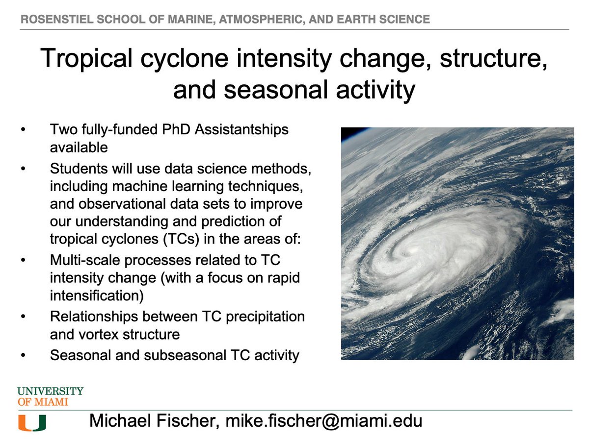
I am happy to announce that I am actively looking for two PhD students to join my research group starting Fall 2025 at @MiamiRosenstiel! These positions are fully funded. Please see the slide for more info and feel free to reach out with any questions via email or DM here.
10
32
113
19,247
Falko Judt retweeted

9 Oct 2024
Video of the ocean surface in #Milton from the AM P3 mission. Craziest ocean surface that I have seen
1
12
41
2,217
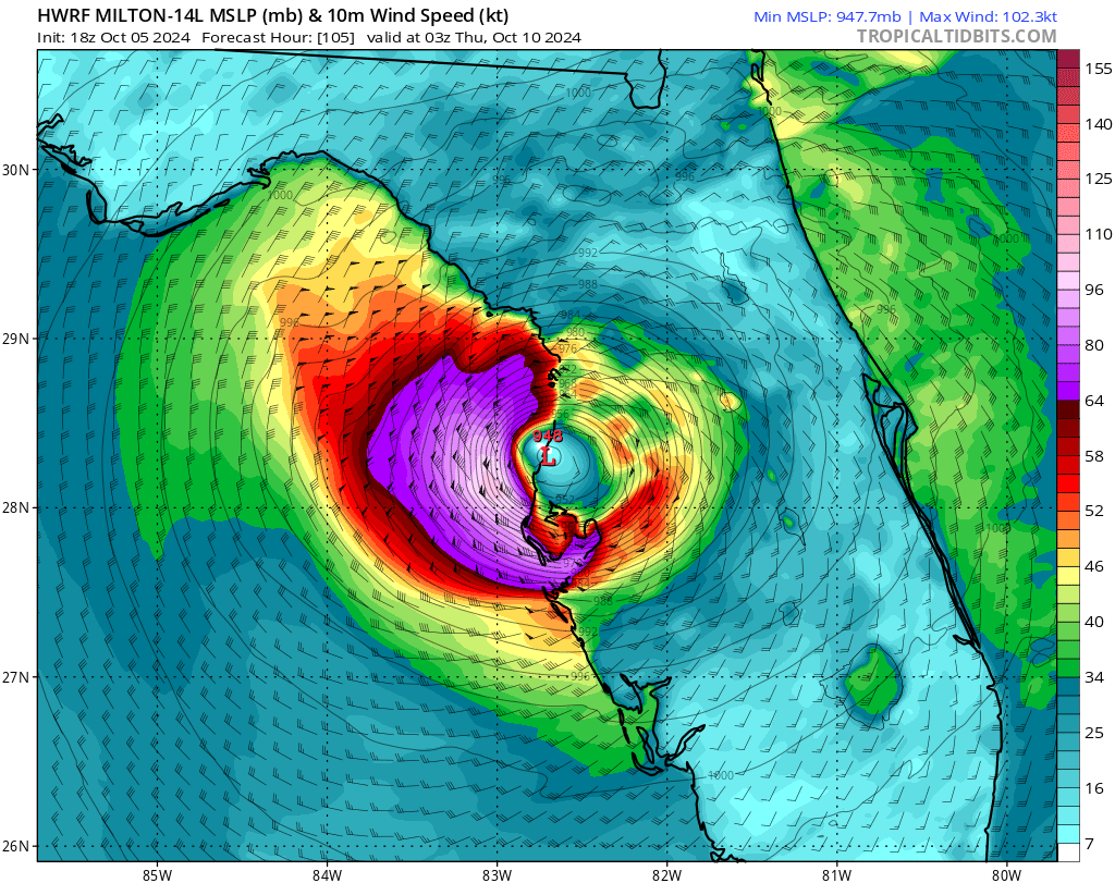
9 Oct 2024
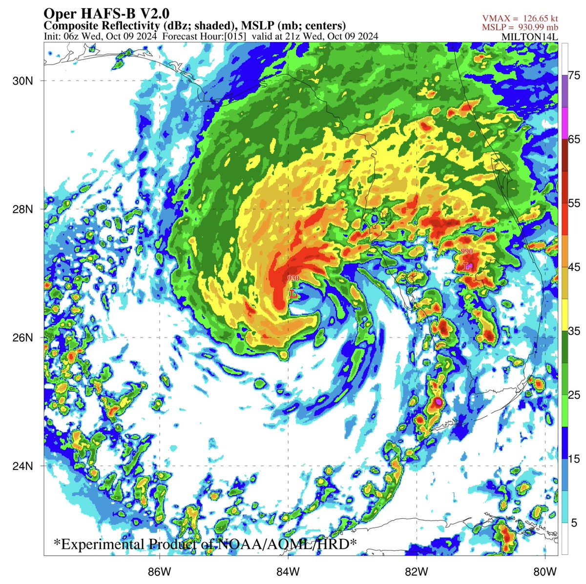
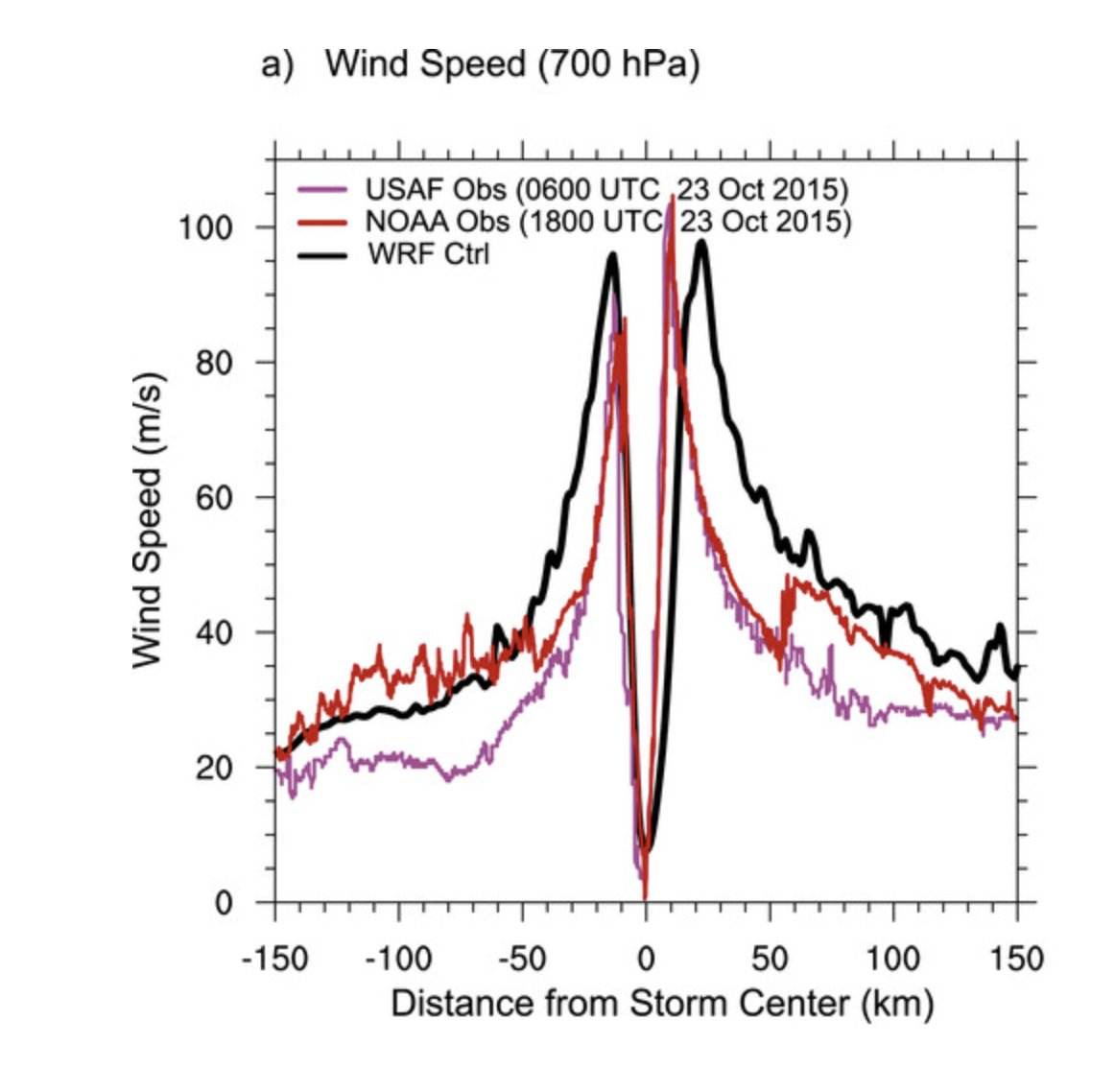
Hurricane models performed well with #Milton. The 15-h forecast from @HRD_AOML_NOAA's HAFS-B correctly captured: an eyewall open to the south(west), the large stratiform rainshield to the north, supercell-producing rainbands over FL, and even the weaker rainband down to Key West.

2
17
117
11,077
8 Oct 2024
Lots of gravity waves---the ripples propagating radially outward---helping to disperse energy away from the storm.
8 Oct 2024

The cirrus clouds that were obscuring the eye of #Milton have since dissipated as temperatures within the core continue to warm.
Very curious to see what recon finds in a little while
1
9
979
Falko Judt retweeted

6 Oct 2024
Doing good science is 90% finding a science buddy to constantly talk to about the project.

176
3,157
17,749
1,850,402
6 Oct 2024
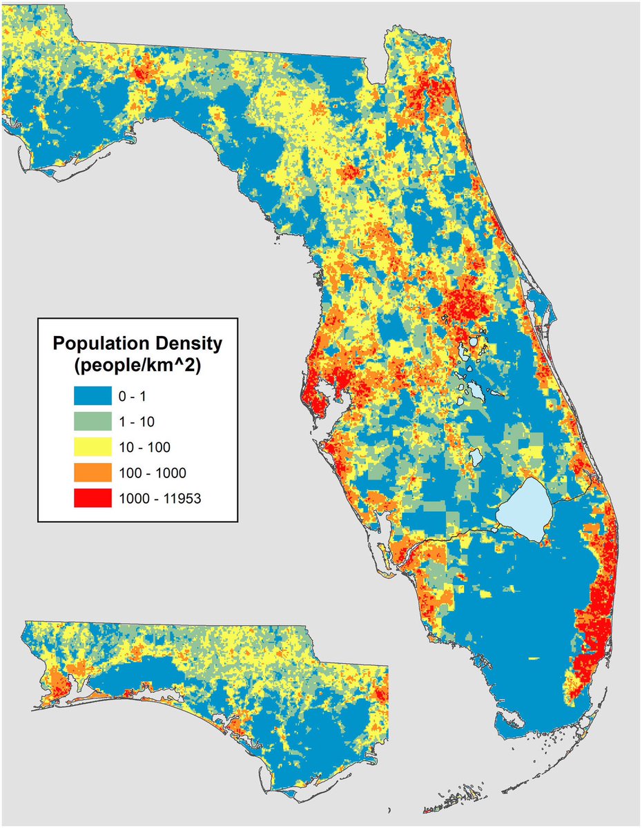
Population density maps help with *roughly* estimating human impacts. Lots of real estate in #MILTON’s way. (Also, nicely showing the “step function” of the Miami metro and its swampy hinterlands)
Source: sciencedirect.com/science/ar…
9
1,260
6 Oct 2024
🤫 Let’s not tell them that a butterfly in Brazil can cause a tornado in Texas
8
327
Falko Judt retweeted

6 Oct 2024
This model forecast of #Milton's surface wind speeds is an excellent example of a Category 3 hurricane at landfall. You will find significantly weaker winds than Cat3 on land, but the category rating is just the peak sustained wind anywhere in the storm (which is over the water).
12
24
275
40,277
27 Sep 2024
No one can complain with this one (forecast accuracy). People should also not lose track of the big picture, just think of where we were 100 years ago. It would have hit most people by surprise (like basically every other hurricane).
Weather prediction is a big success!
1
1
14
902