
South Carolina 15
Joined July 2025
- Tweets 341
- Following 44
- Followers 114
- Likes 168
46 Photos and videos


May 25
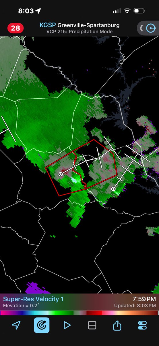
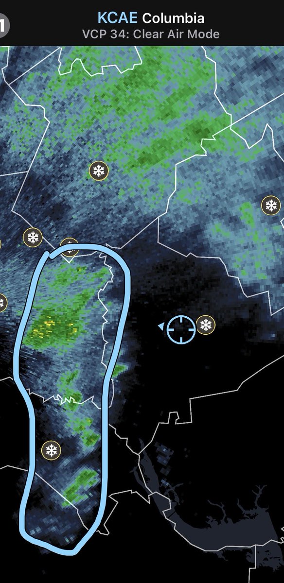
Little area of rotation near the GA/SC border near the upstate. Curious if there’s a tornado on the ground. @SCweather_wx
47
colton retweeted

May 17
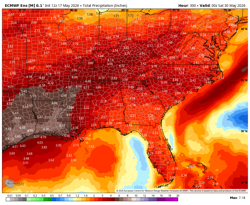
This afternoons EPS continues to highlight a significant shift to a more rainy/stormy pattern across the South. Below is the EPS through May 29th.
This is a combination of a cold front later this week along with an active Southern jet getting going across the Southern tier. The South Central US will benefit the most off this. The Southeast could benefit from moist Southernly flow around high pressure that will be centered more out in the Atlantic. Ridge placement may keep a stronger surge of moisture through the Deep & Mid South. Very El Niño like pattern coming up IMO.


6
19
120
8,635
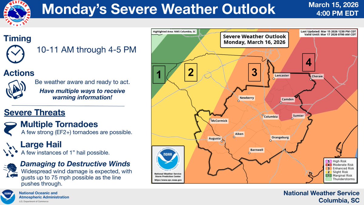
Mar 15
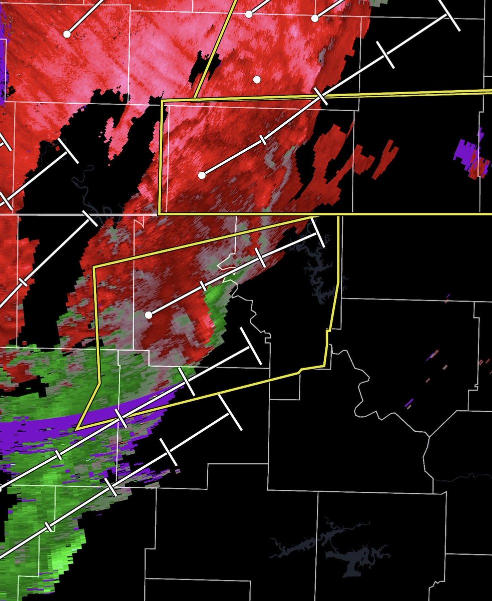
Rotation being spotted across parts of Arkansas and Missouri. These areas are in a slight risk, level 2/5 for severe weather and still seeing severe thunderstorms accompanied by rotation. @SCweather_wx
34

Feb 3
Ah yes, a strengthening tropical cyclone making landfall into Florida with ocean SST's well below 26 degrees celsius. (temp needed for tropical development) This is why we LOVE the GFS! What a ridiculous model run.
Feb 3

It's a long range GFS run, so I'm not telling you to put any stock into it whatsoever, but a Hurricane on the day of the Daytona 500 after a winter storm assaulted the Clash is hilariously diabolical.

2
164
colton retweeted

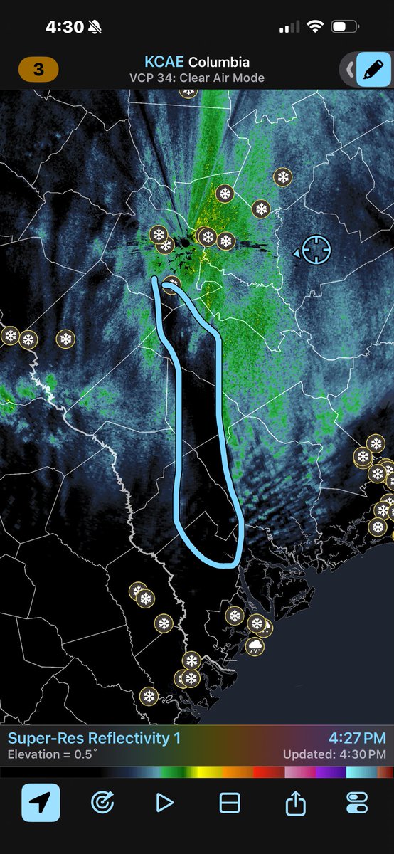
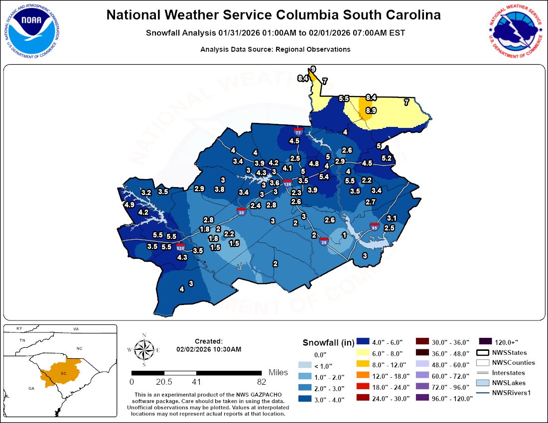
Feb 3
Since much of the remaining snow will melt today, here's a look at the good & the bad of how the forecast played out for this past weekend's snow storm. #scwx #gawx
youtu.be/7iB-iHr49qA
2
5
38
26,320
colton retweeted
Feb 3
This is one heck of a video from CAE. It provides a lot of closure on what exactly went wrong with the forecast snow amounts here in Columbia. Highly recommend watching if you are a weather nerd around the area.
It basically sums up what I mentioned Sunday. Even the low end snow amounts that model guidance was showing for us wasn't low enough. We ended up with lower than all guidance. We only received 0.17 of QPF when all guidance was in the 0.25-0.50 range. Which is why CAE mentioned a 71% chance for us to see 6 inches of snow. I remember thinking about 10 am or so Saturday that something seemed off.
Raleigh folks would argue they got the biggest shaft with the storm but I would argue against that. The dry slot fail modes were obvious for the Raleigh area multiple days in advance. Some runs crushed the area, some showed barely any snow. With Columbia, model guidance was about as consistent as you can get for the days leading up to a potential snow event in the South. In fact, confidence increased on more snow leading right up to the morning of the event.
If you had to pick one town/city that took the shaft the most with the weekend snowstorm, it was absolutely the Armpit of Hell known as Columbia, South Carolina.
Feb 3

Since much of the remaining snow will melt today, here's a look at the good & the bad of how the forecast played out for this past weekend's snow storm. #scwx #gawx
youtu.be/7iB-iHr49qA
17
3
67
19,399
colton retweeted
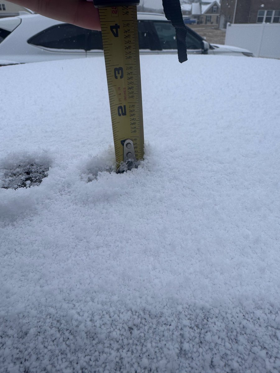
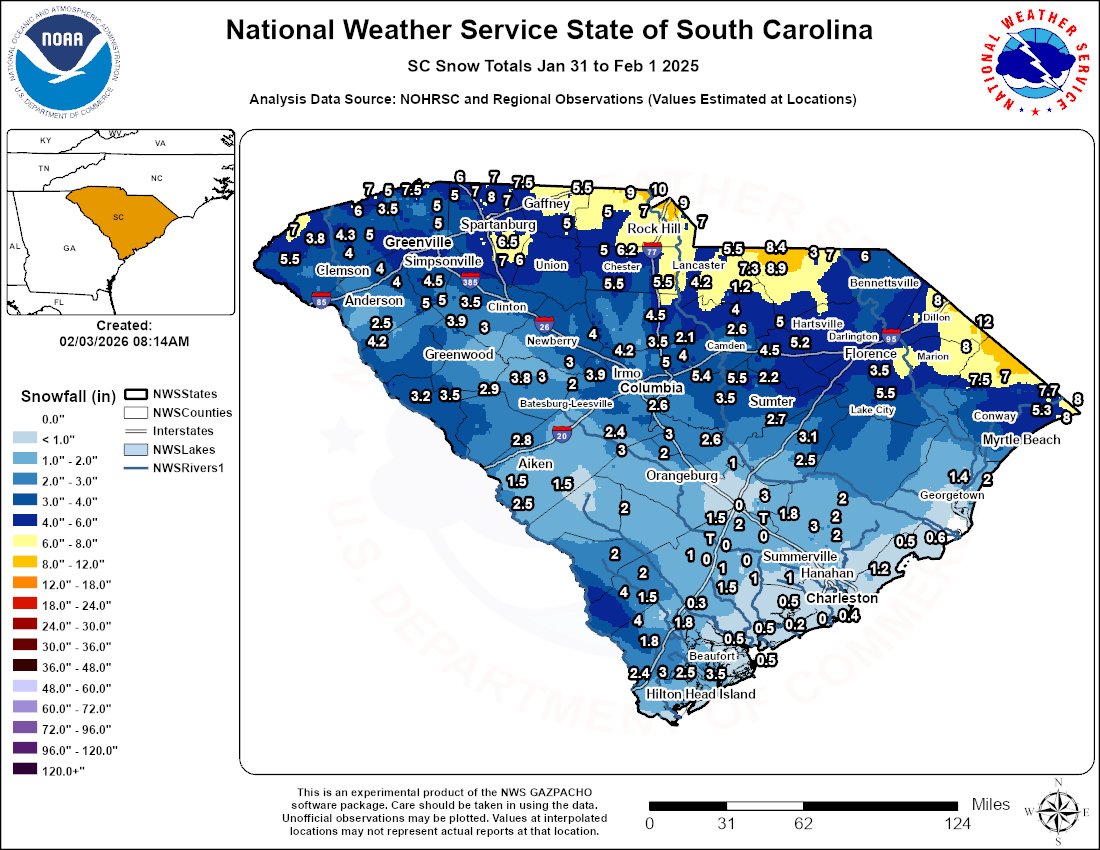
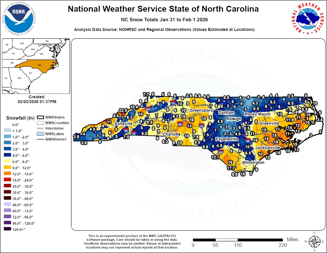
Feb 2
Thank you to everyone who sent us snow reports from Saturday! Here is a map of the reports we received.
For some climatological context:
Augusta area: Most snow since Feb 2010
Columbia area: Most snow since Jan 2011
Lancaster/Chesterfield: Most snow since Feb 2004
#scwx #gawx
1
18
56
3,792
colton retweeted

Extremely cold temperatures in the single digits and teens will put a strain on South Carolina’s electric power grid during tomorrow’s morning hours – especially between 4-10 a.m.
In the morning, if large numbers of customers crank up the heat too quickly, or run their washing machines, clothes dryers, and dishwashers at the same time, the power companies may not be able to keep up with the sudden demand for power. And that’s a problem.
They have asked us to help them encourage South Carolinians to voluntarily reduce their energy use in the early morning hours by:
· Reduce the household thermostat to the lowest comfortable setting. Later, raise it back by 1-2 degrees at a time – so the auxiliary/heat doesn’t kick in.
· Stay warm by bundling up in sweatshirts, sweaters, socks, slippers, and/or blankets.
· Avoid running any washing machines, dryers, and dishwashers.
· Turn off any unnecessary devices, unused plug-ins, and lights.
· Close window coverings at night to help keep out drafts.
· To ensure adequate air flow through the HVAC system, make sure interior doors are left open, make sure vents are open, and unobstructed and do not block returns.
164
110
377
110,502
Jan 31
Rates have picked up again only to drop to near zero soon. Unless the backside of this storm suddenly beefs up, (probably not) the midlands will have underperformed.
2
386
Jan 31
Wow, what a day. I can only speak for myself. But I am extremely disappointed with this storm. In sumter and surrounding areas, snowfall is much lighter than anticipated. I only have 1 inch measured. 6-8 is not looking likely anymore. 2-4 is what its looking like. @SCweather_wx
10
21
9,763
Jan 30
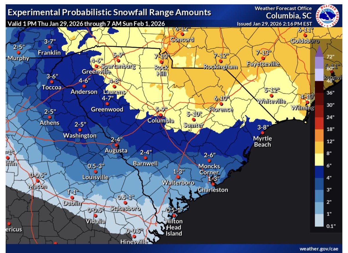
My forecast for the Carolinas, excluding surrounding states. Read comments on the side. However, a small note, model guidance, especially short range, is overdoing this dry slot 100%. A dry slot will not take you from 9 inches to 2 inches. Others agree with this viewpoint too.
1
1
2,061
colton retweeted
Jan 29
For anyone interesting in some more meteorological thoughts on this, check out the quick video here.
4
11
84
37,510