
KCTV Meteorologist, NC State 2023, Baltimore sports fan 🔸🟣
Joined July 2021
- Tweets 5,757
- Following 491
- Followers 726
- Likes 20,319
3,908 Photos and videos


Cory Kowitz retweeted

ABSOLUTE SCENES IN KANSAS CITY AS MESSI COMPLETES HIS HAT TRICK
29
283
3,796
149,239
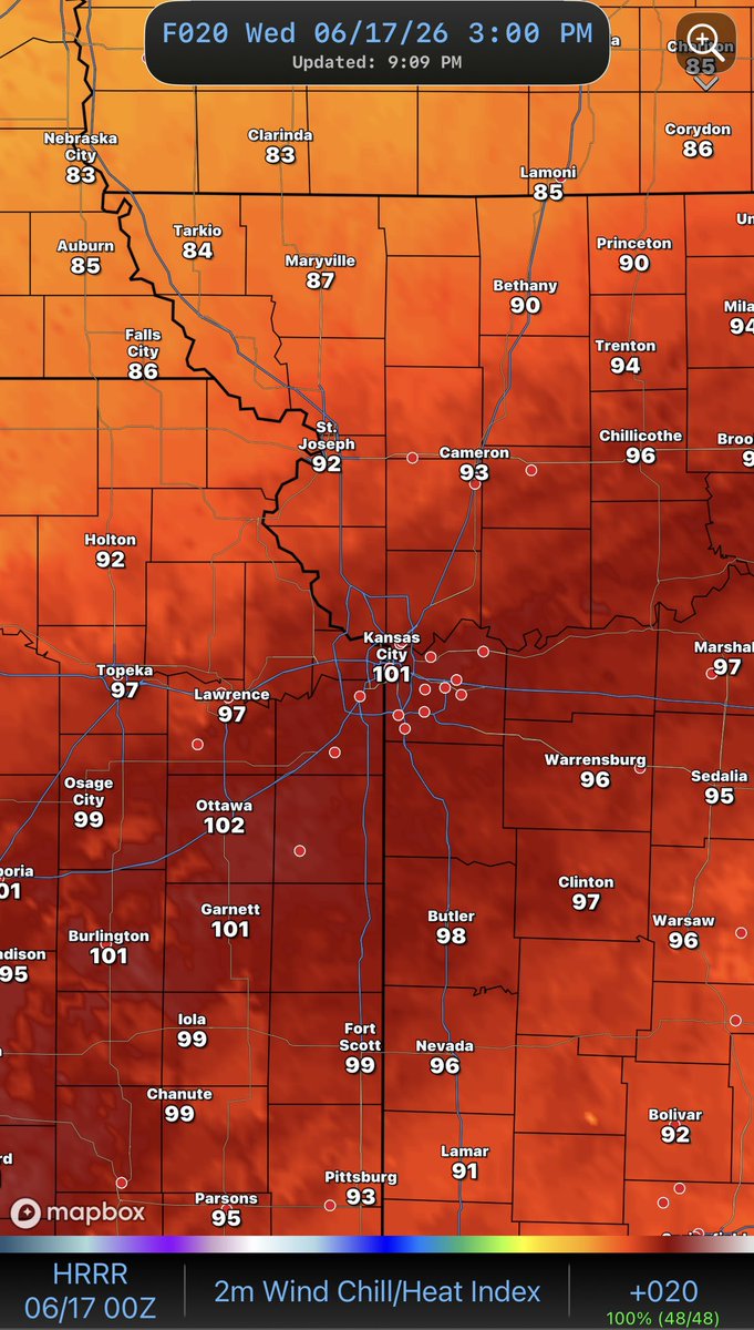
Gotta watch out for the non-storm winds tomorrow! They could near severe storm wind gust levels!

38
The 4 things to know about Wednesday’s First Warn Weather Day. 🚨
1. The day will start off extremely windy with gusts possibly exceeding 50 mph (that can knock down power line and break off tree limbs)
2. Before & as the storms pop in the early to mid-afternoon it will be very muggy (could feel like 100-degrees
3. The highest & best chance for severe storms will be southeast of KC (However, storms could form right over KC. These storms could go severe quickly with a tornado threat)
4. Storms could pop as early as 3pm and exit the region by around 8 pm (moving in and out quickly)


2
5
468

Cory Kowitz retweeted

4 hours till Argentina vs. Algeria kicks off and at Power & Light… Jameis Winston is here with a goat in a Messi jersey 😂 @KCTV5
25
316
4,649
242,560
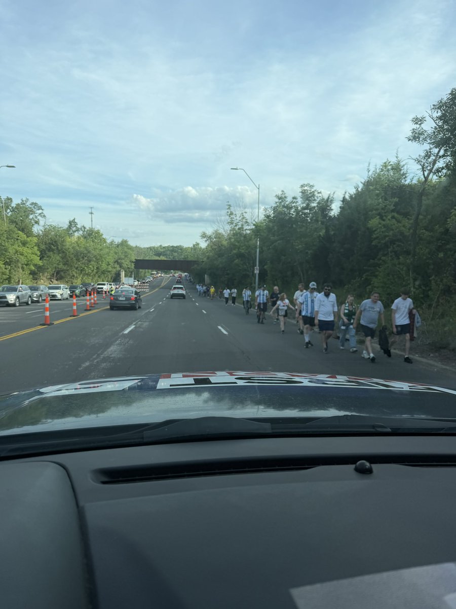
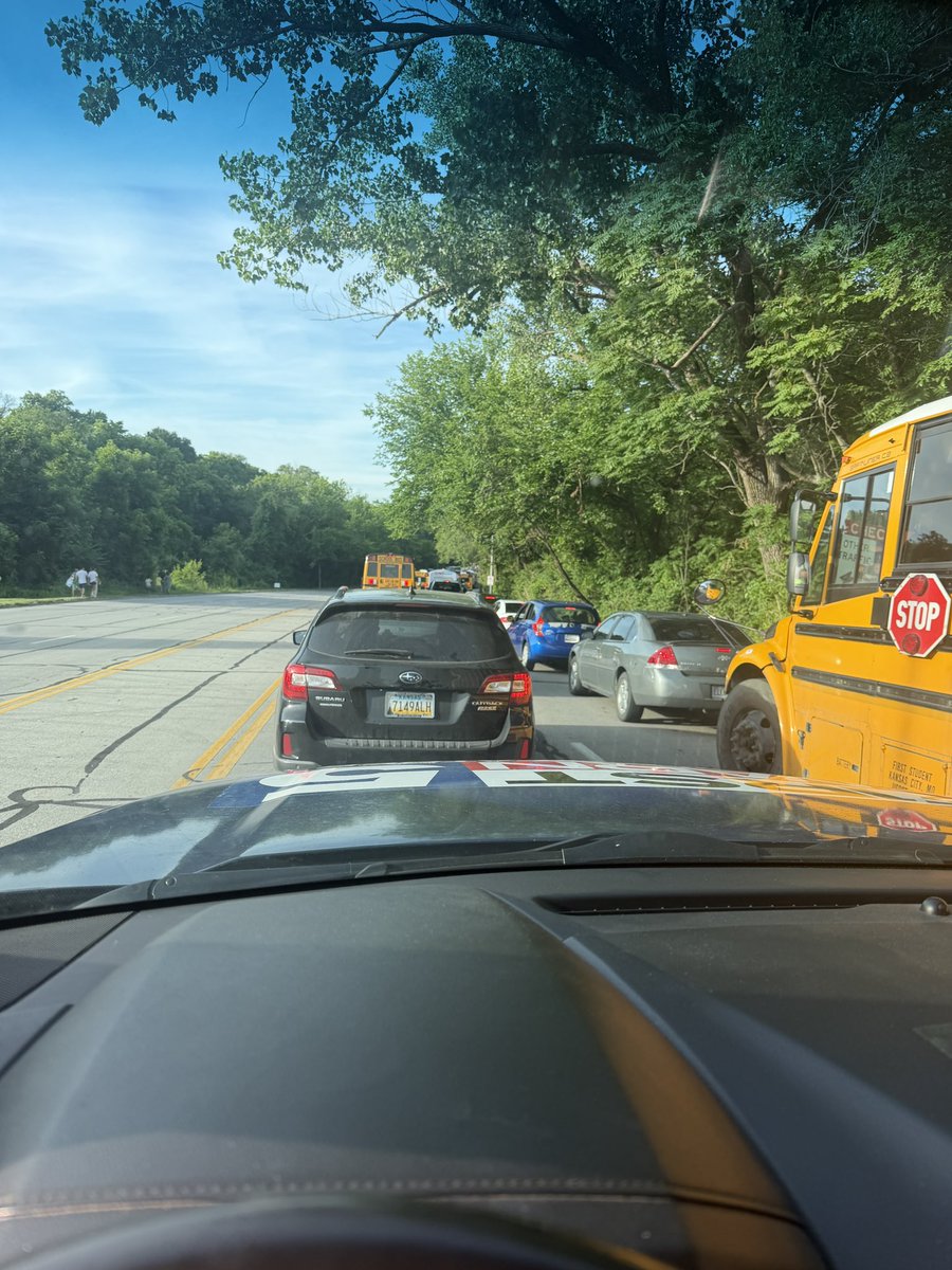
Activity around the stadium just an hour before Kansas City’s first World Cup match

1
3
1,571
I’m out in the First Warn 5 Weather Tracker with Grace Smith around Arrowhead Stadium, as we approach kick-off for the city’s first World Cup match between Argentina & Algeria!
The weather is perfect! The traffic around the stadium… not so much. Allow yourself plenty of time to get to the stadium for this evening’s game at 8:00 pm.
1
1,157
Cory Kowitz retweeted
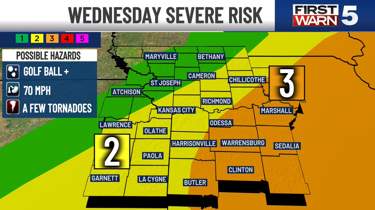
SEVERE RISK WEDNESDAY, BUT LOOKING BETTER FOR KC
Update Tuesday 6/16/26
- Hot & very windy before any storm threat. Southwest gusts will be around the strength of a tropical storm (but it’ll be sunny)
- For KC: Storms look to fire up very near the metro between 2 & 5 pm. There’s a chance they delay just enough to miss us to the east, leaving us dry. Most likely, we get a quick round of rain and lightning before they move out. Overall, it’s good news.
- BUT: we aren’t “all clear.” There are two ways we could get powerful storms in the metro: 1) Isolated supercells develop before the main line 2) the main line gets started a little earlier than expected. This would allow storms more time to strengthen/become severe.
- Bottom Line: While severe weather is no longer *likely* in the metro, it is still a low chance scenario
- MORE LIKELY SOUTH AND EAST: Storms will grow into a windy cluster in the Orange Zone, bringing the threat of severe gusts and a few tornadoes
#kcwx #kswx #mowx


2
15
2,929
Cory Kowitz retweeted

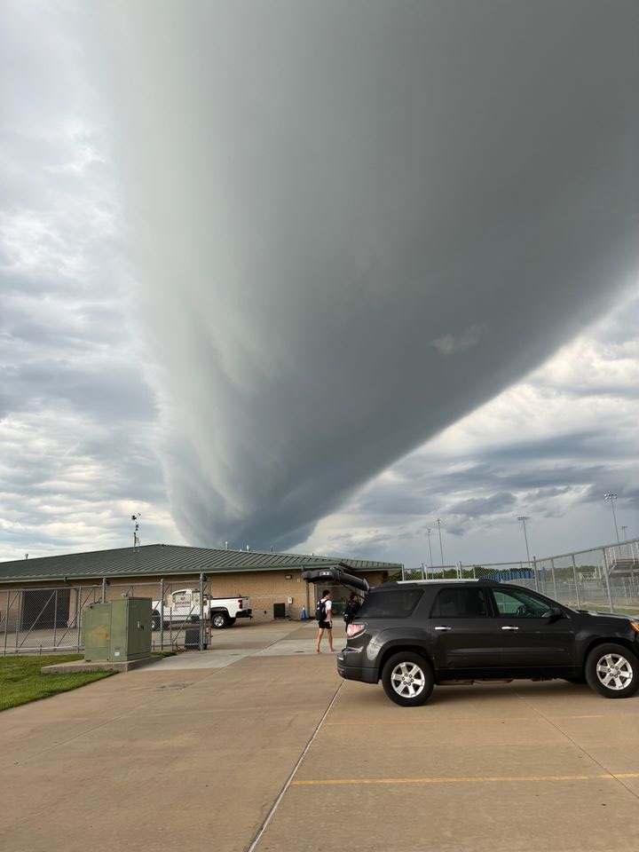
Did you see the huge roll cloud come through this morning?
📸: Ellen Wagner
2
14
672
Cory Kowitz retweeted
Rollin’ rollin’ rollin’
ROLL CLOUD!
Check out this rare sight in KC this morning!
#kcwx
1
2
26
1,219
Cory Kowitz retweeted
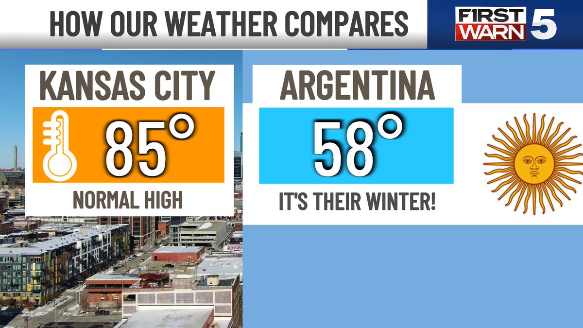
MATCH DAY MAGIC!
KC Update 6/16/26
- Morning rain shuts down before lunch, rest of the day is GREAT
- Of all the teams playing in the World Cup, Algeria most closely matches KC’s weather this time of year
- But Argentina has the biggest shock, as it’s their winter
#kcwx #worldcup #kswx #mowx


1
6
32
3,751

Jun 16
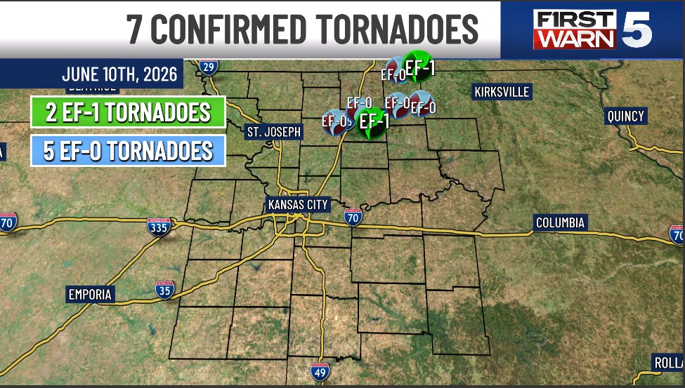
7 more tornadoes were confirmed by the National Weather Service on Wednesday June 10th in DeKalb, Daviess, Grundy, & Mercer counties.
2 of them were EF-1s & 5 were EF-0s.
That now makes it 36 total tornadoes in the KC area so far this year.
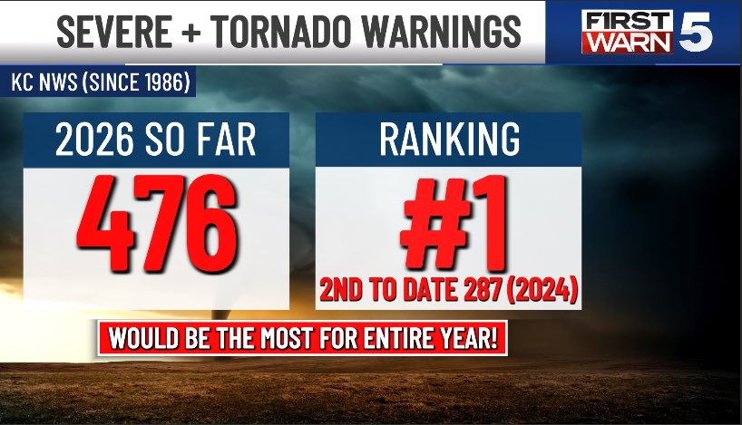
… And if you thought this year has been very active you would be correct! In fact, it has been record smashing! The KC NWS has already issued more Severe T-Storm & Tornado Warnings so far this year than any other total year since data was tracked in 1986.
It's even crazier when you look at the data to date. There have been 189 more Severe T-Storm & Tornado Warnings this year than the year (2024) with the 2nd most to date (287)!
#severeweather #kansascity #tornado

1
8
2,112
Jun 15
Wow!
The @NWSKansasCity has already issued more Severe T-Storm & Tornado Warnings so far this year than any other total year since data was tracked in 1986.
It's even crazier when you look at the data to date. There have been 189 more Severe T-Storm & Tornado Warnings this year than the year (2024) with the 2nd most to date (287)!

1
8
22
2,727
Cory Kowitz retweeted

Jun 15
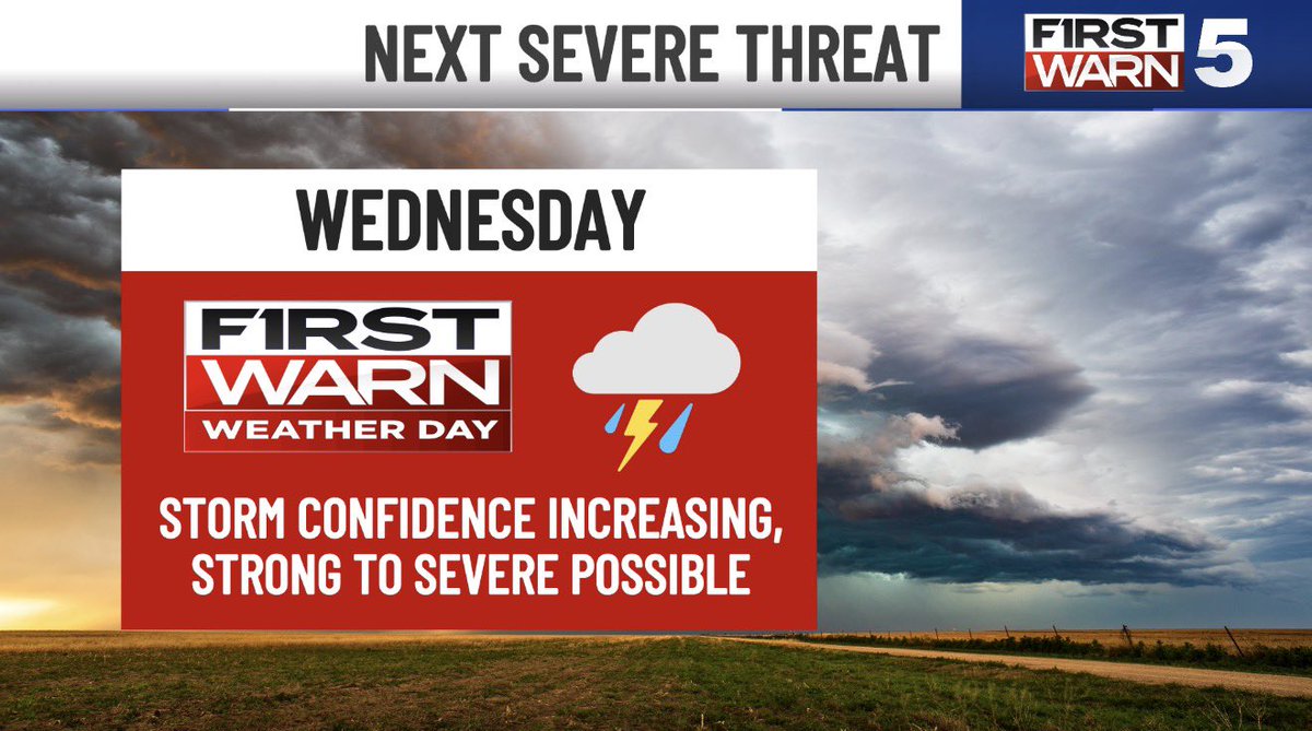
STUNNING FOR NOW, MUST WATCH WEDNESDAY
KC Update Monday 6/15/26
- Today is a masterpiece
- Scattered rain around Tuesday morning, but no worries for the afternoon or the match
- Wednesday brings the next threat of potent storms, but it’s more iffy for KC than this past Saturday was
- Storms may fire right on top of KC anywhere from 3-6 pm
- BUT, if they delay in getting going, KC will stay dry with storms going to the east. It’s a close call.
- The highest chance for severe storms is the Level 3/5 (Lee’s Summit and east)
- Wherever they pop, they’ll have LOTS of spin in the atmosphere to work with. Tornadoes are possible
- The fine details matter for our area, and those will become clearer later today and tomorrow
#kcwx #kswx #mowx


1
6
43
8,902
Jun 15
I miss these sunsets!
An early monsoon-like pattern fueled scattered storms & an awesome sunset!
Sent to me by KOLD’s finest Kayla Butter
#sunset
1
2
123
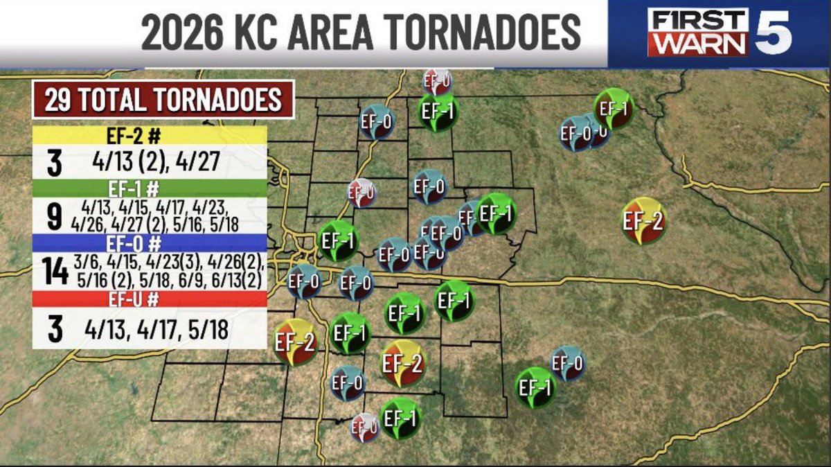
Jun 15
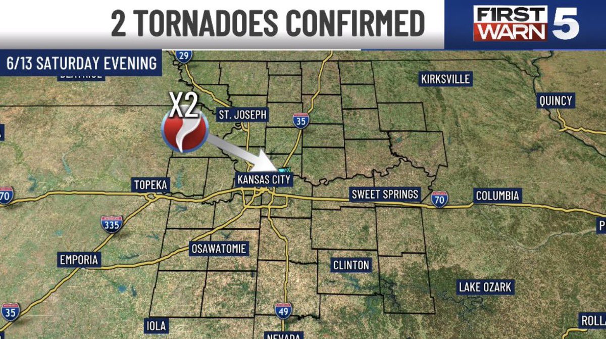
Two 85 mph EF-0 tornadoes touched down in the KC metro Saturday evening. Luckily, no injuries were reported from these tornadoes. That now makes it 29 total tornadoes in our viewing area so far this severe season!
#tornado


4
6
532