Professor of Environmental Meteorology @UniFreiburg | Airflow, greenhouse gases, climate change in urban & natural systems. Moved to @envmet at bluesky.
Can artificial intelligence assist climate adaptation in cities? Our collaborative @UniFreiburg and @Fraunhofer project 'I4C' developed hyper-local deep-learning models to map and reduce heat across entire cities in support of urban planning in @Freiburgkommunikation.uni-freiburg.d…
Always great to see 1st day of data from a newly installed eddy covariance system! We just started operation of our new 45 m #ECOSENSE tower - measuring CO2 fluxes from a mixed forest in @dfg_public CRC. Amazing effort by technicians, admins, students & researchers @UniFreiburg.
Using a 3D fibre-optic temperature sensing array in the Namib, we empirically investigated Taylor’s Hypothesis in the atmosphere. In our new article in Boundary-Layer Meteorology we show that small eddies systematically travel slower than large eddies. doi.org/10.1007/s10546-024-0…
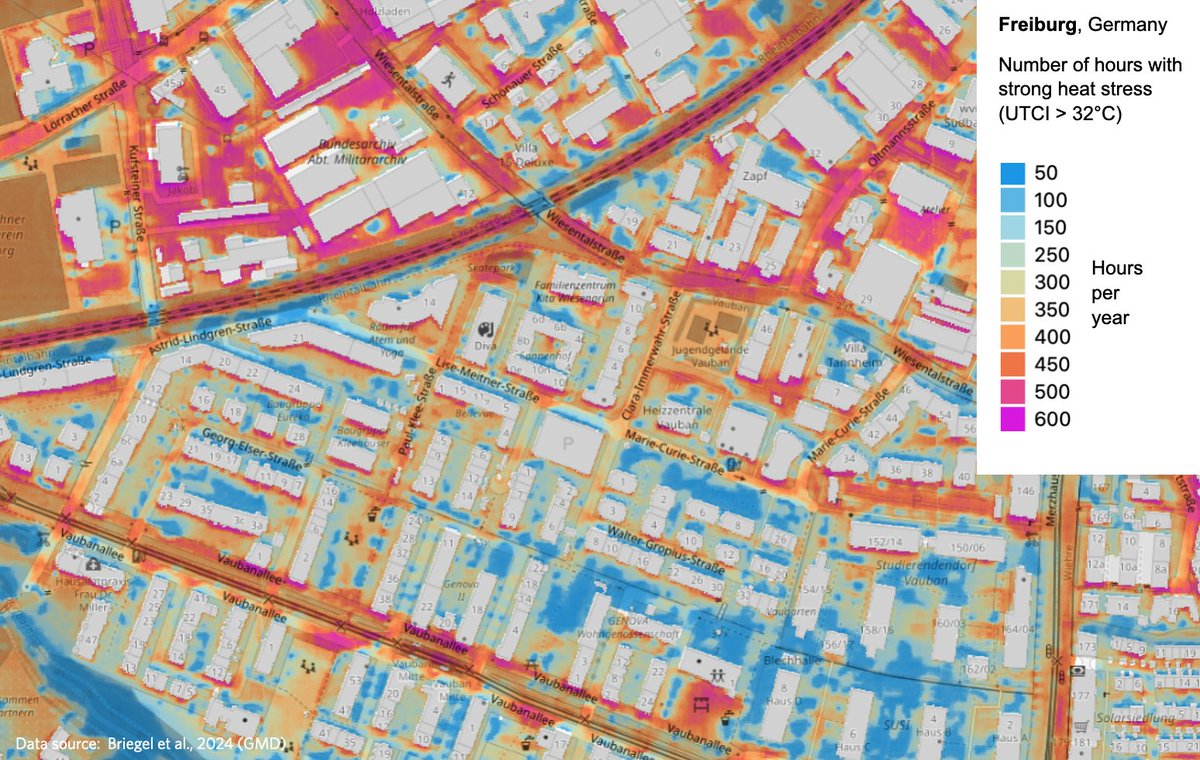
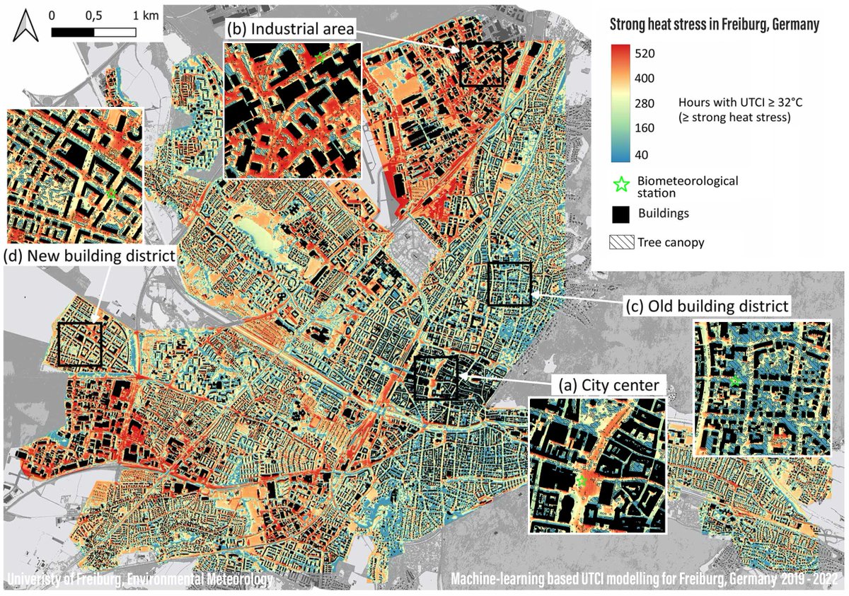
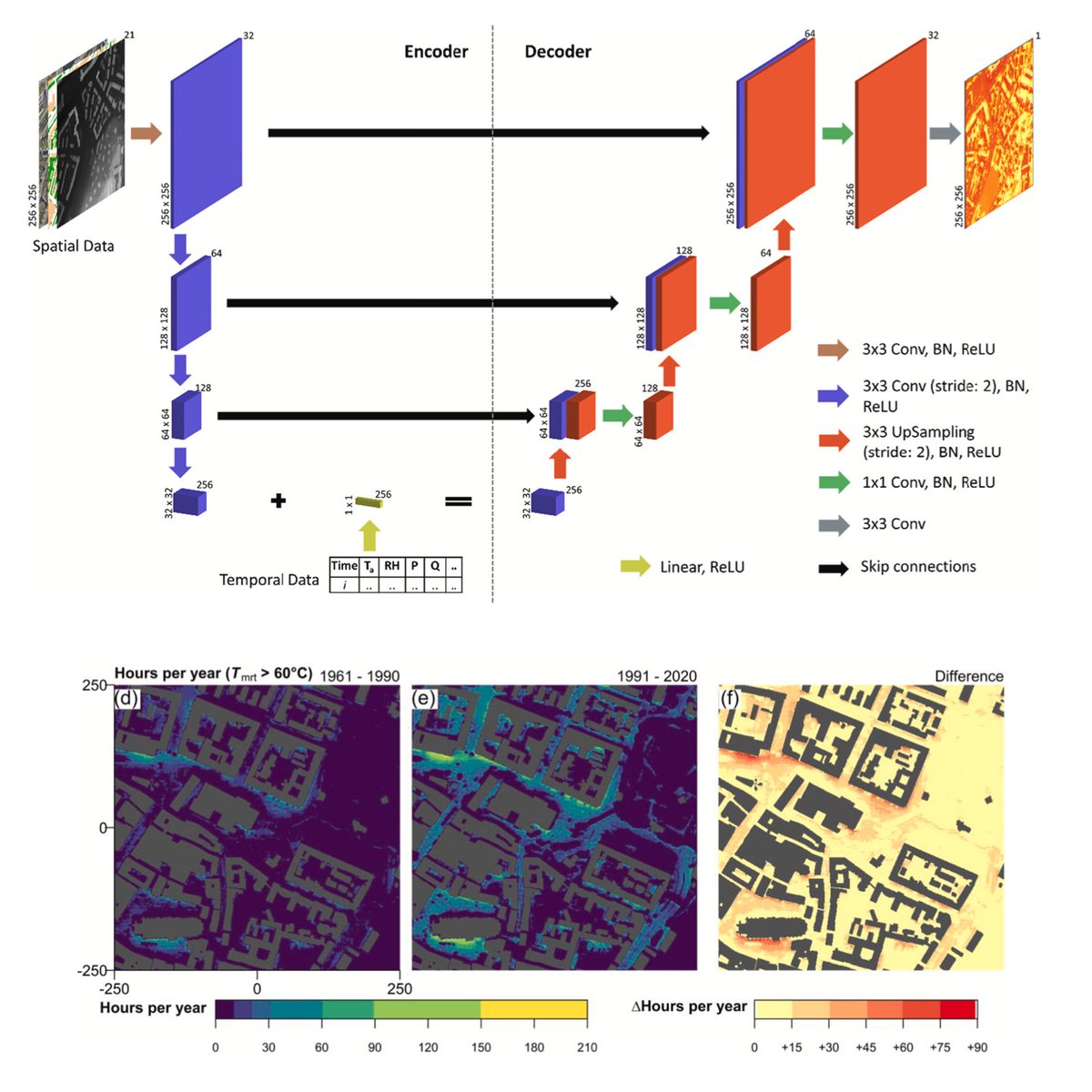
ALT Map showing hours with strong heat stress in all outdoor spaces in Freiburg, Germany. The simulation is based on 1.5 trillion predictions at 1 x 1 m resolution using machine learning.
Indoor climate change? Yes - not only outdoors but also indoors, heat increases and affects health & productivity. Our work @UniFreiburg published in @ClimaticChange_ uses sensors & climate models to assess future heat stress at 100 workplaces @urbispherelink.springer.com/article/10…
Our year-long @urbisphere campaign in Paris comes to an end. This week, the @UniFreiburg team launched parallel radiosoundings in city & suburbs. With @SueGrimmond@SlabGr@simoneKotthaus and @MPAHaeffelin we study how cities modify winter inversions that cause poor air quality.
2023 was the warmest year ever measured in the 46 year-long history of our @ICOS_RI forest research site Hartheim @UniFreiburg. 2023 was 1.6ºC over the long-term average. 3 out of last 4 years were warmer and drier, causing accelerated mortality of trees. meteo.uni-freiburg.de/en/inf…
ALT In-canopy air temperature (2m) and above-canopy precipitation anomalies measured at our ICOS forest ecosystem research site in Hartheim, Baden-Württemberg, Germany (DE-Har) from 1978 to 2023. Note that air temperature measurements are taken inside a forest canopy and hence do not fulfil WMO standards. They not only reflect regional climate change but also changes in the local microclimate of the forest canopy due to structural changes, tree dieback, and drought-induced changes in transpiration.
Great honour to give a keynote talk at #Asiaflux2023. Thanks a lot for the invitation (met lots of great people!), also thanks my group members, collaborators, and especially my mentors (@envmet, @Reichstein_BGC, Sara, Andy).
Excited to present “Climate-sensitive Urban Planning through Optimization of Tree Placements” w/ Ferdinand Briegel, Max Argus, @envmet & @ThomasBrox at the #NeurIPS2023@ClimateChangeAI workshop. Tl;dr: we optimize urban tree locations for improved outdoor human thermal comfort.
Am 20.11. startet das Format „40 Minuten Freiburg 2040“ mit @envmet & Verena Hilgers. Spontane Teilnahme möglich, aufgrund begrenzter Plätze wird um Anmeldung gebeten: ufr.link/40minuten-stadtklim…
Weitere Infos zur Reihe: uni-freiburg.de/40minuten/
Modelling growing season carbon fluxes at a low-center polygon ecosystem in the Mackenzie River Delta
Read the paper from @envmet (@UniFreiburg) and @UBCGeog colleagues ➡️ buff.ly/3teBbYF
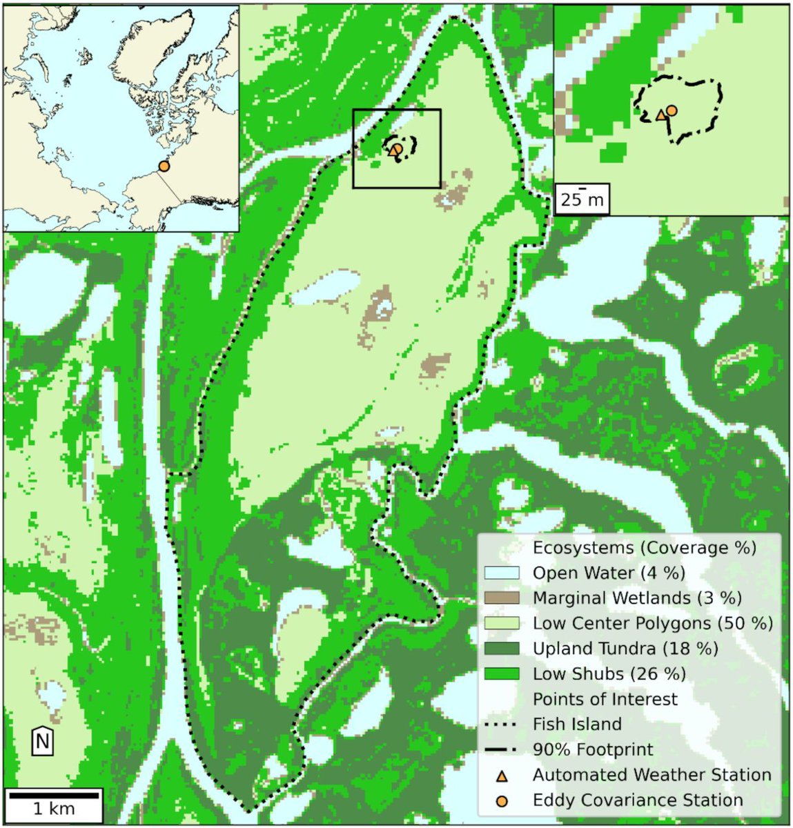
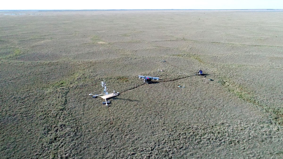
ALT Figure from paper. Caption: A 30 m resolution ecosystem classification map for Fish Island created following methods outlined in Skeeter (2022). The ecosystem classification was created using a multiyear composite (2015–2022) of LANDSAT8 data obtained from Google Earth Engine and a random forest model trained on areas representative of each ecosystem type. The training area for each ecosystem type was 6.5 ha. The inset in the top right shows a larger scale map of the automated weather station (AWS) and the eddy covariance (EC) station in 2017 along with the boundaries of the 90% cumulative flux footprint for the EC station. Both the main map and inset in the top right are in NAD 1983 UTM Zone 8N. The inset in the top left shows the site's location in the broader Arctic region, using a shapefile of the circumpolar land areas obtained from the Circumpolar Arctic Vegetation Map (Walker et al. 2005). This inset is in the WGS 1984 North Pole Lambert Azimuthal Equal Area coordinate system.
The @eucor#MobiLab roadshow vists @Freiburg this week. Can artificial intelligence inform and support cities in developing effective climate adaption strategies? We feature our project "I4C - Intelligence for Cities" @UniFreiburg on June 29 and 30 at Platz der alten Synagoge.
Our new paper in @ArcticScienceJ by @UBCGeog and
@UniFreiburg applies neural networks to model carbon fluxes between a polygon tundra and atmosphere: Warming climate reduces carbon uptake and longer growing seasons correlate with stronger methane emissions dx.doi.org/10.1139/AS-2022-0…