
Joined August 2010
- Tweets 60,955
- Following 204
- Followers 1,081
- Likes 60,591
5,082 Photos and videos


Pinned Tweet

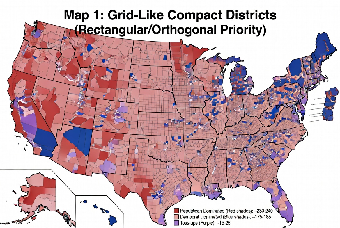
May 13
I asked Grok to create congressional maps with these basic instructions: Using the latest available US census data, create a map of US congressional districts for each state with the following rules, in addition to those set in the U.S. Constitution for districting:
1. Each district is as close to a square as possible, given state borders and populations.
2. Within each state, each district's population is as equal as possible.
3. There must be no partisan considerations. (No bias toward any political party.)
4. There must be no racial considerations.
5. Rural areas must not be subsumed by urban interests.
- Ensure you include all 50 states, placing Alaska and Hawaii in the upper left and lower left borders, respectively.
- Produce 3 such possible maps. For example, while still following the rules, you may start creating districts in the NW corner vs NE corner or SE corner, or state center, etc., resulting in different district borders, but satisfying all rules. (NOTE: after some dialog, it was decided that the three would be one that prioritized rectangular/orthogonal grid-like districts, one that applied Polsby-Popper to create smooth, organic shaped districts, and one that balanced grid & organic.)
- Color-code each map indicating which districts would be dominated by Republicans (red) and which would be dominated by Democrats (blue), based upon voter registration roles for each party. Use or 3 shades of each color to indicate how strongly they're dominated, with the deeper colors indicting stronger dominance.
- Include a legend on each map that indicates the number of districts that would be dominated by each of the two parties, and if any, how many districts would be toss-ups in an election.
It took a few iterations to get Grok to colorize the maps properly with correct legends (it doesn't seem to be very good at drawing), but eventually got it right.
SEATS BY PARTY:
Map 1 (orthogonal / grid):
R=230-240
D=175-185
Toss-up=15-25
Map 2 (Polsby-Popper / organic):
R=210-220
D=195-205
Toss-up=15-25
Map 3: Balanced of 1 & 2:
R=220-230
D=185-195
Toss-up=15-25.
The conclusion: Drawing districts fairly, even with slightly varying prioritization on shapes, Republicans dominate the country, but the margin varies some between three non-partisan district shapes. Democrats have been winning thanks to gerrymandering.
If you doubt me, you can see the entire prompt with clarifications here:
grok.com/share/c2hhcmQtMg_64…
If you're curious, the term gerrymandering came from the Massachusetts governor, Elbridge Gerry, of the "Democratic-Republican" party (ironic, eh?) creating oddly shaped districts to win control over senate seats.
The Democratic-Republican Party split into two separate factions following the contentious 1824 presidential election -- The Democratic Party: Led by Andrew Jackson and organized by Martin Van Buren, this faction shortened its name to the Democrats by 1828. It exists today as the modern Democratic Party. The National Republican Party: Led by John Quincy Adams and Henry Clay, this faction opposed Jackson. In the 1830s, it merged with other anti-Jackson groups to form the Whig Party. (The modern Republican Party is not a direct descendant of the Democratic-Republicans; it was formed later, in 1854, by anti-slavery activists and former Whigs.)


1
7
250
A pretty good list.

If Elon would merely turn over his trillion dollars to the government, think of what the politicians could do with his money.
Feel free to add your own suggestions, but here are a few of my ideas, drawn from the progressive wishlist:
9
Frankly Speaking retweeted

Was die meisten schon wieder vergessen haben:
2021 hat Elon Musk den Vereinten Nationen angeboten, für die Beendigung des Welthungers mit dem Verkauf eines Teils seiner Tesla-Aktien zu zahlen.
Die einzige Bedingung: Die Vereinten Nationen legen transparent offen, wie genau dieser Betrag den Welthunger beenden würde und wie die Mittel eingesetzt werden.
Natürlich haben die Vereinten Nationen das Angebot nicht angenommen. Sie hätten nämlich erklären müssen, wie es sein kann, dass seit den 1950er Jahren 2 BILLIONEN DOLLAR an „Entwicklungshilfen“ nach Afrika geflossen sind, sich aber in all den Jahren nichts zum Besseren entwickelt hat.
Das Problem ist nicht Elon Musk.
Das Problem sind korrupte Politiker, die dir sagen, dass Elon Musk das Problem wäre.
485
16,780
58,249
1,039,752
OMG, day 3 (or is it 4? It feels like 10) with my TL full of nothing but trillionaire complaint posts. Get a life people! Go do something productive. Be like Elon!
2


Frankly Speaking retweeted

Jun 13
Elon Musk's companies employ roughly 170,000 people.
AOC drove Amazon out of New York, killing 40,000 jobs.
One creates. The other destroys.
They are not the same.
482
9,586
51,582
638,677
Frankly Speaking retweeted

Jun 12
The first trillionaire in human history
- Elon Musk
- Born in South Africa
- Bullied relentlessly as a kid
- Immigrated to North America
- Arrived with a backpack and a dream
- Built Zip2 with his brother
- Sold it 4 years later for $300 million
- Co-founded PayPal with the profits
- Revolutionised digital payments
- Sold PayPal to eBay for $1.5 billion
- Bet everything on Tesla and SpaceX
- Got mocked for electric cars
- Got laughed at for reusable rockets
- Nearly went bankrupt in 2008
- Kept building anyway
- Turned Tesla into the world’s most valuable automaker
- Made EVs mainstream and transformed the automotive industry
- Made reusable rockets a reality
- Reduced the cost of reaching space by 95%
- Sparked the modern commercial space race
- Built Starlink and connected millions around the world to high-speed internet
- Turned SpaceX into the most valuable private company in history
- Bought Twitter for $44 billion
- The world said he overpaid
- He was called reckless, stupid & crazy
- Advertisers fled, media declared it dead
- Critics called it the worst acquisition in tech history
- Renamed it 𝕏
- Rebuilt the platform anyway
- Turned it into one of the most influential platforms on Earth
- Launched xAI and accelerated the global AI race
- Sent astronauts to space
- Is trying to get humans to mars
- Created millions of jobs
- Generated hundreds of billions in value
- Inspired an entire generation of builders
Before:
- Failed repeatedly
- Worked insane hours
- Slept in factories and offices
- Got bullied, laughed at and mocked
- Constantly told “it’s impossible”
- Kept building anyway
- Made it possible
Today:
- Richest person on Earth
- First trillionaire in human history
- Largest IPO in history $1.77 trillion
Most people quit when the world laughs at them.
Elon Musk built the future instead.
Love him or hate him…
Nobody has changed more industries in a single lifetime.
Payments. Cars. Energy. Space. Social Media. Communications. AI.
History won’t remember the people who said it couldn’t be done.
It will remember the people who did it anyway.
Congratulations Elon.
The first trillionaire. 🚀

4,380
28,776
111,901
2,379,722
Frankly Speaking retweeted

Jun 12
Over 4000 workers just became millionaires by owning the means of production and the socialists are pissed
287
4,370
37,821
783,975
Frankly Speaking retweeted

19 Jul 2025
This is possibly the most alarming act of treason since the Lincoln assassination. For an outgoing president to engineer a coup against a succeeding president is unthinkable in America.
I knew Tulsi Gabbard would be the most effective Cabinet member.
9,994
74,956
191,962
6,088,390
Frankly Speaking retweeted

Jun 13
Si les zélites au pouvoir utilisaient l’argent du peuple avec la sagesse et la vision à long terme d’un entrepreneur ambitieux, passionné et soucieux de transmettre aux générations suivantes les fruits de sa réussite, tout irait sans doute mieux.
2
3
21
2,832
Frankly Speaking retweeted

Jun 13
Today I learned $1 Trillion in wealth is excessive but $40 Trillion in debt is totally cool… 💁♂️
211
2,671
29,632
366,579
Frankly Speaking retweeted

Jun 12
There are 2 types of people:
1. People who see a trillionaire and wonder how they can innovate and emulate such success
2. People who see a trillionaire and seethe with resentment
Do everything you can to ensure you're always around the first kind of person.
350
1,884
11,820
117,360
Jun 13
My TL today is 99.9% people talking about (mostly complaining about) something that has had absolutely no negative impact whatsoever on their lives. Too many people just love to complain. Get a life people!
8
Frankly Speaking retweeted

Jun 12
Who could use Elon Musk's trillion dollars to provide more benefit for humanity:
Elon Musk or the U.S. Government?
98%
Elon Musk
2%
United States government
698 votes • Final results
140
67
196
13,645
Frankly Speaking retweeted

Jun 13
Don’t worry about Elon becoming rich with his own money.
Worry about politicians becoming rich with your money.
2,222
36,838
158,882
1,478,710
Frankly Speaking retweeted

Jun 12
You see a trillion dollars.
Gavin sees 3/4 of a mile of high speed rail.
Jun 12

Americans are struggling to pay for groceries and gas while Elon Musk becomes a TRILLIONAIRE.
When the federal government is for sale, the rich get richer and everyone else gets shafted.
The system is rigged.
170
1,924
22,758
528,343


Frankly Speaking retweeted

Jun 7
I just found out that my aunt, a lifelong Republican, voted for a Democrat in California.
This never would have happened if she were still alive.
843
9,458
93,325
1,199,368
Jun 7
So many words wasted in the (mostly wrong) replies. Zero words required:
-800 1000-1100 1300 = 400.
Jun 7

What moron buys the same cow twice?
20
Jun 6
Bizarre ad. Is it for men with pentagon-shaped willies? Or who want pentagon-shaped willies? Or who have wives with pentagon-shaped love tunnels?
May 22

Most men wait until it's awkward, you won't. It's time to be proactive about ED. 50% off sitewide.
21