
Joined October 2022
- Tweets 528
- Following 13
- Followers 5,228
- Likes 382
227 Photos and videos


Reflex retweeted

Apr 29
We released Reflex 0.9 - every action in your app is now callable by an AI agent out of the box.
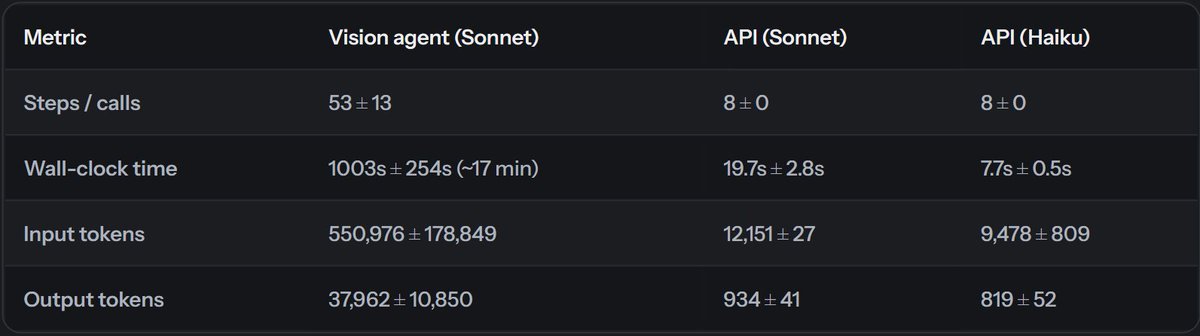
We ran a benchmark comparing two approaches to letting AI agents interact with a web app:
- A vision agent (browser/computer use) that screenshots the UI and clicks around
- An API agent that calls HTTP endpoints directly
The task for both agents was to find a "Smith" customer with the most orders, accept their pending reviews, and mark their most recent order as delivered. We chose this task since it's similar to automation work a typical tool sees.
The vision agent took 550k tokens and 17 minutes on average. The API agent took 12k tokens and 19.7 seconds. Of course, API agents are faster and more token efficient since they don't need to take screenshots and directly interface with the UI. The problem is many apps don't have APIs for every action, since it takes engineering overhead to build and maintain each separate API codebase.
We built a plugin for Reflex that auto-generates HTTP endpoints from your app's existing event handlers. Your app has a button with an on_click handler, the plugin exposes that handler as an endpoint. An agent can call the same function a human click triggers. No separate API to build or maintain.
As agents become a bigger share of your app's users, every action needs to be callable by code - not just by clicking a button.
Benchmark: reflex.dev/blog/vision-agent…
5
2
11
757
Reflex retweeted

9 Dec 2025
Less than 1 year ago I had no idea of how to build a web app.
Yet we had to scale @FantaMasterApp and bring it from mobile to web.
With hard work, and also thanks to @getreflex, my Python skills allowed me to generate almost $100K in revenues.
Never give up!
#buildinpublic
1
6
948
Reflex retweeted

10 Nov 2025
Auth from prompt to production with @getreflex and @descopeinc
Build the full-stack Python app of your dreams with:
☑️ User auth (magic links, passkeys, socials, etc.)
☑️ B2B auth (SAML / OIDC SSO)
☑️ MFA
☑️ User, role, tenant management
🧵👇
1
2
6
855
Reflex retweeted

3 Nov 2025
This video for @getreflex was completely AI generated
Pretty crazy to believe in the future anyone will be able to tell stories like this in a few seconds
5
1
15
1,523
Reflex retweeted

23 Oct 2025
Reflex (@getreflex) is an AI app builder for creating production-grade web apps entirely in Python, powered by its own open-source framework.
Just connect your data and enter a prompt. It generates production-ready apps that integrate any data source, API, or Python package.
Reflex has over 1M apps created, 27k GitHub stars, and has been used by 30% of Fortune 500 companies for internal tools and data-driven applications.
reflex.dev
21
16
111
18,030
Reflex retweeted

9 Oct 2025
Python devs, check this out. You can build full-stack apps from a single prompt and have them running the same afternoon.
I’ve been trying @getreflex, an open-source Python framework and AI App Builder that goes from prompt to production in minutes. Everything, front end and back end, stays in Python with the flexibility and performance you’d expect from a JS app.
It automatically connects to any PyPI package or API. It built a real-time sales dashboard tracking revenue, conversion rates, and team performance across regions with live updates, all in Python.
If you build internal tools, dashboards, or AI-powered apps, this is one of those “how did I not know about this earlier” tools. Shoutout to them for sponsoring this post.
Check it out: reflexdev.org/beA6TkN
8
4
73
9,536

8 Oct 2025
AI video is getting pretty good - should we make Reflex the movie? ...
1
1
9
1,152
Reflex retweeted

3 Oct 2025
Let's build a Data Analysis app in Python (both frontend and backend) with just a prompt:
1
7
32
10,006
Reflex retweeted

18 Sep 2025
Me han nominado a los Sirviendo Código Awards por mi artículo sobre desarrollo web con Python!
Si quieres leerlo y apoyar mi trabajo, puedes votarlo desde aquí. Gracias!
→ sirviendocodigoawards.com/?n…

7
20
125
11,038
Reflex retweeted

15 Sep 2025
🚀 We’re excited to welcome @Reflex as a sponsor of The AI Conference 2025!
They’re making full-stack app development frictionless: build web apps using just Python, or describe what you want and let their AI Builder generate working code—from frontend to backend—with built-in deployment. No JavaScript required.

1
6
745

28 Aug 2025
We're excited to show you something pretty cool with Reflex's new mapping components.
Building interactive maps in Python web apps used to mean wrestling with JavaScript libraries or settling for static images. Not anymore.
With Reflex Enterprise, you get full-featured maps built on Leaflet; markers, layers, event handling, the works. All in pure Python.
What makes this powerful:
- No JavaScript required - everything stays in your Python workflow
- Real-time interactions - click handlers, zoom events, location tracking
- Programmatic control - fly to locations, fit bounds, add/remove layers dynamically
- Mobile-friendly out of the box
Perfect for dashboards, analytics apps, or any project where you need to visualize location data without the usual frontend complexity.
Docs → lnkd.in/evzNDneZ
Reflex → lnkd.in/ehzKkM4A
What are you building with mapping features in your Python apps? We'd love to hear about your projects!
2
16
1,336
6 Aug 2025
Reflex just crossed 25k Stars in Github, and is the has been a top trending repository for the past few days!
1
3
40
9,077
Reflex retweeted
23 Jul 2025
Interesting app someone built with @getreflex and @openrouter
- Has built in Auth, Search and Deepthinking built in
- Chat with hosted models on openrouter (gemini for general chat, perplexity for web search & cerebras(qwen) for fast response)
- Optionally use local models from Ollama and LMStudio when run locally
Link Github below
1
2
13
1,223
Reflex retweeted
22 Jul 2025
Mi paso por la PyConES 2024 en dos imágenes 😬
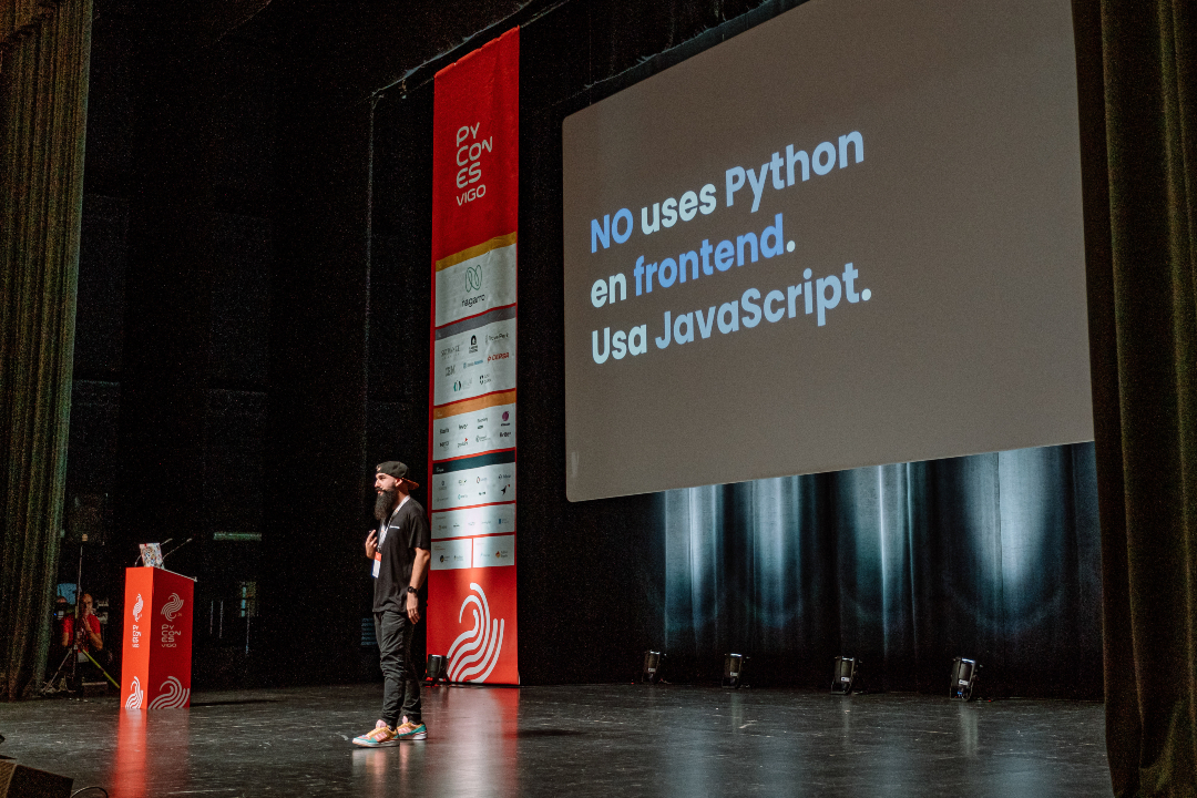

6
6
153
11,762
3 Jul 2025
Reflex v0.8.0 is out! Major performance improvements in this update.
5
6
39
2,753
1 Jul 2025
3
21
2,349