
𝗙𝗟𝗬𝗚𝗛𝗧 𝗱𝗲𝗹𝗶𝘃𝗲𝗿𝘀 𝗱𝗿𝗼𝗻𝗲-𝗽𝗼𝘄𝗲𝗿𝗲𝗱 𝗶𝗻𝘁𝗲𝗹𝗹𝗶𝗴𝗲𝗻𝗰𝗲 𝘁𝗼 𝘃𝗮𝗿𝗶𝗲𝗱 𝘀𝗲𝗰𝘁𝗼𝗿𝘀 𝘂𝘀𝗶𝗻𝗴 𝗗𝗮𝗮𝗦 𝗠𝗼𝗱𝗲𝗹
Read more: oemupdate.com/news/flyght-de…
#DaaS #DroneTechnology #TechInnovation #SmartDrones #DroneServices #TechForBusiness #AerialData

18

Turn data into powerful insights 🌍📊
Join our Mapping & Survey Course and learn how to capture, process, and analyze aerial data for real-world applications—from land surveys to construction planning.
#DroneMapping #Surveying #Geospatial #AerialData #GIS #DroneTraining

15

Feb 3
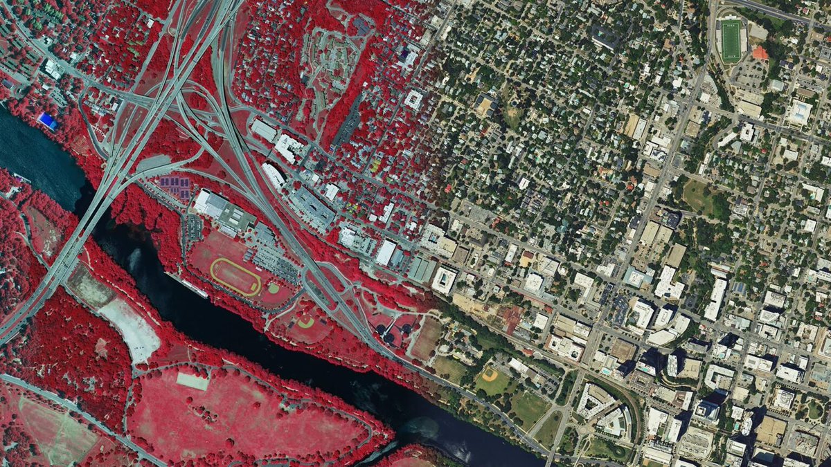
ZenaTech has signed an offer to acquire a three-decade-old Virginia-based land surveying company with an established customer base in the Washington, D.C. metro area. Once completed, this acquisition will further strengthen the company's Drone as a Service (DAAS) presence in the region, combining with the previously announced acquisition. ZenaTech plans to expand opportunities to deliver its DAAS solutions to multiple federal government agencies.
“The Washington, D.C. area is one of the most strategically important markets in the US, and this potential acquisition expands our Drone as a Service footprint in the D.C. metro area where we believe that there is great demand for advanced drone technology services to federal agencies that we believe we can best fill,” said Shaun Passley, Ph.D., ZenaTech CEO. “This proposed acquisition strengthens our Drone as a Service capability in a region where demand for drone-based solutions continues to grow. Expanding our presence here positions ZenaTech to deepen relationships with federal, state, and municipal agencies and support long-term infrastructure and modernization initiatives.”
“We believe we offer superior drone-based autonomy platforms that can help agencies perform vital inspection, surveying and compliance tasks more efficiently without the expense of their owning a fleet of drones. In addition, we expect this expansion into the D.C. metro area will lead to additional revenue-generating opportunities for our ZenaDrone platforms in the future,” concluded Passley.
Read the full story: zenatech.com/zenatech-signs-…
$ZENA $49Q #ZenaTech #DroneasaService #DaaS #DroneTechnology #AerialData #FederalAgencies #Geospatial #Surveying #DroneIndustry

1
7
13
1,472

Powering smarter infrastructure with aerial intelligence.
From faster inspections to safer operations, drones are redefining how critical assets are monitored, accurately, efficiently, and without risk.
#GarudaAerospace #DroneInspection #InfrastructureTech #AerialData #SmartOperations
5
51
58
234
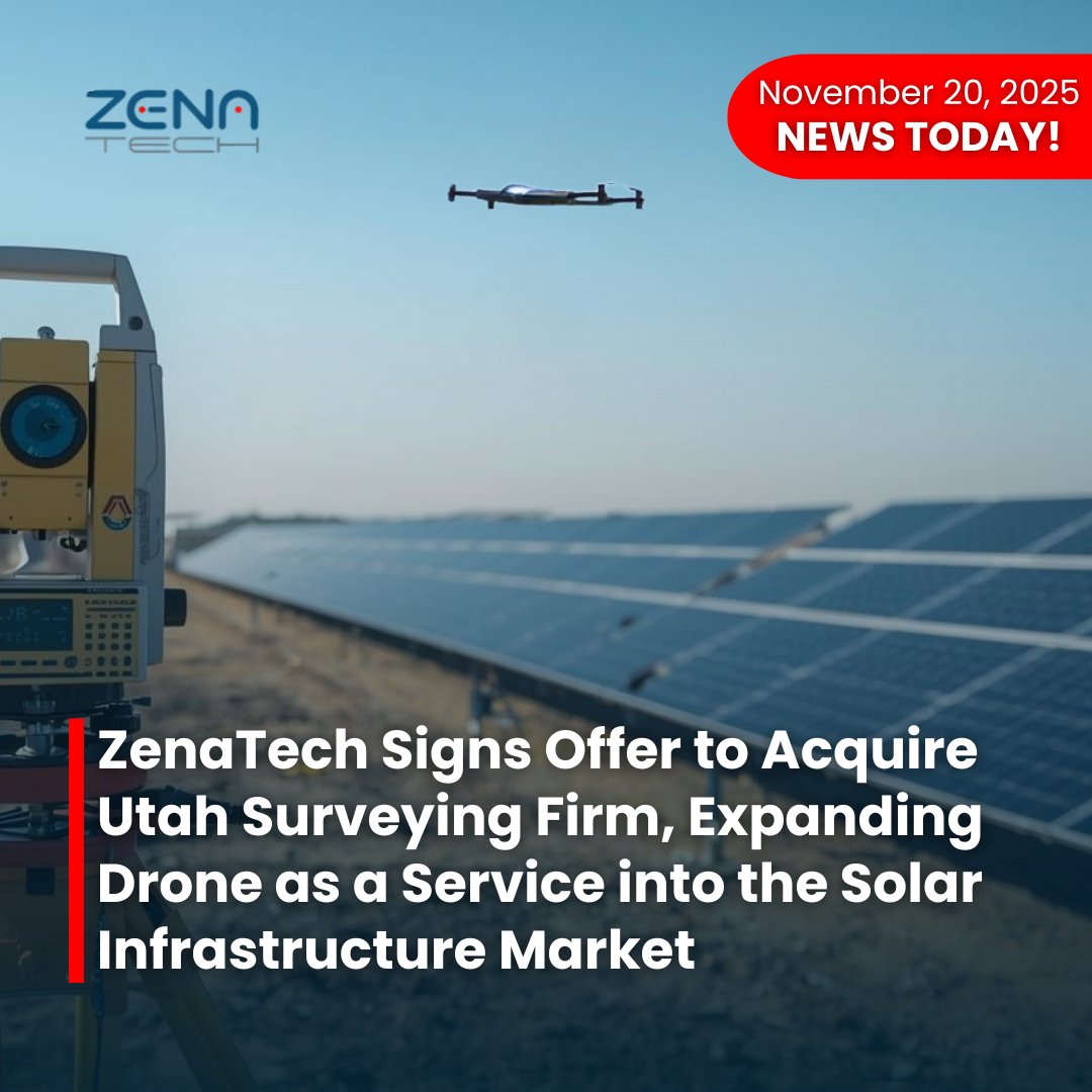
20 Nov 2025
ZenaTech announces it has signed an offer to acquire a well-established Utah-based commercial surveying and 3D mapping company specializing in LiDAR processing, drone-enabled data capture, and large-scale solar site development clients. This acquisition represents ZenaTech’s strategic entry into the fast-expanding solar infrastructure market, unlocking new growth avenues for advanced aerial data services for developers engaged in planning, design, construction, and maintenance of solar farms and other solar energy projects.
“Entering the commercial solar development and maintenance sector is a significant milestone for ZenaTech,” said Shaun Passley, Ph.D., CEO of ZenaTech. “Solar infrastructure demands high-precision surveying and rapid data turnaround. This acquisition instantly brings these capabilities to our Drone as a Service platform and expands us into this untapped market to provide scalable, drone-enabled solutions that will drive efficiency and speed.”
Read the full story: zenatech.com/zenatech-signs-…
$ZENA $49Q #ZenaTech #Acquisition #SolarInfrastructure #RenewableEnergy #DroneServices #LiDAR #3DMapping #SolarFarm #Geospatial #TechNews #BusinessGrowth #CleanEnergy #PrecisionSurveying #AerialData
2
5
11
976

19 Nov 2025
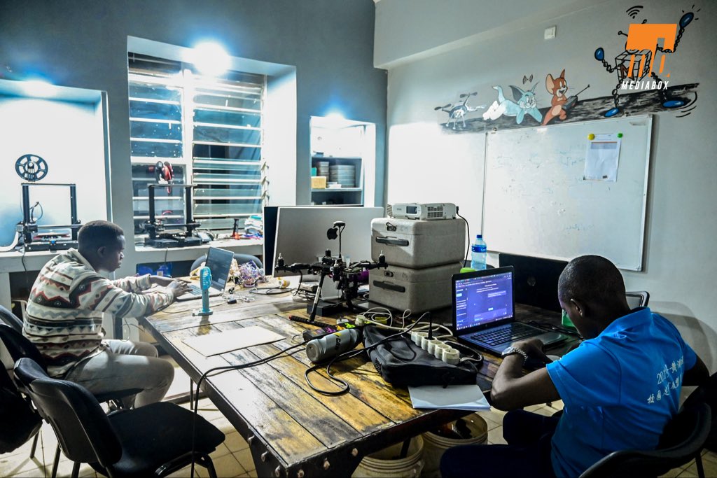
🇧🇮 Fabrication Souveraine : L'Ingénierie Aérienne de #Mediabox Prend Son Envol.
L'innovation n'est pas une intention, elle est une réalité qui prend son envol. Nos drones ne sont pas issus de catalogues ; ils sont le fruit de nos ateliers, imaginés, modélisés et assemblés localement, pièce par pièce.
Notre philosophie est de capitaliser sur les innovations mondiales pour les adapter intelligemment à notre réalité technique et économique. En modélisant les pièces manquantes et en utilisant l'impression 3D en interne, nous réduisons le coût d'un modèle performant de 3 000 à 400 dollars. L'innovation se mesure à sa capacité à être accessible et reproductible.
La preuve irréfutable de cette maîtrise est double : nous sommes des constructeurs d'intelligence distribuée, et cette ingénierie est reconnue. Le premier drone assemblé localement par Mediabox a reçu un numéro de série officiel de l’Agence de l’Aviation Civile du #Burundi. C'est un symbole fort : celui d’une ingénierie qui ne s'imite pas, mais qui s’affirme par la conformité nationale.
Équipés de capteurs optiques multispectraux, nos #Drones ne volent pas pour voir ; ils volent pour comprendre. Ils capturent des imageries agronomiques de précision, analysées par intelligence artificielle. Ces flux sont ensuite fusionnés avec nos plateformes #IoT et bases géospatiales, fournissant des cartes dynamiques de suivi environnemental et agricole. Chaque vol nourrit la décision stratégique.
Notre approche fournit des solutions aériennes scalables, interopérables et prêtes à l’exportation. Nous n’importons pas l’avenir. Nous l’assemblons.
#AerialData #SovereignTech #3DPrinting #SmartAgriculture #Innovation #EWS


2
7
27
3,850
21 Oct 2025
ZenaTech Inc announces that it has signed an offer to acquire a Southern California-based land survey engineering firm known for its extensive experience in public works and its longstanding relationships with government and commercial builder clients. This acquisition aims to expand ZenaTech’s DaaS footprint in Southern California, creating new opportunities to modernize and improve surveying, inspection, monitoring and wildfire management solutions for both government and commercial sector customers through drone technology.
“Southern California is one of the largest and most dynamic public works and infrastructure-driven regions in the country — from transportation expansion and utility modernization to environmental land planning,” said Shaun Passley, Ph.D., ZenaTech CEO.
Full release: zenatech.com/zenatech-to-exp……
$ZENA $49Q #ZenaTech #DroneTechnology #AcquisitionNews #SurveyingInnovation #InfrastructureDevelopment #PublicWorks #WildfireManagement #AerialData #SmartConstruction

4
11
513

6 Oct 2025
Water management is getting smarter. 💧🤖
Autonomous drones now survey reservoirs, inspect sewers, and monitor water quality in real time—cutting risk, boosting analytics, and protecting public health.
1upaerial.com/drones-transfo…
#WaterTech #DroneMonitoring #SmartWater #AerialData
1
2
31

10 Sep 2025
Discover the future of drone data management with FLYGHT CLOUD.
From planning and capturing to processing, analyzing, and sharing - turn aerial data into actionable intelligence at scale.
1. Faster processing
2. Smarter visualization
3. Enhanced compliance
4. Real-time collaboration
5. Works with data from any drone
Get 2,500 free credits now - no commitment required! Use them anytime before March 2026 and experience the next generation of drone data management.
Start your #GIS project today with #FLYGHTCLOUD - for free! Know more flyghtcloud.ideaforgetech.co…
#DroneData #DroneDataStorage #DroneTech #AerialData #MissionPlanning

2
3
514
5 Sep 2025
FLYGHT CLOUD 2.0 - Redefining Drone Data Management
From planning missions to capturing, processing, and analyzing data, FLYGHT CLOUD 2.0 brings everything together in one seamless platform. Collaborate effortlessly, share insights instantly, and make faster, smarter decisions with your team - wherever they are.
And with the new FLYGHT VIDEO capability, your mission’s eye in the sky is reimagined: upload footage instantly, view video alongside flight paths, tag incidents, add notes, and export only what matters - fast, secure, and audit-ready.
Centralized. Secure. Seamless.
Explore more: flyghtcloud.ideaforgetech.co…
#DroneTech #DroneData #FLYGHTCLOUD #AerialData #MissionPlanning
3
3
354

29 Jun 2025
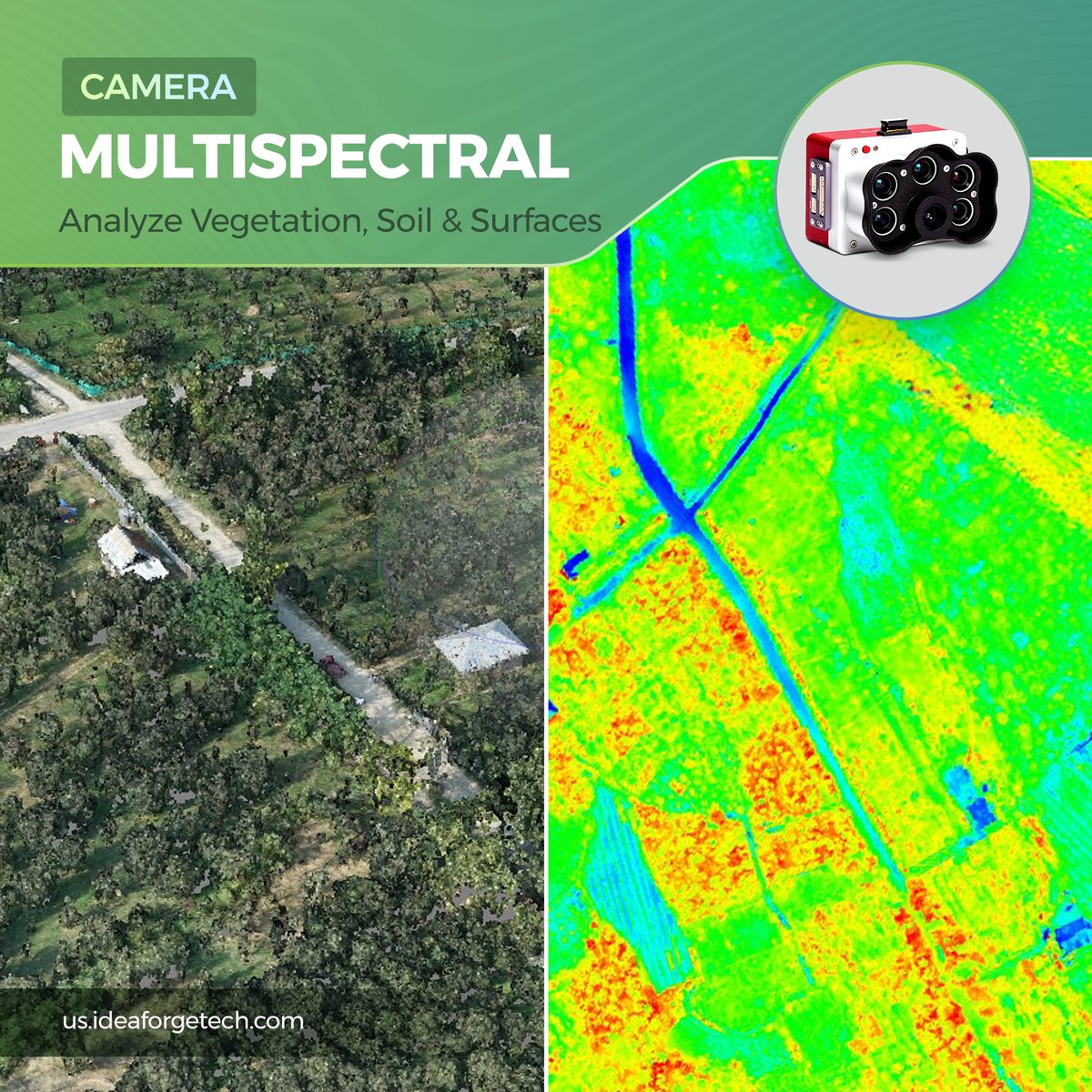
#Multispectral Payloads - Analyze Vegetation, Soil & Surfaces. By capturing data across multiple light bands, multispectral sensors uncover spectral patterns invisible to the eye—supporting detailed surface analysis. #AerialData #PayloadTechnology
1
2
4
90

28 May 2025
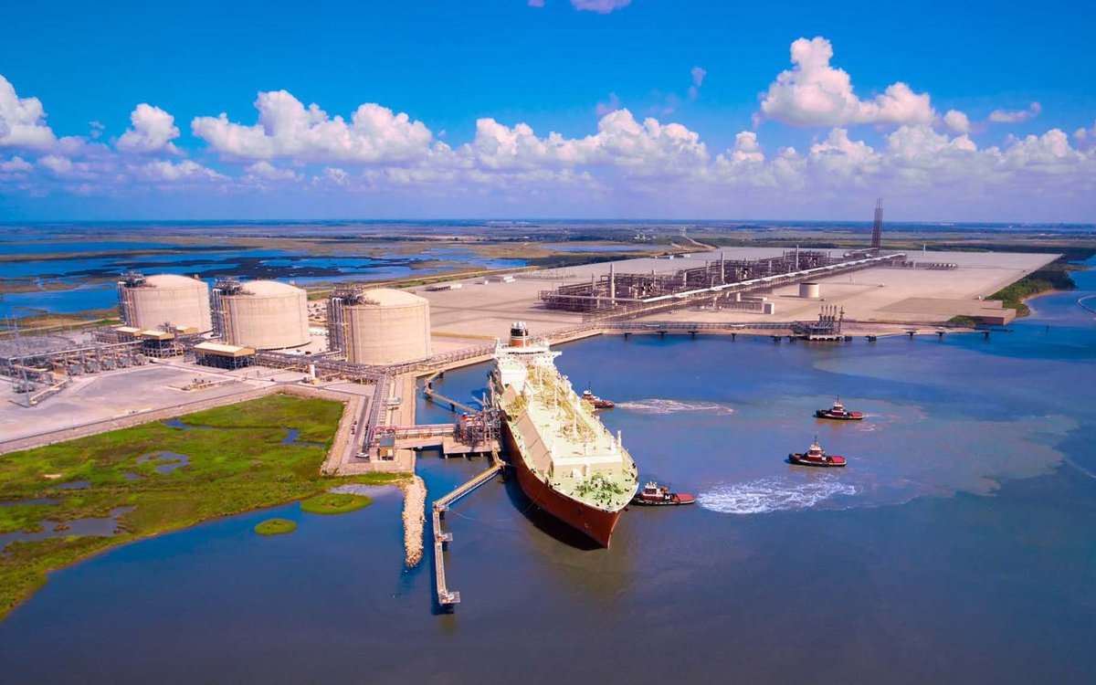
⛽️🌐 From this height it looks like “just” an LNG tanker docking—but zoom in on the data and you’ll see a live, breathing KPI dashboard:
Every meter of pipeline is GPS-anchored for stress-corrosion monitoring.
Tank roof temps are tracked hourly via hyperspectral fly-overs to catch boil-off before it’s a headline.
Tug wake patterns? They’re a proxy for berth-side sediment change—and a six-figure dredging bill avoided.
When energy majors marry high-res aerial intelligence with on-site SCADA, the dock isn’t a bottleneck; it’s an algorithm.
hashtag#GeospatialIntelligence hashtag#LNG hashtag#EnergyInnovation hashtag#AerialData hashtag#DigitalTwin
3
14

25 Dec 2024
Drones are not just toys.
They’re transforming industries:
Precision farming.
Infrastructure inspection.
Environmental monitoring.
The sky isn’t the limit—it’s the beginning.
Daily tips 😉 @simeontaskaris
#Drones #Innovation #Technology #FutureOfWork #AerialData
1
1
61

13 Aug 2024
Dive into the world of aerial data collection with Janne Hietala, CEO of Kelluu, on the latest Drone Radio Show episode! Explore how hydrogen-powered airships are changing the game. #AerialData #Innovation #DroneTechnology #Kelluu bit.ly/408Ac8t

2
86

23 Jul 2024
Hexagon Announces Refresh of High-Resolution #aerialdata for 14 U.S. States #lidar
lidarnews.com/press-releases…
1
149
14 Jul 2024
Dive into the world of aerial data collection with Janne Hietala, CEO of Kelluu, on the latest Drone Radio Show episode! Explore how hydrogen-powered airships are changing the game. #AerialData #Innovation #DroneTechnology #Kelluu bit.ly/408Ac8t

1
96

11 Jul 2024
🚁📸 Sony and Gremsy Team Up for Cutting-Edge Drone Imaging Solutions 🌍🚀
🔍 Discover the innovative partnership between Sony and Gremsy, bringing advanced imaging technology to the drone industry. This article explores the state-of-the-art features, applications, and benefits of their latest drone imaging solutions, revolutionizing aerial photography and data collection. Essential for tech enthusiasts and industry professionals! 🌟📡
👉 Read the full article on Highways Today: highways.today/2024/07/09/so…
#DroneTechnology #HighwaysToday #Sony #Gremsy #AerialImaging #AdvancedPhotography #TechInnovation #DroneImaging #AerialData #CuttingEdgeTech
4
4
60
30 Apr 2024
Dive into the world of aerial data collection with Janne Hietala, CEO of Kelluu, on the latest Drone Radio Show episode! Explore how hydrogen-powered airships are changing the game. #AerialData #Innovation #DroneTechnology #Kelluu bit.ly/408Ac8t

1
62
31 Dec 2023
Dive into the world of aerial data collection with Janne Hietala, CEO of Kelluu, on the latest Drone Radio Show episode! Explore how hydrogen-powered airships are changing the game. #AerialData #Innovation #DroneTechnology #Kelluu bit.ly/408Ac8t

1
134

5 Sep 2023
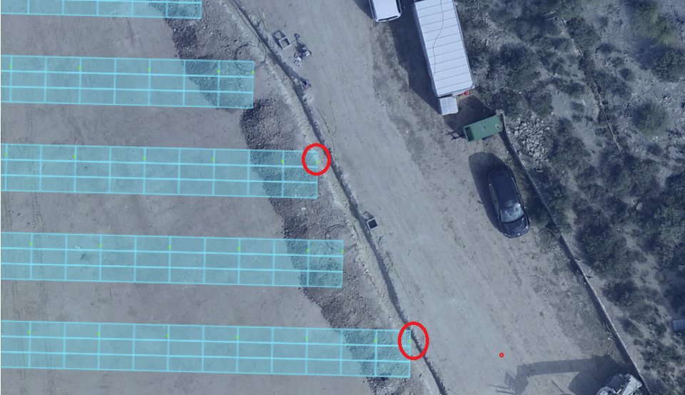
Mistakes happen... Like here, where a pile was misplaced while constructing a new solar site.
💡 Scanning the site and adding it to its digital twin can help validate different solutions to mitigate the issue.
bit.ly/3pNnhLz
#digitaltwin #aerialdata #solarconstruction
1
3
123