

Jun 12
When location, positioning, and context matter, trust in spatial data becomes mission critical.
Recent reporting from @arstechnica highlights growing concerns around GPS interference and the resilience of positioning systems. It is a reminder that organizations operating in complex or contested environments cannot rely on any single signal, source, or system to understand where they are and what is happening around them.
That is where Vantor’s spatial foundation plays an important role. Combining decades of imagery, global 2D basemaps, 3D terrain, and map-ready features, it provides a trusted source of ground truth for humans, machines, and AI-powered systems.
Raptor uses this trusted foundation as a reference point. By comparing a drone’s video feed to Vantor’s 3D data, Raptor supports navigation and coordinate generation when GPS may be unavailable, degraded, or unreliable. From identifying precise locations and extracted points to understanding spatial relationships across complex environments, Raptor helps deliver actionable insight when accuracy and confidence matter most.
The visual below shows a drone video feed using Raptor to navigate against Vantor’s 3D data. It reinforces a simple but critical idea: coordinate extraction is only as reliable as the data behind it, which is why a trusted spatial foundation matters to navigate.
Read the Ars Technica article for more context on GPS interference and resilience in the comments, then learn more about how Raptor supports navigation without GPS:
🔗: arstechnica.com/space/2026/0…
🔗: go.vantor.com/autonomy-witho…
1
5
18
2,826


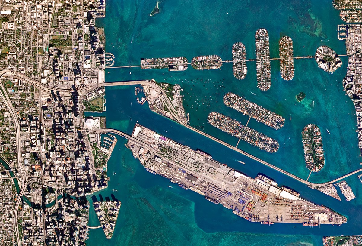
1/2 - We just updated our basemaps in the DB4P archives.
The new basemaps include more information, such as topography and more location names.

1
11
29
1,987

Jun 3
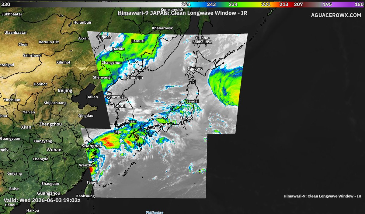
Aguacero 5.8 is live.
🛰 GOES-West & Himawari, satellite coverage across the whole Pacific
⚡ Lightning counter for layouts & popups
🎨 Brightness/contrast/saturation sliders for satellite basemaps
📦 Bundles can now save the model they were built with
aguacerowx.com

2
10
58
5,916

May 29
I'm excited to introduce GeoLibre, a lightweight, cloud-native desktop GIS built with MapLibre GL JS and Tauri.
GeoLibre is designed for modern geospatial workflows, combining the flexibility of web technologies with the performance of a native desktop application. The current prototype includes a MapLibre-powered map workspace, local vector data import, project persistence, and built-in plugins for basemaps, layer control, swipe, street view, lidar, GeoAgent, and GeoEditor integrations.
GeoLibre can run directly in a web browser or as a standalone cross-platform desktop application (<30 MB).
GitHub: github.com/opengeos/GeoLibre
Website: geolibre.app
Live demo: geolibre.app/demo
Feedback, ideas, and contributions are welcome.
#GeoLibre #GIS #Geospatial #MapLibre #OpenSource #CloudNative
5
105
661
34,071


May 21
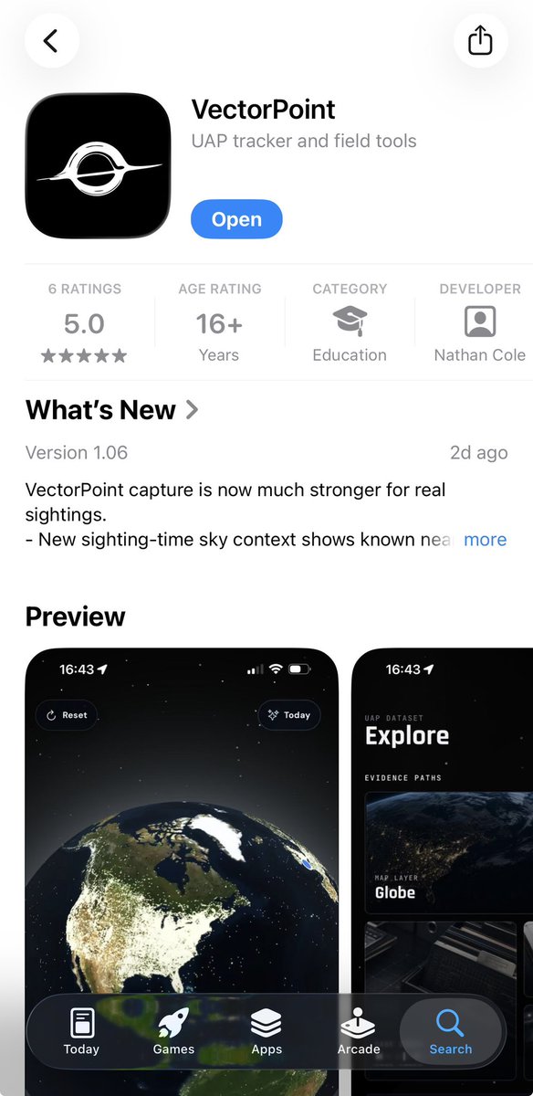
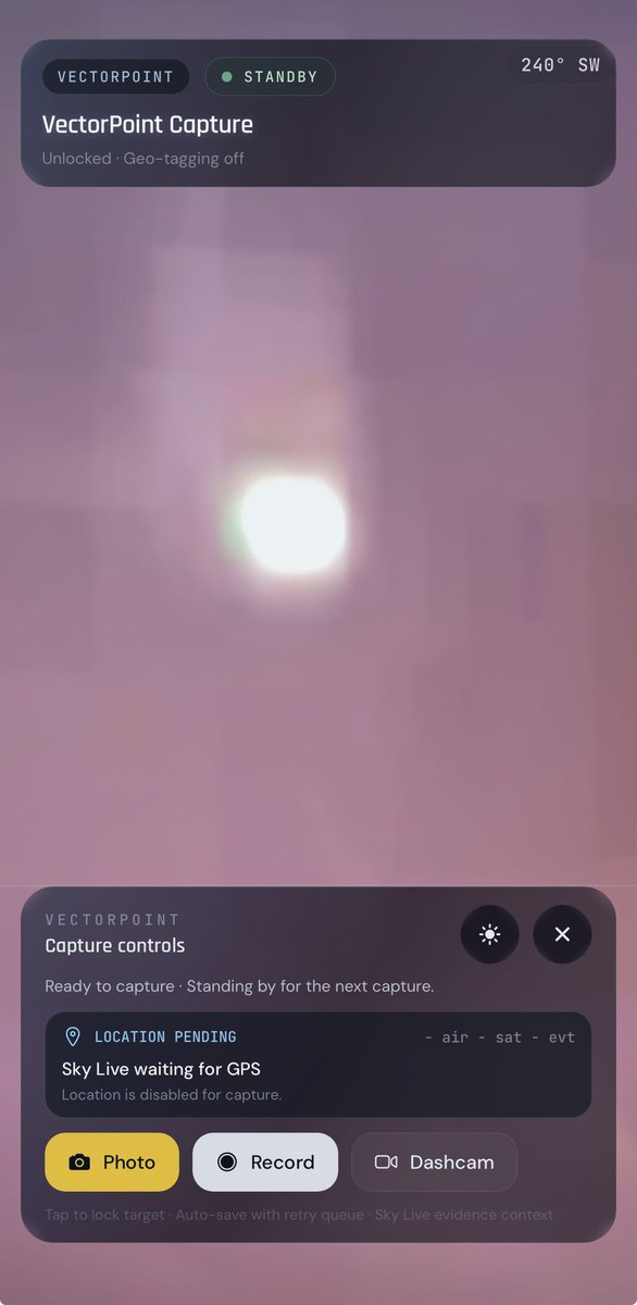
𝑽𝒆𝒄𝒕𝒐𝒓𝑷𝒐𝒊𝒏𝒕 🔥 🛸
1.4M Sightings
31K Documents
New sighting-time sky context shows known nearby aircraft, satellites, weather, astronomy, vessels, rockets, and live sky events around the time and place of your sighting.
*Nearby context is shown to help investigation, not to claim what you saw.
Planetary maps now include Earth, Moon, Mars, Mercury, and Venus, with lunar records and planetary basemaps available from the map surface. @NathanCDev


4
2
14
929

May 19
Ever been stuck on a bad road during a storm? 😬
👉 Detailed basemaps in WeatherFront help you see roads, terrain, and positioning clearly so you don't get caught out of position.
Better visibility = better decisions. ⛈️
Has WF ever helped you navigate around storms?
Follow @stormfrontfreak for ideas on how to use this detailed mapping when you hit the road!
3
22
2,505

May 6
One of the challenges that makes mapping from Second World War unit war diaries particularly difficult is the mapping system itself, specifically the coordinate grids and map projections used at the time.
The British relied on several different map projection systems, each built on geodetic datums that were, by modern standards, imprecise. For northwest Europe, the two most relevant are Lambert Zone I, based on the Nouvelle Triangulation Française (NTF) datum and the Clarke 1880 ellipsoid, and Nord de Guerre, an older WWI-era grid based on the Ancienne Triangulation Française (ATF) datum and the Plessis 1817 ellipsoid. By 1944, Nord de Guerre was technically obsolete, but it still appeared as marginal reference ticks on many British-issued map sheets. These datums were derived from earlier triangulation surveys and predated the computational methods that would later allow for globally consistent, satellite-verified reference systems.
Geodesy as a discipline was still maturing, and without computers, producing and correcting large-scale surveys was slow, laborious work, made harder by the fact that a war was actively being fought. The practical consequence for a theatre like Normandy was that available map coverage relied on conical projections, specifically Lambert Conformal Conic, rather than the narrower strip-by-strip Transverse Mercator projection that underpins the modern Military Grid Reference System (MGRS). Transverse Mercator projections perform well over narrow north-south bands but distort rapidly as you move east or west. Lambert Conic projections handle wider east-west extents better, which is why they were preferred for covering broad operational theatres. The tradeoff is that both introduce distortion of different kinds depending on where you are on the sheet, and that distortion was baked into every map issued to every unit.
Layer on top of that the generalisation inherent in the most commonly available wartime maps, the GSGS 1:100,000 series. At that scale, features must be simplified: roads straightened, villages approximated, contours smoothed and errors compounded. In practice, positional inaccuracy across these sheets typically falls in the range of 100 to 200 metres, with worse outliers possible depending on the area and the source survey data. By modern standards that is significant. GPS-guided munitions rely on sub-metre accuracy, and calling close artillery fire with that margin of error would be genuinely hazardous to friendly troops. In the Second World War, those errors were real and unavoidable, and commanders and surveyors simply had to account for them operationally.
When we mapped Project '44, we manually georeferenced each GSGS map sheet and stitched them together, tying the sheets to known, identifiable features on the ground. Done carefully, this process keeps positional accuracy near the lower end of that 100 to 200 metre range, but it cannot push below it. The original datum and projection errors, the generalisation of the source maps, and the inevitable human error in the georeferencing process all combine in ways that cannot be fully eliminated. There is a floor, and that floor is set by the accuracy of the original surveys.
Over the last several days I have been working on a new approach to reduce that residual uncertainty and speed up the mapping workflow. It is a system of systems that brings together three reference layers in one interface.
The first is the wartime grid systems, specifically the coordinate grids actually used in the war diaries, enabling direct input and plotting of grid references as they appear in the source documents. The second is the georeferenced GSGS basemaps, the original wartime maps georeferenced to a modern coordinate system, so a plotted grid reference can be visually cross-checked against the map the unit itself would have been reading. The third is a modern accurate basemap, a contemporary mapping layer using current satellite-derived data, for ground truth comparison.
The idea is convergence across three independent references. Where all three agree, you have high confidence. Where they diverge, a human mapper can apply contextual judgment, drawing on terrain, road networks, and the unit narrative, to make the call on where the position actually was. The goal is faster, more efficient mapping without sacrificing interpretive rigour. Rather than automating the decision, the tool gives the mapper the best possible information to make an informed judgment about where a unit was and what they were doing.
12
19
188
24,942

May 6
Does anyone know where the extra information comes from? Just "how satellite data typically looks like"?
What are use cases of having 2m vs 3m resolution when the added information is basically just hallucinated, am I missing something?
Basemaps I guess are one...
May 5

Today we announced Planet SuperRes, a breakthrough tech that uses AI to uplevel our PlanetScope near-daily imagery from 3 m to a much sharper 2 m resolution. 🛰️
Really cool things done by our team to make this happen. The model was trained on over 120,000 SkySat and PlanetScope satellite image pairs. We can now see things we couldn’t before -- making small-scale objects and textures visible for analysis.
Better data helps us make better decisions. planet.com/pulse/planet-supe…
2
4
201

Living Atlas is the foremost collection of curated geographic content, including ready-to-use basemaps, maps, layers, and apps from Esri and the global GIS user community.
Here are some tips for getting the most out of #LivingAtlas in your work. ow.ly/TBJn50YUj9U
2
27
May 4
🔵🔴 Celebrating 1 Year of WeatherFront 🎉🎂
On May 4, 2025, we launched an app designed to bring weather data to your fingertips with unmatched convenience. A one-stop shop. Sleek, smooth, and easy-to-use.
Since then, with your guidance, we've pushed 21 updates and continue to innovate at a rapid pace. Every step of the way, we remain committed to delivering you an enjoyable weather data viewing experience and we can't wait to see what year 2 brings!
Thank you for all you've done to support WF, whether you've been here since Day 1 or just hopped on the train recently. We literally couldn't do this without you!
In honor of our anniversary, please enjoy a throwback to the video we posted at launch (with some minor text updates). Notice how basic those basemaps were! And remember when export functionality wasn't yet built into the app?
53
40
333
58,569

Living Atlas is the foremost collection of curated geographic content, including ready-to-use basemaps, maps, layers, and apps from Esri and the global GIS user community.
Here are some tips for getting the most out of #LivingAtlas in your work. ow.ly/YRsP50YTYpU

5
23
771

Access high-resolution satellite basemaps on demand through SkyFi, with transparent pricing and no minimum commitments. 🌎
Explore, compare, and order at go.skyfi.com/basemaps
3
15
983

🌏 Provide geographic context.
🧭 Orient your readers.
🎨 Establish visual design.
Do your basemaps know their role in your geospatial story? Learn how to maximize your basemaps using the ArcGIS #StoryMaps builder:
ow.ly/aNKL50YQI03
2
14
709

With data stretching back to the start of the full-scale invasion in 2022, the map documents the impact of Russia's war on Ukraine and its people. In February 2026, CIR launched a new version of the map, replete with 15 incident categories and 19 different sectors for tracking civilian infrastructure damage. The new version also offers multiple basemaps to give you more options for data visualisation. You can view the map on our website info-res.org/eyes-on-russia/… 2/2
3
1,514
Apr 24
Ever been stuck on a bad road during a storm? 😬
👉 Detailed basemaps in WeatherFront help you see roads, terrain, and towns more clearly.
Better visibility helps you make better decisions. ⛈️
Download WF today & follow @stormfrontfreak for more storm chasing tips & tricks!
1
4
21
1,388