
Jan 27
The original map of Somalia 🇸🇴 is not what colonial-based platforms like Google Maps present today. Somalia is much larger than the 7 displayed in Google Maps and Wikipedia crapp.
Before colonization divided the land, the Somali nation encompassed all Somali-inhabited territories, including:
• Djibouti (formerly French Somaliland)
• Northern Somali regions, Western Somali regions, and the NFD (under British rule)
• Southern Somalia (formerly Italian Somaliland)
These borders were not drawn by Somalis. They were imposed by colonial powers to fragment the Somali peninsula into artificial territories. The true extent of Somalia is symbolized by the five-pointed star on the Somali flag, not by modern colonial maps.
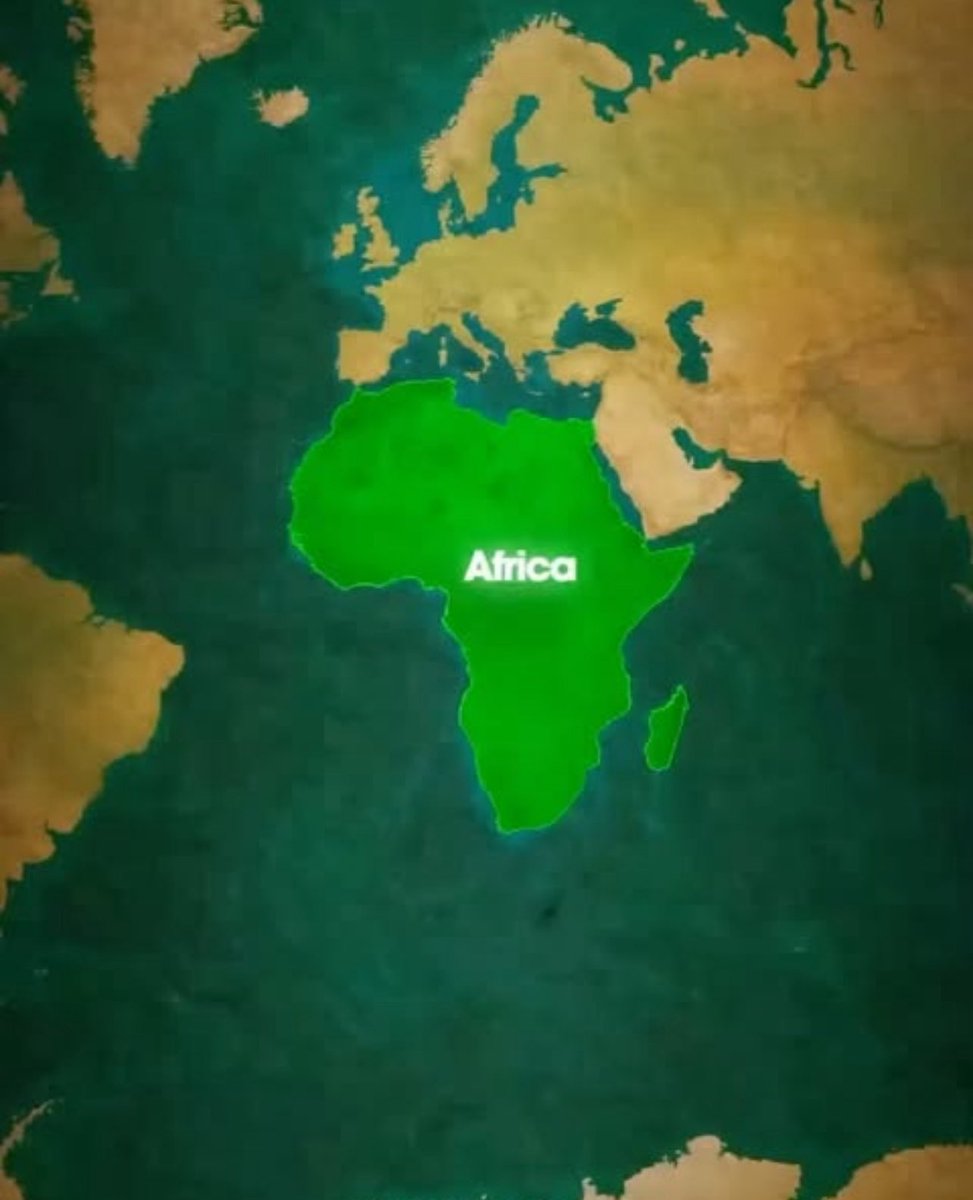
Google Maps and similar projections do not define Somalia’s real size or history. Mapping itself has long been a political tool. The same distorted projections shrink Africa while making North and South America, Russia, and China appear comparable; when Africa alone is larger than all of them combined.
History did not begin with colonization, and truth does not start with Google Maps.,The true size of Somalia is far greater than what today’s maps suggest. Reality deserves to be acknowledged. 🇸🇴✊🏽 #Somalia #Mogadishu #GreaterSomalia #Somali #SomaliUnity #OnePeople #PanSomali #AfricanHistory #DecolonizeMaps #ColonialBorders #ReclaimHistory #ColonialLegacy #ImperialMaps #maps #DecolonizeAfrica #TruthOverMaps #AfricanTruth #HistoryMatters #SomaliPride #FivePointStar #SomaliNation #SomaliPeninsula
46
82
629
21,697

19 Aug 2025
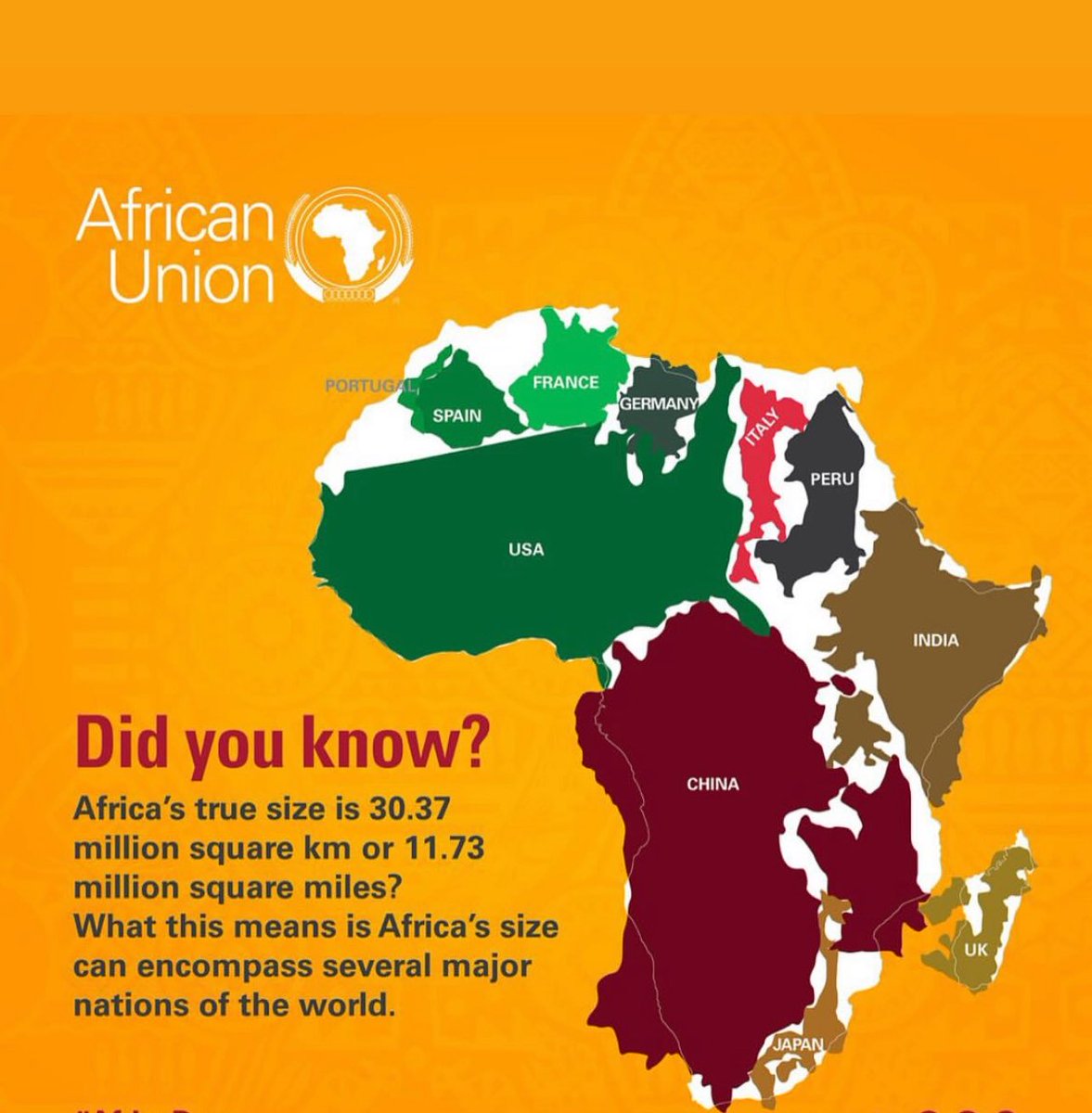
L’Union Africaine veut remplacer la vieille carte de Mercator qui réduit la taille de l’Afrique. En réalité, l’Afrique fait 30,37 millions km², soit assez grand pour contenir les USA 🇺🇸 , la Chine 🇨🇳 , l’Inde 🇮🇳 , le Japon 🇯🇵 , le Royaume-Uni 🇬🇧 , la France 🇫🇷 , l’Allemagne 🇩🇪 , l’Italie 🇮🇹 , l’Espagne 🇪🇸 et le Pérou réunis.
Et l’ objectif : montrer la vraie grandeur de l’Afrique, Changer la vision des cartes qui avantagent l’Europe et apprendre aux élèves une image plus juste de l’Afrique.
#AfricaTrueSize #DecolonizeMaps

1
4
334

4 Jun 2025
Do you know that Africa is HUGE and it's bigger than the US, China, India & most of Europe combined.?
Real no
Western cartographic manipulation and maps shrink it on purpose.
it’s a legacy of colonial lies. #Africa #MapTruth #DecolonizeMaps 🌍✊🏾

1
2
164


28 May 2019
The power of Indigenous Geographers #mapsarepolitical
#decolonizemaps
“ More indigenous territory has been claimed by maps than by guns. This assertion has its corollary: more indigenous territory can be defended and reclaimed by maps than by guns.”
medium.com/langscape-magazin…
16
29
30 Oct 2018
Indigenous names of Africa #decolonizemaps #indigenousplacenames #decolonizeafrica decolonialatlas.wordpress.co…

27 Jun 2017
3
2