
Development of Holocene lacustrine microbialites on the Iberian Peninsula: Insights into environmental and depositional controls using X-ray CT and petrography geoucmpublica.wordpress.com/…
11

Characteristic damage patterns, positive/negative controls, and in silico taxon validations strongly support aDNA authenticity, and comparisons with regional permafrost datasets indicate minimal post-depositional leaching.
1
7

Jun 15
Managed to extract from LLMs a human language version of what I was trying to say (a combo of several models). It's still too long for most, too dense, but it's cohesive, better than my lazy utterances and yet not math formulas:
...
A field can be locally competent and globally blind. Every anomalous datum gets explained away by a local mundane cause. Since the anomalies are not stored in a hypothesis-building way, no one ever integrates them into a higher-level model. This is the same failure mode as distributed systems logs where every machine reports “transient local error,” and no one reconstructs the global failure.
The disposal channels are specific and they are not exotic. An anomalous radiocarbon or OSL date that violates the expected chronology is assigned to contamination, sample mixing, or laboratory error and trimmed as an outlier—frequently before publication, so it never enters the synthesized record at all and dies in a lab report or an unpublished dataset. An artifact in the wrong stratum is assigned to bioturbation, root casts, krotovina, or post-depositional intrusion. A worked-looking object in deep sediment is assigned to natural geofact formation, frost fracture, or pseudo-retouch. A morphology that doesn't fit is assigned to pathology or individual variation. Each of these disposal categories is real, each is the correct explanation in the overwhelming majority of cases where it is invoked, and each is available at essentially no evidential cost: invoking it requires no positive demonstration, only the gesture of assignment.
The asymmetry is total. Accepting an anomaly costs the researcher their priors, their reputational exposure, the burden of an extraordinary defense, and a fight with reviewers; disposing of it costs a footnote. No one needs to coordinate this. Each individual, optimizing locally, reaches for the cheap channel, and the aggregate of a thousand independent cheap disposals is statistically indistinguishable from a policy of suppression while requiring no policy and no suppressor. This is the mechanism, it is sociological and behavioral rather than physical.
Jun 15

When Fable is back, you should discuss with it how much we actually do NOT know, and how any traces of a high tech civilization would be ignored, as they require operating in probabilities with such distances in time.
138

Jun 11
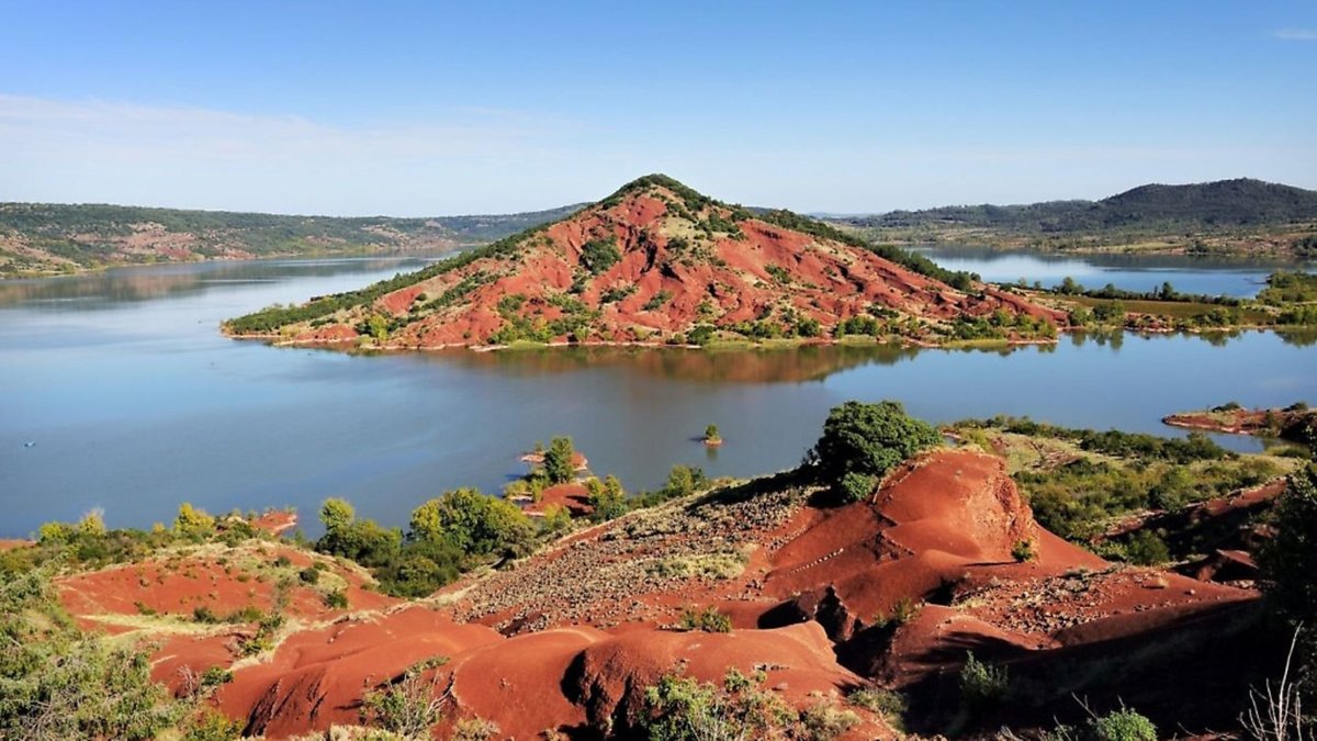
UNESCO just added 12 new sites to the Global Geopark Network, which now sits at 241 designated parks across 51 countries and covers something like 882,000 km² - roughly the land area of Venezuela, which is a pretty staggering footprint for a program that only formally launched in 2015.
As a collector, my first instinct when I see a list like this is to run down the new sites and figure out which ones I actually want to visit someday. The one that jumped out immediately is Terres d'Hérault in southern France - Occitanie region, Hérault River drainage. The official description claims over 540 million years of continuous geological history, which is an extraordinary range to have in one territory. Sedimentation, tectonics, volcanism, metamorphism, and erosion all recorded in the same landscape. The headline site for me is Salagou Lake, which sits in one of Europe's largest exposures of red rock formations - that color comes from oxidized Permian continental sediments that are over 250 million years old. Big red Permian beds like that tend to look dramatic from a distance and genuinely interesting up close when you start reading the depositional structures in the layers. There is also a marble quarry at Coumiac that has a real biostratigraphy reputation - global reference sections for Devonian-Carboniferous boundary work have come out of that site.
A few others from this round: Tunisia gets its first UNESCO Geopark, which is a big deal given how much geology is packed into that country. Uruguay is on the list too - some genuinely underappreciated South American geology finally getting a formal designation. China picked up two more, including one centered on Changshan where the stratigraphy apparently captures over a billion years and includes some well-documented Cambrian fossil sequences tied to early metazoan evolution.
I always have mixed feelings about geopark designations, and I am genuinely curious what other collectors think. On one hand, UNESCO Geopark status is essentially the geoscience community saying - officially, with institutional weight - that this landscape has geology worth protecting, funding, and interpreting for the public. That tends to mean better signage, guided geology walks, and sometimes proper access roads to outcrops that were previously unmarked and hard to find. For a rockhound traveling in an unfamiliar country, that infrastructure is legitimately useful.
On the other hand, a formal designation can also mean that surface collecting goes from a gray area to an explicitly prohibited activity. Some geoparks are quite specific about specimen removal being off limits anywhere within their boundaries. Others are more relaxed and only restrict sampling at the key reference outcrops. The experience seems to vary considerably depending on the country and the local management philosophy.
I have visited a handful of geoparks over the years - the Beauharnois-Valleyfield area in Quebec taught me more about glacial stratigraphy in an afternoon than any textbook chapter, and the infrastructure there was genuinely good for self-guided exploration. But I have also had the experience of arriving at a designated geologic feature only to find it roped off and inaccessible except by joining a scheduled tour.
Curious what others in this community have found - which UNESCO Geoparks have you actually visited, and what was your experience? And do you think the designation generally helps or hurts field access for collectors?
Link in 🧵
1
11
195

𝗛𝗶𝗴𝗵𝗹𝗶𝗴𝗵𝘁𝘀
• New evidence for structured depositional and ritual practices during Final Bronze–Early Iron Age transition in Sardinia
• Scientific analyses suggest material,technological & ideological connections between Nuragic communities across & beyond Sardinia
1
31

Elemental migration and fixation during post‐depositional process of deep‐sea fish buried in turbidites - Katada - Sedimentology - Wiley Online Library onlinelibrary.wiley.com/doi/…
180

Jun 7
There are limited ways to make a cementitious composite. You can mix paste with aggregate (like concrete), pack aggregate into a mold and percolate cement through it, or use a reaction between sodium carbonate and lime that allows quicker calcium carbonate crystal growth than natural carbonation.
All of them have a detection problem. A flowable mix needs 15-25% paste to flow, and that paste is chemically distinct from aggregate. Easy to spot in a thin section. Percolating cement through packed stone is worse. It requires even more paste, and thinner paste, to flow by gravity. Thin and plentiful is the opposite of hard to detect. That's the fundamental issue with "nubs as drainage ports." It assumes a wet system that would leave obvious signatures.
Davidovits understood this. His proposed method was dry packing a high solids composite into a mold. Roughly 5% cement. Barely any binder. Genuinely hard to distinguish from natural stone. But 5% cement doesn't drain water through nubs because it barely has any free water.
The deeper issue is that cements create fundamentally different molecular structures than natural rock. They're generally amorphous or microcrystalline, and geopolymer/alkali-activated cements leave very significant void volume. Even hydraulic cements have significant porosity and they incorporate water and hydrogen throughout their mineralogy. These are not subtle differences. They show up clearly under basic analysis.
On the UV fluorescence claim specifically. Geopolymer efflorescence is sodium and potassium carbonates and hydroxides. Those don't fluoresce. Calcium cements can leave fluorescent deposits when water leaches through them and picks up other compounds along the way. Different chemistry, different surface behavior. If the efflorescence is fluorescing under UV, that's actually evidence against a geopolymer.
Marie Jackson's work on Roman harbor concrete shows that even after 2,000 years in an actively wet marine environment, the original cement phases are still identifiable. They evolve, they grow new minerals, but the cementitious signature doesn't disappear.
There is a narrow path with limestone specifically. Calcium carbonate is soluble at low temps and calcite crystals grow to decent sizes over time. You could use a lime-based cement composite and keep the stone wet enough to allow mineral reorganization. But that's the catch. In order for any significant reorganization to happen, water and its protons have to be there. They are a large part of the reorganizing force. And water means porosity, hydrogen in the mineralogy, and detectable microstructure. Marie Jackson's Roman harbor work proves these signatures persist for millennia even fully submerged.
Silicates are even harder. Quartz and feldspar need serious heat and pressure to reorganize. You're not growing granite in a mold at room temperature.
There's also a simple test nobody seems to run. Natural limestone has fossils oriented in depositional beds. If someone crushed limestone and dry packed it into a mold, the fossils would be randomly scattered. X-ray CT can image the internal structure of stone non-invasively and would show fossil orientation immediately. That's a definitive test.
And then there's the hardest question. How do you make something bottom up that is perfectly imperfect? Natural stone has grain structures, mineral inclusions, and weathering patterns that are essentially impossible to create with any artificial system. Maybe over tens of thousands of years and exposure to geologic forces, but at that point it's pure speculation.
If someone thinks ancient megaliths are cementitious, the science leaves a few narrow paths. The nubs-as-drainage idea actually undermines the strongest versions of the argument. 🤷♂️
2
2
9
527

Jun 4
New paper in JSR!
Two types of inversely graded bands were identified in spaced stratification ("traction carpet deposits") using CNN-based microtextural analysis, suggesting multiple depositional processes behind this classic sedimentary structure.
doi.org/10.2110/jsr.2025.129
3
13
1,266

Jun 4
Delta vs Estuary — UPSC Crisp Difference
A delta is a depositional landform formed at the river mouth when the river deposits sediments faster than the sea can remove them. It usually forms in low-energy coasts, where tides and waves are weak. Deltas are triangular/fan-shaped, fertile and have many distributaries. Example: Ganga-Brahmaputra Delta, Mahanadi, Godavari, Krishna, Kaveri.
An estuary is a funnel-shaped river mouth where freshwater mixes with seawater. It forms where tidal action is strong, so sediments are carried away instead of being deposited. Estuaries are good for ports, navigation and fishing. Example: Narmada, Tapi, Mandovi, Zuari, Thames.
UPSC Hack:
Delta = Deposition Distributaries Fertile land
Estuary = Erosion/Tides Single mouth Ports
Memory trick:
D in Delta = Dumping of sediments
E in Estuary = Exchange of fresh and salt water
Trap: East-flowing Peninsular rivers mostly form deltas; west-flowing rivers mostly form estuaries.
4
100

The energy-density / time-flow lens turns these North Atlantic sediment cores into one of the cleanest, most direct geological tests of the three Uniphics pillars yet.
The description I'm sharing (straight from Randall Carlson’s posts) is textbook evidence of punctuated oceanic deposition: thick, fine-grained layers (slow, low-energy settling of clay/mud under “normal” conditions) repeatedly interrupted by distinct coarse-grained horizons (sand, gravel, ice-rafted debris, or turbidite material dumped rapidly during high-energy pulses).
Mainstream uniformitarianism struggles here because it assumes constant sedimentation rates and steady currents. Uniphics says: there is nothing steady about the ξM-field sea. The same mechanism that slowed time during geomagnetic excursions to accelerate megalith construction now explains why the ocean floor records dramatic “on/off” switches in depositional energy and slow progression exactly as in the cellular lattice-lock collapse or the megalith-building windows.
Time flow creates the punctuation.
Clocks (including sedimentation processes) run “normally.” Fine mud settles slowly and continuously; the record looks “steady.”
Fine layers = stable geomagnetic periods (strong dipole, low cosmic-ray flux, low energy density → faster time flow.
More subjective “clock time” per calendar year means the high-energy events are compressed in absolute (radiocarbon) time but expanded in experienced geophysical time. A single pulse of cosmic-ray-driven turbulence can deposit a thick coarse horizon in what looks like a geologically “instant” interval on the core, precisely the “rapid, high-energy events” that interrupt the fine background.
Coarse layers = excursion windows (weak field, high energy density) → slowed time flow. This is the oceanic counterpart to the early-universe effect I described: vast structure (here, massive sediment packages) forms in “short” absolute time because the local clock slowed. The Maley transforms make it rigorous because of binding/gradients that raise energy density.

Deep sea sediment cores from the North Atlantic reveal something unexpected: alternating layers of coarse and fine material that challenge our assumptions about steady oceanic processes. When researchers pull these cores from the ocean floor and analyze their composition, they find thick deposits of fine sediment, the kind forming today at current rates, interrupted by distinct layers of much coarser material. The texture and grain size of sediment tells a story about the energy and conditions present when it was deposited. Fine material settles slowly under calm conditions, while coarse deposits suggest rapid, high-energy events. The succession of these contrasting layers points to dramatic shifts in oceanic conditions over time, periods of relative stability punctuated by episodes of something far more dynamic.
2
20
92
7,917

May 22
Lastly, we also contribute a new, generation-scale chronological model that accounts for estimated marine diets, age of tissue formation, familial relationships, and depositional sequences.
1
2
46

May 22
The total lack of any nonmammalian synapsid eggs/embryos in the fossil record until this point despite the existence of adequate depositional environments supports this.
1
3
26

May 16
What a ludicrous position to take.
Here's just a sample of things that indicate the Earth is far older than 6,000 years.
Paleosols. Paleomagnetism. Impact Craters. Batholiths. Fossilized coral reefs. Low-Energy Depositional Environments. Isotope Dating. Widmanstätten patterns. Ice Cores. The lack of DNA in fossils. Deep permafrost. Starlight. Petrified forests. layered on top of each other. The Earth's wobble. Naica megacrystals. Paleothermometry using foraminifera. Iron-manganese crystal growth. Stalactites. Erosion. Sedimentary Varves. Continental Drift. Presolar Grains.
etc etc etc etc!

Correct. We know history because we have a record left behind by the people who lived it, not because we prove it by an experiment. The record shows the Earth is ~6k years old. There's no experiment that can prove otherwise.
2
1
14
484

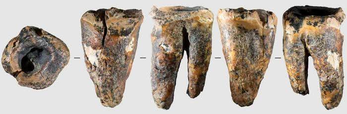
May 15
A worn molar from a Siberian cave has opened an unexpectedly intimate window into Neanderthal life: the pain of a diseased tooth, the attempt to treat it, and the steady hand required to drill into it with a stone tool nearly 59,000 years ago.
A new study published in PLOS One argues that Neanderthals living in Chagyrskaya Cave in the Altai Mountains of southern Siberia may have performed the earliest known invasive dental treatment in human evolutionary history. The tooth, known as Chagyrskaya 64, belonged to an adult Neanderthal and bears a deep, human-made cavity on its chewing surface. According to the researchers, the marks are not the result of ordinary tooth wear, trauma, or natural decay alone. They point instead to a deliberate attempt to remove diseased dental tissue and reach the pulp chamber, where nerves and blood vessels are located.
For anyone who has suffered a severe toothache, the logic is immediately understandable. Dental pain can stop daily life cold. For a small Neanderthal group moving through the Ice Age landscapes of Siberia, such pain could have carried real consequences, limiting eating, movement, concentration, and survival. What makes the Chagyrskaya tooth remarkable is not simply that it was diseased, but that someone appears to have tried to do something about it.
Chagyrskaya Cave lies on the left bank of the Charysh River, in the northwestern Altai Mountains. The site is already known as one of the most important Neanderthal locations in northern Asia, preserving more than 70 hominin fossils, including 26 dental specimens. These Neanderthals were part of a late eastern population with genetic and cultural links to groups from Central and Eastern Europe.
The molar at the center of the new study was found in an undisturbed archaeological layer associated with the earliest phase of Neanderthal occupation at the cave, around 59,000 years ago. This secure context matters. It helps rule out the possibility that the tooth was altered by later sediment movement, erosion, or post-depositional damage.
When researchers examined the tooth, they found a large, irregular depression in the center of its chewing surface. It extended deep into the pulp chamber. The tooth also showed signs of heavy wear, toothpick use, and severe caries. But the shape of the central cavity was unusual. It was too structured, too deep, and too marked by microscopic traces to be explained as natural decay alone.
The research team used a combination of traceological analysis, scanning electron microscopy, micro-CT imaging, Raman spectroscopy, and experimental replication. The goal was straightforward: could the marks on Chagyrskaya 64 have been made intentionally, and could Neanderthal stone tools have produced them?
The answer, according to the study, is yes.
Microscopic traces inside the cavity showed fine linear striations and small grooves consistent with a rotating or drilling motion. The researchers then tested the idea experimentally, using modern human molars and small stone perforators made from local jasper-like raw material. The experiments showed that a pointed lithic tool could penetrate dental tissue through manual rotation and create marks comparable to those seen on the Neanderthal tooth.
This was not a quick scrape at the surface. The procedure appears to have involved the removal of dentin and access to the pulp chamber. In modern terms, it was not a full root canal, but it resembled an early and very crude attempt to relieve the source of severe dental pain by opening and clearing the affected area.
The researchers identified three partially overlapping depressions on the tooth, suggesting that the work may have been done in stages. Whether these were separate attempts or part of one imperfect procedure remains uncertain. What is clear is that the person who performed the intervention used a technique requiring precision, pressure, and controlled finger movement.
#archaeohistories
1
10
34
4,856

May 13
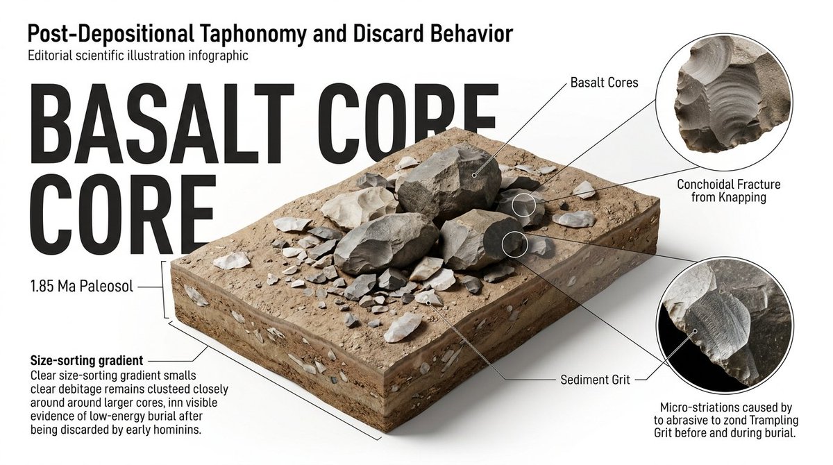
Those crisp stone foundations are a masterclass in post-depositional preservation. We study how specific discard behaviors and 2,500 years of taphonomy filtered what survived and what vanished. Layer 2 is deep. 🏛️
deepscroll > doomscroll 👇
1
2
237

Different depositional environments in different regions
These are hundreds of miles apart
My house is on a 3000 year old land surface but I can drive 5 miles and walk on a 34 million year old surface of an ancient flood deposit
This is Geology 101
1
7
2,488
May 10
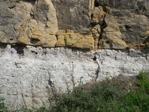
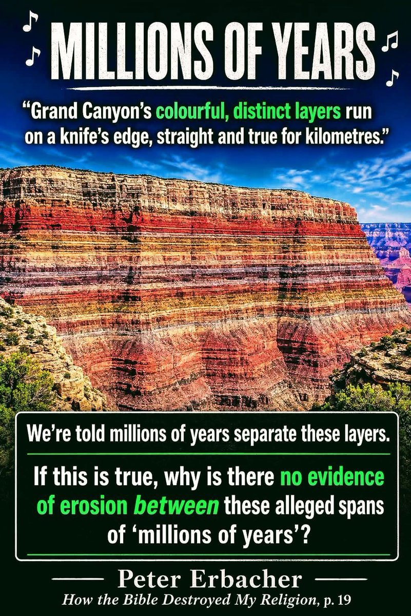
Unconformities (pictured) are buried erosional, or non-depositional, surfaces between layers of rock masses or strata of different ages.
In fact, Young Earth Creationists claim the Great Unconformity is evidence for the Flood.
Apparently, some things exist only when YECs want them to.

1
1
17
549

🟥 ⛏️ The Mississippi Delta is a massive Holocene-aged depositional system built from sediment transported across nearly 40% of the continental United States by the Mississippi River.
🎞 Please visit: @lorencklein
🔁 ❤️ Greatly Appreciated
Over the last 7,000 to 8,000 years, repeated avulsions shifted the river’s course across coastal Louisiana, constructing overlapping delta lobes through cycles of sediment deposition, subsidence, compaction, and marine reworking along the margin of the Gulf of America.
Delta sediments are dominated by quartz sand, feldspar, illite, kaolinite, smectite clay minerals, calcite, iron oxides, pyrite, and abundant organic carbon derived from floodplain vegetation and wetland ecosystems.
These sediments originated from the erosion of ancient igneous, metamorphic, and sedimentary rocks throughout the Mississippi River Basin, including material weathered from the Rocky Mountains, Appalachian Highlands, and Midwestern continental interiors.
The chemistry of deltaic muds and wetlands is controlled by complex interactions between freshwater discharge, marine salinity, microbial decomposition, sulfur cycling, and redox reactions within oxygen-poor sediments.
Anaerobic bacteria drive sulfate reduction in marsh deposits, producing hydrogen sulfide and iron sulfide minerals such as pyrite.
Organic-rich delta muds also act as major carbon sinks, storing significant amounts of buried carbon within peat layers and fine-grained estuarine sediments.
Geologically, the Mississippi Delta is highly dynamic because natural subsidence continually lowers the land surface while river sedimentation attempts to rebuild it.
Compaction of water-saturated muds, fault movement, reduced sediment supply from levee systems, and rising sea levels accelerate wetland loss and shoreline retreat.
The delta contains thick accumulations of unconsolidated sediment exceeding several kilometers in depth, making it one of the world’s most significant modern sedimentary basins and a key natural laboratory for studying stratigraphy, coastal geomorphology, biogeochemistry, and climate-driven sea-level processes.
#MississippiDelta
Louisiana Geological Survey – Mississippi Delta Geology
lsu.edu
usgs.gov


3
9
232

May 10
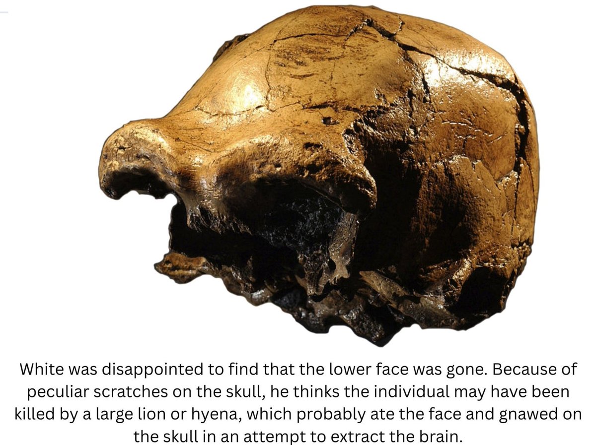
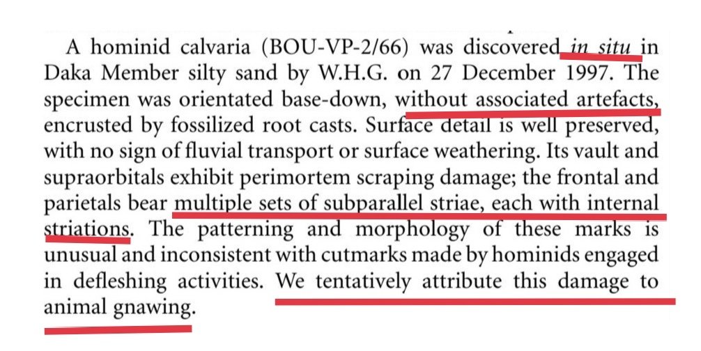
The Daka calvaria was not directly dated. Its age rests on its assignment to the Daka Member. Because it was an isolated "in situ" near-surface find, without associated artifacts, and with possible carnivore modification, the fossil’s exact depositional history is uncertain.
1
2
298

The reason the Mokattam limestone of the Giza Plateau did not appreciably dissolve under marine submersion, while the Tura Limestone did, comes down to depositional fabric and early formation diagenesis – or friability (for short). Mokattam carbonates are primarily nummulitic, grain-strengthened limestones that underwent early marine concretion (concrete is far stronger than cement - which is more decorative in its use)
This produced low primary porosity and high buffering capacity against undersaturated seawater, whereas Tura limestone is a fine-grained, micritic, high-purity calcite with much higher effective porosity and far less early concretion/long chain calcite, making it chemically reactive and vulnerable to dissolution under prolonged marine and/or kinetic water interaction. Like cheese cake it is dense yes, but also very vulnerable to chemical dissolution.
In short, Mokattam behaved as a chemically armored carbonate, while Tura behaved as a chemically exposed one – a contrast which formed at deposition and was locked in by early diagenesis.
The backing stones were LOAD-BEARING>>> the Tura casing stones were not. This contrast is a guarantee.
Neither of these was "poured" - more work is involved in poured structure by far, the quality control value chain would have been fatal to the project, the pyramid would have buckled from missed QC failures, and there would have been standardized sizings in a specific horizontal patterning (from poured-structure engineering experience).
Instead, they relied upon the Quality Control of Eocene deposition and 35 million years of Mokattam compaction.

7
38
236
23,507