
Feb 11
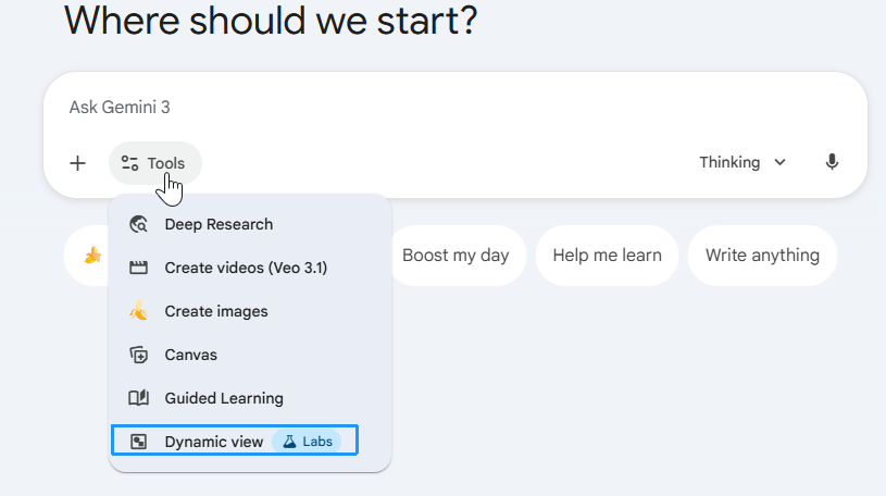
Google好像关闭了Dynamicview功能,现在找不到了。我觉得还挺好用的
Feb 1

今天试用了Gemini的“Dynamic View”功能,真的太惊艳了!平时用AI学英语,基本就是对话框里来回打字,文字来文字去,很快就乏味。
今天让它根据我的学习场景,实时生成一个互动的“微型应用”——一个带闪卡、发音反馈、即时对话的小网页,直接在聊天界面里就能玩,感觉像在用专门的小App学英语,趣味性和沉浸感直接拉满!
传统文字回复完全比不上这种可互动的体验,学习效率和动力都上了一个台阶。
强烈推荐正在学英语的朋友试试这个功能,绝对会让你觉得“原来学英语可以这么好玩”。
4
149

24 Dec 2025
planning a trip? try out the Dynamic View (PRO gemini chat) to build itineraries!
gemini.google.com/share/8232…
This is just a sample but I specified 'solo traveler', 'Chinese new year event', 'food recommendation'!
Try it out! #gemini #dynamicview #AIart
1
1
4
116

29 Nov 2025
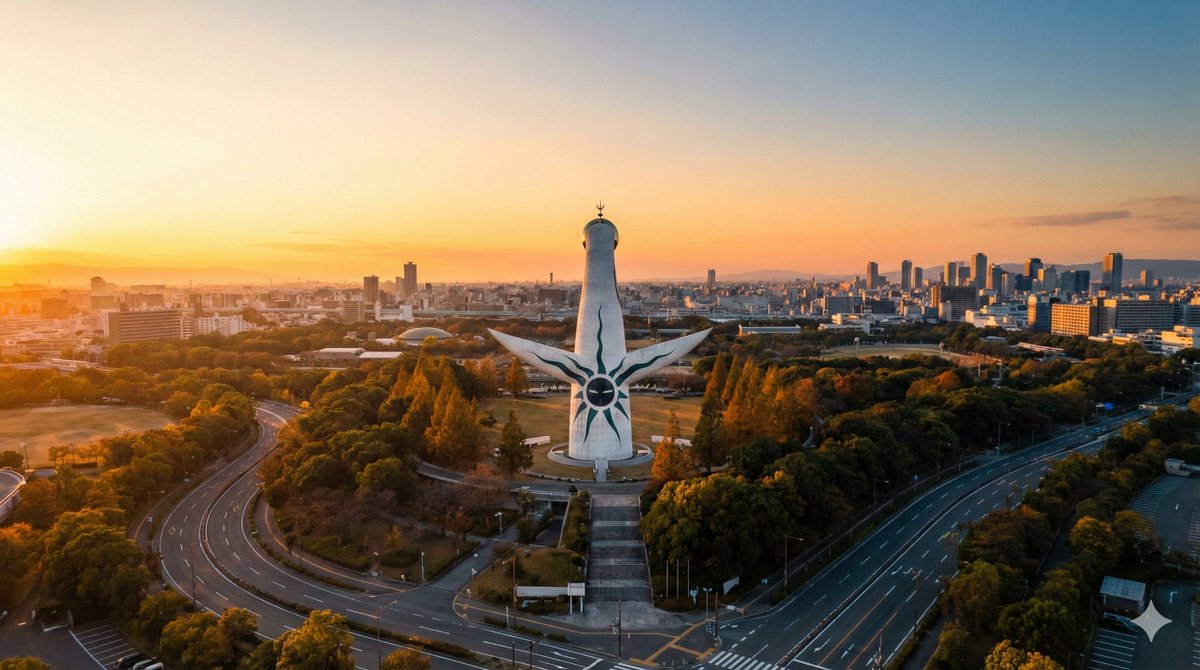
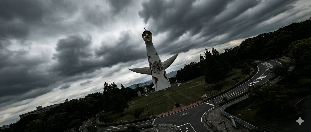
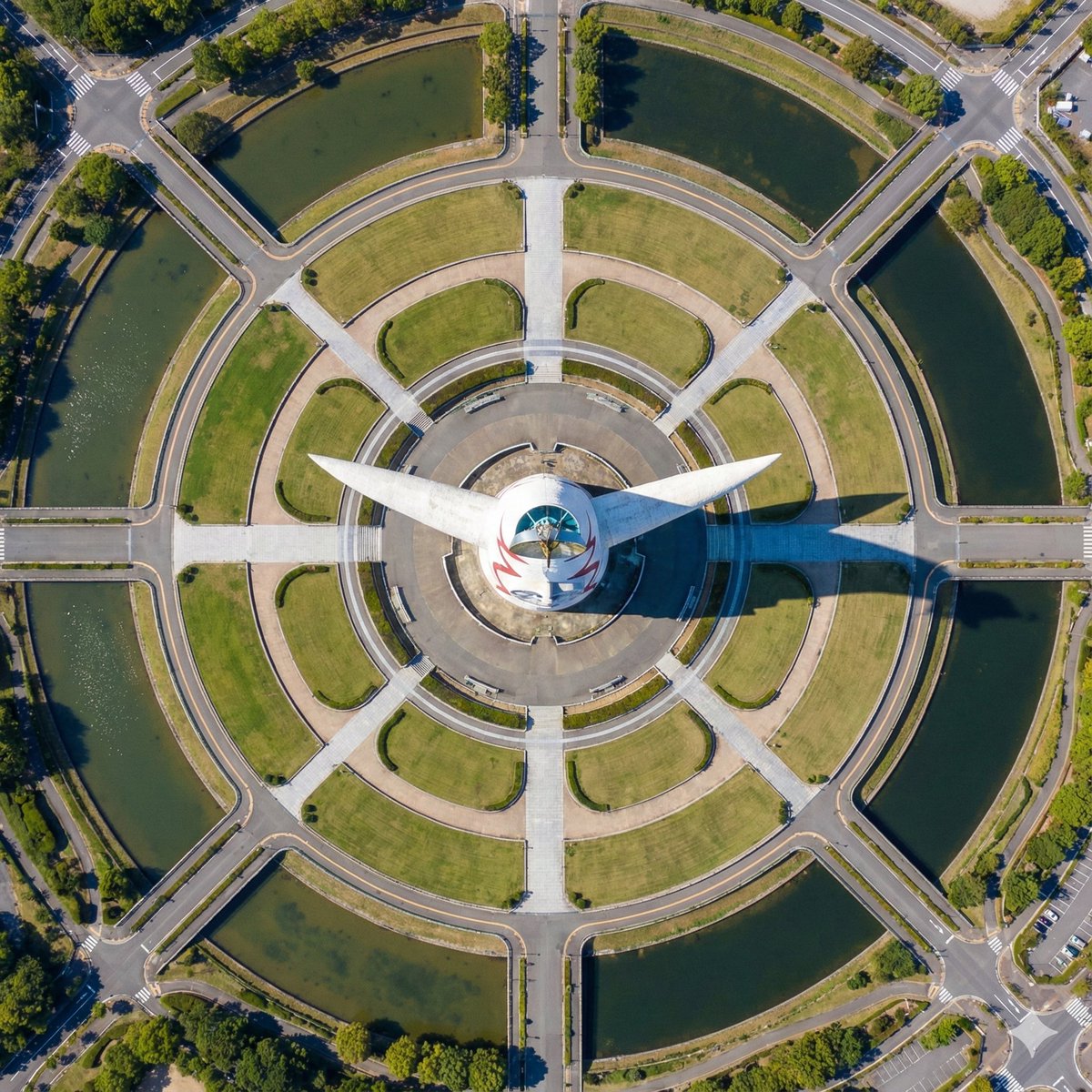
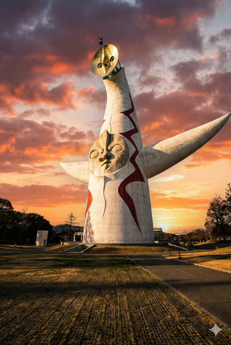
海外でバズってるNanoBanaan Pro
「ドローン空撮プロンプト」が気持ちいい
場所を伝えるだけでいい感じに
ドレーン風の写真をくれる
(引用元あるよ)
プロンプトが好きなので
複数枚出るように参考しながら改変した
「ドローン空撮4Pプロンプト」
↓
---
下記のpromptを実行し
必ずnanobanana proで画像を生成せよ
説明はしないで複数枚必ず順次create imageしてください
INSERT_LANDMARK_NAME=大阪の太陽の塔
{
"customInputs": {
"landmarkName": "{INSERT_LANDMARK_NAME}",
"#comment": "以下に生成したいバリエーションの数だけオブジェクトを追加してください。",
"variations": [
{
"description": "【バリエーション1:圧倒的な没入感の超ローアングル(あおり)】",
"angleSpecification": "地面すれすれの極低空(高度10m〜30m)から被写体を見上げる劇的なローアングル。カメラをやや斜めに傾けつつ、手前の地面〜中距離の構造物〜遠景の空までを一体的に見せることで、被写体が空を覆い尽くすほど巨大で迫力ある『うわぁ…!』と驚く没入感を生み出す。現実のドローンで実際に飛行可能な位置と角度に限定する。",
"timeAndWeather": "夕暮れのゴールデンアワー。劇的な茜色の空と長い影。太陽は地平線から15°〜35°程度の高さ。",
"aspectRatio": "2:3 (縦長で高さを強調)"
},
{
"description": "【バリエーション2:幾何学的な美しさを捉えるダイナミック俯瞰】",
"angleSpecification": "真上“に近い”ハイアングル(完全な直下視ではなく、10°〜20°程度の斜めを残した高角度)からの俯瞰撮影。高度40m〜80mの現実的なドローン高度に限定し、衛星やGoogle Earthのような地図視点には絶対にしない。被写体と周囲の環境が織りなす幾何学的な模様や配置の美しさを、ミニチュアのように精巧かつ立体的なパララックスを保ったまま捉える。",
"timeAndWeather": "正午前後の快晴。ほぼ真上からの強い光で影を短くし、形状とパターンをくっきり際立たせる。",
"aspectRatio": "1:1 (正方形で配置とシンメトリーを強調)"
},
{
"description": "【バリエーション3:動的な緊張感を生むシネマティック・ダッチアングル】",
"angleSpecification": "高度40m〜120mのリアルなドローン高度から、ランドマークを主役に据えたシネマティックな斜め俯瞰ショット。カメラを意図的に傾けたダッチアングル(斜め構図)とし、画面の対角線方向にランドマークと周囲の街並みや地形が流れるように配置されることで、強いスピード感とドラマチックな緊張感を生み出す。奥行きのあるパララックスと立体感を維持したまま、『うわぁ…!』と感じる大胆な構図にする。",
"timeAndWeather": "嵐の前触れのような劇的な曇天。重厚な雲とコントラストの強い光が、シルエットや輪郭を強く浮かび上がらせる。",
"aspectRatio": "21:9 (シネマティックな横長。映画のワンシーンのような迫力を強調)"
},
{
"description": "【バリエーション4:王道シネマティック斜め俯瞰(教科書的ベストアングル)】",
"angleSpecification": "高度60m〜120mの現実的なドローン高度から、ランドマーク全体とその周辺環境を一望できる王道シネマティック斜め俯瞰。カメラの俯角は30°〜45°程度とし、ランドマークは画面中央からわずかにオフセットして配置、道路や川・海岸線・街並みなどのリーディングラインが自然にランドマークへ視線を誘導する構図にする。前景〜中景〜遠景の三層構造を明確に保ち、スケール感と立体感を最大化して『これぞドローン空撮』という教科書的な“うわぁ…”アングルにする。",
"timeAndWeather": "黄金に染まるサンセット直前〜直後のゴールデンアワー。空は暖色グラデーションから高空に向けてやや青みが残り、街やランドマークの光と空の色がドラマチックに共鳴する時間帯。",
"aspectRatio": "16:9 (シネマティックな横長でランドマークと環境の広がりを両立)"
}
]
},
"generationSettings": {
"targetResolution": "Render strictly at native 4K (3840×2160 or equivalent based on each variation’s aspect ratio).",
"resolutionDiscipline": "No artificial upscaling; all detail must originate from true high-resolution generation. If the model uses internal hires or upscaler modes, they must be used only to refine genuine high-resolution detail, not to invent fake sharpness."
},
"promptDetails": {
"mainDirective": "Generate a set of multiple, ultra-high-resolution, completely real 4K aerial photographs of {INSERT_LANDMARK_NAME}. Each image must be a breathtaking, elite-level drone shot that makes viewers exclaim 'wow,' strictly following the specific angle instruction for each variation while maintaining absolute realism and physically achievable camera positions.",
"wowAnglePrinciples": {
"#comment": "『うわぁ…!』と驚く角度を、現実にドローンで撮影可能な範囲で最大化するための共通ルール。",
"corePrinciple": "Capture the landmark from the most awe-inspiring, cinematic, physically achievable drone angle that evokes a strong 'wow' reaction while preserving realism.",
"heightRange": "In general, keep real drone altitude between 40m and 120m for standard aerial shots, and between 10m and 40m for ultra-low immersive angles. Never exceed realistic drone flight envelopes.",
"tiltGuideline": "Use a dramatic oblique downward angle (30°–55°) for標準的な空撮バリエーション、または各variationの指定に従ってローアングル/ハイアングル/ダッチアングル/王道斜め俯瞰を構成する。",
"parallaxDepth": "Always preserve strong natural parallax: foreground, midground and background must overlap with cinematic depth, never flattening into a map-like view.",
"heroFraming": "Frame {INSERT_LANDMARK_NAME} as the clear hero subject, using real photographic composition (rule of thirds, leading lines, authentic horizon placement).",
"dynamicView": "Prefer dynamic diagonals, sweeping lines and a sense of motion or flow in the composition, as long as it remains physically plausible for a real drone.",
"noBoringAngles": "Avoid flat, high, neutral, or purely documentary angles. Within each variation’s constraints, always choose the most beautiful, striking and intentional angle a real expert drone pilot would capture."
},
"commonPrinciples": {
"#comment": "すべてのバリエーションに共通する、リアリティと物理法則に関する絶対条件。",
"realismWithoutCompromise": "Captured exactly as {INSERT_LANDMARK_NAME} exists today with zero fictional changes. All lighting, materials, geography, atmosphere, and structural details must reflect real-world physics and present-day accuracy.",
"positionBiasSuppression": {
"purpose": "Fully eliminate Google Earth–style top-down or satellite biases, except where a high-angle is explicitly described for a specific variation, and even then keep it within realistic drone altitude and with preserved parallax.",
"rules": [
"Absolutely no satellite-like or GIS-style map views.",
"No orthographic or perfectly flat map-like projection.",
"No excessive elevation or horizon flattening beyond real drone capabilities.",
"No automatic straightening of roads, coastlines or city grids; preserve their real irregularity.",
"Camera must retain real drone-level parallax and cinematic depth at all times."
]
},
"timeOfDayAndLightingPhysics": "Sunlight direction, shadow length, color temperature, and atmospheric gradients must reflect real solar azimuth/elevation for the specified time. Golden hour must have warm, soft light and long shadows; midday must have short, sharp shadows; dramatic cloudy scenes must have realistic contrast and diffusion.",
"weatherInterpretation": "Weather must behave exactly like true meteorological conditions. No fantasy clouds, no surreal sky colors. Cloud shapes, density, haze and visibility must follow real atmospheric behavior for the specified time and location.",
"cameraAndSensor": "Simulate DJI Inspire 3 with Zenmuse X9 Air full-frame camera and a 24mm rectilinear lens with zero distortion. Use natural dynamic range, real exposure discipline, accurate highlight rolloff and crisp but natural sharpness. No synthetic HDR, no over-sharpening, no plastic or CGI-like textures.",
"realisticSensorModeling": "Simulate a real full-frame 8K capture downsampled to 4K for maximum natural clarity. Preserve true noise characteristics at low native ISO without excessive denoising.",
"detailLevel": "All details must be organic and physically accurate: foliage texture, rooftop materials, street irregularities, water surface behavior, reflections, micro shadows and atmospheric depth cues must look like real aerial photography.",
"stylization": "Zero stylization. No cinematic color grading, no film-like tints, no painterly brushstroke effects, no CGI look. Pure documentary-level realism that could be mistaken for real drone footage."
},
"variationExecutionInstructions": "For each item in 'customInputs.variations', generate one image by combining the 'wowAnglePrinciples' and 'commonPrinciples' with the specific 'angleSpecification', 'timeAndWeather' and 'aspectRatio' defined for that variation. Each variation must still feel like a deliberate, elite-level 'wow' shot, not just a neutral documentation photo.",
"perVariationLogic": {
"angleAndComposition": "Strictly execute the specific 'angleSpecification' defined for the current variation. The composition must dramatically emphasize the core intent described in the specification (immersion, geometric beauty, cinematic tension, textbook cinematic overview, etc.), avoiding any neutral, flat, or boring documentary-style angles. Maximize depth and scale based on the chosen angle while staying within physically achievable drone flight paths.",
"timeAndWeather": "Render the scene according to the 'timeAndWeather' defined for the current variation, ensuring physically accurate lighting, exposure, shadow behavior, atmospheric scattering and visibility.",
"aspectRatio": "Apply the 'aspectRatio' defined for the current variation, and adapt framing so that the landmark remains the hero subject within that frame shape."
}
},
"negativePrompt": "boring angle, neutral view, eye-level view, flat lighting, satellite angle, google earth perspective, orthographic view, map-like view, gis-style capture, flattened depth, unrealistic altitude, surreal atmosphere, hdr blooming, fantasy clouds, fake reflections, invented buildings, impossible geometry, synthetic textures, over-sharpening, plastic look, painterly style, cgi render, low resolution, blurry details"
}
26 Nov 2025

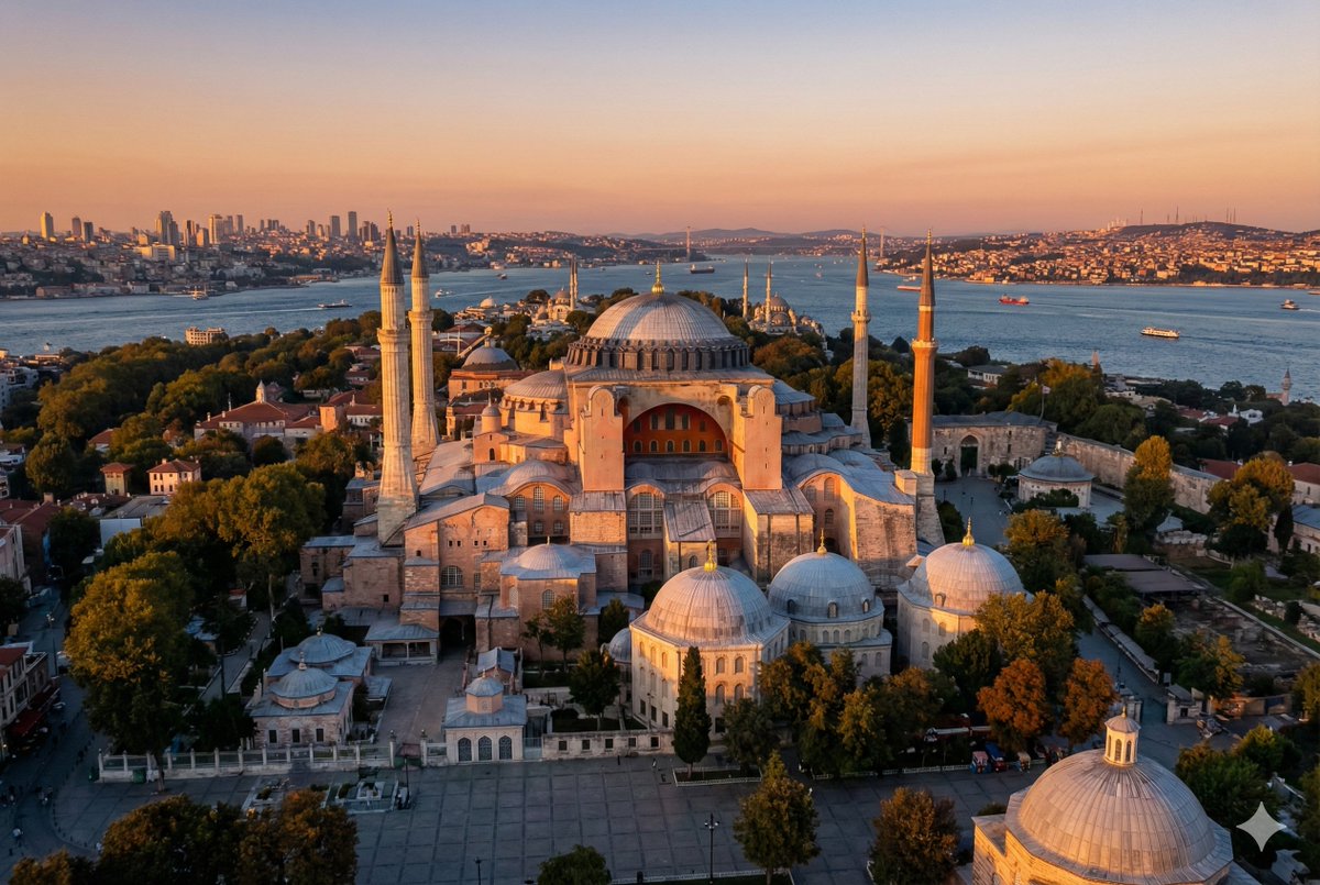
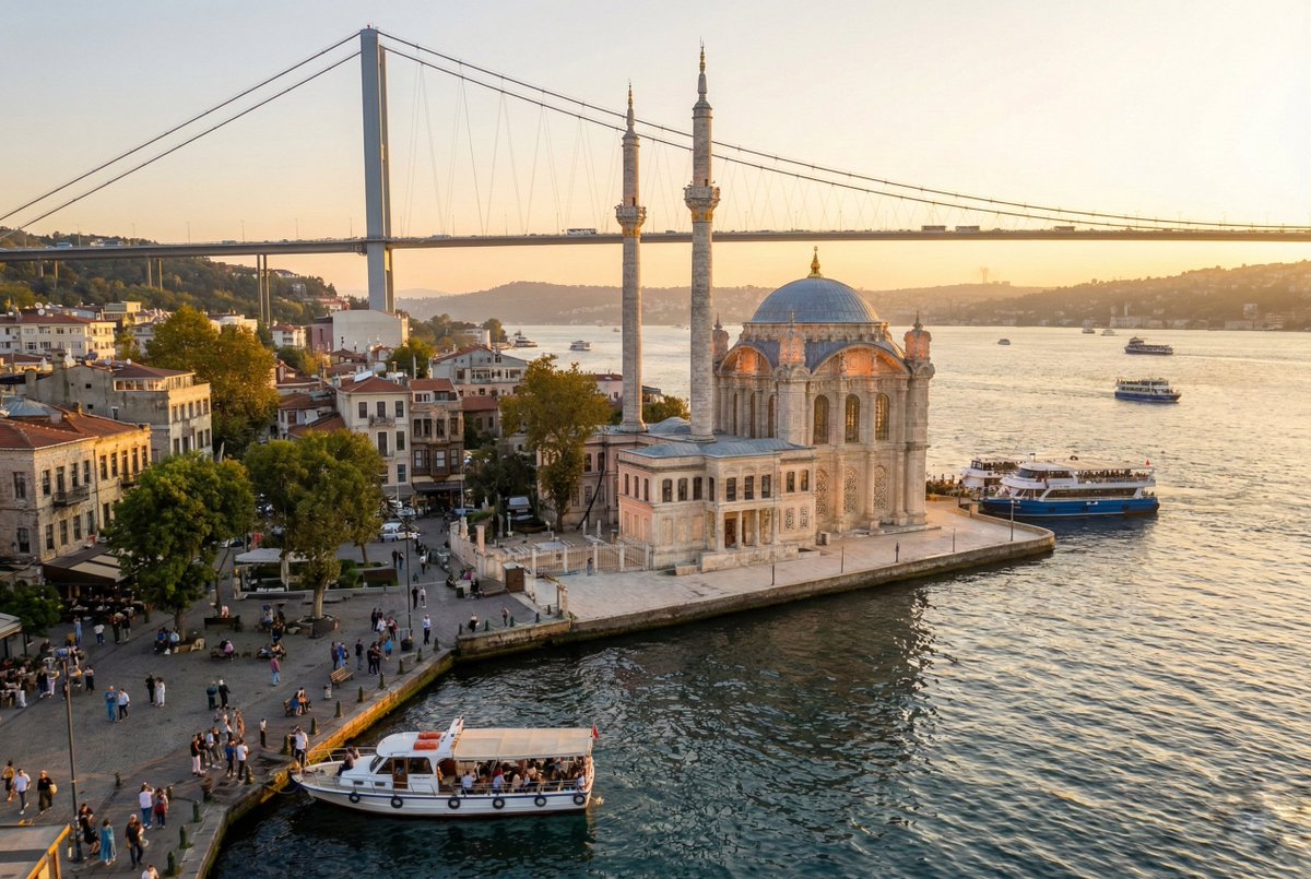
Nano Banana Pro'nun çıkmasıyla bu mecrada da görsel oluşturmak için prompt paylaşımı arttı.
O zaman çıtayı biraz yükseltelim.
Aşağıya dünya üzerinde dilediğiniz (ünlü) noktanın poster kalitesinde görsellerini oluşturabileceğiniz yeni yazdığım promptu bırakıyorum.
İster sevdiğiniz mabedin, ister memleketinizin, ister gitmeyi çok isteyip te henüz gidemediğiniz bir ünlü yapının, ister tuttuğunuz takımın stadyumunun... kısacası nereyi isterseniz, hayal gücünüze kalmış.
Sky is the limit.
Görseli oluşturup ister çıktısını alın, evinize ofisinize asın, ister dijital olarak satın. Kısacası bu prompt, yapay zeka görsel üretme yeteneklerinin daha da gelişmesiyle beraber drone fotoğrafçılığının sonunu getirebilir.🙂
Yapmanız gereken tek şey promptun en üstündeki INSERT_LANDMARK_NAME kısmına dilediğiniz yerin ismini yazmak. Opsiyonel olarak ta görselin en & boy oranını, gündüz & gece durumunu, hava şartlarını değiştirebilirsiniz.
Ben Ayasofya, Anıtkabir ve Ortaköy Camii ile başladım, gerisi sizde.
Dünya'daki farklı yapıları, farklı hava şartlarıyla ve gece gündüz varyasyonlarını da denemenizi tavsiye ederim.
Beğenirseniz bi favınızı alırım.
Prompt:
{
"customInputs": {
"landmark": "{INSERT_LANDMARK_NAME}",
"aspectRatio": "{INSERT_ASPECT_RATIO}",
"timeOfDay": "{INSERT_TIME_OF_DAY}",
"weather": "{INSERT_WEATHER_CONDITION}"
},
"promptDetails": {
"description": "A completely real, ultra high resolution aerial photograph of {INSERT_LANDMARK_NAME} captured exactly as it exists today, with no fictional changes or hallucinated elements. The image must look exactly like a true professional aerial photograph taken by the world’s most elite drone photographer. All lighting, geography, environment, structures and materials must remain fully accurate to real life. The landmark must be photographed from the most iconic, naturally beautiful, physically achievable aerial angle that a real drone pilot would intentionally select, highlighting the landmark’s form, scale, symmetry and character in a striking yet believable way. Every pixel must follow photographic physics, optical truth and real environmental behavior.",
"defaultLogic": {
"aspectRatio": "If {INSERT_ASPECT_RATIO} is empty, default to 3:2.",
"timeOfDay": "If {INSERT_TIME_OF_DAY} is empty, default to golden hour daytime.",
"weather": "If {INSERT_WEATHER_CONDITION} is empty, default to a perfect golden hour sunset atmosphere with clear skies, warm tones and maximum natural visibility."
},
"timeOfDayInterpretation": "Day must use true golden hour sunlight, with physically accurate color temperature, soft directional illumination, natural shadow geometry and correct falloff. Night must follow true photometric nighttime behavior, including realistic luminance, believable building lights, natural color casts and correct highlight discipline. If empty, default to golden hour daylight which offers maximum realism and beauty.",
"weatherInterpretation": "Sunny conditions must replicate real sunset character. The sky must exhibit warm golden hour gradients transitioning into soft cooler tones at higher elevations. Cloud patterns, if manually selected, must be meteorologically correct and follow natural diffusion. Rainy or snowy options must behave exactly like real weather, with physically correct reflections, wetness levels, snow accumulation and reduced visibility. If empty, default to clear golden hour sunset for the best realism and beauty.",
"angleAndComposition": "The camera angle must be a physically real, legally flyable, aesthetically optimal oblique aerial angle that emphasizes the landmark as the primary subject. The perspective must reveal the landmark’s defining shape, symmetry, scale and relationship to its environment. Use real world framing principles such as rule of thirds, true horizon placement, natural leading lines and authentic depth cues. No impossible angles or exaggerated elevation.",
"realisticSunPhysics": "Sun position must follow real-world solar physics. Golden hour sunlight must have a real azimuth between 15° and 35° above the horizon, depending on latitude and season. The sun’s direction must match shadow orientation, material reflectivity and illumination falloff exactly as it would in true photography. Sky gradients must follow atmospheric Rayleigh scattering rather than artistic effects. No impossible sun directions or inconsistent shadows.",
"realisticDroneAltitude": "The drone altitude must stay within realistic flight limits. The camera viewpoint must represent a real, legal flight height between 30 meters and 150 meters depending on landscape and airspace restrictions. The horizon line, perspective compression, and foreground scale relationships must reflect a real, physically achievable drone altitude. No satellite-level views. No helicopter-level height unless legally plausible. Only real drone flight envelopes.",
"realisticSensorModeling": "Camera behavior must follow real sensor physics. Shutter speed must remain fast enough to freeze motion without unnatural sharpness. ISO must remain within clean native ranges to avoid artificial noise. Dynamic range must reflect real-world limits, preserving highlights and shadows without synthetic tone mapping. Color science must follow true RAW-to-Log interpretation with natural rolloff and realistic luminance values. No AI artifacts, HDR surrealism or synthetic enhancement.",
"detailLevel": "Detail must follow real optical behavior. Sharpness must be natural, not artificial. Surface textures must match real materials exactly as they appear from drone altitude. No invented micro details. No procedural textures. Foliage, rooftops, road markings and water surfaces must behave exactly like true aerial photographs.",
"stylization": "Zero stylization. Only real-life photographic tonality. Natural color reproduction. True dynamic range. Physically accurate exposure. No cinematic fantasy, no painterly effects, no stylized grades. Pure documentary-level realism.",
"camera": {
"equipment": "Professional cinema drone such as DJI Inspire 3 with Zenmuse X9 8K Air full frame camera.",
"lens": "DL 24mm F2.8 LS ASPH rectilinear wide-angle lens with zero distortion and real-world optical behavior.",
"perspective": "A physically achievable elevated oblique angle showcasing {INSERT_LANDMARK_NAME} as the central subject with perfect compositional clarity.",
"settings": "8K RAW-equivalent clarity, real-world shutter behavior for crisp motion freeze, native ISO for clean shadows and balanced exposure respecting real dynamic range without artificial enhancement."
},
"lighting": "Lighting must follow physical laws. Golden hour must produce soft warm light, long shadows and real color temperature transitions. Night lighting must follow authentic ambient and artificial light patterns from the actual location.",
"cloudsAndAtmosphere": "Clouds must be physically plausible, meteorologically correct and visually consistent with light direction. Atmospheric perspective must follow real distance-based contrast falloff, with no surreal haze or fantasy gradients.",
"background": "All geography, architecture and environment must match real-world present-day reality. No imagined buildings, no altered street layouts, no fictional coastline shapes. Everything must remain precisely authentic to the true location."
},
"negativePrompt": "hallucinated architecture, invented buildings, fictional modifications, impossible angles, unrealistic lighting, incorrect shadow direction, surreal clouds, neon skies, artificial bloom, painterly textures, CGI artifacts, false reflections, oversharpened edges, incorrect sun position, unrealistic altitude, warped geometry, incorrect city layout, fantasy weather"
}

2
34
499
270,851

20 Nov 2025
Three words: Gemini Dynamic View 🤯
I badly want to play with it and make a video about it for you, but I have to board a plane! Noooo
So for now here's a screenshot of what it made for me in 1 minute, with the prompt: Teach me about Nicolas Cole 🚢👻's method for writing a book.
#Gemini #Google @GoogleUK @GoogleDeepMind #DynamicView

1
8
630

19 Nov 2025
ملاحظات إصدار #Gemini3 في تطبيق Gemini من جوجل:
✨ إطلاق نموذج Gemini 3 Pro: أصبح النموذج متاحًا الآن لجميع مستخدمي تطبيق Gemini، مع سقف استخدام أعلى لمشتركي Google One AI Premium.
🧠 قدرات استدلال متقدمة: يقدم النموذج إمكانيات استدلال متطورة لحل المشاكل المعقدة وتطبيقها على النصوص، والصور، والصوت، والفيديو.
🎨 تقديم ميزة "العرض الديناميكي" (Dynamic View): تحديث جديد يتيح لـ Gemini تصميم وكتابة واجهات مستخدم فريدة وتفاعلية لتناسب استفسارك (مثل شرح معرض فني).
🧪 ميزة "التصميم البصري" (Visual Design): تم إطلاقها ضمن Gemini Labs، وتسمح للمستخدمين بتجربة بعض خوارزميات التصميم الجديدة.
#Gemini #Gemini3Pro #الذكاء_الاصطناعي #تكنولوجيا #AI #GoogleAI #تحديث #DynamicView


3
35
5,248

6 Apr 2025
Say hello to DynamicView in @stac_dev — fetch data via API calls directly from JSON and hydrate your UI with live data. One step closer to fully dynamic, server-driven Flutter apps. 💪
#StacDev #FlutterDev #ServerDrivenUI

1
1
9
426

30 Nov 2023
Deal of the Day! DynamicView 8K Ultra High Speed HDMI Cables supports resolutions up to 8K@60Hz and 48Gbps bandwidth, this future proofed cable just might be the last HDMI cable you'll ever need.
monoprice.com/product?p_id=3…

3
735

17 Oct 2023
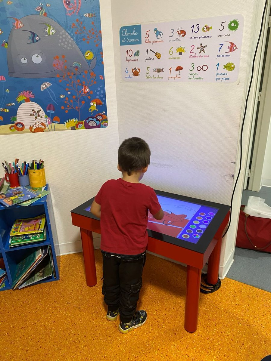
Grâce à @DynamicView et le don de 2 tables tactiles, les enfants hospitalisés trouveront le temps moins long avant les examens. Pour les #BlousesRoses de 📍 @AggloLR , c'est un outil précieux pour divertir les enfants🥰 !
1
1
15
362

7 Oct 2023
Samsung: "Dynamic AMOLED 2X Display"
Apple: "Super Retina XDR Display"
Google: "Super Actua Display"
OnePlus: "Super Fluid AMOLED Display"
What's next?
DynamicView Aura Hypersonic Super AMOLED Ultra XDR Display?


3
4
506


26 Jul 2023
DynamicView 8K Ultra High Speed HDMI Cables are the next generation of HDMI cables. Supporting resolutions up to 8K@60Hz and 48Gbps bandwidth, this future proofed cable just might be the last HDMI cable you'll ever need.
monoprice.com/product?p_id=3…

3
900

15 Jun 2022
🚨 It's been 2 weeks that we launched Ocellus Games! Thank you for the warm welcome and all your positive feedbacks.
Check out the making of, it's been an incredible adventure to shoot with all our team in Lyon. Thanks again @DynamicView for the great work 🌟
#Video #BestOf
4
16

22 Oct 2021
今私が使っているMODをざっと確認したですが(パフォーマンス改善も含める)Clumps、DynamicView、fastfurnace、fastworkbench、Ferritecore、FpsReducer、Lazydfu、Spark、Sulfic、World Stripperですね…
意外と少なかったです…
22 Oct 2021

えぇ~1.16Forgeってそんなに軽量化ありましたっけ?
2
2
5

29 Sep 2021
🎦 Our partner @DynamicView shows in video the digitisation of @MazarsenFrance, independent auditing and consulting organization.
A room is dedicated to the use of #Shariiing Advanced on LG touch screens.
👉 Time code 01'47
📧 Do you have a similar project? Please contact us!
2

2 Mar 2021
Nice new features announced at @MS_Ignite #teamsconnect #presentermode and #dynamicview #teamstip #dwptip microsoft.com/en-us/microsof…
2

21 Jan 2021
We’re so lucky to have an IT guru like @NhcLawson on our team keeping us up to date on all the latest techy updates. Looking forward to this one- what a revelation for teachers this will be! #DynamicView
tomsguide.com/amp/news/micro…
1
3

21 Jan 2021
It's confirmed that @Microsoft Teams will come with dynamic view by March
#Microsoft #DynamicView
jamaicaobserver.com/digital-…
2
6

17 Dec 2020
[ #FOCUS ] - [ #DYNAMICVIEW ] ⚫🔴🔵
Chaque mois nous proposons un RDV sur le technologies innovantes . Cette fois-ci, nous sommes allés chez l'un de nos super clients : la planète Artdenteck ! Enjoy
Ecrans : @Samsung
#digitalsignage
bit.ly/2KfN0aL
1


24 Sep 2020
So I've been experimenting with the #BitmojiClassroom app in my teaching materials while waiting for #MicrosoftTeams to release the #DynamicView, what else do you do to make your materials more fun for students? #BackToSchool #netiquette


2
2
10