Read all about it! The next Earthdata Discovery newsletter will be emailed the week of October 9. This is your chance to learn about new data resources, rewatch Earthdata webinars, and more.
Subscribe today: go.nasa.gov/3NdirQK#EarthDataEnablesScience
ALT 7-panel image. Upper left horizontal panel with NASA logo and words Earthdata Discovery, a monthly newsletter of NASA’s Earth Science Data Systems (ESDS) Program; three vertical panels below the upper-left panel and two vertical panels to the right show various satellite images of Earth; a small panel in the lower right in blue with words Subscribe to Explore NASA Earth Science.
📢Webinar: Advancing Ecological Insights with NASA Subsetting and Visualization Tools and Services for Site-based Research #EarthdataEnablesScience
🗓️Date: Wed. April 12
⏲️Time: 2:00 PM EDT (UTC/GMT-4)
To register: go.nasa.gov/3JHjpTk
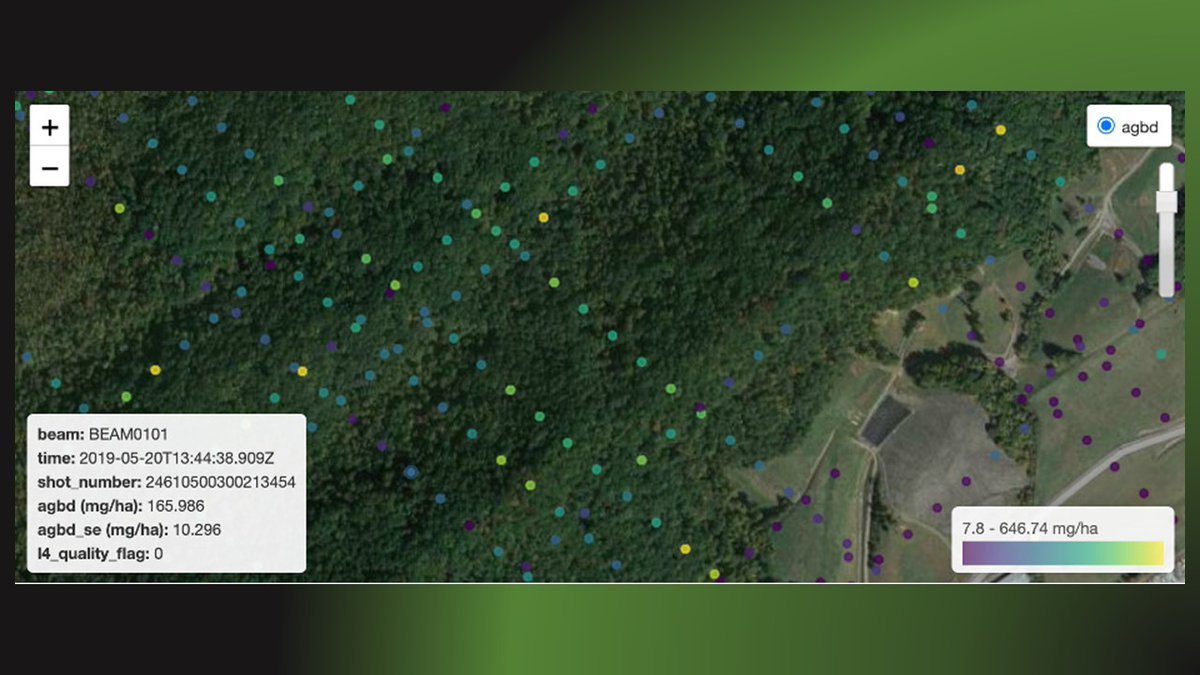
ALT This image shows a subset of Global Ecosystem Dynamics Investigation (GEDI) Level 4A footprint-level aboveground biomass density in a forested area near Oak Ridge, Tennessee
The most important activity at NASA's #GESDISC is archiving and distributing NASA Earth science data. GES DISC released 26 datasets to the scientific community in 2022. #EarthdataEnablesScience
Read the 'Top 10 Highlights': go.nasa.gov/3IlHnD0
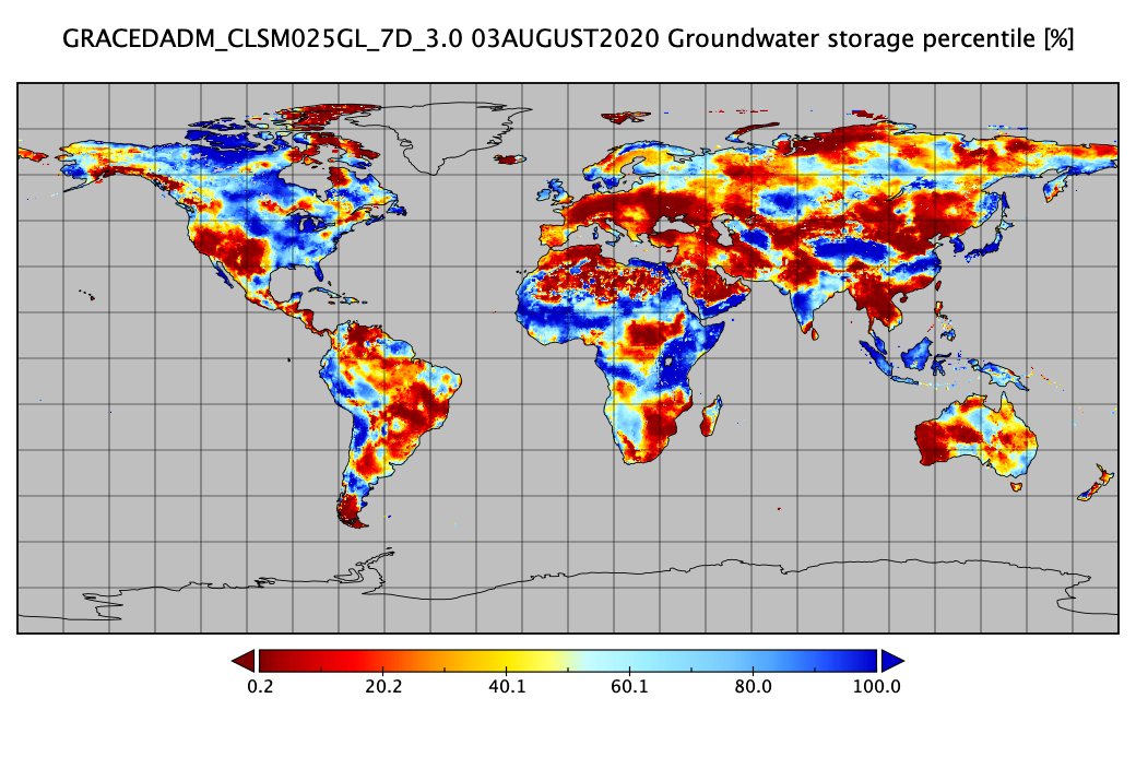
ALT One of the 26 datasets released by the NASA GES DISC in 2022 was the Gravity Recovery And Climate Experiment (GRACE) Data Assimilation for Drought Monitoring (GRACE-DA-DM) dataset. The image shows global values of one of the data variables in the dataset, Groundwater Storage Percentile, on August 3, 2020.
Studying dust storms and enabling science with NASA data are the subjects of #AGU22 presentations on Friday, Dec. 16 featuring contributions from many NASA #GESDISC personnel. See the schedule: go.nasa.gov/3BxEpaL#EarthdataEnablesScience
Learn how @NASAEarth observation near real-time data can be used to aid in the response to earthquakes, floods, and other natural hazards in our new Data User Profile for Dr. Maggi Glasscoe. Read about her work: go.nasa.gov/3CtHg2i@UAHuntsville#EarthdataEnablesScience
New from #NASASedac: Global Subnational Infant Mortality Rates (IMR) v 2.01 contains estimates of births infant deaths for 234 countries territories, to 2015. buff.ly/31XjRq2
What new NASA EOSDIS Earth science datasets were released last week? You’ll find new Soil Moisture Active Passive (SMAP) Validation Experiment (VEX) datasets at the NSIDC DAAC and more. Find out in the weekly data update: go.nasa.gov/33dd3WN, #EarthdataEnablesScience
ICYMI: The Earthdata webinar, "A Clearer View of the Haze – Using NASA GES DISC Data Tools to Examine the June 2020 Sahara Dust Event over Barbados" held on 9/23/20 is now available online. #EarthdataEnablesScienceyoutu.be/CwMOF4FzULE
NASA’s Earth Science Data and Information System (ESDIS) Project is preparing for cloud migration by providing analysis-ready data, modeling data egress, and providing resources for cloud computing. Learn about these efforts: go.nasa.gov/2RIVI1V#EarthdataEnablesScience
ICYMI: The "Data-Driven Storytelling: Using Atmospheric Data to Share Your Science" Earthdata webinar, held on 3/25/20 is now available for viewing online. #EarthdataEnablesScienceyoutu.be/LE4uXxs6yTY
ICYMI: There is still room in tomorrow's "Data-Driven Storytelling: Using Atmospheric Data to Share Your Science" Earthdata webinar. For information or to register: go.nasa.gov/2TROIkG, #EarthdataEnablesScience
ICYMI: The "History and Evolution of Satellite Remote Sensing Ocean Color Science" Earthdata webinar held on 2/26/20 is now available for viewing online. #EarthdataEnablesScience
View webinar: youtu.be/5-_wMG9l5iM