
1 May 2025
Want to explore real-world GIS app design trade-offs?
Check out the full article on Life in GIS:
lifeingis.com/why-building-g…
Let me know what trade-offs you’ve faced in your builds.
#GISdev #GeoAI #WebMapping
1
1
3
131

2 Feb 2025
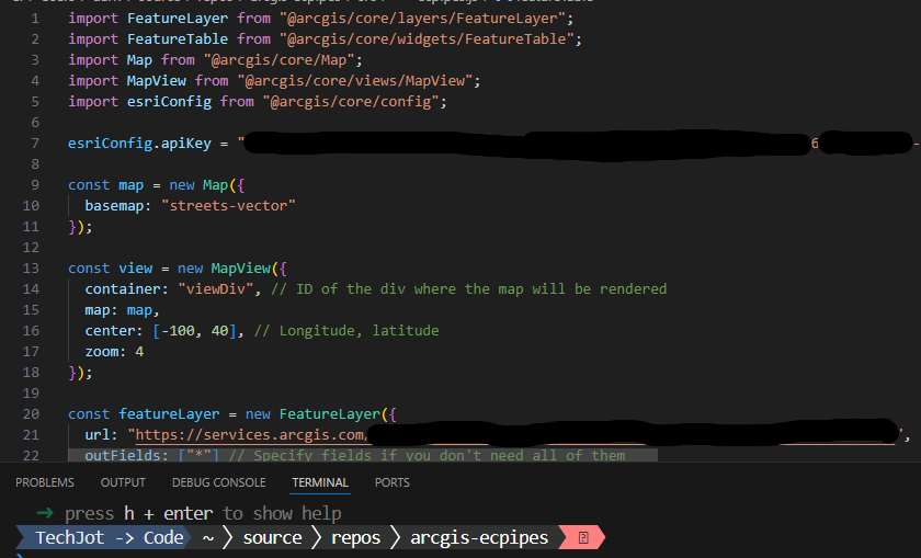
ArcGIS JavaScript SDK Developer!!!
How do you feel about the changes of the JavaScript SDK by ESRI?
1⃣AMD
2⃣arcgis/core
3⃣arcgis/map-components
1⃣Development was once primarily done using the Asynchronous Module Definition (AMD) pattern. This approach was straightforward when using Dojo, but it could feel somewhat clunky. Over the years, though, I've become quite adept at working with AMD.
2⃣Now, development has shifted to using ES modules, which introduces additional complexity, particularly for newcomers. I find ES modules align well with my programming style, and I'm very comfortable with ES modules. However, for smaller projects, they can feel bloated. Despite this, ES modules remain my preferred method for developing with the ArcGIS JavaScript SDK.
3⃣There's another approach, called @arcgis/map-components, which adds its own complexity but aims to simplify development. This package builds on @arcgis/core by offering pre-built UI components as web components. It cuts down on the boilerplate code for typical map-related tasks, providing ready-to-use elements like <arcgis-map> or <arcgis-legend>. These components work regardless of whether you're using a specific framework or just vanilla JavaScript, which I find pretty cool. It's meant to streamline the creation of GIS web applications, even though it does introduce some new layers of complexity to manage.
#GIS #GISDev
1
3
159
3 Jan 2025
Have you ever installed and managed any of the following software?
If you have, lets connect. Follow and I will follow you back.
#GIS #GISAdmin #GISTech #SystemAnalyst #GISDev

1
58
21 Jul 2024
1
1
6
361
19 Jul 2024
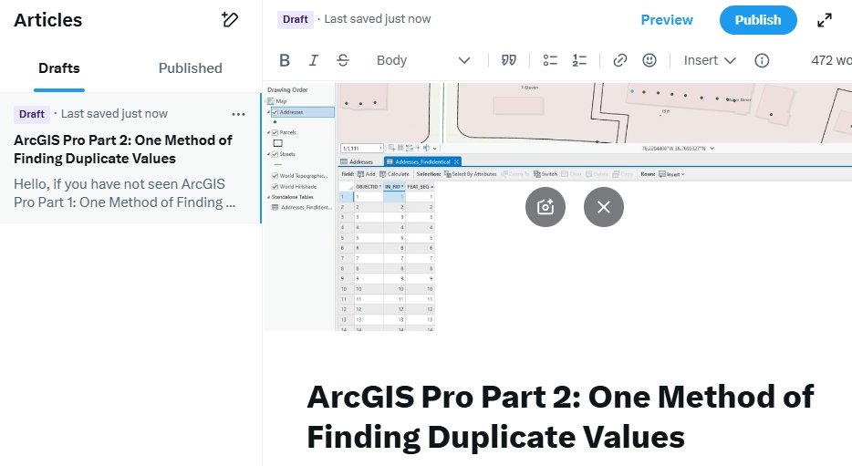
In Arcgis Pro, how do you find duplicate data in your attributes? For instance, let's say you have a field called WMSerial and you have 20,000 record(rows). How would you go about finding records that have duplicates in the WMSerial field?
#gis #gisdev #dataanalyst #analyst

1
1
188
9 Jul 2024
GIS Analyst: 3 Fundamental Maps you should know:
1⃣ Reference Maps: Provide general information about locations, featuring various natural and man-made features such as roads, rivers, and cities. They serve as a base layer for more specialized maps.
2⃣ Thematic Maps: Focus on specific themes or subjects like population density or climate. They are designed to visualize patterns, distributions, and relationships within the data.
3⃣ Topographic Maps: Display the physical features of the Earth's surface, including elevation contours, mountains, valleys, and other terrain features. They are essential for understanding geographical context and landscape analysis.
#gis #data #dataanalyst #analyst #Analytics #gisdev #map

4
11
373
9 Jul 2024
When it comes to government and GIS in the US, most governments don't need anything more than the following Open-Source GIS Software.
1⃣ Database: PostgreSQL
2⃣ Map Application: QGIS with GRASS
3⃣ Web Presence: GeoServer / OpenLayers / Linux / Apache Web Server
That is several thousand dollars a year that a government could be saving by using open-source software. If support is needed, it can be obtained.
If you have not tried QGIS Cloud, give it a spin:
qgiscloud.com
Happy GISing and Data Analyzing!!!
#gis #data #dataanlytics #dataanalyst #gisanalyst #gisdev #developer

3
3
13
827
30 Jun 2024
Want to learn how to make ArcGIS Pro Add-On(s)? Here is what you need to know first to get started:
1⃣ Some knowledge of programing and CSharp C#
2⃣ You will need Visual Studio 2022 Community
3⃣ Windows Operating System
4⃣ You will need ArcGIS Pro Personal or higher license, which a Personal License copy can be obtained for $100 USD a year.
Get Visual Studio 2022 Community form the following link:
Download Visual Studio Tools - Install Free for Windows, Mac, Linux
visualstudio.microsoft.com/d…
Get a copy of ArcGIS Pro Personal from the following link:
ArcGIS for Personal Use Pricing | Buy Now
esri.com/en-us/arcgis/produc…
Once you have everything, you need to open up Visual Studio 2022 and go to Manage Extension and install the ArcGIS Pro SDK for .NET. Once that is installed, you can start building.
Happy Coding and solving problems!!!
#gis #gisdev #developer #code #engineer #software #gisanalyst #analyst #ArcGISPro #ArcGIS #

2
4
467
29 Jun 2024
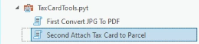
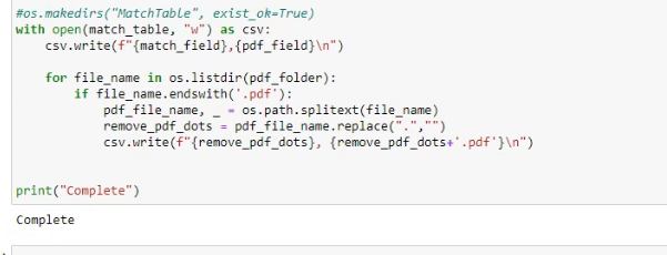
Custom Python tool I create for this one project. The tool is great but OMG they need to update the computer. It is a little slow when working with only 50,000 parcels and tax card pdfs but gets the job done lol
This client was paying thousands of dollars a year for an old, outdated GIS website and having the company tie their tax card data to the parcels. I come along and created this two step script that simply converts their JPG tax cards to pdf and then attaches each tax card to the 80,000 different parcels. This has to be done ever 6 months. Now their GIS person can easily achieve this.
Also, I built them a custom ArcGIS Online website using Experience builder with a custom popup that will show the tax card information online. Now to update the parcels with the tax card, all they have to do is run the script and right click and share/overwrite the parcel layer to ArcGIS Online
I made a nice little penny off this job too and it is a gift that keeps giving.
With that said, look for problems and solve them. That is the engineer way.
Happy coding!!!
#GIS #gisdev #dev #codelife #csharp #python #arcade #data #dataanlyst #assetmanagement
3
233
28 Jun 2024
Man, I have been busy here lately. Between work and side hustles, WOW... lol
Here lately I have been making side money by building ArcGIS Online Websites and building ArcGIS Pro Add-Ons utilizing C#.
I just made $1100 USD in a day by creating a buffer select by location Arcgis Pro Add-On. Customer hated having to go to Tools->Buffer-> and create the buffer then go to Select By Location and put in the two layers(Parcel Buffer and Parcels) and choosing the Relationship.
Now with the addon, they just select the parcel, click a button and enter the buffer feet and BAM all the parcels are selected. No need to clean up a Parcel_Buffer and a lot of steps eliminated.
There is gold in those GIS mountains, just got to keep digging.
#GIS #Developer #Dev #gisdev #code #

2
2
10
827
26 May 2024
GIS Blurb: Behind the Map
Behind every Map is a slew of technologies. This is true for the many diverse fields. For instance, let's go down the GIS rabbit hole.
In GIS, you will find:
1⃣ Desktop Applications: There are all types of desktop applications that GIS professionals might use. For instance, Survey 123, ArcGIS Pro, QGIS, GRASS, Excel, Google Sheets, Libre Office Calc, RStudio, Python Notebooks, Visual Studio Code, Visual Studio IDE, PostgreSQL Admin 3, MSSQL Studio, Blender, Adobe Products, Pix4D, Bentley ContextCapture, and ESRI Site Scan for ArcGIS just to name a few.
2⃣ Databases: In the GIS field, there are all types of databases. There are File databases, SQL Databases / Geo-Databases, Network Database and NoSQL Databases such as Graph Database just to name a few.
3⃣ Servers: Yep, there are all kinds of servers in GIS and this is especially true in large government institutions or private Entities. You will find GIS Servers such as ArcGIS Server, Geo-Server and QGIS Server. These servers are used for sharing data such as vector and raster data and for different types of geospatial processing such as geocoding. Not only GIS Servers and Tile Servers but entities such as ESRI, offers enterprise products and under their Portal offering, ESRI offer many other types of servers such as Portal for ArcGIS, ArcGIS Data Store and ArcGIS GeoEvent Server, which enables real-time event-based data streams to be integrated as data sources in your enterprise GIS setup. But wait, there is a lot more such as Web Servers (IIS, Apache, Nginx), DNS Server and more.
4⃣ Systems: Not only are there a lot of Desktop Applications and Server Software, but there are also physical systems that are behind the Map. For instance, take your Desktop at work. Depending on what you do in the Data / GIS arena, you might be running with a ASUS TUF RTX 4090 OC Graphics Card (PCIe 4.0, 24GB 384Bit GDRR6X, HDMI 2.1a, DP 1.4a, ARGB), w/SPS x Dino DP to HDMI Converter with a AMD Ryzen Threadripper 3970X 32-Core, 64-Thread Unlocked Desktop Processor or better. On top of that, you have to think about drives and volatile memory (DDR5 / RAM) that goes into these systems and lets not forget about the motherboard and power supply.
5⃣ Networks: That is right, networks. If it was not for networks, all those servers would not be possible. Networks are made up by many different devices such as modems, routers and switches. A lot goes into networking and creating different topologies and securing network infrastructures.
On that note, it's evident that there's a vast landscape Behind the Map. GIS encompasses a multitude of facets, offering diverse career opportunities for individuals to explore and specialize in various areas.
#gis #gisdata #IT #gisanalyst #analyst #informationtechnology #technologies #tech #dev #gisdev #python #QGIS #ArcGIS #GRASS #GeoServer #Networks #Servers #Database #MSSQL #PostgreSQL

1
4
13
740
16 May 2024
In my experience, GIS Tech equals:
1⃣ Database Administrator
2⃣ Developer
3⃣ Data Analyst (A book or two right here)
4⃣ Data Engineer
5⃣ Data Scientist
6⃣ Cartographer
7⃣ System Analyst
8⃣ Tech Support
#gis #gistech #technology #developer #code #analyst #tech #database #gisdev

4
3
14
685
5 May 2024
GIS Project: Operation Web Site Upgrade
Well, this project for a county is about complete.
This project mainly deals with Parcels and Land tax, but other layers are involved too.
Scenario: Client wanted to update their web site to use Arcgis Online. Since they were already paying for 3 Arcgis Pro licenses, the client wanted to move to ArcGIS Online. If you do not know, ArcGIS Pro comes with 500 credits of Arcgis Online and you can purchase 1000 credits for $120 dollars.
They wanted to move to ArcGIS Online because they were paying $10,000 for the other Web Service provider. To update the Website, they had to send the Tax card Images to the provider and then they turn them to pdf and linked them to a field a person could click on and download. Not only that, to update the layers, a person had to login to an FTP site and upload the exported parcel and other layer shape files to the server and then email the company so the parcels and tax cards could be linked and updated. Sometimes it could take 2-3 days before the update.
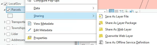
I know, WOW. Anyways, with this new workflow I have created and utilizing ArcGIS Pro and ArcGIS online, the client will save $9000 dollars a year and have more control over their data and the data will be updated as soon as their GIS person clicks Share As Web Layer or Overwrite Web Layer
The Work Flow:
Open ArcGIS Pro and then click on the tools in order as seen below and run each one:
After completing those tasks, Overwrite the Web Layer and done. Everything is updated and looking good on their new gorgeous ArcGIS Online website.
Skill Set level: Intermediate.
Skill Set:
1⃣ ArcGIS Pro
2⃣ ArcGIS Online
3⃣ Arcade Programming Language
4⃣ Python Programming Language
5⃣ SQL Database Knowledge
Work Done 1 Year Support = Estimate Net Profit
Estimate Net Profit: $6000.00 USD
On that note, keep learning and practicing!!! There is still gold in those tech hills💰💯😀
#arcgis #arcgispro #esri #anaylst #data #arcgisonline #gisdev #dataanalyst #Python #Arcade #QGIS #GRASS #Lidar #raster #vector


3
7
54
4,594
1 May 2024
Domain Knowledge Tech Skills = Pay Day.
I just earned $100.00 usd by prototyping the following code, which will be incorporated into a larger project.
This code will be incorporated into a Python Toolbox, which is being built to increase the efficiency of a workflow.
By knowing a domain and skillfully applying your technical expertise, you not only unlock solutions but also open the door to financial reward. Your domain knowledge and tech skills become the currency through which opportunities flow, turning your passion into profit.
On that note, keep practicing and learning!!!
#gis #gisdev #data #dataanalyst #gisanalyst #ArcGISPro #ESRI #QGIS #GRASS #Engineering #Engineer #IT #Business #Analyst
1
2
9
1,074

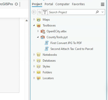
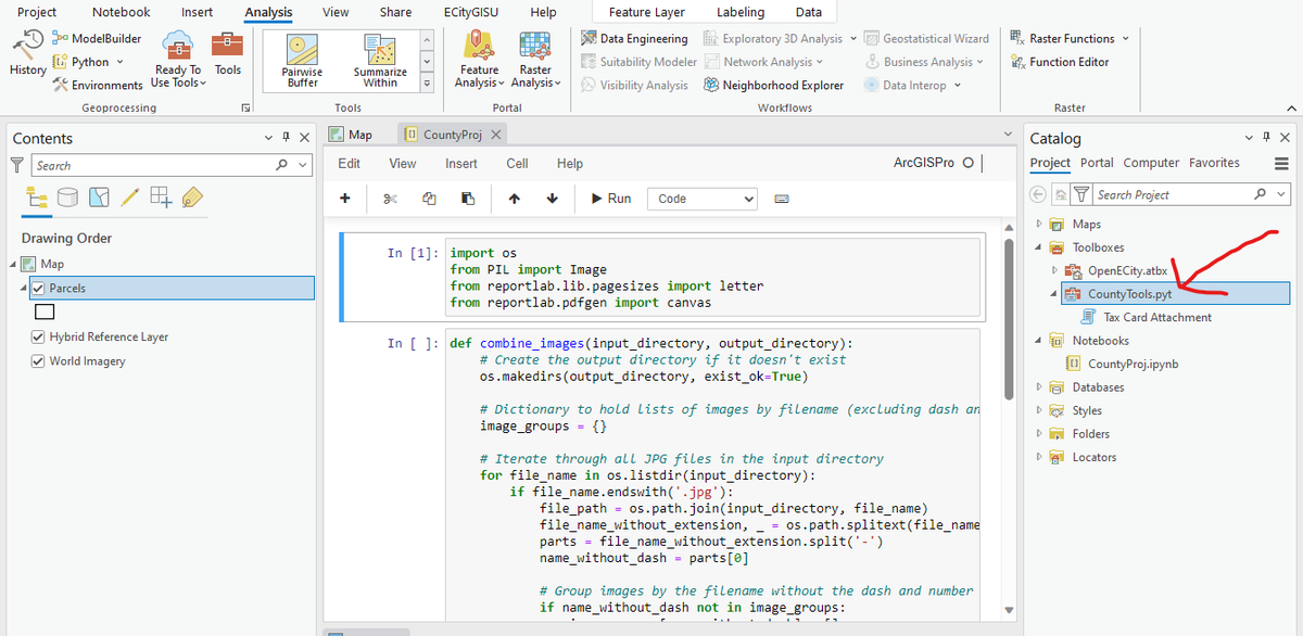
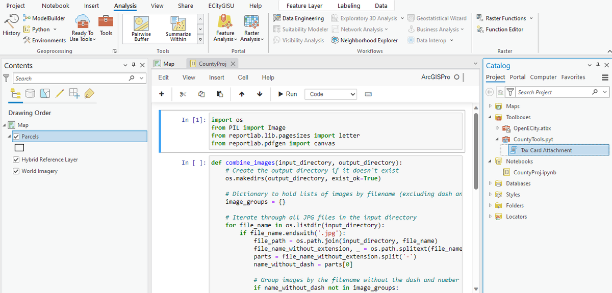
GIS / Data Analyst Tools: ArcGIS Pro Toolboxes.
#ArcGISPro #ESRI #Python #Tools #data #gis #gisdev #gisanalyst #analyst #dataanalyst
28 Apr 2024

GIS / Data Analyst Tools: ArcGIS Pro Toolboxes
In the government world (US) and in my experience, ArcGIS software is utilized a lot.
One thing I like about ArcGIS Pro is the built-in Python Notebooks and the ability to create Python Toolbox
Built-In Python Notebooks
Python Toolbox:
What I find nice about this setup is that I like to do the prototyping in the Notebooks and then transfer the code etc to an ArcGIS Pro Python Toolbox.
Toolbox:
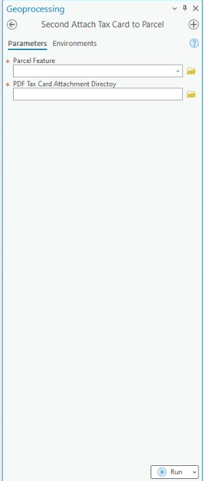
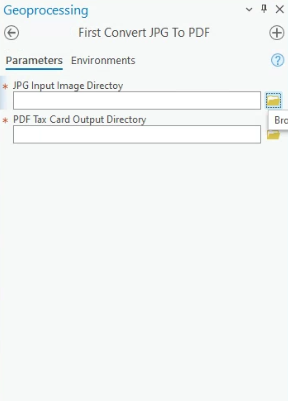
In the images above, I am actually working on a side hustle for a county. I am working on transforming their old GIS Website to an ArcGIS Online website, but their old website has thousands upon thousands of tax cards connected to their parcels and they would like these cards with their new website. Their tax cards are in jpg format, but they want the cards in pdf and the cards that belong to each other, they want combined into one pdf.
The place that used to manage their website used to do all this for them, which cost them a lot of money per year, but the county wants a nice workflow built so their GIS person can manage the new ArcGIS website and be able to convert the tax cards to pdf and attach them to the correct parcel twice a year.
This is where the Python Toolbox comes into play. The Toolbox you see in the image will do all that for them. Once the tool is run, all the GIS person will need to do is push their feature layer to ArcGIS Online with just a few clicks.
So, what are you waiting for? Start playing with Python and start building some tools.
On that note, keep practicing!!!
#ArcGISPro #ESRI #Python #Tools #data #gis #gisdev #gisanalyst #analyst #dataanalyst


73
28 Apr 2024
GIS Developer Tool : ArcGIS Maps SDK for JavaScript
There are a lot of awesome open-source JavaScript libs out there such as Openlayers but the proprietary ArcGIS Maps SDK for JavaScript is a top notch SDK I think people should look at and witness its capabilities.
For instance, if you are building an application for Line of Sight analytics, this SDK will have your back.
What's really awesome about it is how easy it is to implement into your web application.
Line of Sight analysis is used in many different areas. For instance, Line of Sight is used in Planning, Telecommunication, Environmental Studies, Safety and Security and Transportation just to name a few areas where you might find this type of analysis.
On that note GIS Developers, if you are not playing with ArcGIS Maps SDK for JavaScript, give it a try today.
Links below:
Line of Sight:
developers.arcgis.com/javasc…
Getting Started:
developers.arcgis.com/javasc…
#gis #dataanalyst #analyst #developer #javascript #gisdev #webdev #gisanalyst #code #python #ESRI #ArcGIS #ArcGISPro #QGIS #GRASS

4
14
823
28 Apr 2024
GIS / Data Analyst Tools: ArcGIS Pro Toolboxes
In the government world (US) and in my experience, ArcGIS software is utilized a lot.
One thing I like about ArcGIS Pro is the built-in Python Notebooks and the ability to create Python Toolbox
Built-In Python Notebooks
Python Toolbox:
What I find nice about this setup is that I like to do the prototyping in the Notebooks and then transfer the code etc to an ArcGIS Pro Python Toolbox.
Toolbox:
In the images above, I am actually working on a side hustle for a county. I am working on transforming their old GIS Website to an ArcGIS Online website, but their old website has thousands upon thousands of tax cards connected to their parcels and they would like these cards with their new website. Their tax cards are in jpg format, but they want the cards in pdf and the cards that belong to each other, they want combined into one pdf.
The place that used to manage their website used to do all this for them, which cost them a lot of money per year, but the county wants a nice workflow built so their GIS person can manage the new ArcGIS website and be able to convert the tax cards to pdf and attach them to the correct parcel twice a year.
This is where the Python Toolbox comes into play. The Toolbox you see in the image will do all that for them. Once the tool is run, all the GIS person will need to do is push their feature layer to ArcGIS Online with just a few clicks.
So, what are you waiting for? Start playing with Python and start building some tools.
On that note, keep practicing!!!
#ArcGISPro #ESRI #Python #Tools #data #gis #gisdev #gisanalyst #analyst #dataanalyst
4
22
115
9,600
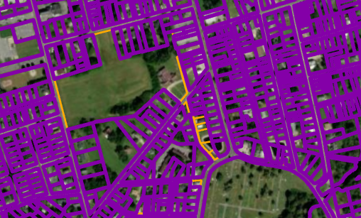
19 Apr 2024
Well, I am doing a few different things.
The image you see is from an ArcGIS addon I built that helps manage parcels for a city.
Scenario: The county does all the parcels and then sends them to the City / Cities once a year. A lot of times the city has to correct the parcels within their city. This means fixing overlaps/ slivers and other anomalies that makes you say WTH LOL. Not only does the City have to fix the parcel shape and double check the metes and bounds because there is always some intern messing something up LOL(Sorry for blaming all you intern out there LOL), but they also have to update all the new parcel attribute data.
Well, each year the City / Cities are getting parcels from the county with incorrect metes and bounds and different anomalies such as slivers and overlaps. This means, each city/town has to correct this each year after they have made updates to their parcels, and they have to incorporate the new attribute data. As you can see, going over 100,000 parcels or more could be quite challenging for a City/Town.
Well, what my addon does in the image is transfer all the attribute data from the county parcels to City / Town clean and correctly shaped parcels. This saves a lot of time. You pretty much just select the county parcels and then click a button and the addon does all the work. It shows if new parcels have been added/split, like you see in the image where there are orange lines. Those orange lines tell a person there is a problem in that area and my program could not resolve and someone needs to manually investigate. It could be new parcels, or a parcel has been split or really really really bad overlaps/ slivers or one of those thing that makes you say WTH LOL. With that said, I will have to make a video of the addon and post it one day.
On that note:
This weekend, I will be building a new ArcGIS Online site for another county and linking their parcels to their tax cards. I have also built them an addon that easily creates their parcel pin numbers and inserts it into their attribute data. They and other counties / cities / towns generate their parcel pin off a grid system or the centroid of the parcel, which I have talked about the grid system in the following post.
twitter.com/DatJot/status/17…
With that said, there is money to made in the GIS world. Find a problem and create a solution that saves time and money. Win Win.
Actually, that is how I got this side hustle. They were paying $10,000 a year for some outdated GIS website, and they asked me for consultation. During my analysis, I discovered they had 3 ArcGIS Pro licenses and ArcGIS Online they were already paying for. I told them they have ArcGIS Online already, and they could be shaving $9900 dollars a year if they would build their website utilizing ArcGIS Online. Also informed them of the improves too and how nicely ArcGIS Pro integrates with ArcGIS Online and all the wonderful things they could achieve... LOL had to slap that butter on there lol
With that said, learning about Government Assets, GIS, SQL Databases, Programming (Python/JavaScript/ HTML/ CSS), ArcGIS Addons (Programming with C#), All of Esri Enterprise like Portals / ArcGIS Server, a person will not go hungry.
Problem Solution = Pay Day.
#gis #gischat #ArcGISPro #ArcGIS #gisdev #developer #Engineer #Engineering

15 Oct 2023
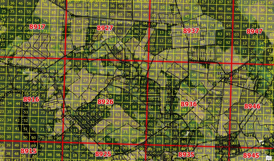
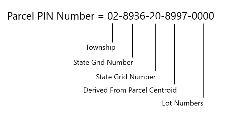
Generating Parcel PIN Numbers:
In the USA and as a person in the GIS field, I have seen a few different elaborate schemes for generating parcel PIN numbers. The majority of the different counties generally use a system similar to PLSS (Public Land Surveying System) but instead of using 6^2 miles like the PLSS, some States generally create their own grid system like in the image below and the county / cities utilizes this grid system for parcel PIN numbers.
The first two numbers of the PIN represent the township in the county. So, if the county has 4 townships, the township would be numbered like below:
Town 1: 01
Town 2: 02
Town 3: 03
Town 4: 04
Generally, there is a layer outlining the townships.
With that said, the first two numbers in the PIN could be 02, which represents Town 2.
Next for the next 4 numbers, they use the numbers in the grid scheme from the state. This would be the red squares in the image below.
If the Parcel is in 8936, our PIN is now 02-8936.
Next, we would move to the next grid, the yellow grid. Also, this grid has a numbering scheme. The GIS person would locate the parcel in the yellow grid and then use the number where the parcel is located.
For this example, we will say it is located in the yellow grid that has the number 20. If the parcel is located in two yellow grids then generally the GIS person eyeballs the centroid of the parcel and wherever the centroid of the parcel is located, that is the grid that is used.
Now the parcel PIN number would be 02-8936-20
To locate the next four numbers of the PIN, the GIS person finds the x and y centroid of the actual parcel and develops a scheme to extracts numbers from the x and y centroid to create the next 4 numbers.
So depending on the software the county is using, this can be done in a few ways. Using ESRI's ArcGIS Pro, a GIS Analyst could use Python or create an addon to get the x and y centroid of the parcel and then generate 4 numbers from the x and y centroid.
For example, let's say we have a x and y centroid like below:
x_cent = 8657896.59033
y_cent = 1202973.78254
The GIS Analyst would use Python or Arcade to generate the next 4 numbers for the PIN.
To generate the next four numbers, the script would extract the fifth number from the x and y centroid so you would have 89.
In order to get the other two numbers, the script would extract the sixth number from the x and y, so the next two numbers would be 97 and we would then have our next 4 numbers, which is below.
Next four numbers = 8997
Parcel PIN Number = 02-8936-20-8997
We are almost done now. There are 4 more numbers. Generally, the GIS Analyst would just tack on four 0 to the end of the Parcel PIN number. This is used in case they are working with something like a trailer park where there is one big parcel owned by an entity that has lots on the parcel. If there were 30 lots on the parcel, the last numbers would be 0030. If the parcel is not divided in lots, the numbers would be 0000.
On that note, and since this pretend parcel does not have lots, our whole Parcel PIN number is below:
Note, here we have 16 digits. In some places they have 18. This is because instead of using two grids they have 3 grids to represent certain areas.
On that note, I hope you find this information useful and informative. There are other ways to generate parcel PIN numbers but in most of the states and counties I know of uses some form of grid system to generate the PIN numbers and they use a method similar to the method described here.
In your geographic location, how do they generate Parcel PIN numbers?
Happy analyzing!!!
#gis #planning #planner #plan #gischat #analyst #land #parcel #property #grid #gridsystem #gisanalyst #gisdev #state #county #country #providence #city #realestate

3
1
2
175
19 Apr 2024
What are you working on today? I have been working on thousands thousands thousands thousands thousands of Parcels LOL. I think I am Parceled out LOL
BUT THERE IS MORE.
For one of my side hustles, guess what I have to work on this weekend.... Yup Parcels LOL.
Learn about Government assets, GIS, SQL Databases, ArcGIS Online, ArcGIS Pro, ArcGIS Pro Addons, Python and you will not go hungry.
Anyways, just had to take a quick eye break LOL back to the grid🤣☕️💯
#gischat #gis #dev #gisdev #code #developer #ArcGISPro #ArcGIS #QGIS #sql
3
8
560