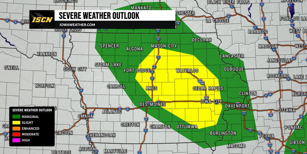
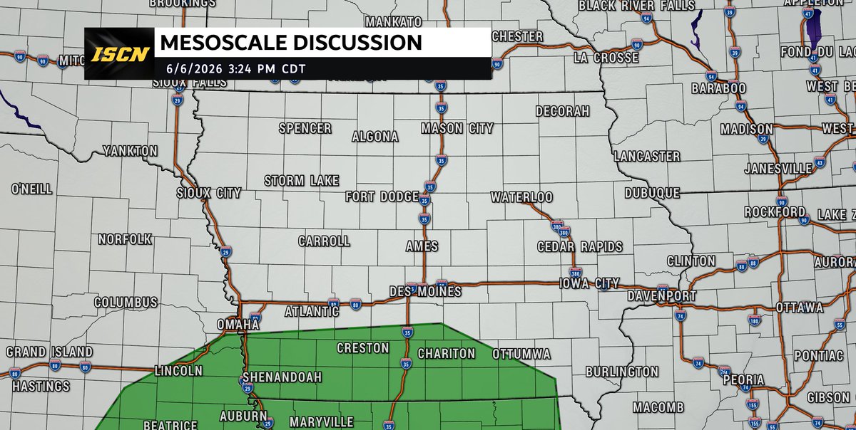
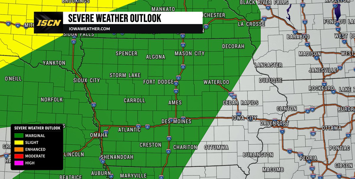
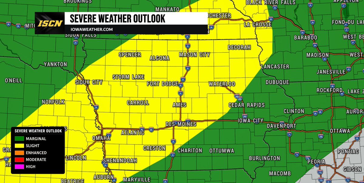
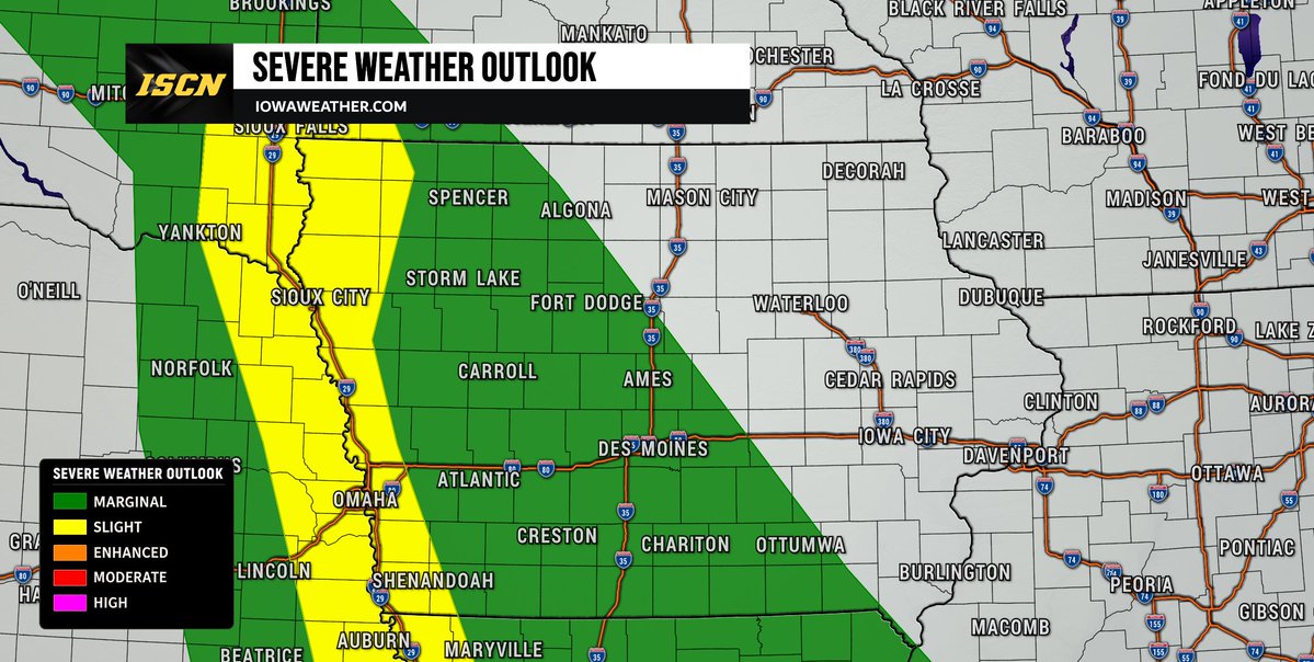
We're continuing to monitor the potential for severe weather across eastern Iowa on Wednesday, where portions of eastern Iowa have been placed under and slight to enhanced risk of severe weather.
The day may begin with scattered showers and thunderstorms moving through parts of central and eastern Iowa during the morning hours. How these morning storms evolve will play a major role in determining what happens later in the day. If the atmosphere is able to recover after the morning activity moves out, additional thunderstorms could develop along an approaching cold front during the afternoon and early evening.
The primary severe weather threats across Iowa appear to be damaging wind gusts and large hail. While an tornado threat cannot be completely ruled out, the greatest tornado threat currently appears to be southeast of Iowa, closer to parts of Illinois and Indiana.
There is still some uncertainty in the forecast. If morning storms linger into the afternoon or if the cold front moves through earlier than expected, the severe weather threat would be push outside the state of Iowa. However, if enough sunshine develops and the atmosphere becomes unstable during the afternoon, stronger storms would become more likely across eastern Iowa.
Make sure you have the ISCN Weather app installed and check back as we continue to monitor conditions and provide the latest updates.
#iawx #iowaweather #severeweather #weatherupdate

2
14
1,374
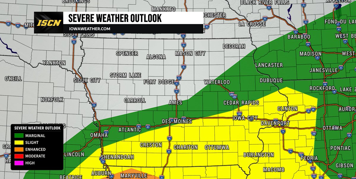
The Storm Prediction Center has upgraded portions of central and eastern Iowa to a Slight Risk (Level 2 of 5) for severe thunderstorms late tonight into early Wednesday morning.
Unlike many severe weather events that occur during the afternoon or evening, this threat is expected to develop after midnight and continue through the pre-dawn and sunrise hours on Wednesday.
The greatest concern at this time is large hail, with some storms capable of producing severe hail if they develop as expected. The strongest storm potential appears to be across parts of central and eastern Iowa. We will continue to monitor the latest data and provide updates throughout the evening.
If you want to be notified when a storm capable of producing hail is approaching your location, make sure you have the ISCN Weather app installed. The app can send hail alerts directly to your phone based on your location, helping wake you up and keep you informed if severe weather develops while you're sleeping.
Check back throughout the evening for the latest forecast updates.
#iawx #iowaweather #severeweather #hail
1
1
23
3,610

Our Weekly Academic Papers of the Week with our Research Review has just been posted in the #ISCN Community!
Click here to get a glimpse on what members receive each week - bit.ly/43cWGag

135

Jun 13
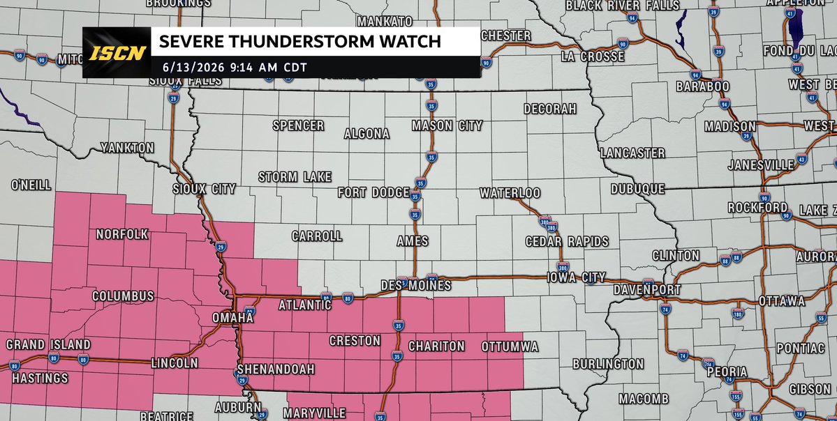
A Severe Thunderstorm Watch is in effect until 3 PM for portions of south-central Iowa.
A line of strong to severe thunderstorms moving through the region this morning is expected to continue east-southeast through the afternoon, bringing the potential for damaging wind gusts up to 70 mph and hail up to 1.5 inches in diameter.
The primary threat will be damaging straight-line winds, though isolated large hail is also possible. Stay weather aware, have multiple ways to receive warnings, and keep the ISCN Weather app handy for the latest updates. #IAwx
3
15
1,591


Jun 12
The Storm Prediction Center has placed much of southern Iowa under a Slight Risk (Level 2 of 5) for severe weather on Saturday afternoon and evening. While not everyone will see severe storms, some thunderstorms could become strong enough to produce damaging weather.
A cold front will move across Iowa throughout the day Saturday and will provide the focus for thunderstorm development. Forecast confidence is increasing that storms will develop during the mid-afternoon (after 2-3PM) and continue into the early evening (before 10PM), especially across southern portions of the state. However, there is still some uncertainty regarding exactly where the strongest storms will form and how widespread they become. The main threats with any severe storms will be large hail and damaging wind gusts.
We will continue to monitor the latest forecast trends and provide updates as confidence increases. Be sure to have the ISCN Weather app installed and check back throughout the day Saturday for the latest forecast updates and any watches or warnings that may be issued.
#iawx #iowaweather #severeweather
1
1
20
1,774
Jun 10
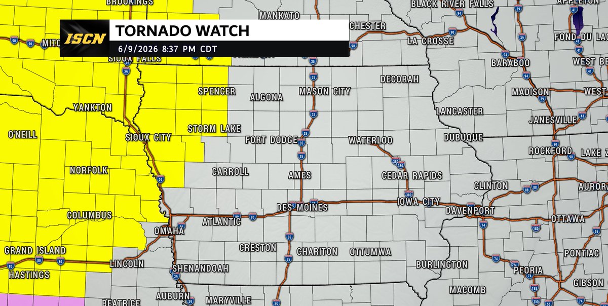
A Tornado Watch has been issued for northwest Iowa until 3:00 AM Wednesday as severe thunderstorms move into the area tonight.
Storms will be capable of producing large hail up to 2 inches in diameter, damaging wind gusts up to 75 mph, and a few tornadoes, including the potential for a strong tornado.
If you are in the watch area, make sure you have multiple ways to receive warnings overnight and keep the ISCN Weather app handy for the latest updates.
2
14
2,198

CALL FOR PAPER - SDGs Center Conference 2026
Salam SDGs! Bappenas bersama Indonesia SDGs Center Network (ISCN) mengundang Bapak/Ibu dari seluruh SDGs Center di Indonesia untuk berpartisipasi dalam SDGs Center Conference 2026 melalui pengiriman artikel/paper.

1
1
54
Thunderstorms are developing across portions of southern Iowa this afternoon and will have the potential to produce very heavy rainfall through the evening hours.
The greatest concern will be localized flash flooding, especially in areas that have received significant rainfall over the past couple of days. With saturated soils already in place, it won't take much additional rain to cause water to quickly collect in low-lying and flood-prone areas.
Some of the stronger thunderstorms may produce rainfall rates of 1 to 2 inches per hour, which could lead to rapid rises on small streams, flooding of roads, and water covering low spots. Storms are expected to move slowly, increasing the risk for heavy rain over the same locations.
If you encounter a flooded roadway, remember: Turn Around, Don't Drown. Never attempt to drive through water-covered roads.
Have the ISCN Weather app installed and check back throughout the afternoon and evening for the latest updates and any flash flood warnings that may be issued.
15
1,898
Take a look at this timelapse ISCN Storm Chaser Brennan Jontz captured of the storms developing south of the Des Moines metro Friday evening.
5
6
55
4,149
Strong to severe thunderstorms are possible across parts of Iowa later this afternoon and tonight.
The greatest risk appears to be across western, central, and southern Iowa, where a few storms could become severe as they move through the state.
Main threats include: large hail, damaging wind gusts, and isolated tornado, and heavy rainfall with localized flash flooding.
While not everyone will see severe weather, any storm that develops this afternoon and evening will need to be monitored closely.
We'll be tracking conditions throughout the day and will provide updates as new information becomes available.
Make sure you have the ISCN Weather app installed and notifications enabled so you can receive watches and warnings as they're issued.
#iawx #iowaweather #severeweather
12
1,310
A Flood Watch is in effect this afternoon through Friday morning for much of southwest and central Iowa, including the Des Moines metro.
Repeated rounds of thunderstorms may produce 2-4" of rain, with isolated higher amounts possible. Flash flooding could develop, especially in low-lying and flood-prone areas.
Never drive through flooded roads. Turn Around, Don't Drown.
📱 Stay weather aware with the ISCN Weather app and follow us for updates throughout the day.
#iawx #iowaweather #flood

1
17
1,577
Confidence is increasing that some thunderstorms could become severe Friday afternoon and evening across parts of Iowa.
The SPC has expanded the Slight Risk area slightly farther east. Large hail and damaging winds remain the primary threats, but a few tornadoes may also be possible if storms remain isolated Friday evening.
Morning storms and cloud cover will play a key role in how the threat evolves. We'll continue to refine the forecast over the next 24-36 hours.
📱 Stay weather-aware with the ISCN Weather app and check back for updates. #IAwx
1
26
2,137
A Severe Thunderstorm Watch is in effect for northwest Iowa until 1:00 AM CDT. Thunderstorms developing this evening may produce large hail up to 1.5 inches in diameter, damaging wind gusts up to 70 mph, and an isolated tornado or two. The tornado threat appears greatest with any storms that develop near a boundary across the region during the evening hours.
A separate Severe Thunderstorm Watch is in effect for portions of west-central and southwest Iowa until 3:00 AM CDT. Additional thunderstorms may develop later this evening and continue overnight, with large hail being the primary threat. Some storms could produce hail up to 2 inches in diameter along with damaging wind gusts up to 70 mph.
If you are located within either watch area, be sure you have multiple ways to receive warnings overnight, including the ISCN Weather app. We'll continue to monitor conditions and provide updates as needed.
#iawx #iowaweather #iowa #severeweather
1
2
9
1,662
The Storm Prediction Center has added a Slight Risk (Level 2 of 5) for severe weather this evening to include areas right along the Iowa/Nebraska border.
A few thunderstorms may develop near the Missouri River during the evening hours as a weak disturbance moves through the region. If storms are able to form, they could quickly become severe with the potential for damaging wind gusts, large hail, and an isolated tornado cannot be ruled out.
Storms are also developing farther north near southeastern South Dakota and may continue to pose a risk for large hail, damaging winds, and a brief tornado as they move southeast.
While widespread severe weather is not expected across Iowa tonight, residents in western Iowa—especially near the Nebraska border—should remain weather aware through the evening and overnight hours.
Be sure to have the ISCN Weather app installed and keep an eye on updates as we continue to monitor storm development.
#iawx #sdwx #newx #severeweather #weatherupdate
1
6
1,716
May 29
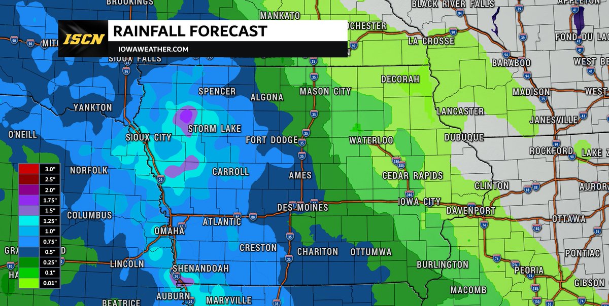
Rain chances will continue across Iowa through the weekend, with the highest rainfall totals expected across the western half of the state.
Scattered showers and thunderstorms will be possible overnight tonight, with additional rounds of rain expected on Saturday and Sunday before conditions gradually dry out by Monday morning.
According to the latest rainfall forecast from the Weather Prediction Center, areas west of Interstate 35 can expect widespread rainfall totals of 0.5" to 1", with some locations in western Iowa potentially exceeding 1". Farther east, rainfall amounts will generally be lighter, with most areas seeing between 0.1" and 0.25".
If you have outdoor plans this weekend, be prepared for occasional periods of rain and keep an eye on the forecast for updates.
Download the ISCN Weather app and check back throughout the weekend for the latest forecast updates and radar trends.
#iawx #iowaweather #rainfall #iowa
2
15
2,630

May 23
A marginal risk of severe weather will be possible across northwest Iowa late Sunday (May 24th) into early Monday morning as thunderstorms move through the region.
The main threats will be large hail, with some hailstones possibly reaching up to 2" in diameter, along with damaging wind gusts.
While not everyone will see severe weather, this is Memorial Day weekend and many people will be outdoors camping, boating, or attending cookouts. Now is a great time to make sure you have the ISCN Weather app installed and stay tuned for updates throughout the day.
#iawx #iowaweather #severeweather
1
5
1,438

2
569

UCT recently hosted the biennial International Sustainable Campus Network (ISCN) Conference. This year, the conference brought roughly 90 delegates from around the world to Cape Town for a week of workshops, keynote addresses and conversations about what it means to make a university sustainable in 2026.
Read more: qr.codes/lU0I9X

1
425