
Jun 8
The Sibutu–Basilan Ridge as a Southern Philippine Tectonic Knot
The Sibutu–Basilan Ridge sits in one of the most complex tectonic junctions in maritime Southeast Asia. It lies between the Sulu Sea to the northwest and the Celebes/Sulawesi Sea to the southeast, near the transition between the Sunda Plate margin, the Philippine Mobile Belt, the Sulu volcanic arc system, and the broader Philippine–Molucca collision zone. The region is not governed by a single clean plate boundary; it is a compressed, segmented arc-basin system shaped by subduction, collision, strike-slip transfer, crustal rotation, and local extension.
The result is a high-strain zone where destructive earthquakes can come from three different source types: megathrust rupture along offshore trenches, shallow crustal faulting within the island arc, and submarine slope failure triggered by shaking.
1. The Megathrust Threat: Opposing Trench Systems
The largest regional earthquake and tsunami hazards come from offshore subduction systems. Around the southern Philippines, the trench geometry is complicated, but the key point is that oceanic basins on both sides of the Sulu–Mindanao corridor are being consumed or deformed along active convergent margins. PHIVOLCS maps the Philippines as surrounded by multiple active trenches, including the Sulu, Negros, Cotabato, and Philippine trench systems.
The Cotabato Trench
The Cotabato Trench lies off southwestern Mindanao, along the Celebes Sea side of the system. It is one of the most dangerous earthquake sources in the southern Philippines because it is close to populated coastlines, capable of large offshore thrust events, and historically associated with damaging tsunamis.
The 1918 Celebes Sea earthquake is commonly listed at about Mw 8.3, with severe shaking, a tsunami reaching about 7 meters in some places, and major damage along the Celebes Sea coast. NOAA’s historical earthquake database records major damage and tsunami heights of roughly 7 meters for that event. The 1976 Moro Gulf earthquake, generally described around M 7.9–8.0, produced one of the deadliest Philippine tsunami disasters, with thousands killed or missing in coastal Mindanao communities.
A useful correction: it is safer to say the Cotabato Trench is capable of large locked or partially locked megathrust behavior, rather than claiming it is uniformly “highly locked” everywhere. Locking varies by segment and is not always directly observable without dense geodetic data.
The Sulu–Negros Trench System
Northwest of the Sulu Archipelago, the Sulu and Negros trench system marks another major convergent margin along the Sulu Sea side of the Philippine Mobile Belt. Recent geologic work describes the Negros–Sulu trench system as a zone of frontal wedge deformation, accretion, and submarine landslide potential, which matters because tsunamis in this region may be produced not only by vertical seafloor displacement during megathrust rupture but also by earthquake-triggered slope failure.
This makes the Sulu Sea side especially dangerous for nearby islands: even a smaller offshore rupture, if shallow and close to steep submarine slopes, could generate a fast-arriving local tsunami with little warning time.
2. The Intra-Arc Fault Problem
The Sibutu–Basilan Ridge itself should be understood as a fractured island-arc corridor rather than a rigid block. The Sulu Archipelago is a chain of volcanic and coral islands extending from Basilan toward Tawi-Tawi and Sabah, forming a narrow structural bridge between Mindanao and northeastern Borneo.
Because convergence is oblique, not purely head-on, the region cannot absorb stress only through subduction. Some deformation is transferred into shallow crustal faults, strike-slip structures, normal faults, and rotating microblocks within the arc. These faults may not produce the largest regional earthquakes, but they can be devastating locally because they rupture at shallow depths beneath fragile island settlements.
A shallow M 6.5–7.2 crustal earthquake under Basilan, Jolo, Siasi, or Tawi-Tawi could cause severe ground failure, landslides, liquefaction in coastal fill, damage to ports and bridges, and localized submarine landslides along steep island slopes.
3. Stress Transfer Toward Mindanao
The southern Mindanao margin acts as a transition zone between offshore trench deformation and onshore faulting. The 2002 Mindanao earthquake, recorded by USGS as M 7.5, occurred south of Mindanao from shallow oblique-reverse faulting within the Sunda Plate. That event illustrates the mixed character of the region: deformation is not purely strike-slip or purely thrust, but often oblique, reflecting the complex way plate motion is partitioned around Mindanao and the Celebes Sea.
Simplified Structural Model
[ SULU SEA BASIN ]
│
▼
=== SULU–NEGROS TRENCH ===
│
[ BORNEO / SABAH ] ──► [ SIBUTU–BASILAN RIDGE ] ◄── [ MINDANAO / PMB ]
│ fractured arc blocks
│ strike-slip normal faults
=== COTABATO TRENCH ===
▲
│
[ CELEBES / SULAWESI SEA ]
Bottom Line
The Sibutu–Basilan Ridge is dangerous because it sits between two offshore seismic engines while also being internally broken by shallow arc faults. The worst-case hazard is not one single fault breaking in isolation, but a compound event: a large offshore thrust earthquake, intense shaking across weak island infrastructure, submarine landslides on steep basin margins, and a near-field tsunami reaching exposed coastlines within minutes.
A technically stronger framing is therefore:
The Sibutu–Basilan Ridge is a compressed and fragmented arc-basin corridor caught between the Sulu Sea and Celebes Sea tectonic systems. Its hazard profile combines megathrust earthquakes from the Cotabato and Sulu–Negros trench systems with shallow intra-arc faulting and submarine landslide risk. This makes the region one of the most complex and locally dangerous seismic zones in the southern Philippines.
1
1,784

If you look closely, you'll realize that this whole BIP110 operation is a maneuver to create extra money that will be converted. It's so simple to understand. The microblocks are just a pretext. When the wise man points at the moon, the fool looks at the finger.

1
4
31

May 26
4
63
May 24
1
69

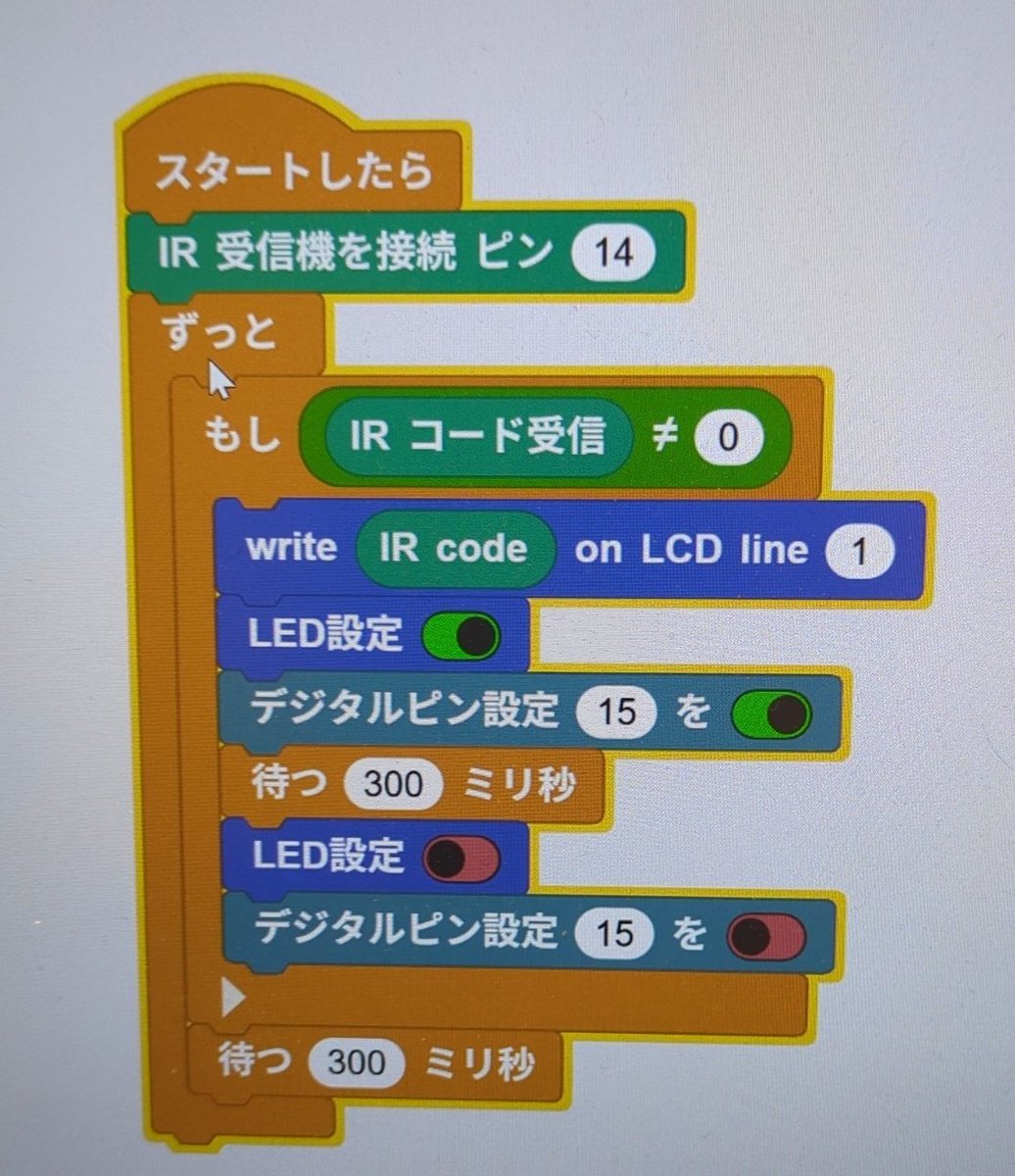
赤外線リモコンライブラリも1602LCDライブラリもあるし、操作も簡単!!
MicroBlocksかなりいい・・・今日CoderDojoでは娘とこれするゾ。
noteにもまとめたい。

1
7
128
MicroBlocks、娘大好き赤外線リモコンのライブラリもある模様!
ディズニーランドのポップコーンバケットをリモコンのボタンで好きな色の明かりが点くオリジナルライトに魔改造出来そうだ!!
色LEDたくさん内蔵じゃなくて、アナログピンとRGB LED使うのにチャレンジかな??
1
2
179
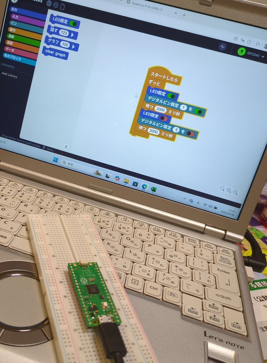
Coolest Project Japan2026の参加賞でもらったラズパイpico、ビジュアルプログラミングできないの??を調べてるんだけど(娘がもらったんだから娘に使わせたい人)MicroBlocksいい感じ!!
1
8
236

Apr 10
Slow chains are out. Smooth and simple is in
Why struggle with high gas and lagging deployments when you can launch faster on Aeternity?
aeternity.com/
⚡️ Lightning-fast microblocks 🛠️ Developer-friendly smart contracts 💸 zero fees
Scale without limits today.#Aeternity
22
2
26
433
Apr 10
🚨 Sick of high gas fees and slow networks? AEBIRD has entered the chat! 🦅
Watch as we break down why Aeternity is the ultimate blockchain evolution ⚡️ ~3-Second Microblocks 💸 Practically ZERO Gas Fees 🔒 Smarter, Safer Contracts
Stop waiting
aeternity.com/
#aeternity
10
2
15
253

Apr 9
⚡️Streaming
Your validator is now bound to a single builder that streams sequenced microblocks continuously throughout each slot.
Lower inclusion latency. Continuous shred propagation. The rest of the network sees your slot as it happens, not after it ends.
docs.harmonic.gg/concepts/st…
1
1
5
711

Apr 9
EVERYONE SAVE THIS !!!!
MASSIVELY IMPORTANT
This is how they're planning on connecting the communication system within the Intra-body electronics to the software created applications and the virtual machines that emulate physical hardware !!!!
1ST: THE GO-DOT ENGINE
Godot Engine – Multi-platform 2D and 3D game engine
github.com/robotics-intellig…
Remember Quantum Dots?
This is how they sync your energy with the Big 3
Physical
Digital
Quantum
This is the same company that created a very special type of wireless router that uses software that communicates with the Go-Lang.
OpenWrt One
This is the first wireless Internet router designed and built with your software freedom and right to repair in mind.
sfconservancy.org/activities…
LOOK AT THEIR PROJECTS
sfconservancy.org/projects/c…
ALL PROJECTS CONNECT TO THE UPCOMING BEAST SYSTEM
Literally all of these projects
1) Mercurial (Purgatorio / Inferno)
Mercurial is a fast, lightweight Source Control Management system which can track revisions to software during development.
mercurial-scm.org/
2) Metalink (Metaverse)
Metalink is dedicated to improving downloads. Metalink makes it much easier for people — especially those in areas with inferior Internet connections
metalinker.org/
3) MicroBlocks (MicroBits)
MicroBlocks is a new programming language that runs right inside microcontroller boards such as the micro:bit, the NodeMCU and many Arduino boards.
microblocks.fun/
4) OpenWrt
The OpenWrt Project is a Linux-based operating system targeting embedded devices. Instead of trying to create a single, static firmware, OpenWrt provides a fully writable filesystem with package management.
openwrt.org/
5) QEMU - (Inferno & Dis)
QEMU is a generic and open source machine emulator and virtualizer.
When used as a machine emulator, QEMU can run OSes and programs made for one machine (e.g. an ARM board) on a different machine (e.g. your own PC).
qemu.org/
6) Selenium
Selenium is a suite of tools for browser automation. It is composed of “IDE”, a recording and playback mechanism, “WebDriver” and “RC” which provide APIs for browser automation in a wide variety of languages, and “Grid”, which allows many tests using the APIs to be run in parallel
seleniumhq.org/
This is how they connect your energy to the Infernal Grid !!!!
sfconservancy.org/projects/c…
3
15
20
1,393
Apr 9
Check this out.
MASSIVELY IMPORTANT
This is how they're planning on connecting the communication system within the Intra-body electronics to the software created applications and the virtual machines that emulate physical hardware !!!!
1ST: THE GO-DOT ENGINE !!!!!
Godot Engine – Multi-platform 2D and 3D game engine
github.com/robotics-intellig…
Remember Quantum Dots?
This is how they sync your energy with the Big 3
Physical
Digital
Quantum
This is the same company that created a very special type of wireless router that uses software that communicates with the Go-Lang.
OpenWrt One
This is the first wireless Internet router designed and built with your software freedom and right to repair in mind.
sfconservancy.org/activities…
LOOK AT THEIR PROJECTS
sfconservancy.org/projects/c…
ALL PROJECTS CONNECT TO THE UPCOMING BEAST SYSTEM
Literally all of these projects
1) Mercurial (Purgatorio / Inferno)
Mercurial is a fast, lightweight Source Control Management system which can track revisions to software during development.
mercurial-scm.org/
2) Metalink (Metaverse)
Metalink is dedicated to improving downloads. Metalink makes it much easier for people — especially those in areas with inferior Internet connections
metalinker.org/
3) MicroBlocks (MicroBits)
MicroBlocks is a new programming language that runs right inside microcontroller boards such as the micro:bit, the NodeMCU and many Arduino boards.
microblocks.fun/
4) OpenWrt
The OpenWrt Project is a Linux-based operating system targeting embedded devices. Instead of trying to create a single, static firmware, OpenWrt provides a fully writable filesystem with package management.
openwrt.org/
5) QEMU - (Inferno & Dis)
QEMU is a generic and open source machine emulator and virtualizer.
When used as a machine emulator, QEMU can run OSes and programs made for one machine (e.g. an ARM board) on a different machine (e.g. your own PC).
qemu.org/
6) Selenium
Selenium is a suite of tools for browser automation. It is composed of “IDE”, a recording and playback mechanism, “WebDriver” and “RC” which provide APIs for browser automation in a wide variety of languages, and “Grid”, which allows many tests using the APIs to be run in parallel
seleniumhq.org/
This is how they connect your energy to the Infernal Grid !!!!
sfconservancy.org/projects/c…
2
16
24
1,100

Apr 6
#microblocks
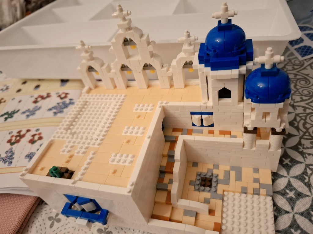
新しいミクロブロックを始めました😆サントリーニ島を模したものです。
OWの「イリオス」の舞台でもあって、ここ毎回負けるからあんまり好きじゃないんだけど、色合いが好き😊
完成品は2倍の大きさがあるので楽しみ✨️
22
249

Mar 28
Magic? How do they know exactly where they are? 🤯 Try using Snap! @SnapCloud to control multiple CoCube Robots!
#CoCube #STEM #maker #DIY #MicroBlocks
6
9
600

Mar 26
i'm making all items be buildable in game through microblocks and making it a scale invariant space game instead hope that's ok

1
5
45

Mar 20
Using a tiny printer to print a picture of CoCube Robot 🤣
CoCube is a desktop modular robot for education and research. See more at cocuberobot.com/products/
#STEM #education #MicroBlocks #CoCube #DIY
1
4
6
658
Mar 14
Motion control meets robot soccer! ⚽️🖐️
Nothing beats the feeling of controlling this CoCube bot with just a tilt of my hand. The precision is insane! 🤖🔥
#maker #hardware #coding #AI #CoCube #MicroBlocks #MicroPython #DIY
4
6
302
Mar 10
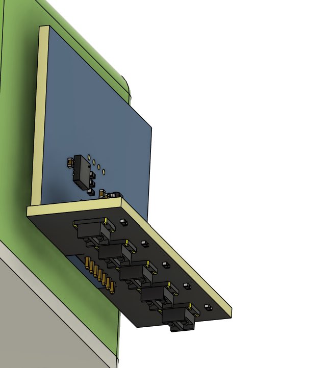
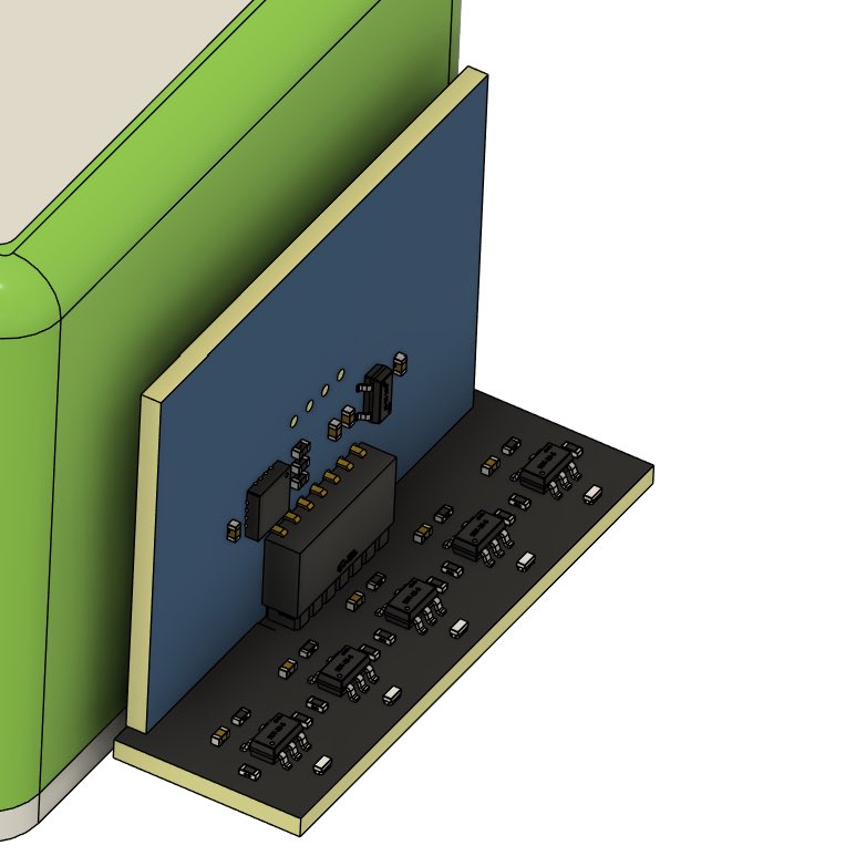
Redesigning the line tracking module for the CoCube Robot🤯
#CoCube #MicroBlocks #micropython #AI #PCB #EDA #maker
3
4
189