
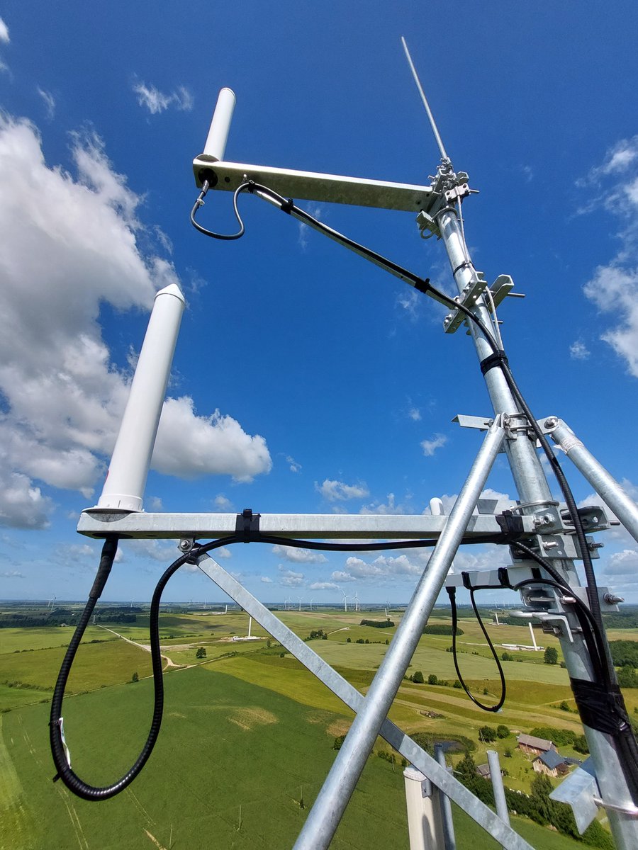
Era has installed its Wide Area Multilateration system (WAM) in Lithuania for air navigation service provider ORO NAVIGACIJA.
#WAM #ATC #ATM #airspace #compliance #EUROCAE #ANSP #cybersecurity
2
103
The difference between 03:08 and "just before" 04:00 is almost an hour, that's pretty significant, and not what the MoD spokesperson conveyed to the press, and the press conveyed to the public. Some even said the crash happened around 3:45, which is also incorrect. If the MoD spokesperson had told the press the accident happened around 3:00, 3:15, shortly after 03:00, something along those lines, I wouldn't have written anything.
I explicitly stated at LL it wasn't unusual to lose multilateration of their Mode-S transponder, I'm glad you agree.
I also explicitly stated the lead wouldn't know what happened behind them, and that's not weird, so I'm glad you agree there too.
1
210

May 30
What the past polls confirm is that the natl environment has stayed with 2025 (literally every single one)
theory of simply using 2025 data particularly Go, Aquino, Dela Rosa, Pangilinan and Tulfo by multilateration can come up with something very useful 👀
1
8
1,085

May 24
Makes sense. Listen for the radar signal and use multilateration to geo-locate the aircraft. Put it on every cell phone tower and it would have a range of 400km for aircraft at 40,000 feet; line of sight.
May 24

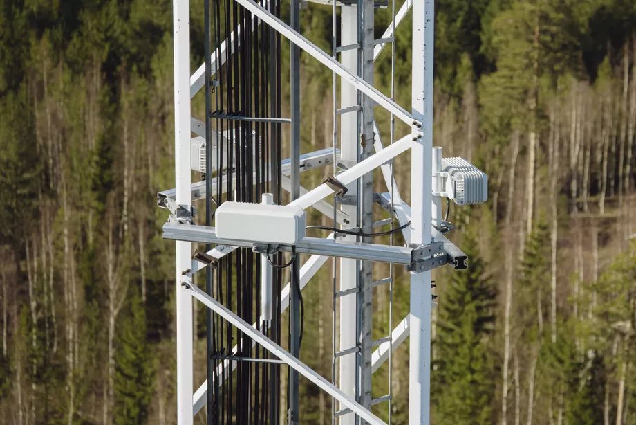
Finnish technology beats the F-35's stealth – detects it from almost 400 km away! Imagine this: A stealth fighter that is built to be invisible to radar… but Finnish brains from Saab in Tampere now have a small box that listens to it from almost 400 kilometers away. The news? The new Sirius Compact L24R device is being launched this week at the Electronic Warfare Expo in Helsinki. It is completely passive – it doesn't send anything, it just listens to all the electromagnetic signals on the battlefield. Unlike the old backpack variants (which a soldier could carry), the L24R is made to be screwed onto masts, windmills or tall buildings. A single cable, 65 watts, no cooling required. Three of them provide 360-degree tracking. And it pinpoints the direction with less than one degree of accuracy. Product manager Pekka Halme:
“We can detect signals better than with the tactical systems because we only look at a certain sector.” It can pick up radar signals from fighter jets (like the F-35 when the radar is on), commercial aviation weather radars and even ship navigation radars. Sales manager Mathew Wilmot boasted about how it can be built into a large, decentralized sensor network – and mentioned Finland’s southern coast and eastern border as an example. In other words: Russia can forget about sneaking in by plane or ship without the Finns knowing exactly where they are. And the best part? The system has already been sold to 10 countries. The irony is outstanding: You build an aircraft that is supposed to be invisible… and then a Finnish box comes along and says “hey, we can hear you anyway”. Stealth? More like “scream all the way”. What do you think – will this make both Russia and China sweat a little extra, or is it just another cool gadget in the electronic warfare? Source:
Saab Finland / Tampere Technology Centre – press briefing ahead of launch at AOC Europe, Helsinki (23–24 May 2026)
6
10
50
10,587

Quick correction. The calculated ground speeds in the earlier read were noise — Mode-S position deltas eating multilateration jitter near Al Dhafra and the Strait. Dropped them.
Same forensic move as the Kpler tapes. Name the garbage. Build only on what survives the transponder direct — squawk, barometric altitude, registration, position. The case is the same. The picture sharpens.
Three new cards on the receipt.


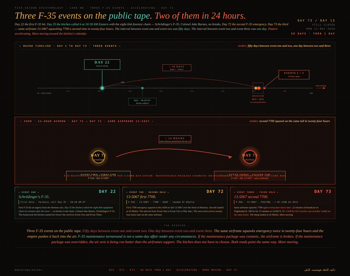
The five-second epistemology of third F-35A emergency on the kitchen's public tape — Tail 13-5067 broadcasting its callsign F35LTNG and squawking 7700 a second time in twenty-four hours, twelve minutes of one hundred knots ground speed at fourteen thousand nine hundred fifty feet inbound from where the KC-135R Stratotanker 62-3512 had just anchored east of Sohar over the Gulf of Oman in international airspace, the 1962-production tanker that keeps fifth-generation stealth strike capability airborne broadcasting its position openly on civilian internet while suppressing only its callsign, the asymmetry that names the operation, the structural diagnostic that the fifth generation does not fly without the second generation, the same airframe squawking emergency twice in one operational day, and the third receipt on the public tape with more receipts already moving
Day 73. Day 13. Strait still closed. The kitchen is reading the third F-35 receipt on the public tape.
The Flightradar24 frames for Day 73: F-35A Tail 13-5067, USAF, callsign F35LTNG, squawking 7700. Second 7700 on this same airframe in twenty-four hours. Ingress at 346 knots over Fujairah at 15,025 feet. Slow phase: one hundred knots ground speed at 14,950 feet for twelve minutes. Then 341 knots westbound across the Emirates, descending toward Al Dhafra. The thing landed. Five frames. iPhone clocks 10:34 through 10:46 UAE local. Same axis as Day 72. Same airframe as Day 72. Same code as Day 22 and Day 72. Third F-35 event on the kitchen’s tape.
§ I. THE HUNDRED-KNOT ANOMALY
F-35A clean-config stall at gross weight is approximately one hundred forty KIAS. At fifteen thousand feet, true airspeed runs about twenty-five percent above indicated. One hundred knots ground speed at cruise altitude is below clean stall. Three interpretations. Hard turn hiding ground speed — twelve minutes cannot be a hard turn. Approach configuration at 14,950 feet for twelve minutes — approach configuration is a final-mile state, not a cruise-altitude state. Damaged airframe trying to maintain controlled flight — pilot pulls back on power, deploys what control surfaces still work, hangs in the air at the slowest survivable speed while assessing what is left. Twelve minutes is how long it takes to figure out if you can make it home. The thing made it home. Pilots do not squawk emergency for controlled loiter. Pilots squawk emergency when the airframe is hurt and every other aircraft in range needs to know.
§ II. THE TANKER ANCHOR EAST OF SOHAR
The Flightradar24 frame includes a second airframe and the second airframe is the receipt. KC-135R Stratotanker, Tail 62-3512, USAF, callsign suppressed, ADS-B on. Came in from the west, parked in a racetrack east of Sohar over the Gulf of Oman, ran the anchor, returned westbound. That orbit is the gas station. That is where strike packages and CAP top off before pushing east into the Strait or recovering west into Al Dhafra. The F-35 came back from exactly that direction. From exactly that altitude band. Declared emergency coming back from where the tanker was parked. The tanker anchor and the F-35 emergency profile sit on the same axis. The kitchen has the operational picture in two airframes on one frame.
1
2
16
1,281

May 6
🧵 4/5
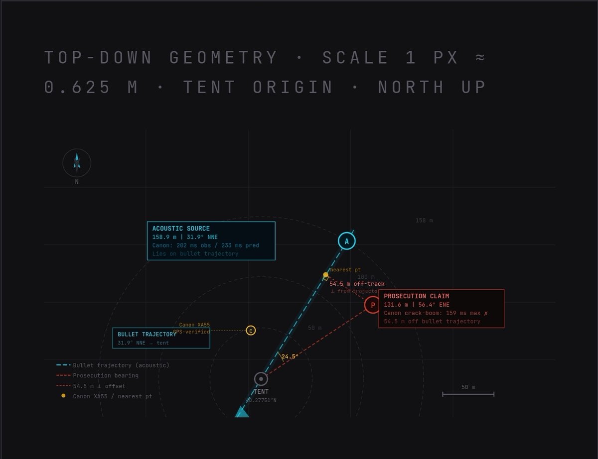
Five independent lines of evidence all converge on the same acoustic muzzle location:
✅ Crack-boom timing (20 recorders) → bullet velocity 2,783 fps
✅ TDOA multilateration (11 GPS recorders)
✅ Canon XA55 direct timing
✅ N-wave shockwave signatures
✅ Dr. Rob Maher’s independent CNN analysis
All of it contradicts the prosecution’s claimed position.
1
7
73
2,866
May 6
🧵 2/5
Prosecution claims the shooter was here:
📍 40°16′41.41″N 111°42′45.90″W
→ 131.6 m from tent at 56.4° bearing
Acoustic multilateration from 11 recorders puts the muzzle blast source at:
📍 40°16′43.4″N 111°42′47.0″W
→ 158.9 m from tent at 31.9° bearing
67.1 meters apart. 24.5° angular error.
5
11
73
1,966

On today series,
I have been working on a probabilistic physical context signal that uses the physics of signal propagation to establish individual probabilistic location without requiring GPS API, IP location servers.
Will provide more information when I wake up from sleep.
For now, if you are interested in seeing how this work, ensure to turn your notification on.
Ps. This project is so intriguing that whatever happens, I am so glad i hoped on it.
Now, I have tiny bit knowledge of WGS84 geodesy, optical physics, trilateration&multilateration, matrix alegebra and so much more.
How do I feel: Chilled, I just pray it works, the limitations are so constricting. But I'll still keep pushing.

1
1
13
362
Chisos!!!!
From Google Workspace automations to suddenly solving Trilateration and Multilateration with equatorial radius, polar radius, and radius of curvature in the prime vertical.
Who sent me on this geodesy project?
Ps. Will share the final outcome and write articles back to back once I survive this.

There's a kind of project you will do, you will understand that life is maths and physics, you can't escape.
Tell me how I ended up studying Trilateration because of this one project.
How do i explain it's automation and javascript .
How did i end up with geospatial mathematics, Haversine Formula, TCP 3 way handshake.
2
140


May 2
DePIN edge revolution incoming! 🚀
Neuron SDK no-code Builder = game-changer for IoT flows. @4dskyapp multilateration crushes aviation intel challenges.
Must-watch workshop replay now
@hedera @Neuron_World @4dskyapp
2
61
The plane that "couldn't be tracked" is 🇺🇸 #USAF C-17 Globemaster 08-8204 #AE2FB0, and its transponder was on the whole time. When they crossed over parts of Japan and Korea, 4 ground-based receivers picked up their Mode-S transponder and geolocated them using multilateration (#MLAT); they weren't transmitting their lat/lon position with ADS-B.
By not using ADS-B, they limit the range with which we can pick up their movements.
These two images represent similar aircraft (A C-17 vs a 747) at similar altitudes, using the same network of receivers (ADSBexchange) but the C-17 is being tracked by 4 receivers calculating its position every second using multilateration of it's Mode-S transponder transmissions, and the 747 is being tracked by one of those same receivers, receiving the plane's coordinates that he plane itself transmits using ADS-B out of a similar transponder.
You're looking at the practical difference in range between trusting a plane's transmitted position data in ADS-B (the 747 on the right), and calculating the position (direction/location finding) using multilateration (MLAT) of the Mode-S transponder (the C-17 on the left). Entirely different ways to track aircraft mixed up on the same map for your convenience, not your understanding.
Normies get duped pretty regularly with the "turned off their transponder" shtick because ADS-B aircraft nearby still show up, while Mode-S/MLAT aircraft "vanish". They don't know they're looking at two different ways of tracking planes with unrelated range/detection limits.
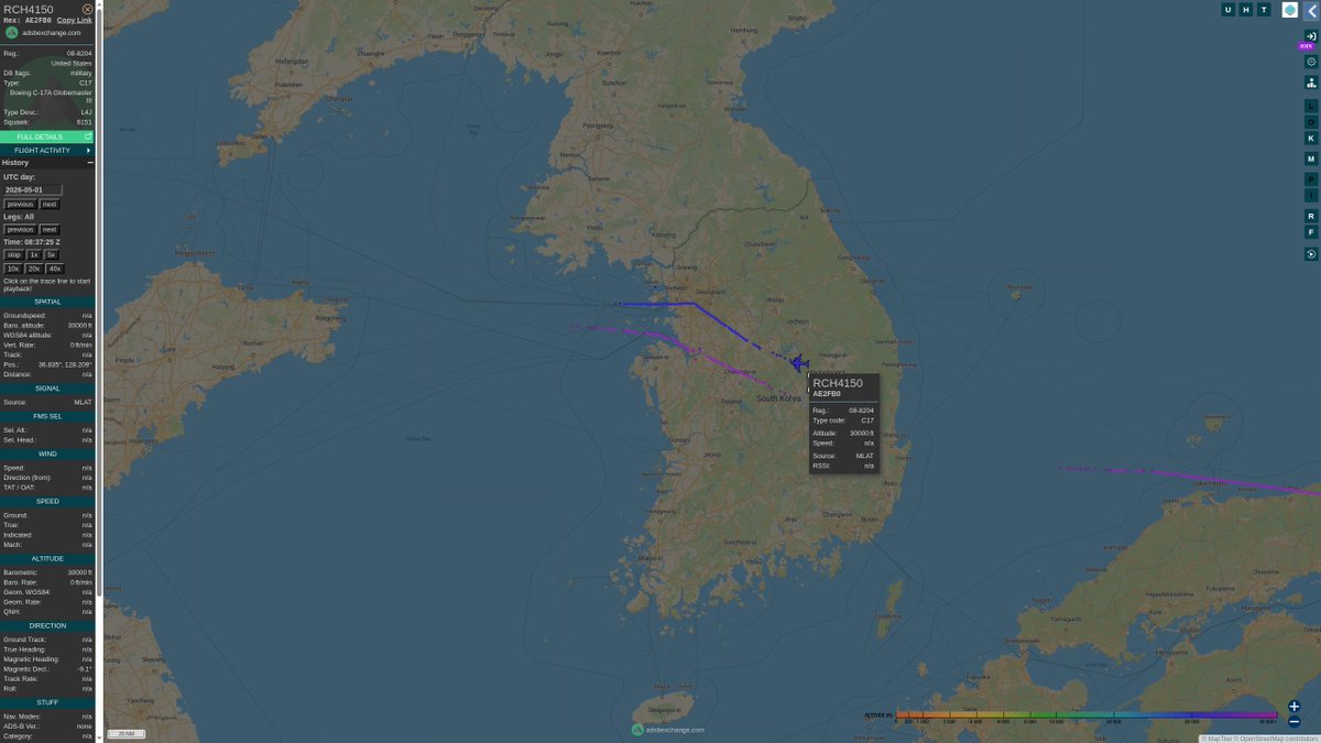
ALT https://globe.adsbexchange.com/?icao=ae2fb0&lat=36.755&lon=126.515&zoom=7.8&showTrace=2026-05-01×tamp=1777624646
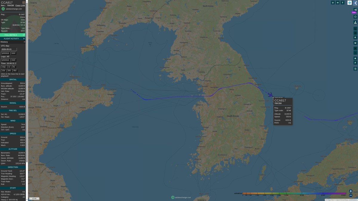
ALT https://globe.adsbexchange.com/?icao=780cb8&lat=37.056&lon=125.532&zoom=7.8&showTrace=2026-05-01×tamp=1777629632
May 2

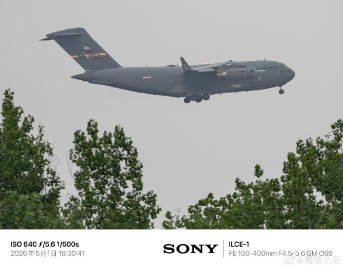
🇨🇳🇺🇸 A U.S C-17 was seen landing in Beijing after flying from Joint Base Andrews.
It flew with transponders switched off, meaning it couldn't be tracked.
It's believed to be carrying equipment for Trump's visit to China, scheduled for 14-15 May.
Source: CIG telegra
2
8
41
8,005

The country’s planned new surveillance infrastructure for air navigation services, including primary and secondary radar systems, an air traffic management system and wide multilateration, will cost about N$500 million, Namibia Civil Aviation Authority f.mtr.cool/edhnrbtfwx

2
229

Apr 26
There’s been some renewed talk & posts on X regarding the Audio analysis at UVU on 10 September 2025, the day of the Kirk Assassination! According to Grok Audio Engineers like Matthew Bowden @Freqazoid26 are not qualified to do this specific specialised work & their results it cannot be relied upon!
Grok says that it’s actually Physicists dedicated to a sub field of audio works in acoustics like “Forensic Acousticians” who would be used to do this work.
I’ve ask Grok and it’s not an Audio Engineer that we want but rather a physicist!
Part 1
Yes, physics has a dedicated subfield for audio work: acoustics (specifically physical acoustics or applied acoustics). Physicists in this area study how sound waves propagate, reflect, refract, and interact with environments—everything from pressure waves and shock waves to frequency analysis and environmental effects like temperature, humidity, and terrain on sound speed (~343 m/s in air at room temp, but adjustable for conditions).
Many specialize further in forensic acoustics (or forensic gunshot acoustics), which applies these principles to real-world investigations like crime scenes, shootings, or public incidents captured on video/phone audio. This is exactly the expertise needed for analyzing something like the audio from the Charlie Kirk assassination (September 10, 2025, at Utah Valley University, where he was killed by a single distant rifle shot).
What a Specialist in This Area Does for a Case Like This
For triangulating shooter positions, confirming reported (or “ported,” if that’s what you meant) locations, and spotting audio anomalies, you’d hire a forensic acoustician or audio forensics expert with a background in gunshot/ballistic acoustics. These professionals (often with physics, electrical engineering, or acoustics PhDs) use physics-based methods:
• Extract waveforms from multiple synchronized or unsynchronized recordings (bystander videos, podium mics, etc.).
• Identify key acoustic signatures: The sharp “crack” (supersonic ballistic shockwave from the bullet) vs. the later “pop” or muzzle blast. The time delay between them reveals range (e.g., ~240 ms delay can indicate ~150–200 meters for a .30-06 rifle like the one used).
• Time-of-arrival (TOA) or time-difference-of-arrival (TDOA) analysis: Measure tiny delays (milliseconds) in when the sound reaches different microphones. With 3 known mic positions (geolocated via video/GPS/Google Earth), they mathematically triangulate the source in 2D or 3D using multilateration equations. This accounts for sound speed, possible echoes, wind, buildings, etc.
• Confirm or refute reported positions: Compare calculated shooter location (e.g., specific rooftop ~130–160 m away) against eyewitness/video reports. Inconsistencies would show up as mismatched arrival times.
• Detect anomalies: Extra shots, multiple shooters (inconsistent timing or directions), suppressors (alters muzzle blast but not crack), echoes/reverberations, electronic anomalies (e.g., if audio was edited), or even if a “shot” was something else (explosion, firecracker). They model propagation in software to simulate what should be heard from a given position.
This is rigorous, court-admissible work—often involving calibrated tests with the same firearm/ammo in controlled conditions.
Who Specifically Would You Use?
• Academic or independent forensic acousticians: Top experts like Robert C. Maher (Montana State University professor and leading gunshot acoustics specialist). He has published extensively on forensic gunshot analysis, works with law enforcement/FBI, and has already publicly analyzed the Charlie Kirk audio (identifying the single supersonic rifle shot via the crack-pop signature).
@jonaaronbray @troofevades @MadMax84281 @EcologicalCrime @MuppetMasher @triggersmarthq @KeliRabon @PBInvestigate @TheLFLounge @baroncoleman @RealCandaceO @realstewpeters @realjesseonfire @danksterintel @alleytopfiles @researcherdaisy
@BlakeBednarz
5
1
3
453
Apr 25
He explains why human ears can't reliably localize a supersonic Mach cone, which is precisely why instrument-based multilateration across 11 cameras is the right method. It has zero relevance to instrument-recorded TDOA analysis.
1
2
31
926
Apr 21
🇨🇦🛩️🚁 Where have the Mode-S transponders of Ontario Ministry of National Resources aircraft identified themselves, or been geolocated by multilateration, in the past day, by the global ADSBexchange network of aircraft transponder receivers?

1
1
9
3,837
Apr 21
🇨🇦🚔🛩️🚁 Where have the Mode-S transponders of Ontario Provincial Police aircraft identified themselves, or been geolocated by multilateration, in the past day, by the global ADSBexchange network of aircraft transponder receivers?
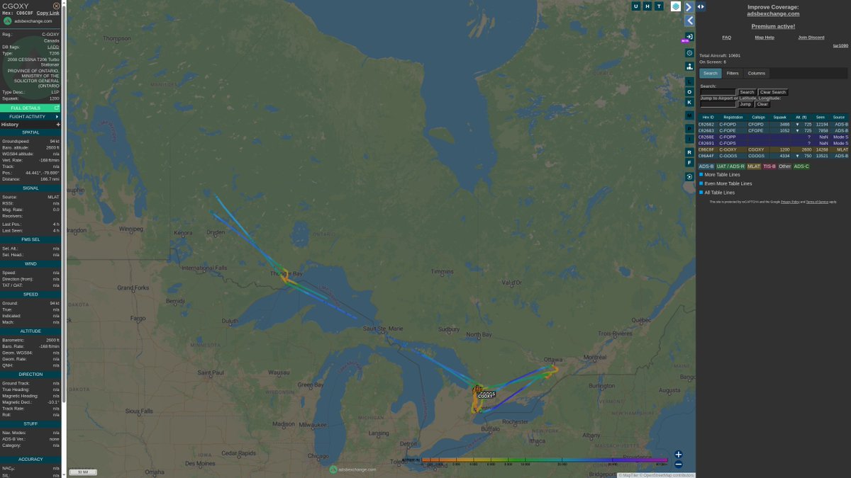
ALT https://globe.adsbexchange.com/?icao=c02682,c02683,c0268e,c02691,c06a4f,c06c0f
1
5
20
6,714
Apr 21
🇨🇦🚔🛩️🚁 Where have the Mode-S transponders of Royal Canadian Mounted Police aircraft (and contractors) identified themselves, or been geolocated by multilateration, in the past day, by the global ADSBexchange network of aircraft transponder receivers? #RCMP
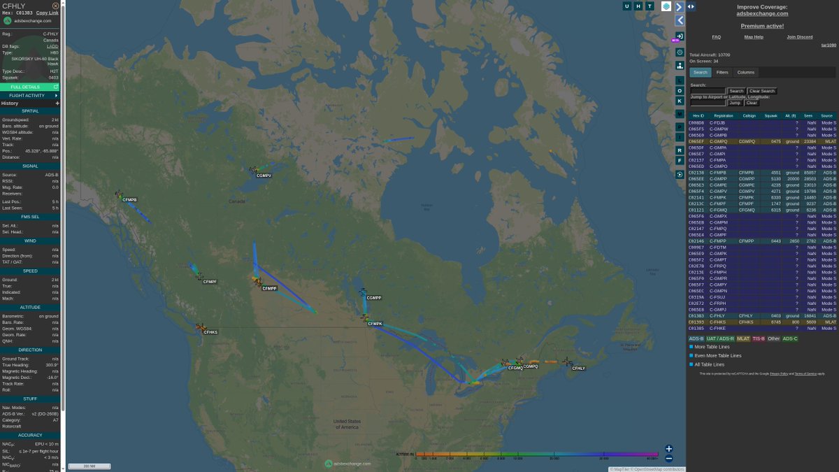
ALT https://globe.adsbexchange.com/?icao=c008d8,c065f5,c065e0,c065ef,c065df,c065e7,c02137,c065ed,c065f4,c01121,c02141,c065e3,c065f6,c065eb,c02147,c0213c,c065e4,c02146,c009e7,c065e9,c065f2,c02e7b,c0213e,c065ee,c065f0,c065f7,c02138,c065ec,c0319a,c02e72,c065e8,c01393,c013b3,c01385
1
2
13
3,394

Time for us to lock in and get the tracking turrets up sooner so we can go out to wallops and get multilateration 3D fix and hyperspectral track footage.

1
1
25
1,827

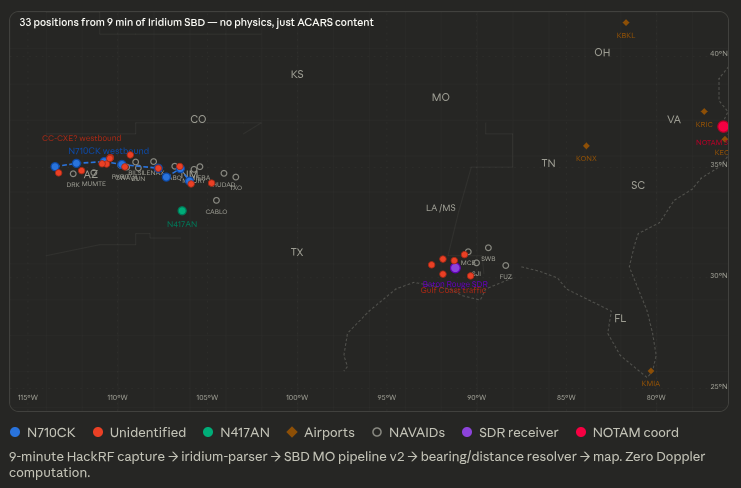
Apr 5
updating the Iridium ACARS rabbit hole…
here is the pipeline that extracts aircraft position directly from message content.
No Doppler.
No multilateration.
No satellite tracking.
Just parsing what the aircraft is already transmitting.
Repo:
github.com/mebrown47/iridium…
6
12
74
17,089