Large Horizontal Wall Art: Everything You Need to Know Before You Buy
.
woodenworldmap.net/blogs/new…
.
#woodmap #woodenmap #wallmap #largescale #wallart #2026wallart #Colorful #woodenworldmap #woodenworldmapnet #colorfulartwork #ColorfulWallArt
2

I’m making a huge paper wallmap with red lines as we speak 🗣️
4
63

28 Nov 2025
Compromise projections are almost certainly the best solution for the generic elementary school world wallmap. Triple Winkel, Robinson, etc.
Mercator’s not a great wallmap for that purpose, but its preservation of angle means it’s still very good and useful for zoomable maps like Google Maps.
Gall-Peters is not actually useful in most of the ways one might want to use a world map. The people who push it do tend to have a cheap ideological axe to grind which is not something elementary school students should have to deal with.

gall-peters is great if what you want is to compare area and for some unimaginable reason also need to compare longitude
in schools you want a compromise projection, like the robinson that was in most of my classrooms growing up
the soviets came up with the best one

2
2
31
2,719

12 Aug 2025
Homie was so disappointed when they said he couldnt colour the wallmap and frankly, I get it
12 Aug 2025

generation alpha don’t care about NONE of the materialistic stuff that their parents and their parents parents cared so much about.. it’s quite refreshing if you ask me
2
110

27 Jun 2025
I NEED HELP!
who has Nigeria Oil and Gas wallmap
which contains
-Which operators are active in the region
-The location of the main oil and gas fields
i dont mind paying but sigh its urgent
3
2
255

13 Feb 2025
【音なし】
昔ながらの純粋なWallMap、たまにやりたくなる✨
We'll Meet Again (c767) Ex
TheFatRat & Laura Brehm [Reddek]
Index / tracker×6 (no knees) 1.34.2
Avatar:櫻歌ミコ
1
32
460


16 Nov 2024
このように簡単なのですが、intmapには「壁の右側の色」を持たせていたのですが、(1,x,c)クエリの際に
IntMap.insert leftwall c wallmap
とすべきところを
IntMap.insert x c wallmap
としてしまい1WA。
1
2
33

10 May 2024
#roadtrips to see #waterfalls in #Texas . Stop by Hawkes Outdoors and see our #wallmap with interesting #outdoor places to have some #fun
1
2
225

territorios
Y sentarse con esa repudiable actitud paternalista patronal para decirnos que hacer
Después de esto
Lo que tú decidas hoy
Será la herencia que dejarás
Para tus hijos y los hijos de tus hijos
Es tu decisión
Luchar por la liberación de nuestra nación Mapuche WALLMAP
1
1
1
115

22 Nov 2023
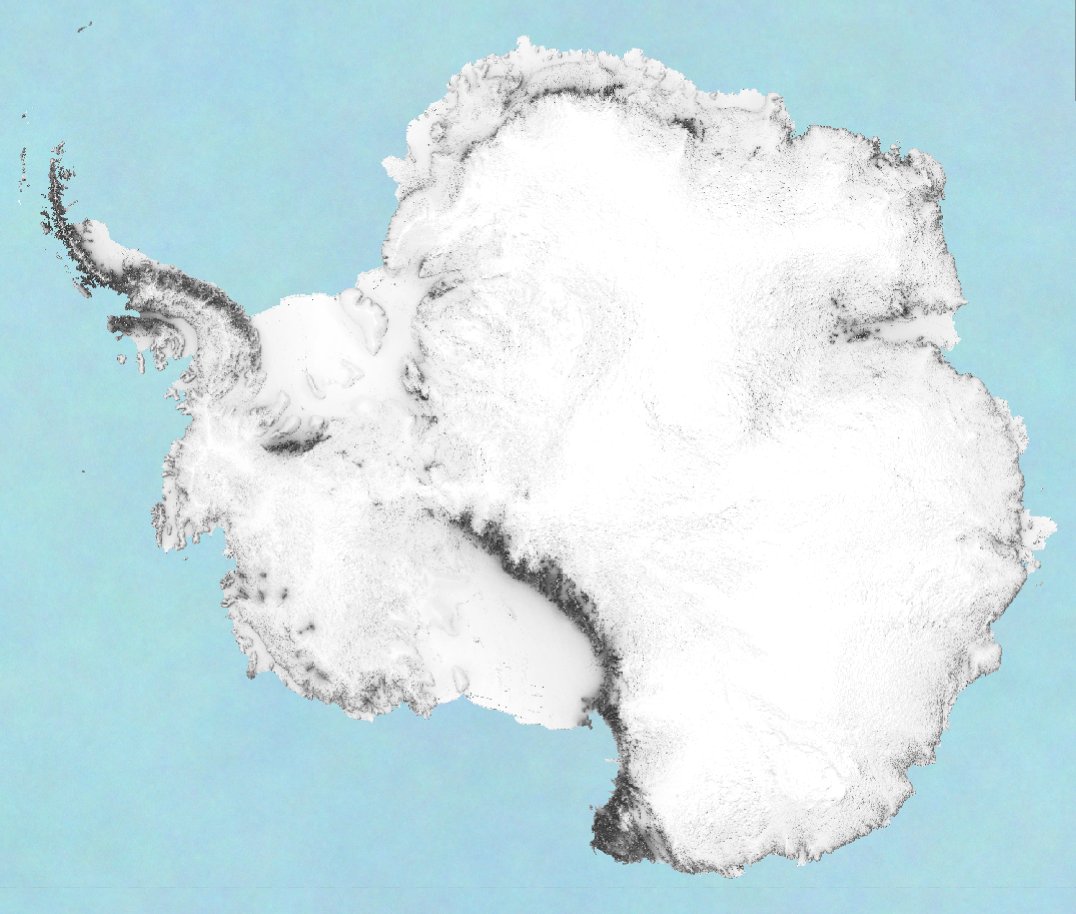
#30DayMapChallenge | Day 22 | North is not always up | Diagonal panning over a very detailed shaded map of Antarctica | From the South Pole, North is up, down, left, right, any direction! #shadedmaps #shadedrelief #antarctica #southpole #wallmap #wallart #dem #elevation #LiDAR
1
3
220
22 Nov 2023
#30DayMapChallenge | Day 22 | North is not always up | Diagonal panning over a very detailed shaded map of Antarctica | From the South Pole, North is up, down, left, right, any direction! #shadedmaps #shadedrelief #antarctica #southpole #wallmap #wallart #dem #elevation #LiDAR
1
2
150
22 Nov 2023
#30DayMapChallenge | Day 22 | North is not always up | A very detailed shaded map of Antarctica | From the South Pole, North is up, down, left, right, any direction! #shadedmaps #shadedrelief #antarctica #wallmap #wallart #dem #elevation #art #geography #cartography
1
2
159
12 Nov 2023
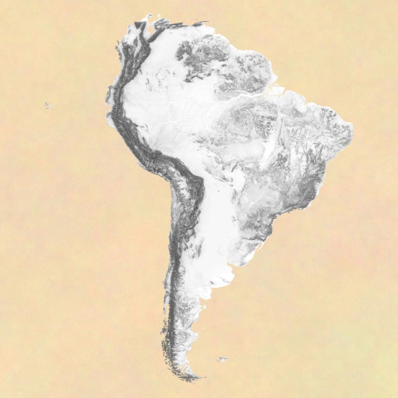
#30DayMapChallenge | Day 12 | South America | A very detailed shaded map of South America [32000 x 32000 pixels] #shadedmaps #shadedrelief #southamerica #wallmap #wallart #dem #elevation #art #geography #cartography #digitalcartography #map #maps #mapping
1
7
273

3 Nov 2023
Discover Luxury Wall Art for Elegant Home Decor
.
woodenworldmap.net/blogs/new…
.
#woodmap #woodenmap #wallmap #wallart #autumndecor #falldecor #luxurywallart #luxury #naturalart #wallart #woodenworldmap #woodenworldmapnet
1
1
35

Can't go wrong with that. I have both editions. Make sure it has the wallmap or get a good copy online.
2
3

20 Oct 2023
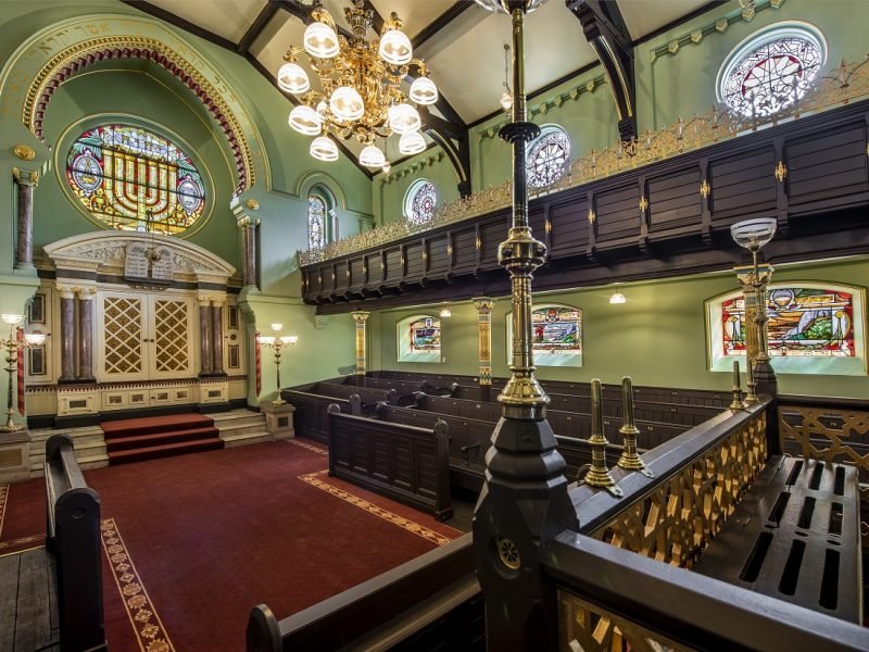
Though the terrorists and anti-Semites try to defeat us...though the Owen Jones-Gary Lineker-Steve Coogan luvvies mock us, we stand firm.
"Jewish Manchester", free tour, Sunday 22 Oct, 2pm from. Victoria Station wallmap. @visit_mcr
@VisitSalford
1
1
2
265
28 Sep 2023
Autumn Elegance: Fall Office Decor Ideas
.
woodenworldmap.net/blogs/new…
.
#woodmap #woodenmap #wallmap #wallart #autumndecor #falldecor #autumn #officedecor #office #homeoffice #wallart #woodenworldmap #woodenworldmapnet
1
1
27
21 Sep 2023
Modern Fall Decor Ideas to Transform Your Home in 2023
.
woodenworldmap.net/blogs/new…
.
#woodmap #woodenmap #wallmap #wallart #autumndecor #falldecor #autumn #giftidea #map #wallart #woodenworldmap #woodenworldmapnet
1
2
27

13 Sep 2023
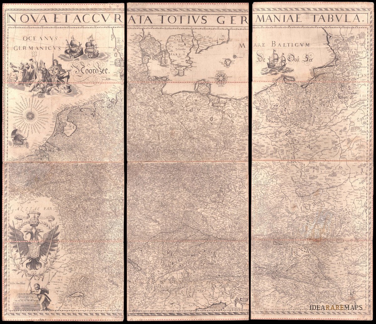
An exceptional 1639 Blaeu's #wallmap of the German Empire showing the #Netherlands, #Germany #Switzerland, #Austria, #Bohemia, #Moravia, and #Poland. Only three other copies are known to Schilder. My preferred map in the new catalogue!
4
280