
Jun 15
The Skies Unleash Fury: A Case Study of Severe Weather on June 14, 2026
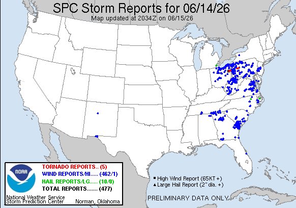
On June 14, 2026, a cold front triggered scattered severe thunderstorms across the Ohio Valley, western and central Pennsylvania, and into the Mid-Atlantic. Although not a major tornado outbreak, the event produced damaging winds, isolated tornadoes, and significant local impacts under a Slight Risk outlook from the Storm Prediction Center.
Storms organized into lines and moved east during the afternoon and evening. In Pennsylvania, a tornado touched down near Punxsutawney in Jefferson County around 5 p.m., with video confirming a funnel cloud and numerous trees downed. Multiple tornado warnings were issued for Beaver, Lawrence, Butler, Allegheny, and Westmoreland counties, including Pittsburgh suburbs. In Ohio, a 90 mph wind gust was recorded in Columbiana County, and a trained spotter reported a funnel cloud. Severe thunderstorm warnings noted 60 mph winds and small hail across the region.
Storm reports highlighted widespread tree and branch damage in areas such as Ambridge, Beaver Falls, and Somerset County. Power outages affected tens of thousands, with nearly 19,000 customers impacted in Allegheny and Beaver counties alone. Storm chasers and spotters played a vital role, providing real-time visual confirmation of rotation and funnels that supported warning decisions during fast-moving linear segments.
This event contrasted sharply with the June 10–11, 2026, tornado outbreak in Illinois and Indiana, which featured numerous discrete supercells and at least 17 confirmed tornadoes, including an EF3. June 14 emphasized straight-line winds from organized lines rather than prolific tornadic activity, a pattern common during transitional summer frontal passages in the Ohio Valley and Mid-Atlantic.
The episode demonstrated the importance of spotter networks and chaser reports even on lower-risk days. While tornado threats remained isolated, wind damage and power disruptions created meaningful community impacts. It served as a reminder that preparation and vigilance are essential regardless of outlook category, as the atmosphere can still deliver significant localized hazards.
#SevereWeather #StormChasers #TornadoWarning #WeatherCaseStudy #NWS #WindDamage #SevereStorms #WeatherAnalysis
1
102
Jun 14
The Dynamic Skies of June 13, 2026: A Case Study of Severe Weather Across the Central United States
On June 13, 2026, the central United States experienced a significant severe weather event. Scattered supercells evolved into a destructive squall line, bringing damaging winds, large hail, isolated tornadoes, and flash flooding. The episode highlighted rapid convective changes and the critical role of storm chasers and ground observers.
Meteorological Setup
The Storm Prediction Center issued an Enhanced risk for central and eastern Kansas, western Missouri, northeastern Oklahoma, and nearby areas. Primary threats were damaging winds, large hail, and a limited tornado risk. A cold front combined with instability and shear supported afternoon supercells that later organized into a linear mesoscale convective system.
Storm Evolution and Hazards
Storms began as localized clusters and intensified through the afternoon. By evening, they consolidated into a squall line that produced the main impacts.
• Tornadoes: A radar-confirmed tornado tracked through Missouri City, Liberty, and Excelsior Springs, Missouri. A visible landspout formed in Kansas and was observed directly by National Weather Service staff at Dodge City around 5:45 p.m. CDT.
• Hail: The largest hail measured 2.75 inches near Taylor, Nebraska.
• Winds: Peak gusts reached 96 mph northeast of Eva, Oklahoma, and 90 mph in Amarillo, Texas, with widespread damaging winds across the region.
• Rainfall and Flooding: Intense rates caused flash flooding, including 4 inches in one hour at Humansville, Missouri, and 5.61 inches in 12 hours at Hartville, Missouri.
Tornado watches covered parts of Kansas and Missouri, while numerous severe thunderstorm warnings were issued.
Field Reports and Impacts
Storm chasers provided essential real-time information. Live coverage documented the tornado-warned storm near Liberty, Missouri, and chasers tracked the shift from discrete cells to the squall line. National Weather Service personnel directly observed the Kansas landspout, and spotters reported hail sizes, wind damage, and rainfall totals that supported warning updates.
Impacts included downed trees and power lines from strong winds, localized damage along the Missouri tornado path, hail damage to property, and flash flooding in Missouri. In the Mid-Atlantic, gusts over 60 mph caused a building collapse, confirming the reach of linear convective threats.
Historical Context
This event differed from the June 11, 2026, outbreak, which featured multiple strong tornadoes across the Midwest. June 13 emphasized widespread straight-line winds within an organized squall line and isolated tornadoes. It aligned with classic High Plains patterns, where high-based storms generate intense outflow winds and occasional landspouts. The realized tornadoes despite modest probabilities illustrated the “sneaky” nature of boundary-enhanced threats seen in prior similar episodes.
Key Takeaways
The June 13, 2026, event demonstrated the atmosphere’s rapid evolution from supercells to a linear system. Damaging winds dominated, accompanied by hail, isolated tornadoes, and flooding. Storm chasers and spotters delivered vital observations that enhanced warnings and public safety.
This case study reinforces the need for preparedness across all hazard types and the continuing importance of integrated observation networks in understanding and mitigating severe weather.
#SevereWeather #StormChasers #Tornadoes #DamagingWinds #LargeHail #SquallLine #WeatherCaseStudy #Meteorology #WeatherAnalysis #StormReports #NWS #HistoricalWeather #CentralPlainsWeather #MissouriValleyStorms #June2026Weather

76
Jun 13
Unrelenting Skies: The Severe Weather Event of June 12, 2026
On June 12, 2026, severe thunderstorms produced a focused outbreak of damaging winds across the Mid-Atlantic and Northeast, with scattered activity extending into other regions. According to the latest preliminary Storm Prediction Center (SPC) storm reports map, the day yielded 209 total reports: 1 tornado report, 194 wind reports (including 5 high-wind reports of 65 knots or greater), and 14 hail reports (including 1 large-hail report of 2 inches or greater). This distribution confirmed a predominantly wind-driven event rather than widespread tornadic activity.
The Meteorological Setup
A hot, humid air mass ahead of an advancing cold front fueled organized lines of thunderstorms that tracked eastward overnight from June 11 into the early morning of June 12. These linear systems generated straight-line winds frequently exceeding 60 mph, with localized gusts reaching or surpassing 70–80 mph. While the previous day featured multiple strong tornadoes, the June 12 threat centered on damaging winds and isolated hail, with only minimal tornado potential.
On-the-Ground Impacts and Reports
The heaviest concentration of wind reports clustered across the Mid-Atlantic and Northeast, where straight-line winds downed trees, damaged outbuildings, and caused power outages. In western Ohio, National Weather Service surveys confirmed straight-line winds of 60–70 mph that produced roof damage to barns, snapped trees, and downed power lines and poles. Similar wind impacts extended into parts of the Northeast, with five reports of winds meeting or exceeding high-wind criteria.
Hail reports remained limited and scattered, with one instance of large hail (2 inches or greater). The single tornado report was isolated and did not produce significant damage in initial assessments. Overall, the event resulted in localized infrastructure disruptions but no widespread fatalities directly attributed to the June 12 storms.
Storm Chasers and Real-Time Documentation
Storm chasers and spotters operated across the affected regions, particularly in the Northeast and Mid-Atlantic, where live coverage documented the linear storm structure, gust fronts, and lightning activity. Their observations aided in distinguishing wind damage from any embedded rotation and provided timely visual confirmation that supported National Weather Service warnings. Footage and reports highlighted the organized nature of the squall line as it progressed eastward.
Historical Context and Comparisons
The June 12, 2026, event aligns with patterns seen in prior mid-June severe weather episodes, such as the notable 2017 outbreak across the High Plains, where organized storms under a moderate risk produced significant wind and tornado damage. While the 2026 June 11–12 period collectively generated nearly 1,500 severe reports over multiple days—one of the more active stretches of the season—the June 12 focus on straight-line winds in the East differed markedly from the prolific tornado production of June 11. With the national tornado count already exceeding 700 for 2026 and 12 confirmed tornado-related fatalities year-to-date, these clustered days illustrate the variability and intensity possible even outside peak spring months.
Looking Ahead
Preliminary data continue to be refined through ongoing National Weather Service surveys. The June 12, 2026, severe weather event underscores the atmosphere’s ability to sustain organized, wind-dominant threats following days of higher tornado risk. Effective warnings, public preparedness, and the contributions of storm spotters and chasers once again helped limit greater impacts. Affected communities are now focused on recovery and restoration.
The skies may quiet in the near term, yet these events reinforce the importance of vigilance and respect for nature’s power.
#SevereWeather #StormChasers #WeatherCaseStudy #StraightLineWinds #SPCReports #NWS #SevereStorms #Meteorology #TornadoReports

105
Jun 12
The Destructive Force of June 11, 2026: A Midwest Tornado Outbreak Case Study
On June 11, 2026, a potent severe weather outbreak swept the Midwest, generating at least 17 tornadoes, widespread damaging winds, and large hail. Northern Illinois and northwest Indiana experienced the most significant destruction, with strong tornadoes leveling homes, triggering dramatic rescues, and causing widespread power outages. The event highlighted both the accuracy of forecasts and the critical role of spotters and storm chasers in protecting lives.
The Storm Prediction Center had issued a Moderate Risk for severe thunderstorms across eastern Iowa, northern Illinois, and southern Wisconsin, with threats extending into northern Indiana. Forecasters anticipated damaging winds over 75 mph, large hail, and several strong tornadoes. These conditions materialized as supercells developed ahead of a cold front, producing multiple tornadoes throughout the afternoon and evening.
A Tornado Emergency was issued for Woodford County, Illinois, after spotters confirmed a large tornado near Low Point. Destructive tornadoes struck Streator, Illinois, where homes were severely damaged or destroyed, roofs were torn off, and gas leaks occurred. Additional strong tornadoes impacted areas near Washburn and Dwight, Illinois, and Hebron, Indiana. Storm chasers documented wedge and sidewinder tornadoes, close-range crossings, and debris fields, while also assisting in rescues. In Streator, emergency crews extracted a trapped resident with a broken leg amid the rubble; four people sustained minor injuries overall. Post-event teams assessed damage on the ground as surveys began.
The outbreak contributed to more than 650,000 power outages across the Midwest and Northeast. One fatality occurred in Iowa from a fallen tree during morning storms. No tornado-related fatalities were reported in Illinois or Indiana.
This event shares key characteristics with other Midwest outbreaks, notably the March 10–12, 2026 outbreak that produced 106 tornadoes across a wider region. Both featured supercell-driven strong tornadoes and wind damage in Illinois and Indiana, underscoring the area’s recurring vulnerability. While June events of this intensity are less common than spring outbreaks, the June 11 setup demonstrated similar atmospheric patterns capable of significant localized destruction.
National Weather Service teams continue damage surveys to determine official ratings. The outbreak reinforces the value of timely warnings, spotter networks, and rapid community response. It serves as a clear reminder of severe weather’s power and the importance of preparedness in minimizing harm.
#SevereWeather #TornadoOutbreak #MidwestStorms #TornadoEmergency #StormChasers #NWS #SevereStorms #WeatherCaseStudy #TornadoSafety #June2026Weather

1
244