
30 Aug 2023
What’s a ‘jökulhlaup’?! A sudden glacial outburst flood, such as is happening now in Iceland along the Skaftá river, triggered when ice reserves beneath Vatnajökull glacier burst.
icelandreview.com/nature-tra… #geographyteacher #Iceland #glaciers #coldenvironments
2
8
1,214

16 Oct 2022
Frozen Planet II is a good one tonight. #coldenvironments #climatechange #feedbackloops #tippingpoints
2
12 Oct 2022
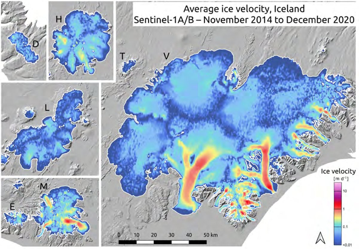
Satellite imagery and GIS are so useful for teaching geographical concepts and bringing locations or place change to life. Here we have examples of monitoring of ice dynamics:
#geographyteacher #coldenvironments #glaciers #Iceland

New article in Jökull Journal: "Continuous monitoring of ice dynamics in Iceland with Sentinel-1 satellite radar images" by @JanWuite et al. → jokull.jorfi.is/wp-content/u…
2
2
29 Sep 2022
Our free 'How to speak like a glaciologist' resource supports keyword literacy for GCSE and A Level. Try it here for free, as a boost to support geographic understanding of tier 3 vocabulary.
bit.ly/2LCrtt8
#geographyteacher #literacy #glaciers #coldenvironments
2
2
12 May 2022
Are your students revising glaciology? We have free assessment mats you can set for use in class or as home work, focusing on testing application of knowledge of glacial processes, landscapes and landforms. bit.ly/2BtV0jN
#geographyteacher #glaciers #coldenvironments
1
2
3 May 2022
Revision time again? We have free assessment mats you can set for students for in class or homework, focusing on testing application of knowledge of glacial processes, landscapes and landforms. bit.ly/2BtV0jN
#geographyteacher #glaciers #coldenvironments
1
3

17 Jan 2022
Thanks to David for sharing. I knocked up one of those guided reading tasks for Key Stage 3 which can be found here: docs.google.com/presentation… #geographyteacher #coldenvironments
This tweet is unavailable
4
23 Jun 2021
The Antarctic Treaty has just celebrated its 60th anniversary. The question is: is the treaty still relevant today? What has changed over time, and what challenges are there now?
theconversation.com/the-anta…
#geographyteacher #Antarctica #AntarcticTreaty #coldenvironments #geogchat
1

27 Nov 2020
Exploring the characteristics of #coldenvironments & the threats that these areas face? Discovering the #arctic from @RGS_IBGschools have some great #resources for students to investigate these challenges with activities, images, video clips & fact sheets. ow.ly/sql950Cn2g2
1
4
21 Oct 2020
A fantastic interactive graphic from @Reuters for your #geographystudents to learn about permafrost and the role it plays in the climate crisis.
ow.ly/qQ6G50BXrsw
#coldenvironments #geographyteacher #geography #teachertwitter
2
5
12 Oct 2020
Have you seen our free resources for use in the classroom, or for online learning? For example: How to speak like a glaciologist - key terms and definitions suitable for KS3 GCSE and A Level discover-the-world.com/study… #geographyteacher #glaciology #coldenvironments
2
24 Sep 2020
There is a daring plan to save the Arctic ice with glass - courtesy of @BBC bbc.com/future/article/20200…
#geographyteacher #climatechange #coldenvironments #Arctic
3
2


30 Jun 2020
Amazing geography right there. This process is called calving which I’ve always found hilarious. Whoever thought to name it like giving birth the a baby cow 😂🐄 #coldenvironments is my favourite topic ever 💕
This tweet is unavailable
5
18
29 Jun 2020
Need a resource for teaching glaciology? We have a new freebie for you: How to Speak Like A Glaciologist. With two different levels of challenge (conversational & professional) aimed at KS3-5.
discover-the-world.com/study…
#geographyteacher #glaciology #coldenvironments
2
5

5 Dec 2019
A fascinating story, esp being written in #Inuktitut.
Amazing photography #GIS
@PeterGWeather @tomheapmedia @gm0hcq @ed_hawkins #GeographyTeacher #Biomes #Ecosystems #IndicatorSpecies #ColdEnvironments #Sustainability
via @AllenCarroll
English version:
storymaps.arcgis.com/stories…

Even cooler, with the great help of @dougchiasson and WWF Canada, we got this StoryMap translated into Inuktitut. Check it out! @ArcGISStoryMaps storymaps.arcgis.com/stories…
1
3
2

7 Oct 2019
Great ideas for TV viewing this week. #coldenvironments #rivers #ecosystems #global-governance @CampdenSchool #InspireEmpowerExcel
6 Oct 2019

Couldn't fit everything on this week but here are the #geogglebox highlights for the week 🌍📺 JC

2
7
24 Apr 2019
Are you teaching about volcanic landscapes, cold environments, or islands? This stunning drone video introduces the wild beauty of Iceland. icelandmag.is/article/watch-… #Iceland #geographyteacher #volcanoes #distinctivelandscapes #coldenvironments
2
2
17 Apr 2019
The impact of global warming on #coldenvironments - thawing of permafrost in the Arctic region causing landslides.
theconversation.com/thawing-… #geographyteacher #Canada #globalwarming #climatechange
5
3

8 Mar 2019
@StrathallanSch #FourthForm #AQAGCSEGeography investigating #ColdEnvironments welcomes #Svalbard from #PolarNight into #PolarDay @visitsvalbard #UniqueLight
4