
4 Dec 2025
😲Tired of high - cost & limited vehicle - type identification methods? Traditional ways face issues like incomplete road coverage! A new paper has a breakthrough✨ It uses spatial - semantic info from GNSS trajectory data. This method with adaptive micro - trip segmentation outperforms fixed - size ones. Classification accuracy of coaches, trucks is higher than passenger cars! 🚗🚚
#VehicleTypeIdentification #SpatialSemanticInfo #GNSSData #TrafficTech #ResearchBreakthrough
Link[doi.org/10.1080/10095020.202…]
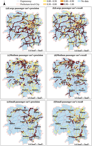
ALT Figure 10. Spatial distribution map of vehicle classification precision (case study 2: large, medium, and small passenger cars).
1
4
28
1,242

17 Dec 2024
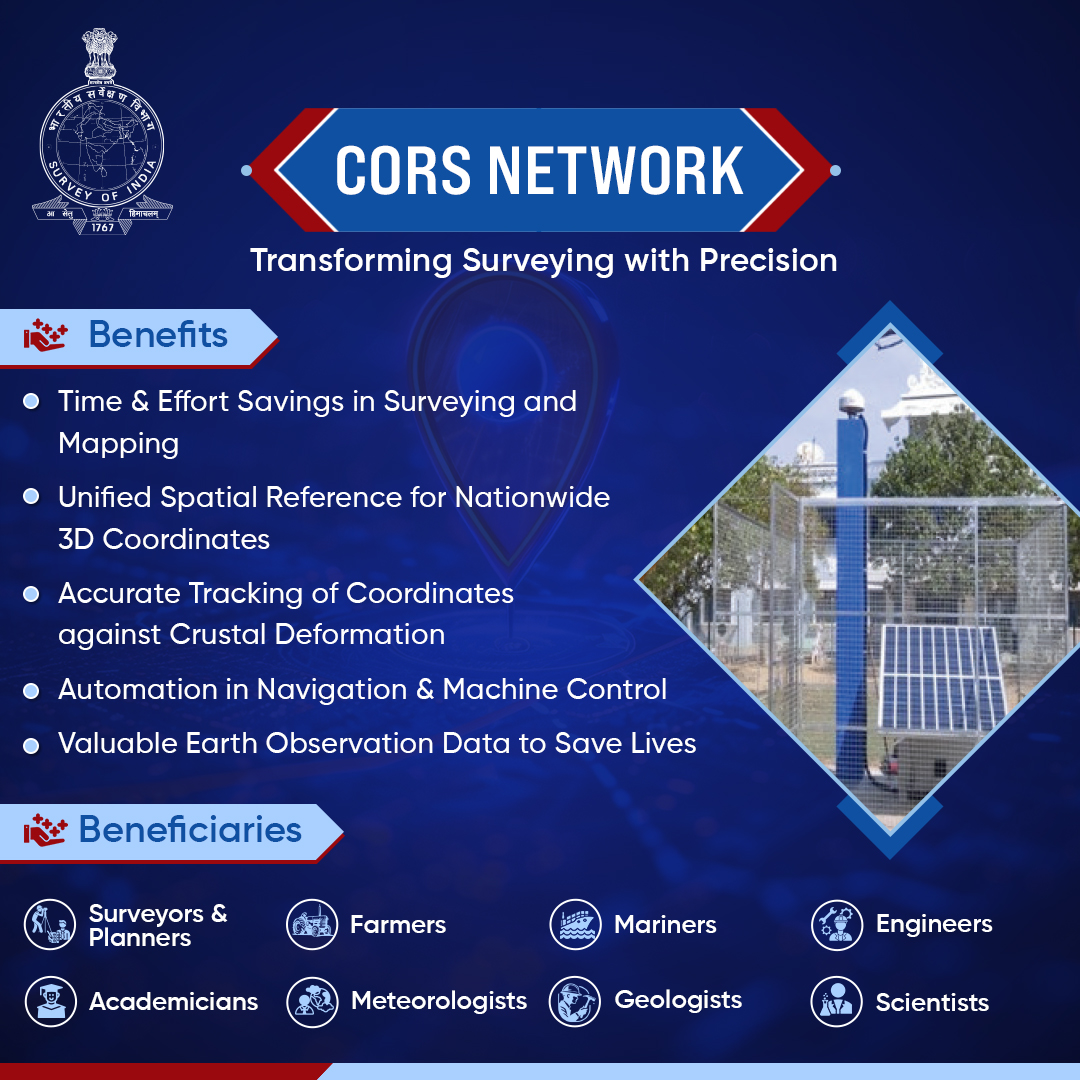
The Survey of India's CORS Network is transforming the landscape of surveying and mapping with unmatched precision. Comprising a robust infrastructure of Geodetic-grade GNSS receivers, these stations are strategically distributed across the region, continuously collecting GNSS data to provide high-accuracy positioning services. Available 24/7, 365 days a year, the network ensures real-time data and corrections through open, non-proprietary streaming standards, making it easily accessible to users.
Supporting the National GeoSpatial Policy 2022, the CORS Network plays a key role in providing efficient access to high-quality location data, enabling surveyors to achieve greater measurement accuracy. This results in more reliable and precise outcomes across a wide range of applications. Additionally, the network helps track crustal deformation, offering valuable insights for earthquake and landslide monitoring, thereby improving disaster preparedness and response.
The CORS Network serves various sectors, from farmers and engineers to geoscientists, by facilitating precision agriculture, supporting infrastructure development, and advancing critical research.
To access real-time CORS data and services,
Visit: cors.surveyofindia.gov.in
@DrJitendraSingh @karandi65 @IndiaDST
#SurveyOfIndia #CORSNetwork #GeospatialInnovation #GNSSData #PrecisionSurveying #NationalGeoSpatialPolicy #LocationData #GeoscienceResearch #CORSData #GeoTechnology
3
2
10
151

12 Jun 2024
🛰️When GNSS receivers receive satellite signals, they can store or output them with different GNSS data formats, such as RINEX, RTCM, and NMEA. Each format plays a vital role in various GNSS applications.
🔗 Learn more here: tersus-gnss.com/tech_blog/Di…
#TersusGNSS #GNSSData #TechBlog

1
2
84

2 Aug 2023
It's 10pm, do you know where your RTK prototypes are? 🔧🛰️🎯
We juuuuust plugged in this uBlox RTK F9P shield into USB and given the intense cost of these modules digikey.com/en/products/deta… we definitely had a nervous twitch but then we heard the "ba-dunk" of enumeration and wheeeewww it came up as a serial port. Heartened, we soldered on a right-angle SMA connector adafruit.com/product/1865 and connected a chonky active antenna digikey.com/en/products/deta… . Start up a copy of u-center and huzzah, there is GNSS data streaming out. Next up, we have to figure out what we want to use as the underlying transport layer from base station to rover - maybe an ESP32-S3 Metro adafruit.com/product/5500 and ESP-Now? more research is needed!
@ublox
#adafruit #ublox #rtk #electronics #opensource #opensourcehardware #zedf9p #ublox #arduino #prototyping #precisionlocation #uart #i2c #engineeringlife #gpsmodule #hardwarehacking #gnssdata #projectprogress #electronicsdesign #metrominute #esp32s3 #prototypebuilding
1
22
132
18,935

20 Jul 2022
.@GMESAfrica @TrimbleNews @LeicaGeosystems #AFREF2022Edition
#Day3 The trainees are focusing on #GNSS augmentation systems &availability in Africa, #GNSSdata,formats & conversions,(#Vendorformats, #RINEX #RTCM #BINEX #conversions2RINEX)& country presentations on status of #CORS

5
17