
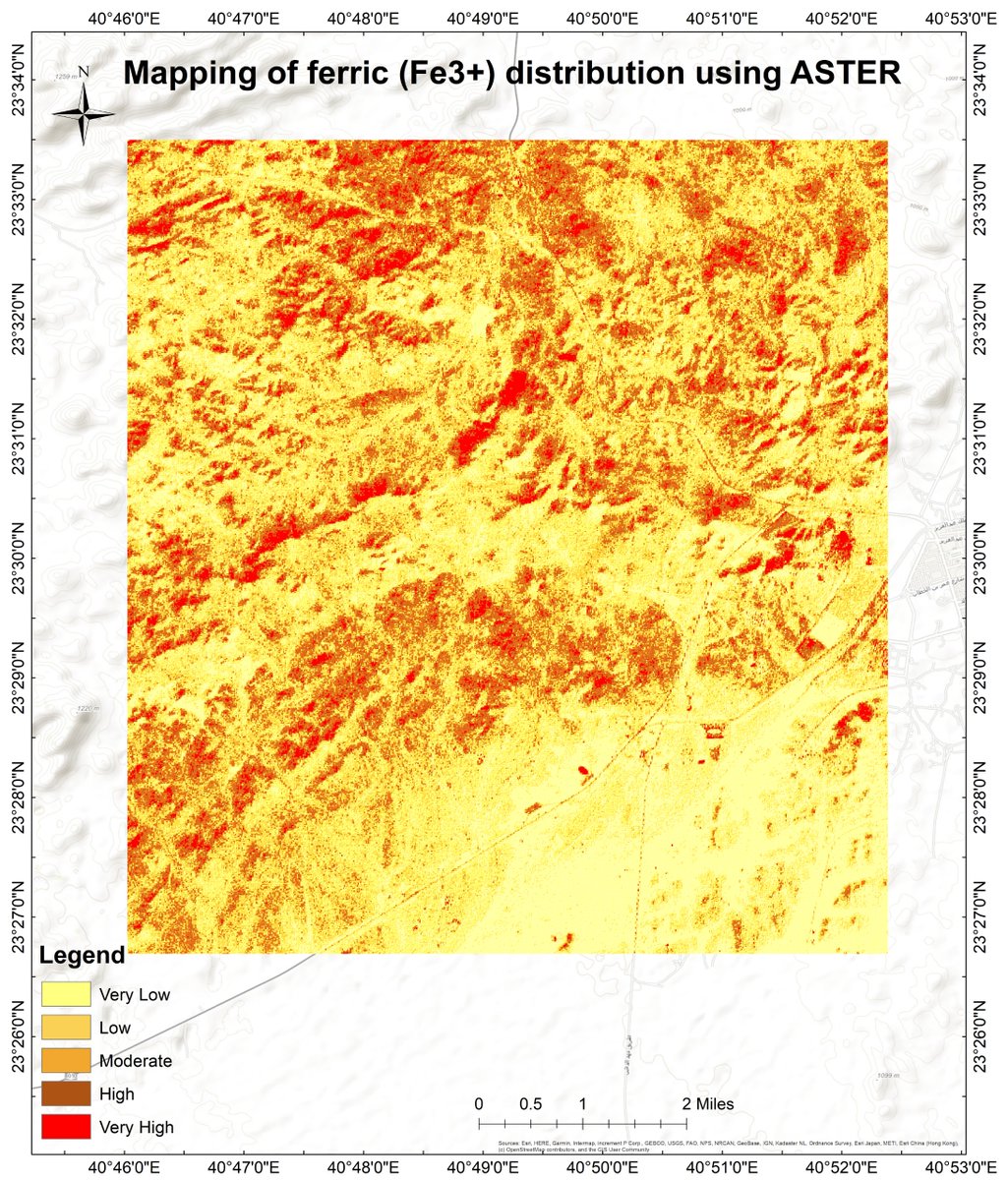
🛰️ Mapping Ferric Iron (Fe³⁺) from Space!
Check details:
linkedin.com/feed/update/urn…
#RemoteSensing #MineralExploration #ASTER #GIS #Geology #Mining #Geospatial #EarthObservation #MineralMapping #SatelliteData #Fe3 #HydrothermalAlteration #SpatialAnalysis #Geoscience
8
223

LAST DAY to submit your abstract for the 2026 GPN MAC Convention! ⏳
Visit GPNMAC.ORG
#GIS #Geospatial #Mapping #SpatialAnalysis #GISCommunity gpnmac26-urisa.hub.arcgis.co…

3

Jun 12
📍أحد أكبر الأخطاء في التعامل مع الذكاء الاصطناعي هو النظر إليه كأداة لتسريع العمل فقط. في مجال نظم المعلومات الجغرافية (GIS)، إذا استخدمنا الذكاء الاصطناعي فقط لإنتاج خرائط أسرع أو تقارير أسرع أو تنفيذ التحليلات بشكل أسرع، فإننا سنحصل على نتائج أفضل قليلاً، لكننا لن نُحدث تحولاً حقيقياً!!
📌القيمة الحقيقية للذكاء الاصطناعي تكمن في اعتباره وسيطاً جديداً لفهم البيانات المكانية واكتشاف الأنماط والعلاقات التي يصعب ملاحظتها بالأساليب التقليدية.
المستقبل ليس في أتمتة ما نقوم به اليوم فحسب، بل في إعادة التفكير فيما يمكننا القيام به أساساً.
في عالم GIS، قد لا يكون السؤال الأهم:
"كيف نجعل التحليل المكاني أسرع؟"
بل:
📌"كيف يمكن للذكاء الاصطناعي أن يساعدنا على رؤية المكان وفهمه واتخاذ القرار بشأنه بطرق لم تكن ممكنة من قبل؟"
كلما ارتفع مستوى قدرات الذكاء الاصطناعي، ارتفعت معه الحاجة إلى التفكير النقدي، وفهم البيانات، وتفسير النتائج، وتوضيح حدودها وعدم اليقين المرتبط بها.
الذكاء الاصطناعي لن يقلل أهمية المتخصصين في GIS، بل سيزيد أهمية من يمتلكون القدرة على طرح الأسئلة الصحيحة وتفسير الإجابات بعمق.
#GIS #GeoAI #ArtificialIntelligence #SpatialAnalysis #Geospatial
1
1
20
887

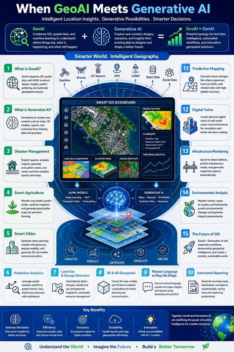
What happens when GeoAI meets Generative AI?
LinkedIn : linkedin.com/posts/hamas-ahm…
#México #SomosMéxico #Gis #remotesensing #GeoAi #Spatialanalysis #TEM11J #GeorgeGalloway #azlan #GisSpacialist
23
🚨 Only 4 days left to submit your abstract for the 2026 GPN MAC Convention!
⏳ Deadline is approaching fast—submit today!
#GIS #Geospatial #Mapping #SpatialAnalysis #GISCommunity
gpnmac26-urisa.hub.arcgis.co…

14

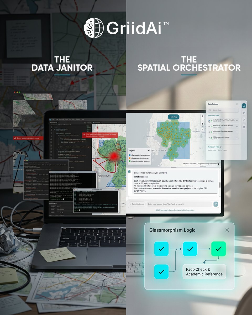
Your value is in your ability to validate the science, not write the syntax.
#GISCareers #SpatialAnalysis #DataEngineering #FutureOfWork #GriidAi
3

Higher resolution is not always better in geospatial work.
It gives more detail, but also more noise, cost, storage, and processing pain.
Sometimes 10m imagery is enough.
Sometimes you need 30cm.
Sometimes the answer depends more on the question than the pixels.
The real skill is matching resolution to the decision.
#RemoteSensing #GeoAI #SpatialAnalysis #Geospatial
7

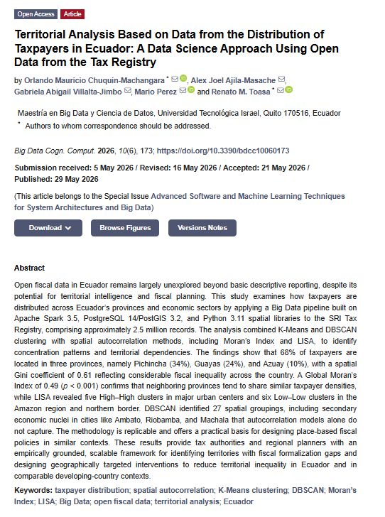
🔥 Call for Reading #OpenData #SpatialAnalysis #SmartGovernance
📖 Territorial Analysis Based on Data from the Distribution of Taxpayers in Ecuador: A Data Science Approach Using Open Data from the Tax Registry
📚full text:
brnw.ch/21x3bQ3

1
31

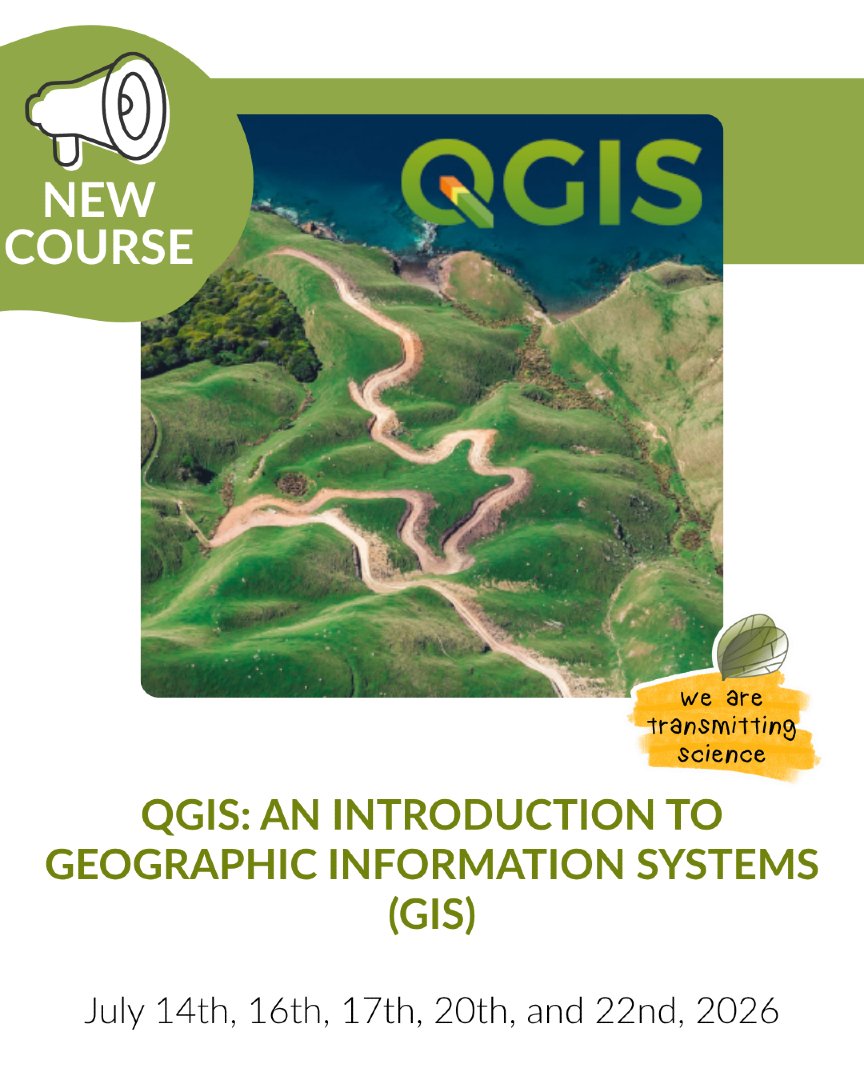
🚨 NEW COURSE
QGIS: An Introduction to Geographic Information Systems (GIS)
📅 July 14th, 16th, 17th, 20th, and 22nd, 2026
🌐 Online format
Info: transmittingscience.com/cour…
#QGIS #GIS #SpatialAnalysis
1
1
7
388

Jun 1
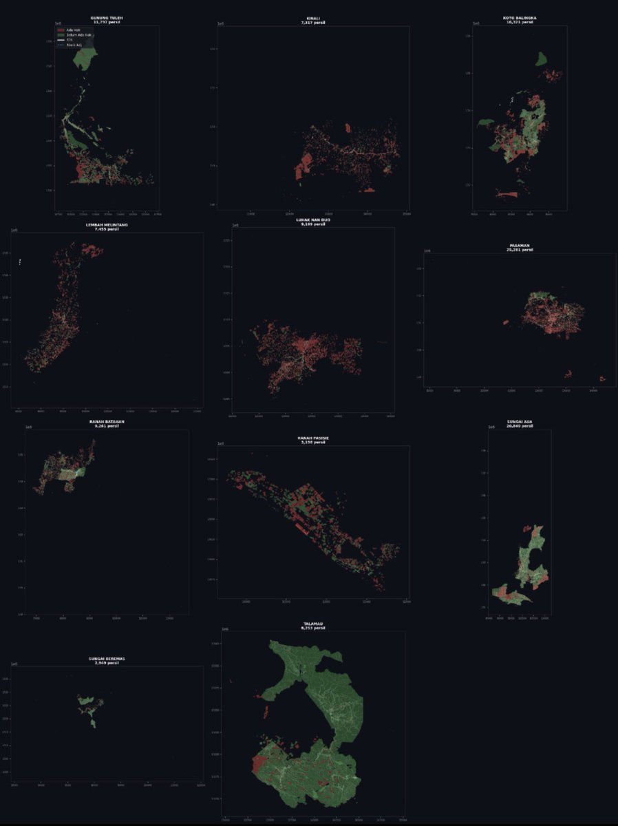
Alhamdulillah, akhirnya AI agent yang lagi gue kembangkan bisa memproses ratusan ribu file shapefile satu kabupaten dalam hitungan menit.
Contohnya kemarin — semua data GIS (hak lahan, hutan, konsesi, dll) langsung diproses, dianalisis, dan jadi visualisasi peta per kecamatan seperti ini.
Hasilnya masih sederhana, tapi cukup jelas buat melihat overlay antara data vektor dan tutupan lahannya. Warna merah artinya ada hak, hijau dalam area hak/hutan, dll.
Proses yang biasanya butuh berhari-hari (bahkan berminggu-minggu) kalau manual, sekarang bisa jauh lebih cepat.
Semoga ini bisa membantu teman-teman yang sering kerja dengan data spasial skala besar — entah untuk analisis deforestasi, tata ruang, verifikasi lahan, atau monitoring lingkungan.
Masih banyak yang perlu diperbaiki sih, tapi senang banget akhirnya ada progress kecil ini.
#GISIndonesia #Shapefile #SpatialAnalysis #AIGIS
14
18
152
5,475

May 22
The spatial distribution of 7,000 secondary schools across Uganda's districts.
Most schools are clustered around Central (Kampala, Mukono, Luwero, Buikwe) and the Western region, while the Northern Region, especially the Karamoja region, still lags behind.
Workflow:
1. Joined a dataset of over 7,000 secondary schools to a Uganda district shapefile in QGIS
2. Then used the group stats plugin to count the number of schools per district.
3. Lastly, I used a choropleth map to visualize the distribution based on school count
#QGIS #GIS #Uganda #DataVisualization #Education #SpatialAnalysis #Africa

1
4
92

May 22
Exploring Kenya’s population distribution.
This population density map, created from the Global Human Settlement Population Grid (GHS-POP) dataset, visualizes population counts per 100-meter grid cell across Kenya.
#GIS #Geospatial #QGIS #DataVisualization #SpatialAnalysis #Kenya

2
4
109
How to Publish Google Earth Engine Apps | Complete GEE Web App Tutorial. Tutorial link: youtu.be/B0JdQVgRVVU
#WebGIS
#GIS
#remotesensing
#geospatial
#EarthObservation
#GeoAI
#SpatialAnalysis
#appdevelopment
#mapping
1
1
3
205
May 15
Using the Esri 10 m Land Cover dataset and DEM data from USGS EarthExplorer, I processed and analyzed the data and area statistics in QGIS, with tables and charts prepared in Microsoft Excel.
#GIS#RemoteSensing. #Geospatial #LandCover #DataAnalysis #Cartography #SpatialAnalysis

3
11
45
1,443

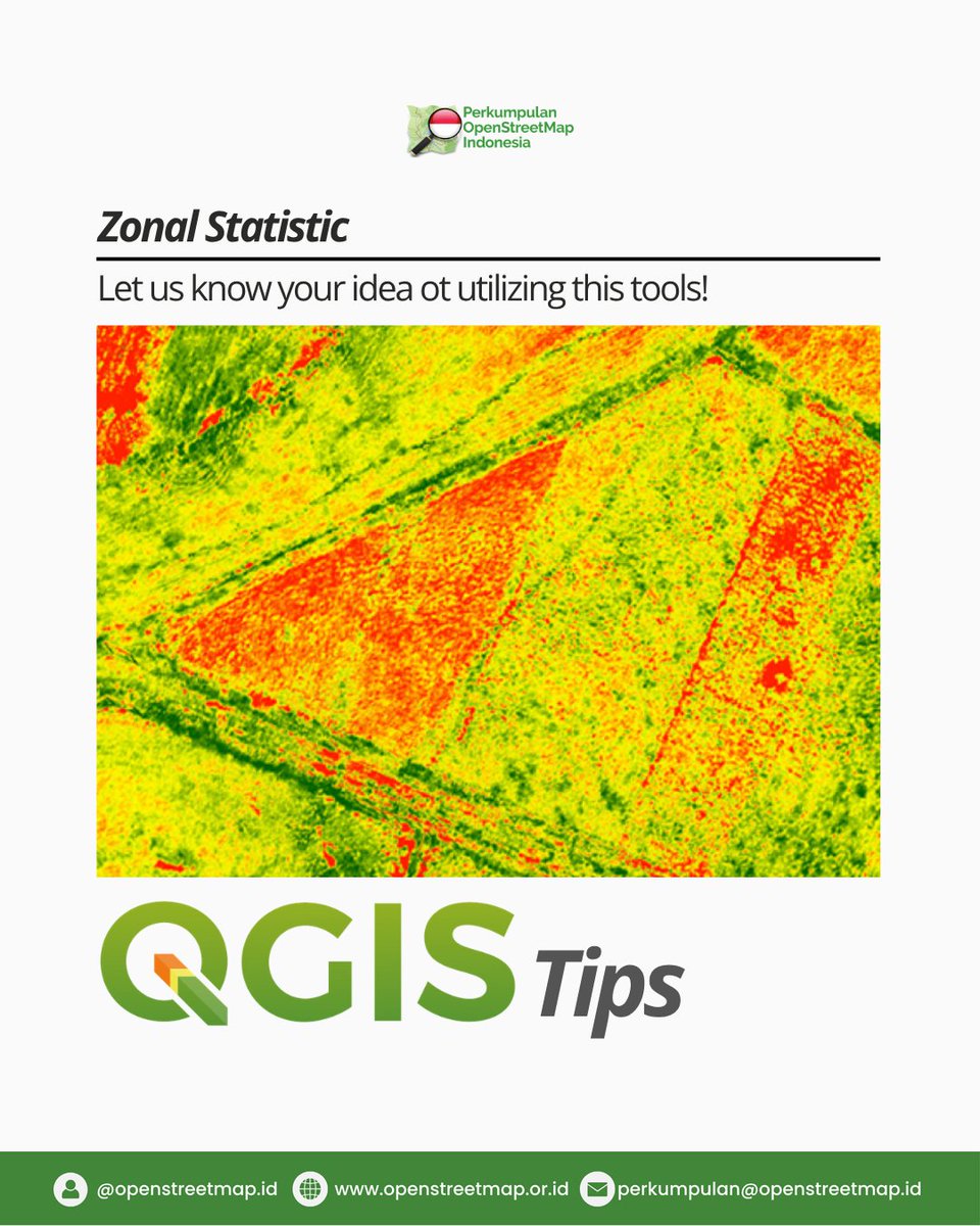
Have you ever used Zonal Statistics in QGIS? 🗺️
This technique helps transform raster data like DEM, slope, NDVI, rainfall, or heatmaps into meaningful statistical insights. 📊
What kind of raster data would you like to analyze?
#GIS
#QGIS
#SpatialAnalysis
#ZonalStatistics
1
10
43
1,299
May 15
This map presents a land cover analysis of Nairobi in which I used the Esri 10 m Global Land Cover dataset (2024) and DEM elevation data from USGS Earth Explorer.
#QGIS #GIS #RemoteSensing #Landcover #EnvironmentalAnalysis #Landsat #ESRI #SpatialAnalysis

1
3
17
646

Central England becomes a visible transition zone. 🌿
You can literally watch the UK shift from cold upland hydrology to warmer southern systems through color gradients alone.
No labels needed.
#SpatialAnalysis #ClimateMapping #Maps
1
2
19
Agricultural Land Suitability Detection Model Using Google Earth Engine | Suitability Analysis Tutorial. The tutorial link: youtu.be/tN0z7muFffE
Registration link: studyhacksgeospatial.com/pro…
#agriculture
#googleearthengine
#GIS
#remotesensing
#EarthObservation
#SpatialAnalysis
3
20
882
How to Create Time Series Charts Using Google Earth Engine & ArcGIS Pro | Complete Tutorial Link: youtu.be/ylWbiVxO8Pw
Registration link: studyhacksgeospatial.com/pro…
#googleearthengine
#GIS
#remotesensing
#cartography
#geospatial
#SpatialAnalysis
#EarthObservation
1
20
1,006
How to Create a Map Layout Using Google Earth Engine & ArcGIS Pro | Complete GIS Tutorial. Tutorial link: youtu.be/ayBujqa9jq8
Registration link: studyhacksgeospatial.com/pro…
#ArcGISPro
#googleearthengine
#GIS
#remotesensing
#cartography
#MapLayout
#geospatial
#SpatialAnalysis
3
12
849