
🇫🇷 Excited to be joining the official Victorian Government delegation at #VivaTech2026 in Paris 17–20 June.
Looking forward to showcasing how SKAND helps organisations unlock value from spatial data.
#Geospatial #SpatialData #DigitalTransformation #GlobalVictoria

7

Precision nutrient management requires precision data. How do we balance crop nutrition with environmental safety in drylands? New high-resolution phosphorus mapping across China’s arid zones provides solutions: ow.ly/bxcj50Z7ims
#SpatialData #SoilMapping

79

Precision nutrient management requires precision data. How do we balance crop nutrition with environmental safety in drylands? New high-resolution phosphorus mapping across China’s arid zones provides solutions: ow.ly/wwWW50Z7ii1
#SpatialData #SoilMapping

4
7
348

Jun 11
His decision to join reflects his commitment to advancing geospatial innovation and data-driven decision-making.
We are delighted to welcome Onyedikachi to our vibrant community of professionals and innovators.
#ProfessionalMembership #GIScience #GeoAI #SpatialData
1
17

Spatial data is no longer a technical add-on. The new @Stantec appointment puts GIS and digital asset intelligence closer to client decisions.
#SpatialData #GeospatialAdvisory #Stantec #DigitalTwins #InfrastructurePlanning #GIS
insidewater.com.au/geospatia…
9

Jun 9
🚶🚗 What if your daily movement could earn rewards?
Commute, Travel, Meet friends.
Go wherever life takes you.
Every movement creates data.
Every place you visit adds value.
TINA transforms real-world movement and place activity into valuable spatial data for the Geo-DePIN ecosystem.
🎁 Move
📍 Contribute
💰 Earn
Curious how it works?🎥
Watch our latest guide and discover how TINA rewards everyday movement 👇
youtube.com/watch?v=DUG7FSkD…
🚶🚗 일상의 이동이 보상이 된다면?
출퇴근, 여행, 친구와의 약속
우리가 매일 하는 이동과 방문이
가치 있는 데이터가 될 수 있습니다.
TINA는 실제 이동과 장소 활동을
Geo-DePIN 생태계의 공간 데이터로 전환하고,
참여자에게 리워드를 제공합니다.
🎁 이동하고
📍 데이터에 기여하고
💰 보상받고
어떻게 가능한지 궁금하신가요?
🎥 최신 가이드 영상에서 TINA의 주행 리워드 기능을 확인해보세요 👇
youtube.com/watch?v=DUG7FSkD…
#TINA #GeoDePIN #DePIN #MoveToEarn #DriveToEarn #Web3 #Solana #SpatialData
1
10
731

Jun 8
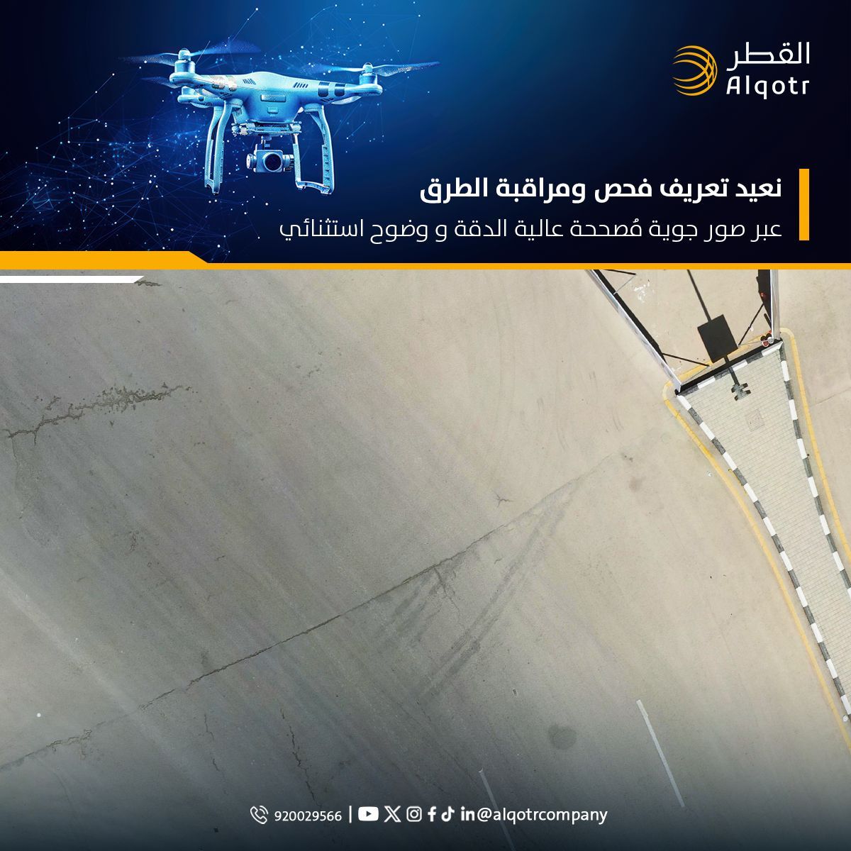
البيانات الدقيقة ليست مجرد معلومات، بل هي أساس التخطيط الذكي والتنمية المستدامة.
ومن خلال تقنيات التصوير الجوي المتقدمة، تقدم شركة القطر حلولاً جيومكانية متكاملة توفر رؤية دقيقة وحديثة للمدن والمشروعات، عبر إنتاج بيانات مكانية عالية الاعتمادية تعكس الواقع كما هو، وتدعم عمليات التحليل والتخطيط وصناعة القرار بكفاءة استثنائية.
وتُمكّن هذه الحلول الجهات الحكومية والخاصة من مراقبة التغيرات المكانية، وتعزيز جودة المعلومات الجغرافية، ورفع كفاءة إدارة المشروعات والأصول، بما يسهم في بناء مدن أكثر ذكاءً واستدامة، واتخاذ قرارات قائمة على بيانات دقيقة ورؤية مستقبلية.
Accurate data is not merely information; it is the foundation of smart planning and sustainable development.
Through advanced aerial imaging technologies, Alqotr Company delivers integrated geospatial solutions that provide an accurate and up-to-date view of cities and projects by producing highly reliable spatial data that reflects reality as it is, while supporting analysis, planning, and decision-making processes with exceptional efficiency.
These solutions enable both public and private sector entities to monitor spatial changes, enhance the quality of geographic information, and improve the efficiency of project and asset management. This contributes to building smarter and more sustainable cities while supporting decisions based on accurate data and a forward-looking vision.
#Alqotr_Company #Geospatial #GIS #AerialSurvey #Photogrammetry #RemoteSensing #SmartCities #SpatialData #UrbanPlanning #DigitalTransformation
112
Jun 8
📢 TINA × INAVI SYSYEMS
TINA has signed a POI data supply agreement with INAVI SYSYEMS.
The POI data generated by the TINA network is now moving beyond collection and into real-world industry use.
Together, TINA and INAVI will also collaborate on data verification and quality assurance to build a more reliable spatial data infrastructure.
🌍 Real Users
📍 Real Data
⚡ Real Utility
This is what Geo-DePIN looks like in the real world.
TINA가 아이나비시스템즈와 POI(Point of Interest) 데이터 공급 계약을 체결했습니다.
이번 계약을 통해 TINA 서비스에서 구축된
실제 공간 데이터(POI)가 아이나비에 공급될 예정입니다.
양사는 데이터 검수 및 품질 검증 과정에서도 협업을 진행하며,
보다 정확하고 신뢰도 높은 공간 데이터 구축 체계를 함께 고도화해 나갈 예정입니다.
이는 커뮤니티 기반으로 생성된 공간 데이터가
실제 산업에서 활용되는 Geo-DePIN 생태계 확장의 의미 있는 사례입니다.
Real Users → Real Data → Real Utility
TINA는 앞으로도
실제 활용 가능한 글로벌 공간 데이터 생태계 구축을 지속적으로 확대해 나가겠습니다 🌍
#TINA #INAVY #THINKWARE #INAVISYSTEMS #DataSupplyAgreement #StrategicPartnership #EnterprisePartnership #Commercialization #EnterpriseAdoption #RealWorldUtility #GeoDePIN #DePIN #SpatialData #LocationData #DataInfrastructure #POI #Web3 #Partnership

1
58
112
7,940

(Open Access) GIS: A Computing Perspective: freecomputerbooks.com/GIS-A-…
Look for "Read and Download Links" section to download. Follow me if you like this
#GIS #GeographicInformation #GeographicData #GeographicAnalysis #SpatialData #SpatialAnalysis #GenAI #GenerativeAI #LLMs #Gemini

1
56

Check out this blog about one Marine's experience leveraging ArcGIS for SharePoint to create a digital Combat Operations Center. This is an excellent use case for how to digitally solve an analog workflow. #ArcGIS #SharePoint #DataManagement #SpatialData"
ow.ly/EJbA50Z5MYh
31

Urban Growth Monitoring using Remote Sensing || Urban Expansion Mapping in Google Earth Engine. Full tutorial link: youtu.be/kUHOLFnpMro?si=JrB3…
Registration link: studyhacksgeospatial.com/pro…
#googleearthengine #GIS #Geospatial #GeospatialAnalysis #SpatialData #EarthObservation
1
4
20
810

🌍 This World Environment Day, let's use the power of geospatial intelligence to create a smarter, greener future.
#WorldEnvironmentDay #GeospatialServices #GIS #Sustainability #EnvironmentalMonitoring #SpatialData #GreenTechnology #ClimateAction #ApexSolutionsLtd
3
🚀 Start Your Geospatial Journey Today! Learn Google Earth Engine in ArcGIS Pro & QGIS — No Coding Required. Transform satellite data into powerful insights with hands-on training.
#googleearthengine #remotesensing #GIS #Geospatial #GeospatialAnalysis #SpatialData

1
2
177

echo3D is proud to sponsor the upcoming Industrial Digital Reality Summit!
Join us in Houston, XT between June 22-24 by using the code IEWEEK200OFF for $200 off a Conference pass or a FREE Expo pass.
Registration link: eu1.hubs.ly/H0sqqjL0
#IDRSummit #echo3d #digitaltransformation #digitalassetmanagement #3DDAM #spatialdata #3D

30

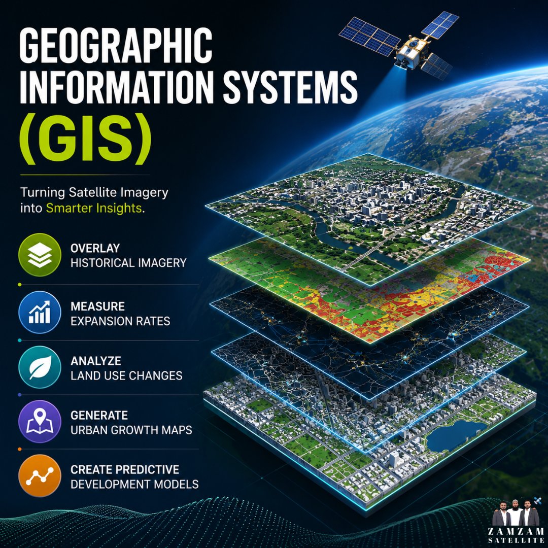
Transform satellite imagery into actionable intelligence with Geographic Information Systems (GIS).
At Zam Zam Satellite, we help organizations visualize change, analyze land use, monitor growth, and make smarter planning decisions through advanced geospatial solutions.
zamzamsatellite.com/
#GIS #SatelliteImagery #RemoteSensing #Geospatial #UrbanPlanning #SmartCities #EarthObservation #SpatialData #AI #ZamZamSatellite
1
50

THE CITY YOU SEE WAS PLANNED 🏙️
Every road, neighborhood, commercial center, and public facility begins with a plan.
Smart cities don't happen by accident.
🌐 Learn more: cliffordgeoconsult.com
#GIS #UrbanPlanning #LandUsePlanning #SmartCities #SpatialData #CliffordGeoConsult

1
4

Jun 3
LiDAR hardware is more accessible than it’s ever been.
So why are fast-paced operations still forced to make decisions from LiDAR data that's hours — or days — old?
Here’s our perspective 👇
row64.com/blog/lidar-data-is…
#LiDAR #DetectionGap #spatialdata #operationalintelligence

1
1
13

Jun 3
[WHAT IS A SECTIONAL TITLE?]
A Sectional Title is a form of property ownership that allows you to own a specific section or unit of a building or development- such as a flat, townhouse, or office unit - while sharing ownership of the common property with other owners.
Common property may include:
✔️ Driveways
✔️ Gardens
✔️ Parking areas
✔️ Recreational facilities such as a swimming pool or braai-area
Each section is accurately measured and depicted on a Sectional Title Plan prepared by a professional land surveyor and approved by the relevant authorities.
Understanding sectional titles is important when buying, selling, developing, or managing property, as it clearly defines ownership boundaries and rights.
For more on Sectional Titles contact us at the details below:
📧 admin@wmpb.co.za
☎️ (031) 140 0446
📱 WhatsApp: 073 783 3171
🌐 wmpb.co.za
#LandSurveying #SectionalTitle #PropertyOwnership #PropertyDevelopment #Surveying #WMPB #SpatialData #SouthAfricaProperty #LandSurveyor

4
1
68

Veris Limited wins new digital contracts as ASX:VRS pushes deeper into spatial data services business-news-today.com/veri… $VRS #VerisLimited #Geospatial #SpatialData #DigitalInfrastructure #InfrastructureTech #ASX #Octave #MicrocapStocks #VRS #Veris
1
22

May 28
Explore the new IMGS website.
Discover how IMGS helps organisations connect, migrate, manage and act on their data through powerful geospatial solutions and spatial data expertise.
🌐 zurl.co/06Y2T
#GIS #Geospatial #FME #SpatialData @Safe Software @HexagonSIG

29