
May 16

1
50

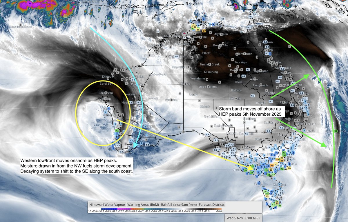
Australia’s wettest week of spring is now behind us — and the next surge is already forming.
The 29 Oct – 5 Nov High-Energy Period delivered 250 mm peaks in northern NSW and widespread 50 mm falls through QLD, NT and WA’s far northwest.
Moisture is now locked in nationwide, setting the stage for the most active late-spring trough cycle of the year.
At the same time, early modelling trends are beginning to signal the first tropical feature of the 2025–26 wet season, with development potential emerging from early December across the northwest and adjacent Indian Ocean basin.
Model volatility remains high at this range, and early cyclone signals are often over-simulated by both deterministic and ensemble outputs.
Members are reminded to beware of cyclone commentary circulating on social media, as these are typically misunderstood and misleading.
For verified cyclone timelines and probability zones, refer to the December Long-Range Forecast attached within today’s update, which outlines expected tropical feature development dates, track summary and timelines.
Read our full breakdown of rainfall, temperature and storm risks for each district across the country.
🔗ozindustriesforecasting.com/…
#AustralianWeather #SpringRainfall #HighEnergyPeriod #WeatherForecast #LongRangeOutlook #StormSeason #ClimateDrivers #OIF
#KnowTheFuture™
489

17 May 2025
Making good use of the #SpringRainfall to clean the balcony—nature lending a hand with the chores. #RetiringInJapan 🇯🇵☔🧹
1
100

24 Sep 2022
Ngaruroro river came into flood quickly after recent heavy rain in Hawke’s Bay. #enoughisenough #springrainfall #atimetoplant
2

7 Apr 2022
Living in the St. Louis metropolitan area means that rain could come without warning - literally!
Don't wait until the spring showers this year; get your home waterproofed beforehand so you can prepare for Midwest storms.☔
#PermaJackProvides #StLouisShowers #SpringRainFall


31 Aug 2020
VIDEO FORECAST FOR TODAY AND TUESDAY
Strong COL ushers in well-defined #SpringRainfall into the central interior Tues and Wed.
Expect #Windy and #Rainy conditions including possible flash floods in places where the rain will be intense.
@_ArriveAlive @ReenvalSA @ASKMeteo
2
1
11
