- Tweets 176
- Following 519
- Followers 26
- Likes 60


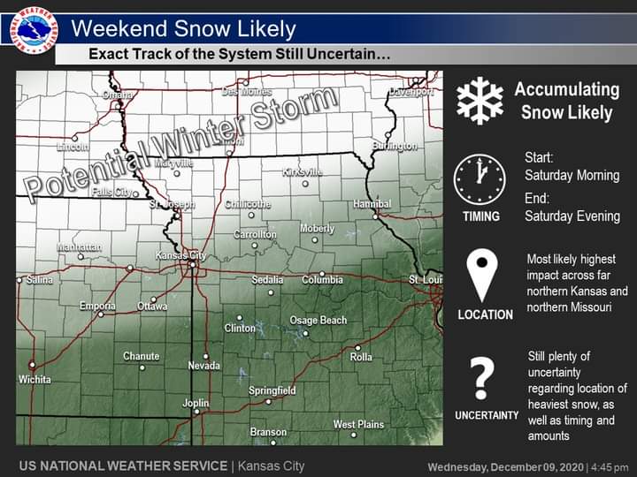


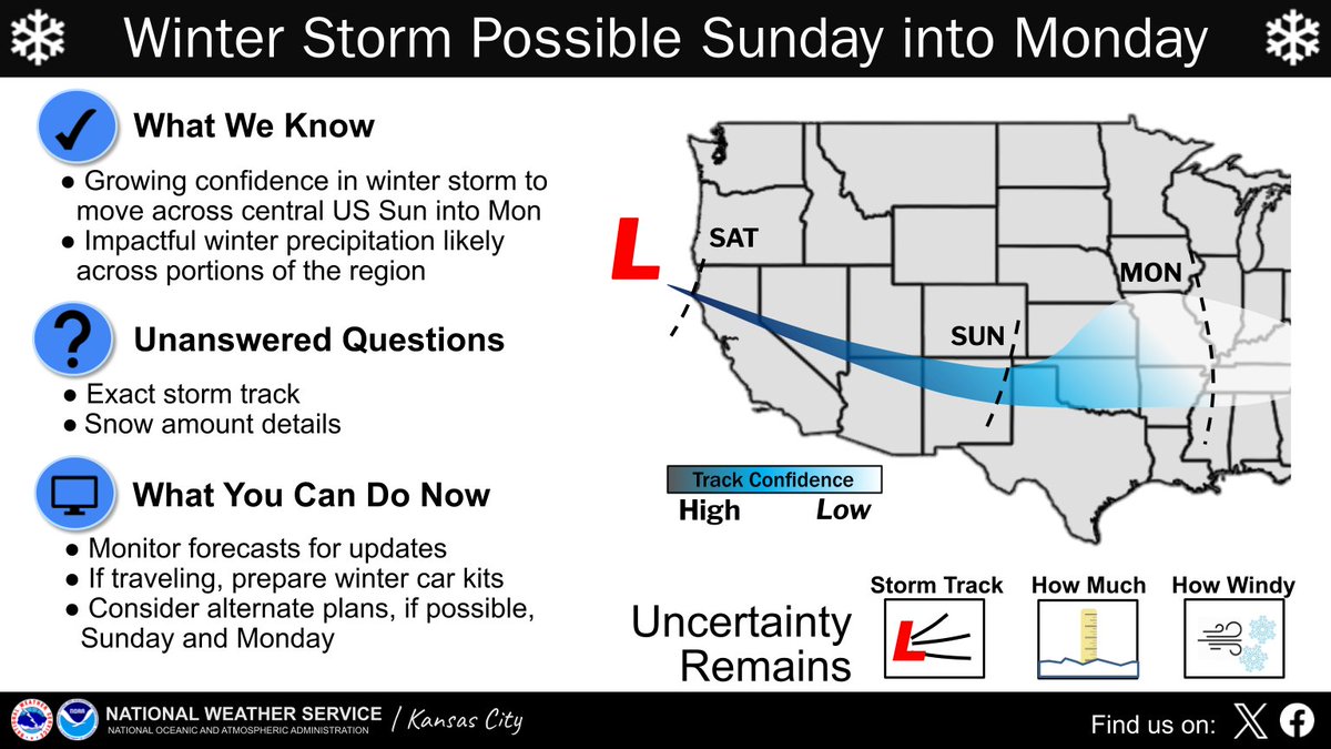
ALT Aside from post text, graphic shows a broad path for the expected storm system late this weekend. Highlights some of the uncertainty that remains as well as what we currently known. Also points out a few things you can do, including staying up to date to forecasts, prepare winter travel kits if traveling, and consider alternate plans if possible.

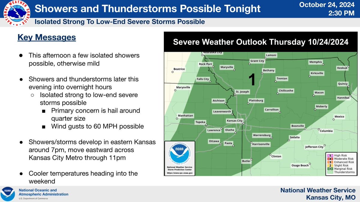
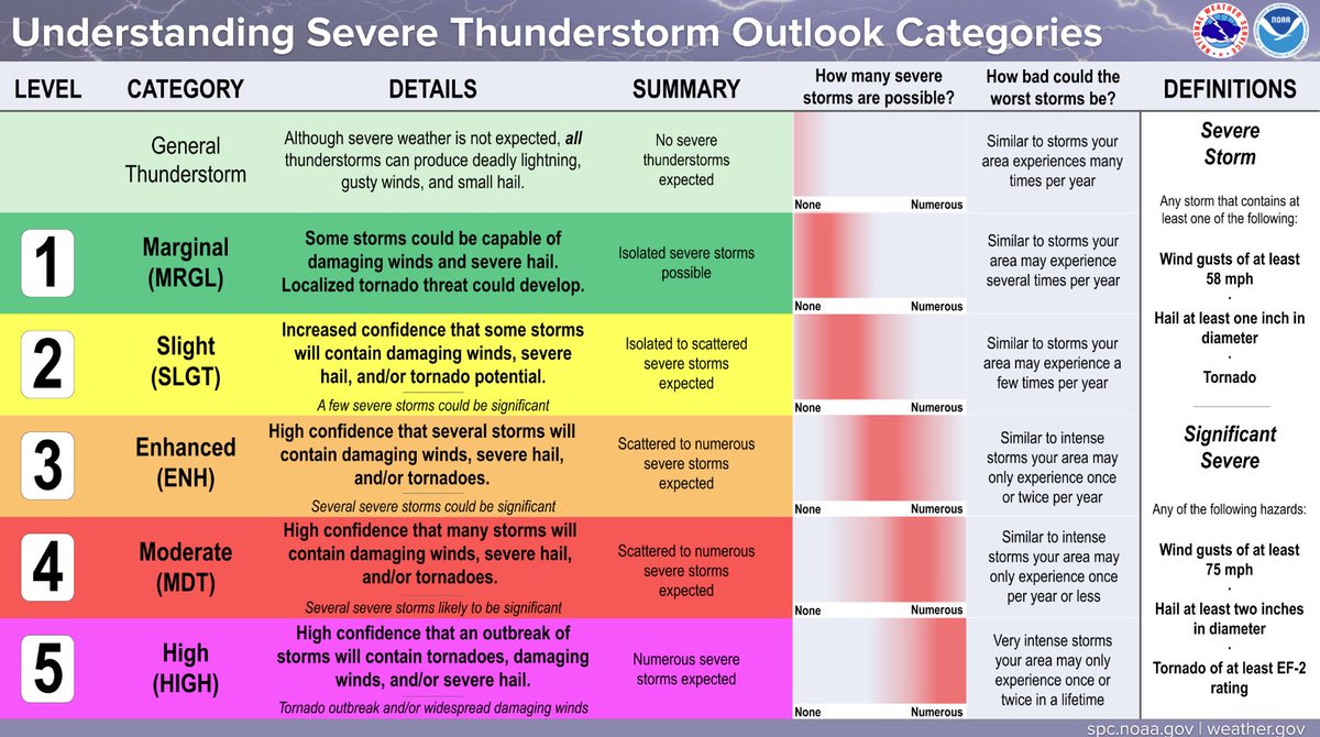
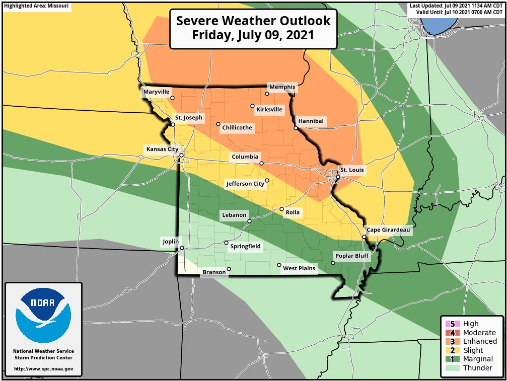
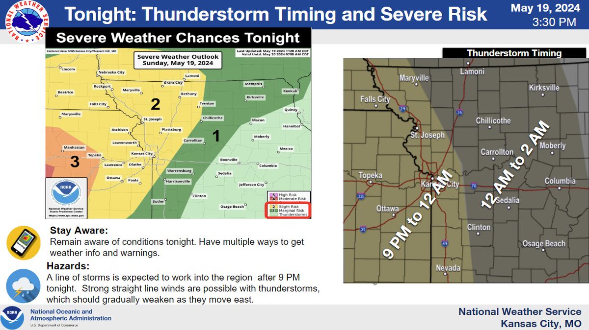
ALT A few isolated showers are possible this afternoon but otherwise mild. More organized showers/storm are forecast this evening into Friday. A few isolated low-end severe storms possible with hail to around quarter size and wind gusts around 60 MPH. On the right hand side is the Severe Convective Outlook for Day 1 from the SPC, issued at 06z. A large portion of the area is in a level 1 marginal risk.
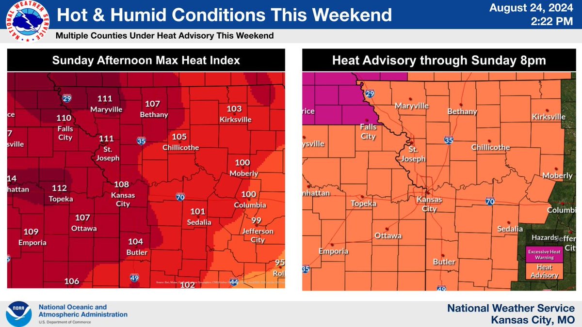
ALT 2 images of eastern KS and Missouri. The first shows heat index values ranging from 103-111 across the area for Sunday. It also shows a heat advisory for the entire area Sunday with an excessive heat warning for southeast Nebraska and southwest Iowa.
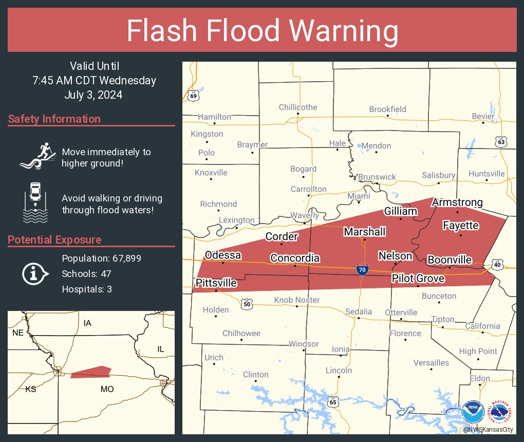
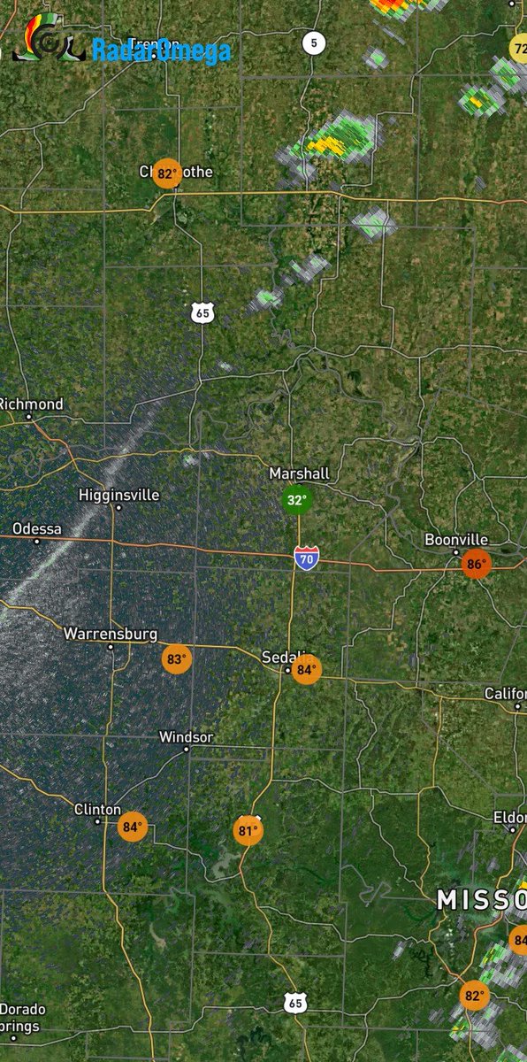
ALT This graphic displays a flash flood warning plotted on a map. The warning is in effect until 7:45 AM CDT. The warning includes Marshall MO, Boonville MO and Odessa MO. This warning is for Northern Cooper County in central Missouri, Howard County in central Missouri, Northern Pettis County in central Missouri, Saline County in central Missouri, Southeastern Chariton County in north central Missouri, Northern Johnson County in west central Missouri and Lafayette County in west central Missouri. Avoid walking or driving through flood waters! Move immediately to higher ground! There are 67,899 people in the warning along with 47 schools and 3 hospitals.
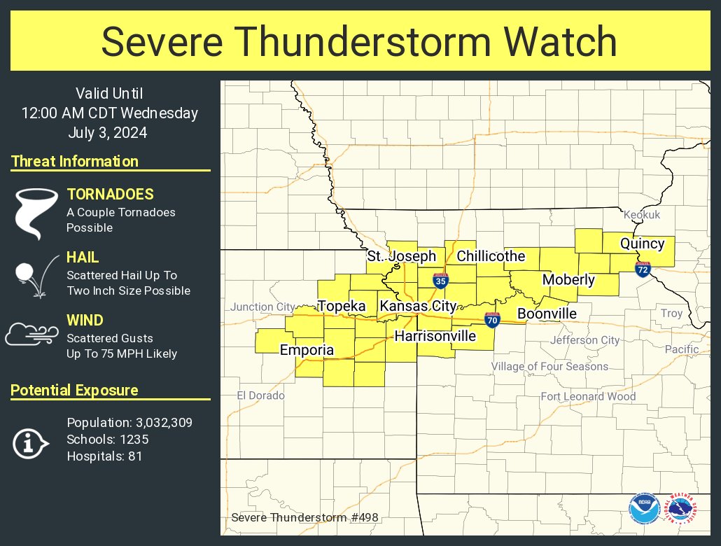
ALT This graphic displays Severe Thunderstorm watch number 498 plotted on a map. The watch is in effect until 12:00 AM CDT. The watch includes parts of Illinois, Kansas and Missouri. The threats associated with this watch are a couple tornadoes possible, scattered hail up to two inch size possible and scattered gusts up to 75 mph likely. There are 3,032,309 people in the watch along with 1235 schools and 81 hospitals.
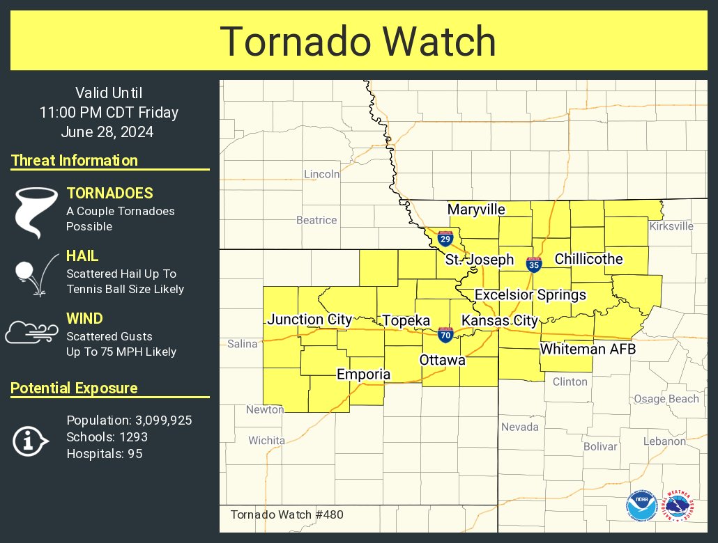
ALT This graphic displays Tornado Watch watch number 480 plotted on a map. The watch is in effect until 11:00 PM CDT. The watch includes parts of Kansas and Missouri. The threats associated with this watch are a couple tornadoes possible, scattered hail up to tennis ball size likely and scattered gusts up to 75 mph likely. There are 3,099,925 people in the watch along with 1293 schools and 95 hospitals.

ALT This graphic displays a severe thunderstorm warning plotted on a map. The warning is in effect until 2:15 AM CDT. The warning includes Marshall MO, Macon MO and Higginsville MO. This warning is for Chariton County in north central Missouri, Northwestern Randolph County in north central Missouri, Southeastern Linn County in north central Missouri, Carroll County in north central Missouri, Saline County in central Missouri, Macon County in north central Missouri and Eastern Lafayette County in west central Missouri. The threats associated with this warning are wind gusts up to 60 MPH and nickel sized hail. There are 57,747 people in the warning along with 62 schools and 3 hospitals.


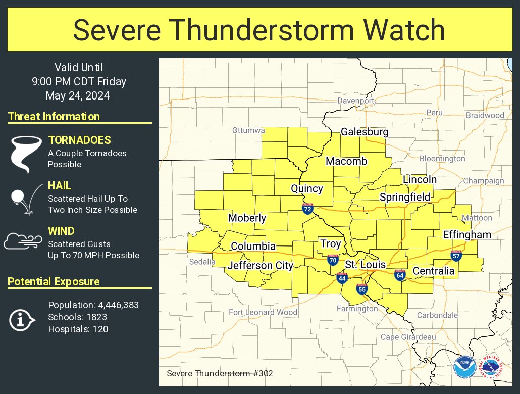
ALT This graphic displays Severe Thunderstorm watch number 302 plotted on a map. The watch is in effect until 9:00 PM CDT. The watch includes parts of Illinois, Iowa and Missouri. The threats associated with this watch are a couple tornadoes possible, scattered hail up to two inch size possible and scattered gusts up to 70 mph possible. There are 4,446,383 people in the watch along with 1823 schools and 120 hospitals.


ALT This graphic displays Tornado Watch watch number 278 plotted on a map. The watch is in effect until 10:00 PM CDT. The watch includes parts of Arkansas, Kansas, Missouri and Oklahoma. The threats associated with this watch are a few tornadoes likely, scattered hail up to softball size likely and scattered gusts up to 75 mph likely. There are 5,509,393 people in the watch along with 2165 schools and 167 hospitals.

ALT Waves of thunderstorms are possible, mainly north of I-70 early Tuesday morning. Large hail(up to 2” in diameter) and damaging winds (winds up to 65 mph) are the main threats. New storm development possible after 2 PM Tuesday afternoon. Expected afternoon development of storms will be from west central MO to northeast MO, with the line progressing southeast. When storms are isolated-scattered in nature: All hazards including strong tornadoes are possible. Once storms develop into a line: Wind gusts in excess of 70 MPH, Hail to the size of half dollars, and brief tornadoes are all possible.


ALT This graphic displays Severe Thunderstorm watch number 166 plotted on a map. The watch is in effect until 12:00 AM CDT. The watch includes parts of Kansas and Missouri. The threats associated with this watch are a couple tornadoes possible, scattered hail up to tennis ball size likely and scattered gusts up to 75 mph likely. There are 2,510,085 people in the watch along with 990 schools and 69 hospitals.

ALT This graphic displays Tornado Watch watch number 149 plotted on a map. The watch is in effect until 12:00 AM CDT. The watch includes parts of Kansas and Missouri. The threats associated with this watch are a few tornadoes likely, scattered hail up to two inch size likely and widespread gusts up to 70 mph likely. There are 2,760,928 people in the watch along with 1111 schools and 84 hospitals.