Mama. Partner @MelwoodGlobal. Former Hill Comms Director, DHS & DOI spox. Proud @Wheaton alum. I live by my to-do lists. Opinions=my own.
Joined June 2010
- Tweets 4,979
- Following 2,269
- Followers 695
- Likes 10,559
1,018 Photos and videos


Pinned Tweet

23 Nov 2024
Hi @PeteButtigieg! My husband has informed me I cut you off this morning walking through @Reagan_Airport while toting my daughter on her ride along suitcase. 🤦♀️ I’m so sorry (and sad I didn’t say hi!)🫠ILYSM ❤️ - a very tired mama
8
36
955
26,167
Mandi DeGroff Munger retweeted

Jun 8
Honored to earn the endorsement of @seiu_ma, representing 120,000 workers across Massachusetts.
This is a game-changing moment for our people-powered campaign. I'm proud to have SEIU members standing with us, and I'm ready to keep fighting alongside working people in Congress.

1
9
29
1,376
Mandi DeGroff Munger retweeted

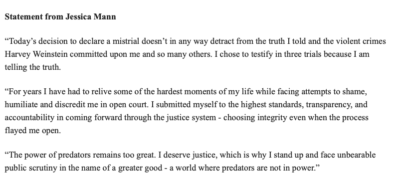
In a statement, Jessica Mann says she subjected herself to “unbearable public scrutiny” three times because she is telling the truth and deserves justice.

3
9
1,206
Mandi DeGroff Munger retweeted

May 15
🗞️Statement attributed to Harvey Weinstein accuser Jessica Mann, through the nonprofit group Survivors Say
May 15

🚨🗞️🚨The latest in Harvey Weinstein's New York legal saga -- a hung jury and a mistrial
Full story from @Laurynnboo 👇
foxnews.com/entertainment/ha…
2
3
20
3,942

Harvey Weinstein Rape Accuser Jessica Mann Breaks Silence After Mistrial Is Declared people.com/weinstein-accuser…
4
3
9
14,812
Mandi DeGroff Munger retweeted

May 15
Statement from survivor Jessica Mann on the judge's decision today to declare a mistrial in the case against Harvey Weinstein.
Media with additional questions can reach out to us at SurvivorsSay.org or directly via amanda@survivorssay.org or david@survivorssay.org.

2
3
105
Mandi DeGroff Munger retweeted
Apr 24
Excited for this important conversation on immigration. Tune in on IG on May 1 at 12 PM ET
Apr 20

📢 Tram Nguyen, Massachusetts State Representative running to represent Massachusetts’ 6th Congressional District

3
1
2
332
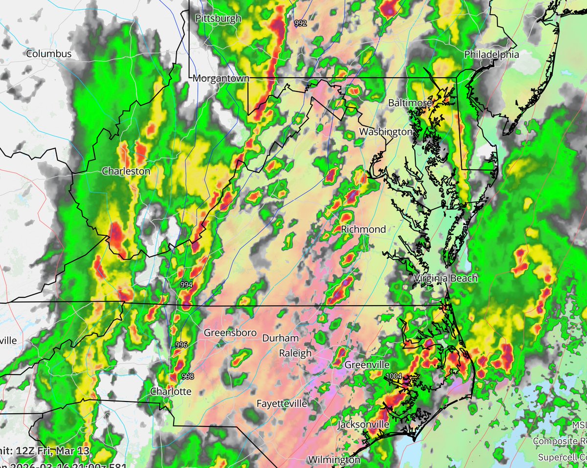
Mar 13
Nothing like the 80 degrees to snow to potential tornado weather whiplash to keep us guessing what jacket we need each day
Mar 13

Mid-Atlantic gang – the potential exists for a regional tornado episode on Monday, March 16. This reminds me a bit of February 23-24, 2016. Long-time residents will recognize the day.
Now is the time to begin reviewing your severe weather plan... actually. We get 1-2 "tornado days" a year. We anticipate Monday will be one of them. (@MatthewCappucci spends a lot of time in the Midwest and on the Plains; the environment Monday will be rather similar to what he sees out west.)
We're still 4 days out from the event, but the "synoptic," or broad-scale picture, is somewhat concerning. We'll have a potent upper-air disturbance taking on a "\", or backslash shape, akin to a soccer player kicking a ball. That follow-through, or "negative tilt," gives the system more kick.
It will be just warm and humid enough for us to build some thunderstorm fuel, ESPECIALLY if the front slows down. Some of our high-resolution computer models are depicting "prefrontal" storms, or lone, discrete supercells popping ahead of an incoming squall line.
With robust shear, or changing winds with height, and a jet stream screaming overhead, these storms will rotate. IF any storms form ahead of the main line, they'll become spinning supercells with hail/tornado potential.
Then a fierce squall line will come through with damaging gusts and a few embedded tornadoes.
A lot can change, but for now, we'd like to start raising awareness of a potentially significant severe weather episode. We'll have more in the days ahead.
81
Feb 2
Phil. You really did not read the room this year!
Feb 2

Groundhog Day 2026: Punxsutawney Phil is said to have seen his shadow, forecasting 6 more weeks of winter.
1
51
24 Sep 2025
Thrilled to announce that @MelwoodGlobal is now an approved vendor under Massachusetts State Contract PRF86!
This five-year contract with the state allows us to expand our partnerships with state and municipal offices in MA on creative services, public relations & marketing.
If you're looking for communications, web design, advertising and marketing support, we're eager to work with you and support your efforts. Send me a note and I'd love to find time to connect.
1
1
86
23 Sep 2025
Thinking of updating your website or launching a new site? I would love to talk.
Our Melwood Global team recently worked with the Massachusetts Disabled Persons Protection Commission to design a modern and accessible website that serves as a resource to help in recognizing and reporting signs of abuse and neglect against people living with disabilities.
The website is focused on ease of use and giving users easily digestible information on the prevalence of abuse and crimes against adults with disabilities and resources to help people recognize signs of abuse and report potential crimes.
Our team developed this entirely new website alongside the DPPC team, with a focus on making the new site modern and accessible.
Some of the features on the new website include:
- More readability options for members of the public seeking information and resources
- Users can now adjust text sizes, fonts, contrast strength, and background colors
- You can now also shift the entire website to grayscale
We have been proud to partner with DPPC on these efforts and would love to talk to you about any design needs you are thinking about as we close out 2025.
51
Mandi DeGroff Munger retweeted

19 May 2025
Harvey Weinstein Accuser Jessica Mann Testifies in Court, Says He Was "Dr. Jekyll and Mr. Hyde" hollywoodreporter.com/news/g…
3
1
11
15,778
13 May 2025
Really proud of our @MelwoodGlobal team that has worked so hard to support DPPC on these projects.
12 May 2025
We are thrilled to work alongside the Disabled Persons Protection Committee to launch its new accessibility-focused website & develop 3 new training videos. Check them out!
Website: dppcmass.gov
Video Series: dppcmass.gov/?page_id=105

1
1
2
182
2 Apr 2025
Proud of @alex_psilakis on this well-deserved promotion. He's had some amazing wins for clients and works hard for all their missions. Way to go, Alex!
2 Apr 2025
Congratulations to Melwood's @alex_psilakis on his promotion to Senior Account Executive! Alex has accomplished so much over the last three years. We applaud his hard work, dedication and commitment to clients.
We are excited to see Alex take on this new role!

1
1
2
126
Mandi DeGroff Munger retweeted

1 Apr 2025
Thrilled to have another incredible colleague - welcome to the team @erinheeter!!
1 Apr 2025
We are thrilled to welcome @erinheeter to our Melwood Global team! Erin brings deep experience from the White House, Homeland Security & Senate. As Vice President, Erin will help lead our media relations, strategic comms & crisis comms work in DC & around the world. Welcome Erin!

2
2
138
1 Apr 2025
I am so excited to have Erin joining our team at @MelwoodGlobal! I'm lucky to have worked with @erinheeter at the Department of Homeland Security and have seen firsthand her depth of skills as a communicator, her determination and her fierce loyalty to the missions she supports.
We are building the strongest strategic communications team working across Washington, D.C., Boston and around the world. We are working at the center of some of the biggest, most complicated and important issues facing our nation.
Welcome, Erin!
1 Apr 2025
We are thrilled to welcome @erinheeter to our Melwood Global team! Erin brings deep experience from the White House, Homeland Security & Senate. As Vice President, Erin will help lead our media relations, strategic comms & crisis comms work in DC & around the world. Welcome Erin!
2
1
4
128
Mandi DeGroff Munger retweeted
1 Apr 2025
We are thrilled to welcome @erinheeter to our Melwood Global team! Erin brings deep experience from the White House, Homeland Security & Senate. As Vice President, Erin will help lead our media relations, strategic comms & crisis comms work in DC & around the world. Welcome Erin!
1
2
5
832