
Mapillary, a Meta company, is the street-level imagery platform that scales and automates mapping using collaboration, cameras, and computer vision.
Joined August 2013
- Tweets 4,705
- Following 489
- Followers 10,993
- Likes 4,738
1,686 Photos and videos


Pinned Tweet

19 Feb 2025
We're excited to announce that Mapillary now features @Esri satellite imagery as a map style, available on all of our platforms.
Unlock new geointelligence opportunities by visualizing your Mapillary captures against satellite imagery. Give it a try today!

4
16
45
4,435
Jun 12
Mapillary API Update : Radius Search 📍 🕛
We are excited to share that you can now instantly search for images near any geographic coordinate using latitude, longitude, and a radius, complete with smart filtering
Give it a try: mapillary.com/developer/api-…
#Mapillary #Developers
2
21
1,443
May 27
Faster, Smarter, Better: Mapillary Uploader 5.1.1 is here! 💻
We’ve optimized the upload process to save power users critical time. Plus, enjoy enhanced camera compatibility with mapillary_tools v0.14.6 and bug fixes.
#Mapillary #GIS #Geospatial
1
4
307
May 21
🌍 Mapillary Blog: Giving AI a Sense of Place with @zephrxyz 📍
Using @mapillary imagery @OvertureMaps data to cut POI position error by 67% and ground AI in a real sense of place.
Read here: blog.mapillary.com/update/20…
#SpatialAI #Mapillary #OvertureMaps
2
6
730
May 8
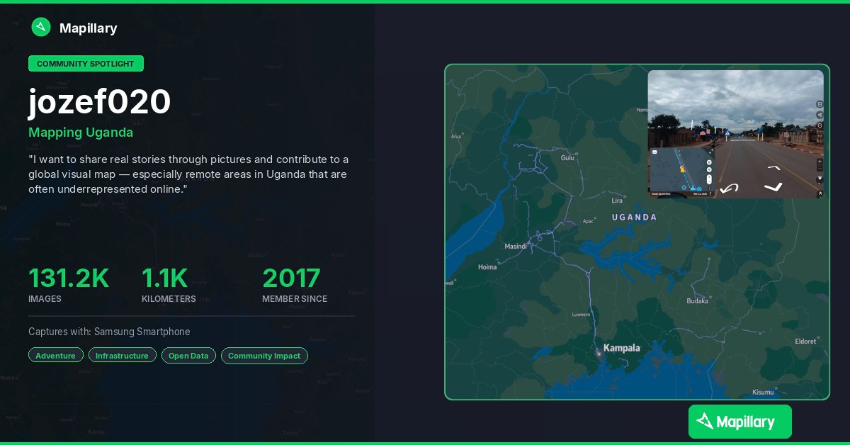
Community Spotlight: Mapping the unmapped in Uganda 🌍
Using the Mapillary app, Joseph is capturing vital street-level imagery, bringing remote regions onto the global map.
See Joseph's contributions here: mapillary.com/app/user/jozef…
Download Mapillary (iOS/Android)!
#GIS
2
1
5
275
Apr 20
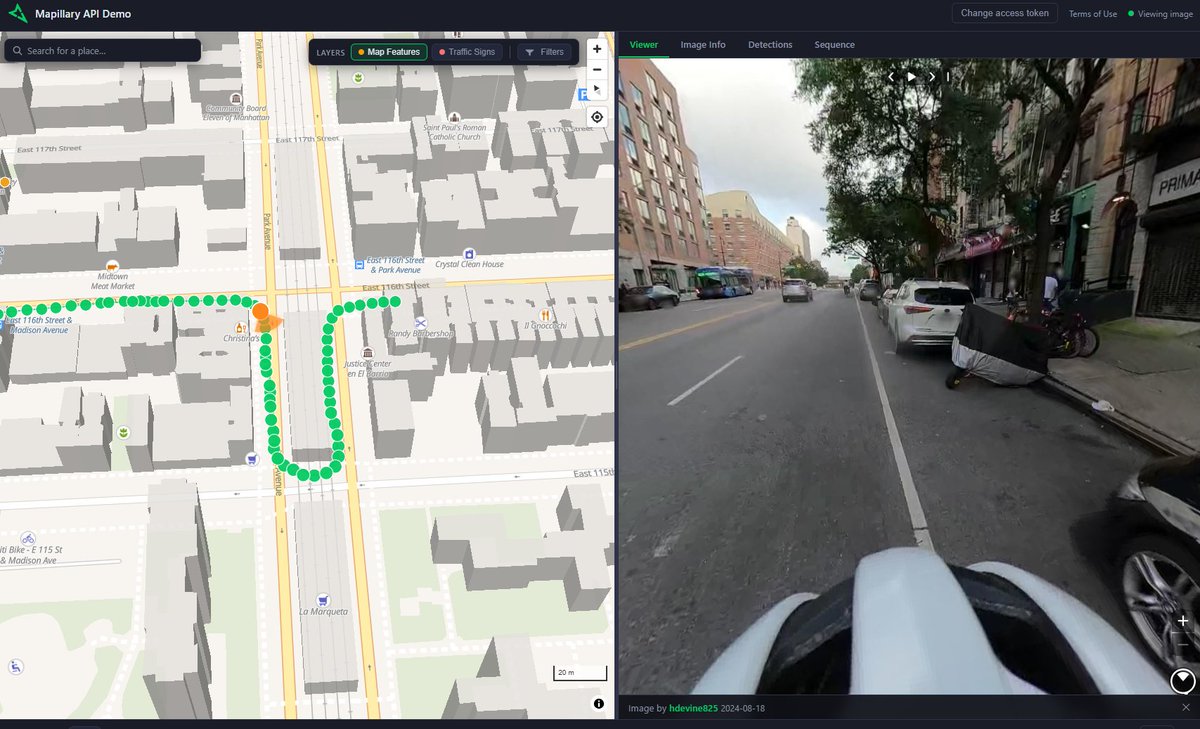
Introducing the Mapillary API Demo! 🌐
An interactive web app to test our API’s capabilities. Source code included.
Blog: blog.mapillary.com/update/20…
GitHub: github.com/mapillary/api-dem…
#Mapillary #GIS #OpenSource #Geospatial
6
534
Apr 20
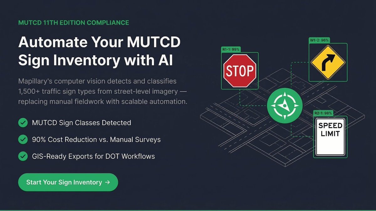
Mapillary Update - MUTCD Codes are Live on the Mapillary API
We're excited to share that you can now extract traffic sign data from Mapillary’s street-level imagery using official MUTCD through our API.
Get started : mapillary.com/developer/api-…
#Mapillary #GIS #DOT #MUTCD
1
3
327
Apr 8
🌍 Mapillary March: Top Mappers 🏅
Congrats to this month's top contributors!
From veterans to newcomers, your imagery supports maps around the world.
Amazing work to our community!
Happy Mapping! 📸
#GIS #Mapillary #Geospatial #OSM #Maps
2
295
Apr 7
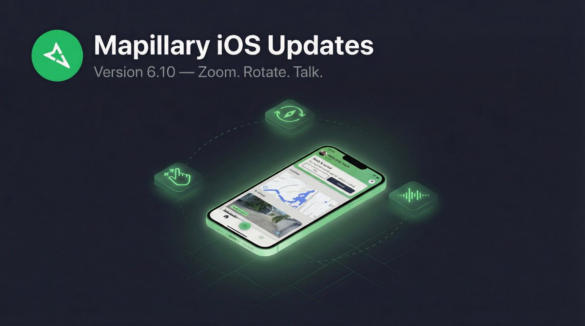
Zoom, Rotate, and Talk: What’s New in Mapillary for iOS 6.10 📱
We’ve added new tools to give you more control and a safer capture experience:
📍 Pinch to Zoom
🤏 Two Finger Rotation
🗣️ Siri Integration
Read the blog today!
blog.mapillary.com/update/20…
2
299
Mar 13
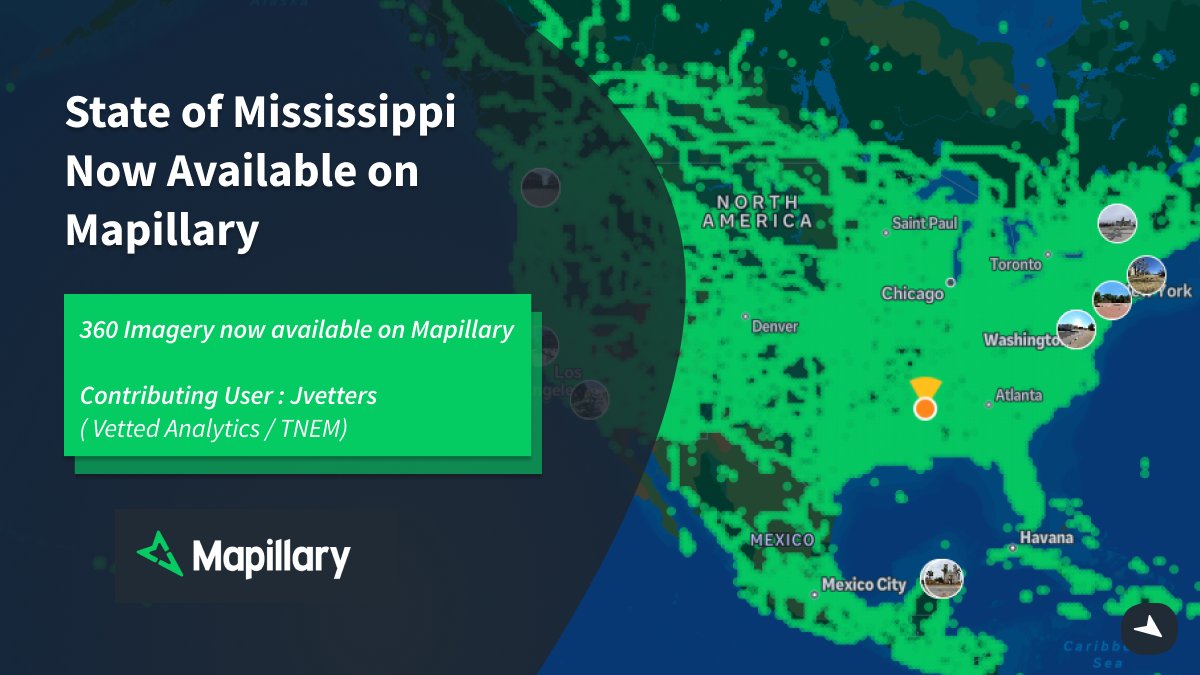
1.5M images. 4 vehicles. 1 mission. 🛣️
Check out our latest Spotlight: Josh Vetters & Vetted Analytics - @mapillary @GoPro to secure FEMA funding for MS & TN DOTs.
Providing a "driver’s eye view" for disaster recovery.
Watch: youtube.com/watch?v=h6YMLmxc…
#GIS #Mapillary #FEMA
3
268
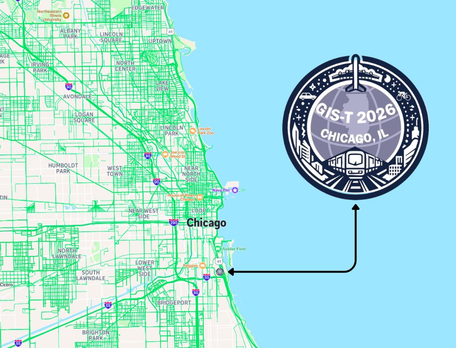
Mar 10
Next stop: Chicago!
The Mapillary team is headed to #GIST2026.
We’re ready to talk all things street-level imagery and transport innovation. Stop by our booth to see how we’re scaling GIS workflows with the community.
See you there! 🌎
#GIST2026 #Mapillary #GIS #Chicago
1
241
Mar 5
Big update for Mapillary on iOS 📣
Ever had your car hood photobomb your street-level captures? Not anymore. With pinch-to-zoom now on the camera screen, you can crop out distractions and frame your shots exactly the way you want.
1
1
515
Mar 5
But that's just the start. Here's what's new:
📷 Pinch-to-zoom on camera:
🔍 Zoom & pan on captured images
🧭 Map rotation
🗣️ Siri & Shortcuts integration
Whether you're mapping by car or bike, this update makes capturing street-level imagery on iOS easier than ever.
1
485
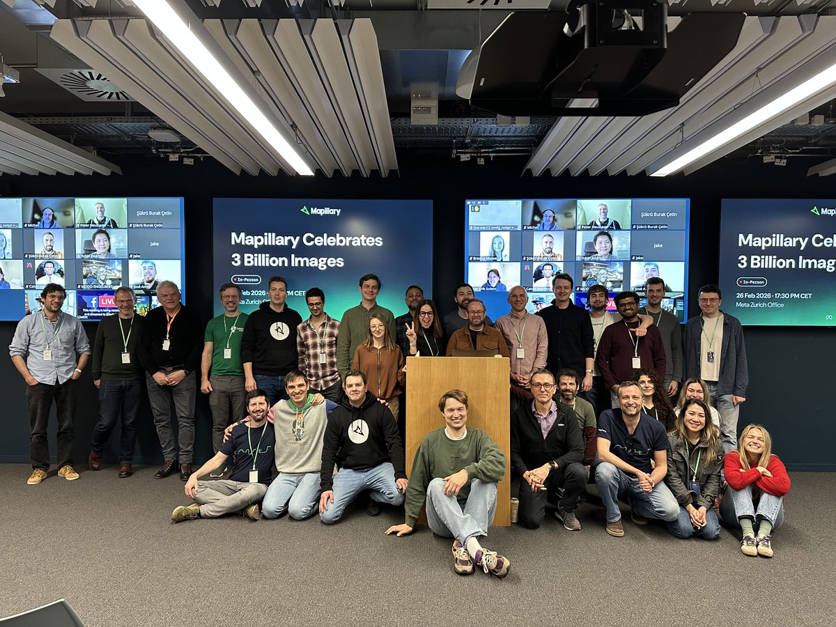
Feb 27
Mapillary 3 Billion🌍
Thanks to our community and founders for celebrating this milestone with us.
From 2013 to today, your contributions drive our journey. Great presentations from Boris, Varun, and Said highlighting the work behind 3B images.
Onward to 4 Billion!
4
182
Feb 20
Going Fast : Reserve Your Spot for the 3B Celebration! 🌍
Limited spots are going quickly for the Mapillary 3Billion Celebration. Sign up to reserve your spot.
Come and meet the team in Zurich!
Sign up: eventbrite.co.uk/e/mapillary…
5
229
Feb 20
Exciting to see our community capturing around the world in 2026! - Check out the awesome captures by @josephkerski
Tag @mapillary in your captures to get featured!
Feb 20

My Mapillary track at Sombrero Marsh in Boulder Colorado youtu.be/RyHjEjGXEp8?si=bO65… via @YouTube. Thanks @mapillary
1
200
Feb 16
Get the Street Level View : Capture with Mapillary 🌍
While Satellite data sets the stage, for ground-truth data, you need immersive high-resolution street level imagery.
Get started with Mapillary : mapillary.com/app
#Mapillary #GIS #Transportation #Surveying
1
6
610
Feb 9
Mapillary is coming to #FedGIS2026 🌎
Come and say hello to the team in Washington DC at the largest event for federal GIS professionals!!
If you’re attending and want to discuss all things Mapillary, reach out!
#Mapillary #GIS #GEOINT #AI #FederalIT
2
292
Feb 3
🌍GeoDC Meet-up with @mapillary !
We are excited to be teaming up with GeoDC at the Meta DC Office to host an evening of lightning talks and networking with other geospatial professionals around DC.
Sign up here: meetup.com/geo-dc/events/313…
#Mapillary #GeoDC #GIS #Geospatial

1
7
353
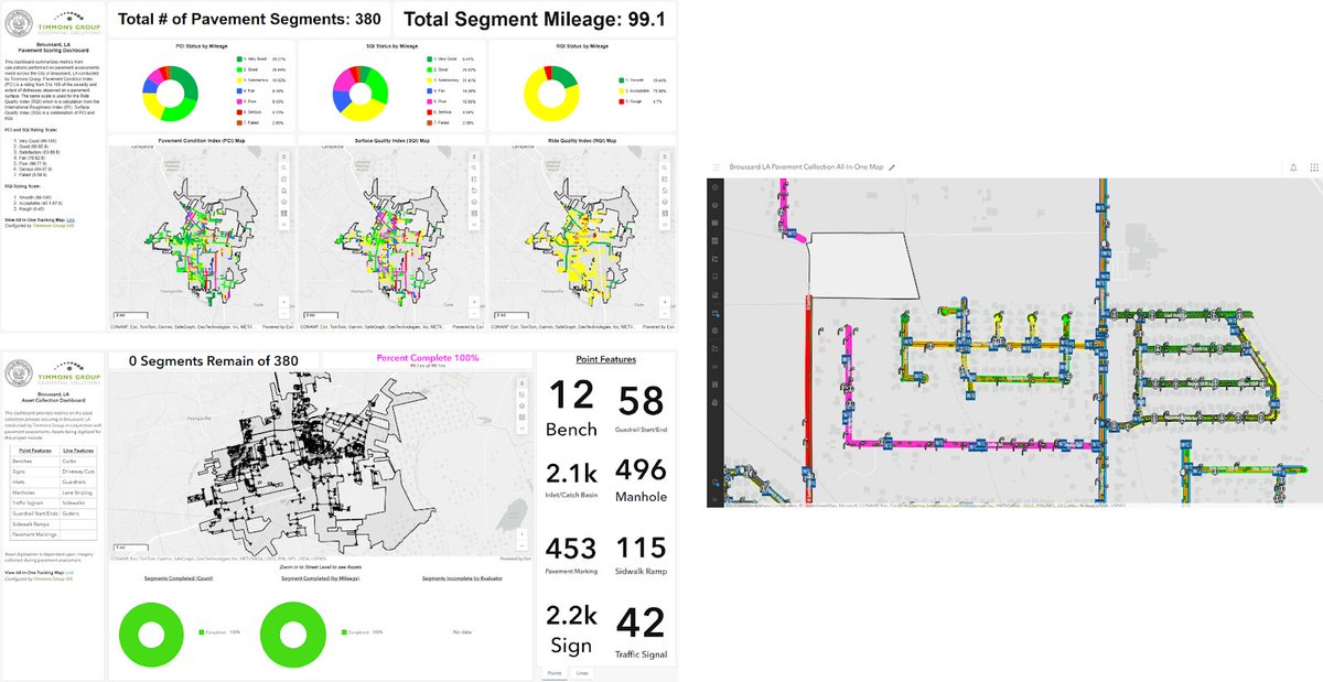
Jan 30
🌍 @mapillary x @timmonsgroup 🛣️
See how Andrew Barron & Brian Kingery use sensor trucks @Mapillary @Esri to create a "virtual window" into road conditions and build custom management solutions.
Read more: blog.mapillary.com/update/20…
#GIS #Mapillary

1
5
475