Cartographer, researcher, writer
Joined September 2010
- Tweets 865
- Following 186
- Followers 3,606
- Likes 166
156 Photos and videos


14 Jun 2022
FINAL deadline for #AutoCarto2022 extended abstracts is pushed to June 22! Submit your abstract soon! #GIS #maps #cartography #ethics @cartographyGIS
2
2
7 Jun 2022
June 15 is the deadline to submit your abstract for #AutoCarto2022!
With the theme "Ethics in Mapping", it's a great opportunity to learn and share!
2
2
18 Feb 2022
Blast from the past - my first ArcWatch tip from over 10 years ago - and strangely it is still relevant! esri.com/news/arcwatch/0911/… @arcwatch #arcgis #arcmap #esri
17 Feb 2022
Steve beat me to it - take a look - new amazing yet easy capabilities for online mapping with ArcGIS!
12 Feb 2022

1
Esri Mapping Center retweeted

17 Feb 2022
So many interesting and important topics relevant to the theme of Ethics in Mapping!
16 Feb 2022

Join us for cartogis.org/autocarto/autoc… AutoCarto 2022 with a focus on #ethics in #mapping #cartography Thank you to my colleague @_AileenBuckley for the work on this important and exciting event!
1
1
4 Feb 2022
The Mapmaker's Mantra "is presented with the intention of reinforcing ethical behavior in mapmaking." esri.com/arcgis-blog/product… #cartography #maps #gischat @AllenCarroll @deepseadawn @John_M_Nelson @Mark_Cygan @jherries @icawebsite @cartographyGIS
1
5
22 Oct 2021
Just a reminder that this Twitter account will be closing soon. Please see @_AileenBuckley for the same great content. Thanks!
21 Oct 2021
Just a quick tweet that this account will be closing soon. Please follow @_AileenBuckley instead for the same great content!
1
13 Jul 2021
Deadline for requests for space in the International Cartographic Exhibition is the end of this month, so if you are planning to share your map in the ICE, please email abuckley@esri.com by July 26th. See cartogis.org/usnc-ica/ for details. #maps #cartography #ICC2021 #ICA #USNC
20 May 2021
New #ArcWatch tip on how to add arrowheads to lines in #ArcGIS Pro: esri.com/about/newsroom/arcw…. #Esri #cartography #maps #ArcGISPro
1
20 May 2021
Want to show your maps in the International Cartographic Exhibition at #ICC2012? Send a note of intent by June 15. See details here: cartogis.org/usnc-ica/
1
2
20 May 2021
Want to show your maps in the International Cartographic Exhibition at #ICC2012? Send a note of intent by June 15. See details here: cartogis.org/usnc-ica/
1
1
20 May 2021
Deadlines are approaching for the International Cartographic Conference #ICC2021 - abstracts and travel funding requests by May 28. See cartogis.org/usnc-ica/.
Esri Mapping Center retweeted

9 Mar 2021
Need resources for teaching and research in higher ed? Visit ow.ly/zkFW50DNcq6 to check out our recently updated webpage #Geodesign and #Urban & Regional Planning.💡
This resource provides you:
-Planning tools to enhance #planning practices
-Training/Webinars
-Case studies

3
7
24 Feb 2021
The February issue of ArcWatch (online) was just published. Visit
esri.com/about/newsroom/arcw…. Contains a short tip Aileen Buckley wrote on the Quick Access Toolbar—the fastest but most frequently overlooked way to reach the commands you often use in #ArcGIS Pro.
1
1
24 Feb 2021
The winter issue of #ArcUser is available online and subscribers to the print edition should have their copies. Visit esri.com/about/newsroom/arcu….
1
2
23 Feb 2021
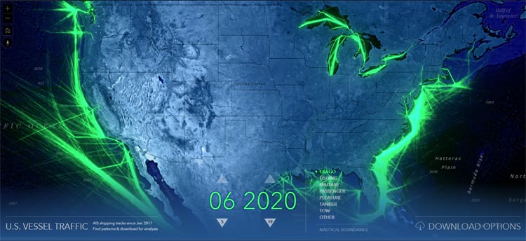
The #ArcGIS #LivingAtlas U.S. Vessel Traffic application is a new and fun tool that lets you explore the paths of vessels in and around U.S. waters. And it provides a simple and efficient way to download manageable-sized, area-specific, excerpts. livingatlas.arcgis.com/vesse…
1
Esri Mapping Center retweeted
8 Feb 2021
A #ArcGISUrban webinar is coming to you virtually on February 24th, 10am - 11am PST. Learn how to use ArcGIS Urban for #geodesign and visit go.esri.com/smartplanning-20… to join us for a panel discussion with higher education faculty members @gcoutuWCU, @mmeehhaann and more. 💡
#3DGIS

11
18
18 Nov 2020
Song Gao @gissong & colleagues talk about a #cartographic framework for movement in #AutoCarto2020—cartogis.org/autocarto/autoc…! Happy #GISDay!
1
18 Nov 2020
Somayeh Dodge @smayadodge talks about a #cartographic framework for movement in #AutoCarto2020—cartogis.org/autocarto/autoc…! Happy #GISDay!
1