
Digital Meteorologist | Creative Technologist | The Internet's Weather Man |
Joined January 2009
- Tweets 14,363
- Following 1,306
- Followers 496,037
- Likes 19,420
4,347 Photos and videos


Ryan Hall, Y’all retweeted

A Tornado Warning for Missouri until 9 PM CDT. A confirmed tornado is on the ground. TAKE COVER NOW! Ryan's tracking this LIVE: youtube.com/watch?v=i1JO3GTf…

1
13
83
13,455
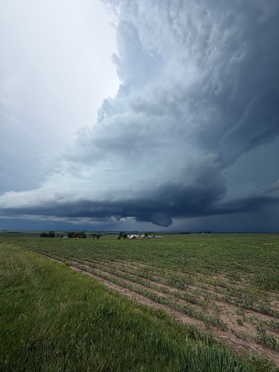
It's getting wild in Kansas City.
Those strong winds did not disappoint. Watch the exact moment the storm front slams into this stadium live on camera.
9
29
456
60,168
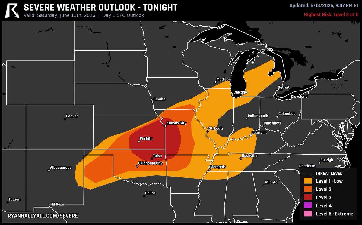
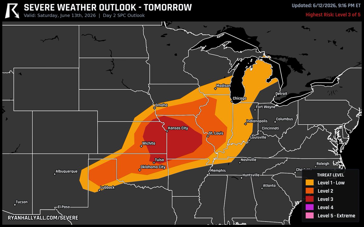
Eastern Kansas, northeast Oklahoma, and western/central Missouri just got bumped up to a Level 3 risk for tomorrow, Sunday.
A line of storms is rolling southeast and should hold together into the night. Damaging wind is the main worry, with some gusts pushing 75 mph. A couple quick tornadoes and large hail are possible too, especially around Kansas City and Joplin. Keep your phone loud overnight.
16
39
229
22,598
GIANT hail.
Ashley had to grab a tape measure for this massive stone that fell a little while ago in Floral, KS.
25
82
720
25,670
This storm in Kansas is trying to do something.
We've got some serious rotation near Lyons and Little River right now. Keep a close eye on this one if you're in the area.
33
279
24,482
NOODLE
From a viewer named Chris in Dodge City, KS
13
30
626
30,805
Ominous KANSAS storm.
Elijah Gonzalez caught this system trying to develop a wall cloud a little while ago near Highland.
9
46
503
18,025
Staying cool during a close call.
That lightning bolt was way too close for comfort, but Freddy McKinney is completely unfazed.
3
21
362
30,480
Ryan Hall, Y’all retweeted
Tornado Warning for Arkansas until 1:45 PM CDT. Radar indicates rotation and quarter-sized hail. Take cover now! We're tracking this LIVE on YouTube: youtube.com/watch?v=rqHW2Hhg…

3
21
84
14,618
That Level 3 risk we flagged for tomorrow is now today across Missouri, Kansas, and Oklahoma.
This one is messy in a good-to-know way. Leftover spin from overnight storms is hanging around Oklahoma and Kansas, and those quiet little features will help fire fresh storms this afternoon as the heat builds ahead of a cold front.
Damaging wind is the headline. As storms clump together into lines this evening, some gusts could reach 75 mph, the kind that snap limbs and knock out power. Large hail and a few tornadoes are on the table too, mainly late afternoon into evening across western and southwest Missouri as the winds aloft crank up.
Multiple rounds are likely, so don't assume the first storm is the last one.
12
79
548
39,729
The nicest weather in the USA today is split between two corners of the country: the Pacific Northwest and upstate New York, think Spokane and Syracuse.
Dry, clear air keeps skies near empty for a Beautiful day in both. Most of the country still lands Decent to Fair, but keep an eye on Missouri, Kansas, and Illinois, where a Level 3 of 5 severe storm risk sets up. Everybody else, the sun is strong so grab the sunscreen and enjoy it.
2
27
319
24,122
One to watch for Wednesday.
SPC has a 15% severe risk up across Missouri, Illinois, and Indiana. A surface low rolls across Iowa, dragging Gulf moisture north into a warm sector that loads up with strong instability and serious wind shear.
The wildcard is the evening low-level jet. If it cranks up, these storms could clump into one big complex overnight with a long swath of damaging wind.
Still 4 days out, so the area will shift. More on this soon.
2
29
265
23,266
The most likely place in the USA to see a tornado tomorrow is around Philadelphia, PA, Washington, DC, and Baltimore, MD. This is a Level 1 risk for tornadoes.
95
243
3,636
329,965
One to watch for Thursday: SPC has a 15% severe risk up across Pennsylvania, Ohio, and West Virginia.
This is the back half of a multi-day setup. An 80-100 kt jet aloft rides east over the region, and the big question is whether a wind-packed line of storms holds together as it pushes through.
Still 5 days out, so the exact area will shift. More on this soon.
2
28
282
27,327

Jun 13
The Storm Prediction Center just bumped eastern Kansas, northeast Oklahoma, and much of western and central Missouri up to a Level 3 risk for tomorrow, Saturday.
Here's the story: storms fire late Saturday afternoon near a heating corridor over eastern Kansas, then grow into clusters that push southeast into the evening. Damaging wind is the headline, with a few gusts potentially topping 70 mph as that line organizes overnight.
A couple early supercells could drop large hail and even a quick tornado before things go linear. If you're around Kansas City or Joplin, keep an eye on the sky Saturday evening.
16
97
690
51,186
Jun 12
Yesterday we covered a major tornado outbreak across Illinois and Indiana.
68 tornado warnings. 8 PDS warnings. A rare Tornado Emergency. A confirmed EF3 in Kouts. 90 mph winds tearing through Streator and Dwight. Over 400,000 without power at the peak.
And still, zero confirmed deaths at this hour. People got the warnings and took shelter. That's remarkable.
The Y'all Squad is already on the ground in Streator delivering rapid relief, and thanks to you we've raised $130,000 for these communities. Tomorrow our crews push into Springfield, IL and Kouts, IN.
33
259
2,952
138,231
Jun 12
The most likely place in the USA to see a tornado tomorrow is around Kansas City, MO, Topeka, KS, and Lamoni, IA. This is a Level 2 risk for tornadoes.
10
27
319
22,008

Jun 12
Sunday night looks like a great one for dark skies, and there's a bonus.
The moon is completely gone, so the sky stays black from sunset to sunrise, perfect for stars and the Milky Way away from city lights. The cleanest air should be across the Intermountain West and Northern Plains, from Nevada and inland California up through Montana and the Dakotas.
There's also a chance for faint northern lights low on the northern horizon, maybe as far south as roughly Iowa or Nebraska to the eye, and a camera pointed north could pick up more color down near Chicago or Omaha. Best odds are up north. The Gulf Coast and Southeast will likely be socked in with clouds and humidity.
5
26
263
19,285
Ryan Hall, Y’all retweeted

Jun 12
Timelapse shot of just a section of damage path north of Kouts, IN. This was a very violent #tornado with significant ground scaring.
@MyRadarWX #inwx
34
326
2,027
160,430